CPAC: LANE - Post-Tropical
Moderator: S2k Moderators
-
cycloneye

- Admin

- Posts: 139051
- Age: 67
- Joined: Thu Oct 10, 2002 10:54 am
- Location: San Juan, Puerto Rico
Re: CPAC: LANE - Hurricane: Hurricane Warning Issued for Hawaii County / Hurricane Watch for OAHU
Kingarabian ,in which island you live? Stay safe my friend.
0 likes
Visit the Caribbean-Central America Weather Thread where you can find at first post web cams,radars
and observations from Caribbean basin members Click Here
and observations from Caribbean basin members Click Here
-
NotoSans
- Category 5

- Posts: 1366
- Age: 24
- Joined: Sun Sep 27, 2015 1:15 am
- Location: Hong Kong
- Contact:
Re: CPAC: LANE - Hurricane: Hurricane Warning Issued for Hawaii County / Hurricane Watch for OAHU
WTPA42 PHFO 220304
TCDCP2
Hurricane Lane Discussion Number 29
NWS Central Pacific Hurricane Center Honolulu HI EP142018
500 PM HST Tue Aug 21 2018
Lane remains a powerful hurricane this afternoon, with a well-
developed warm eye completely surrounded by persistent cold cloud
tops. The Hurricane Hunter aircraft from the 53rd Weather
Reconnaissance Squadron has been flying through Lane during the day,
and has provided invaluable data. The central pressure dropped
around 10 mb between the 18Z and 00Z fixes, with the last eye
dropsonde measuring 930 mb with 16 kt splash wind, yielding a
minimum pressure estimate of 929 mb. Peak SFMR winds during this
mission were 140 kt, and max flight level winds were 146 kt.
Subjective Dvorak current intensity estimates range from 6.5/127 kt
to 7.0/140 kt, with the latest ADT current intensity holding steady
at 6.5/127 kt. Although the central pressure has dropped sharply
during the last 18 hours, it is now about what one would expect for
a hurricane of strong Category 4 intensity in the Central Pacific
basin, and based primarily on the aircraft data the intial intensity
is held at 135 kt for this advisory.
Lane has turned slightly to the WNW today, and the initial motion
for this advisory is 285/8 kt. Lane has been moving generally
westward to the south of a mid-level ridge during the past several
days. However, this will be changing soon, as Lane begins to round
the western periphery of this ridge and moves into an area of
relatively light steering flow. This is expected to allow the
cyclone to gain latitude as its forward speed diminishes. The
hurricane is forecast to continue moving west-northwest tonight,
then turn to the northwest on Wednesday, and to the north-northwest
on Thursday, as it moves between the mid-level ridge to the east and
a developing upper-level trough to the northwest of Hawaii. After
this point, the track and intensity forecast become increasingly
uncertain, as the majority of the reliable model guidance
brings Lane very close to the islands with potential interaction
between Lane and the mountainous terrain of the islands. This
interaction combined with increasing vertical wind shear leads to a
weakened Lane being steered to the west by the low-level trade wind
flow during the later forecast periods. The new track forecast has
been nudged slightly to left through 36 hours, then slightly to the
right or closer to the islands at 72 hours, in very good agreement
with the multi-model consensus HCCA.
Water temperatures along the forecast track will be sufficiently
warm to support a major hurricane, and thus any significant
weakening before Lane draws closer to the Hawaiian Islands will
likely be due to increasing wind shear. Through the next 36 to 48
hours, shear is expected to remain light, and we expect only slow
weakening as the cyclone moves over slightly cooler SSTs and may be
impacted by eyewall replacement cycles. At 72 hours and beyond, the
forecast anticipates a sharp increase in shear as Lane moves closer
to the large upper trough to the northwest of the main Hawaiian
Islands. The new intensity forecast is very similar to the previous
forecast, and continues to follow the trend of the multi-model
consensus IVCN.
In addition to continued storm penetrations by the Hurricane Hunters
of the 53rd Weather Reconnaissance Squadron, the NOAA P-3 aircraft
will also be flying into Lane again this evening. The NOAA G-IV
aircraft once again sampled the larger scale environment during the
day to help with initialization of the forecast models.
KEY MESSAGES:
1. Lane is forecast to move dangerously close to the main Hawaiian
Islands as a hurricane later this week, potentially bringing
damaging winds and life-threatening flash flooding from heavy
rainfall anywhere in the state. As Lane is expected to be
slow-moving as it nears the islands, it will produce large and
damaging surf.
2. As Lane moves up from the southeast, the earliest potential
threat to land will be for the Big Island, where a Hurricane Warning
is now in effect. Preparations there should be rushed to completion
as tropical-storm force winds are forecast to arrive in the warning
area by late Wednesday or early Thursday. A Hurricane Watch remains
in effect for Maui County, and is now posted for Oahu, with
tropical-storm force winds possibly beginning Thursday or Thursday
night.
3. Due to a continued high degree of uncertainty on the forecast
track and intensity of Lane, hurricane impacts could be felt across
any of the Hawaiian Islands. It is too early to predict which, if
any, of the islands are directly impacted. Remember that life
threatening weather conditions can extend well away from the center
of the hurricane. Interests throughout Hawaii are urged to closely
monitor the progress of Lane during the next few days.
FORECAST POSITIONS AND MAX WINDS
INIT 22/0300Z 14.5N 154.0W 135 KT 155 MPH
12H 22/1200Z 15.0N 155.0W 130 KT 150 MPH
24H 23/0000Z 16.0N 156.0W 125 KT 145 MPH
36H 23/1200Z 17.2N 156.8W 115 KT 130 MPH
48H 24/0000Z 18.6N 157.3W 100 KT 115 MPH
72H 25/0000Z 21.1N 158.7W 75 KT 85 MPH
96H 26/0000Z 21.5N 161.5W 50 KT 60 MPH
120H 27/0000Z 21.0N 164.5W 40 KT 45 MPH
$$
Forecaster Jacobson
0 likes
Personal Forecast Disclaimer:
The posts in this forum are NOT official forecast and should not be used as such. They are just the opinion of the poster and may or may not be backed by sound meteorological data. They are NOT endorsed by any professional institution or storm2k.org. For official information, please refer to RSMC and NWS products.
The posts in this forum are NOT official forecast and should not be used as such. They are just the opinion of the poster and may or may not be backed by sound meteorological data. They are NOT endorsed by any professional institution or storm2k.org. For official information, please refer to RSMC and NWS products.
-
storm_in_a_teacup

- Category 1

- Posts: 348
- Joined: Wed Aug 16, 2017 5:01 pm
- Location: Huntsville, Alabama
- Contact:
Re: CPAC: LANE - Hurricane: Hurricane Warning Issued for Hawaii County / Hurricane Watch for OAHU
cjrciadt wrote:Kingarabian wrote:Conflict of feeling for me right now. Cant help but to oooh and awe over Lane, yet knowing it's going to affect me is nuts.
That was me with Irma last year.
And me with Harvey!
...If you're anything like me, you're going to cope with this conflict by writing a story told from Lane's perspective, and then wonder how the heck you made yourself feel sorry for it.
...
I'm kind of a bit weird in that way though.
4 likes
I know I can't straddle the atmosphere...just a tiny storm in your teacup, girl.
-
MississippiWx

- S2K Supporter

- Posts: 1535
- Joined: Sat Aug 14, 2010 1:44 pm
- Location: Hattiesburg, Mississippi
Re: CPAC: LANE - Hurricane: Hurricane Warning Issued for Hawaii County / Hurricane Watch for OAHU
I got back on here expecting to see Lane in a slow decline in intensity. Wow. He is certainly still holding strong, if not still intensifying. The western side of the CDO has battled against shear, and is now much more symmetrical. I think what Hawaii needs is an eye wall replacement cycle to begin. While Lane will still be dangerous, an EWRC might be what is needed to get a quick degeneration trend started. The hurricane would not be able to fight off shear as easily. Just a hunch and crossing my fingers that this happens.
What a monster!
What a monster!
Last edited by MississippiWx on Tue Aug 21, 2018 10:19 pm, edited 1 time in total.
1 likes
This post is not an official forecast and should not be used as such. It is just the opinion of MississippiWx and may or may not be backed by sound meteorological data. It is not endorsed by any professional institution including storm2k.org. For Official Information please refer to the NHC and NWS products.
-
storminabox
- Category 1
- Posts: 260
- Joined: Sun Jul 09, 2017 10:50 pm
Re: CPAC: LANE - Hurricane: Hurricane Warning Issued for Hawaii County / Hurricane Watch for OAHU
storm_in_a_teacup wrote:cjrciadt wrote:Kingarabian wrote:Conflict of feeling for me right now. Cant help but to oooh and awe over Lane, yet knowing it's going to affect me is nuts.
That was me with Irma last year.
And me with Harvey!
...If you're anything like me, you're going to cope with this conflict by writing a story told from Lane's perspective, and then wonder how the heck you made yourself feel sorry for it.
...
I'm kind of a bit weird in that way though.
Hurricanes are incredibly beautiful and fascinating phenomena. It’s a shame that so many people’s lives are put in jeopardy because of them. Stay safe Kingarabian and all other members that live in Hawaii.
3 likes
-
Kingarabian

- S2K Supporter
- Posts: 15434
- Joined: Sat Aug 08, 2009 3:06 am
- Location: Honolulu, Hawaii
Re: CPAC: LANE - Hurricane: Hurricane Warning Issued for Hawaii County / Hurricane Watch for OAHU
cycloneye wrote:Kingarabian ,in which island you live? Stay safe my friend.
Oahu, Honolulu. Thank you for your kind words.
3 likes
RIP Kobe Bryant
-
AnnularCane

- S2K Supporter
- Posts: 2634
- Joined: Thu Jun 08, 2006 9:18 am
- Location: Wytheville, VA
Re: CPAC: LANE - Hurricane: Hurricane Warning Issued for Hawaii County / Hurricane Watch for OAHU
storm_in_a_teacup wrote:cjrciadt wrote:Kingarabian wrote:Conflict of feeling for me right now. Cant help but to oooh and awe over Lane, yet knowing it's going to affect me is nuts.
That was me with Irma last year.
And me with Harvey!
...If you're anything like me, you're going to cope with this conflict by writing a story told from Lane's perspective, and then wonder how the heck you made yourself feel sorry for it.
...
I'm kind of a bit weird in that way though.
And me with Katrina! I always thought she was beautiful, even when she was coming at me (I was living in NOLA at the time). Lane is a beauty, nothing wrong with saying so, IMO.
(I actually remember wanting to see a story or whatever from Katrina's perspective, but I never thought to write one myself.)
2 likes
-
CrazyC83
- Professional-Met

- Posts: 33393
- Joined: Tue Mar 07, 2006 11:57 pm
- Location: Deep South, for the first time!
Re: CPAC: LANE - Hurricane: Hurricane Warning Issued for Hawaii County / Hurricane Watch for OAHU
MississippiWx wrote:I got back on here expecting to see Lane in a slow decline in intensity. Wow. He is certainly still holding strong, if not still intensifying. The western side of the CDO has battled against shear, and is now much more symmetrical. I think what Hawaii needs is an eye wall replacement cycle to begin. While Lane will still be dangerous, an EWRC might be what is needed to get a quick degeneration trend started. The hurricane would not be able to fight off shear as easily. Just a hunch and crossing my fingers that this happens.
What a monster!
An ERC may not be the best news, since that could enlarge the RMW, and put more of the islands in the worst conditions.
5 likes
-
Sciencerocks
- Category 5
- Posts: 7283
- Age: 38
- Joined: Thu Jul 06, 2017 1:51 am
Re: CPAC: LANE - Hurricane: Hurricane Warning Issued for Hawaii County / Hurricane Watch for OAHU
Kingarabian wrote:cycloneye wrote:Kingarabian ,in which island you live? Stay safe my friend.
Oahu, Honolulu. Thank you for your kind words.
If it makes landfall as a cat5 will you ride it out?
0 likes
-
MississippiWx
- S2K Supporter
- Posts: 1535
- Joined: Sat Aug 14, 2010 1:44 pm
- Location: Hattiesburg, Mississippi
Re: CPAC: LANE - Hurricane: Hurricane Warning Issued for Hawaii County / Hurricane Watch for OAHU
CrazyC83 wrote:MississippiWx wrote:I got back on here expecting to see Lane in a slow decline in intensity. Wow. He is certainly still holding strong, if not still intensifying. The western side of the CDO has battled against shear, and is now much more symmetrical. I think what Hawaii needs is an eye wall replacement cycle to begin. While Lane will still be dangerous, an EWRC might be what is needed to get a quick degeneration trend started. The hurricane would not be able to fight off shear as easily. Just a hunch and crossing my fingers that this happens.
What a monster!
An ERC may not be the best news, since that could enlarge the RMW, and put more of the islands in the worst conditions.
True. Just hoping those winds wouldn’t be too much to handle by that point. It would still be better than someone taking a Cat 4 head on..
0 likes
This post is not an official forecast and should not be used as such. It is just the opinion of MississippiWx and may or may not be backed by sound meteorological data. It is not endorsed by any professional institution including storm2k.org. For Official Information please refer to the NHC and NWS products.
-
storm_in_a_teacup
- Category 1
- Posts: 348
- Joined: Wed Aug 16, 2017 5:01 pm
- Location: Huntsville, Alabama
- Contact:
Re: CPAC: LANE - Hurricane: Hurricane Warning Issued for Hawaii County / Hurricane Watch for OAHU
AnnularCane wrote:storm_in_a_teacup wrote:cjrciadt wrote:That was me with Irma last year.
And me with Harvey!
...If you're anything like me, you're going to cope with this conflict by writing a story told from Lane's perspective, and then wonder how the heck you made yourself feel sorry for it.
...
I'm kind of a bit weird in that way though.
And me with Katrina! I always thought she was beautiful, even when she was coming at me (I was living in NOLA at the time). Lane is a beauty, nothing wrong with saying so, IMO.
(I actually remember wanting to see a story or whatever from Katrina's perspective, but I never thought to write one myself.)
I did try doing stories with a personified Katrina at the time but generally the mood from people in Houston at least was very much against that. The people who had come from NOLA to Houston were the worst affected and they were EXTREMELY sensitive to the topic. I feel like Harvey, as bad as it was, cannot really compare to Katrina in the level at which it made people miserable.
That one time I won a costume contest by dressing up as hurricane Katrina for Halloween didn't help endear me to people. [Hey I thought it counted as something scary...]
Last edited by storm_in_a_teacup on Tue Aug 21, 2018 10:35 pm, edited 1 time in total.
2 likes
I know I can't straddle the atmosphere...just a tiny storm in your teacup, girl.

Re: CPAC: LANE - Hurricane: Hurricane Warning Issued for Hawaii County / Hurricane Watch for OAHU
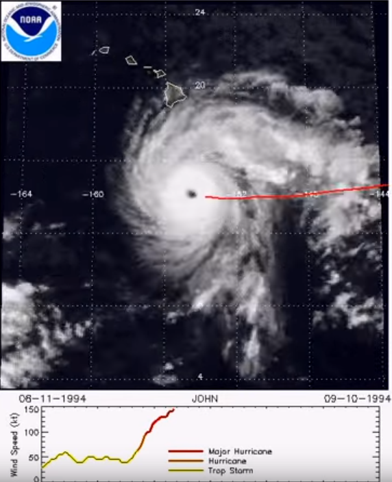
A hurricane we can sort of analog Lane to is John 1994. Similar vicinity...peaked at 929mb with 150kts..in very close area. In fact probably almost identical except for the bend in track.
4 likes
The above post and any post by Ntxw is NOT an official forecast and should not be used as such. It is just the opinion of the poster and may or may not be backed by sound meteorological data. It is NOT endorsed by any professional institution including Storm2k. For official information, please refer to NWS products.
Help support Storm2K!

-
Bocadude85

- Category 5
- Posts: 2941
- Age: 37
- Joined: Mon Apr 18, 2005 2:20 pm
- Location: Honolulu,Hi
Re: CPAC: LANE - Hurricane: Hurricane Warning Issued for Hawaii County / Hurricane Watch for OAHU
0Z GFS Big Island bound at 54 hours
1 likes
-
galaxy401

- Category 5
- Posts: 2299
- Age: 28
- Joined: Sat Aug 25, 2012 9:04 pm
- Location: Casa Grande, Arizona
Re: CPAC: LANE - Hurricane
What are your predictions in what recon will find for Lane?
I think it will be around 145 knots with pressure at 925.
I think it will be around 145 knots with pressure at 925.
0 likes
Got my eyes on moving right into Hurricane Alley: Florida.
-
Kingarabian
- S2K Supporter
- Posts: 15434
- Joined: Sat Aug 08, 2009 3:06 am
- Location: Honolulu, Hawaii
Re: CPAC: LANE - Hurricane
00z GFS initialized off as well. Affects the landfall MSLP of Lane.
0 likes
RIP Kobe Bryant
-
NotoSans
- Category 5
- Posts: 1366
- Age: 24
- Joined: Sun Sep 27, 2015 1:15 am
- Location: Hong Kong
- Contact:
Re: CPAC: LANE - Hurricane
Highest unflagged SFMR winds reported by the NOAA aircraft were 152 knots so far.
0 likes
Personal Forecast Disclaimer:
The posts in this forum are NOT official forecast and should not be used as such. They are just the opinion of the poster and may or may not be backed by sound meteorological data. They are NOT endorsed by any professional institution or storm2k.org. For official information, please refer to RSMC and NWS products.
The posts in this forum are NOT official forecast and should not be used as such. They are just the opinion of the poster and may or may not be backed by sound meteorological data. They are NOT endorsed by any professional institution or storm2k.org. For official information, please refer to RSMC and NWS products.
-
CrazyC83
- Professional-Met
- Posts: 33393
- Joined: Tue Mar 07, 2006 11:57 pm
- Location: Deep South, for the first time!
Re: CPAC: LANE - Hurricane
Need some more data from the other side, but so far we have 154 kt SFMR and 146 kt FL.
0 likes
-
Sciencerocks
- Category 5
- Posts: 7283
- Age: 38
- Joined: Thu Jul 06, 2017 1:51 am
Re: CPAC: LANE - Hurricane
NotoSans wrote:Highest unflagged SFMR winds reported by the NOAA aircraft were 152 knots so far.
Yep, so the guess of 155 knots is probably a good one.
0 likes
-
Kingarabian
- S2K Supporter
- Posts: 15434
- Joined: Sat Aug 08, 2009 3:06 am
- Location: Honolulu, Hawaii
-
NotoSans
- Category 5
- Posts: 1366
- Age: 24
- Joined: Sun Sep 27, 2015 1:15 am
- Location: Hong Kong
- Contact:
Re: CPAC: LANE - Hurricane
A blend of flight-level and SFMR winds would yield an intensity of around 140 knots. Recon definitely supports a category 5 now, and I would go with 145 - 150 knots for the initial intensity.
Last edited by NotoSans on Tue Aug 21, 2018 11:01 pm, edited 1 time in total.
1 likes
Personal Forecast Disclaimer:
The posts in this forum are NOT official forecast and should not be used as such. They are just the opinion of the poster and may or may not be backed by sound meteorological data. They are NOT endorsed by any professional institution or storm2k.org. For official information, please refer to RSMC and NWS products.
The posts in this forum are NOT official forecast and should not be used as such. They are just the opinion of the poster and may or may not be backed by sound meteorological data. They are NOT endorsed by any professional institution or storm2k.org. For official information, please refer to RSMC and NWS products.
Who is online
Users browsing this forum: No registered users and 43 guests