
CPAC: LANE - Post-Tropical
Moderator: S2k Moderators
-
Kingarabian

- S2K Supporter

- Posts: 15434
- Joined: Sat Aug 08, 2009 3:06 am
- Location: Honolulu, Hawaii
-
Kingarabian
- S2K Supporter
- Posts: 15434
- Joined: Sat Aug 08, 2009 3:06 am
- Location: Honolulu, Hawaii
Re: CPAC: LANE - Hurricane
18z GFS through hour 96-120:

Some weird process of bouncing off the big island, and decoupling. Don't know what's going on here.
Some weird process of bouncing off the big island, and decoupling. Don't know what's going on here.
Last edited by Kingarabian on Sun Aug 19, 2018 5:11 pm, edited 1 time in total.
0 likes
RIP Kobe Bryant
-
Yellow Evan

- Professional-Met

- Posts: 15952
- Age: 25
- Joined: Fri Jul 15, 2011 12:48 pm
- Location: Henderson, Nevada/Honolulu, HI
- Contact:
Re: CPAC: LANE - Hurricane
Most recent runs of the GFS and ECMWF fundamentally don't change anything.
However the real fun is tonight.
1. Synoptic data will be in the 0z runs of the GFS, ECMWF, and UKMET
2. Recon is at 6z.
However the real fun is tonight.
1. Synoptic data will be in the 0z runs of the GFS, ECMWF, and UKMET
2. Recon is at 6z.
2 likes
-
Kingarabian
- S2K Supporter
- Posts: 15434
- Joined: Sat Aug 08, 2009 3:06 am
- Location: Honolulu, Hawaii
Re: CPAC: LANE - Hurricane
Yellow Evan wrote:Most recent runs of the GFS and ECMWF fundamentally don't change anything.
However the real fun is tonight.
1. Synoptic data will be in the 0z runs of the GFS, ECMWF, and UKMET
2. Recon is at 6z.
Yup, can't wait.
0 likes
RIP Kobe Bryant
-
galaxy401

- Category 5

- Posts: 2299
- Age: 28
- Joined: Sat Aug 25, 2012 9:04 pm
- Location: Casa Grande, Arizona
Re: CPAC: LANE - Hurricane
According to the GFS, Hawaii is like some sort of magnet that is sucking up Lane. Interesting seeing a model conflict between that and the Euro.
0 likes
Got my eyes on moving right into Hurricane Alley: Florida.
-
Yellow Evan
- Professional-Met
- Posts: 15952
- Age: 25
- Joined: Fri Jul 15, 2011 12:48 pm
- Location: Henderson, Nevada/Honolulu, HI
- Contact:
-
Kingarabian
- S2K Supporter
- Posts: 15434
- Joined: Sat Aug 08, 2009 3:06 am
- Location: Honolulu, Hawaii
Re: CPAC: LANE - Hurricane
galaxy401 wrote:According to the GFS, Hawaii is like some sort of magnet that is sucking up Lane. Interesting seeing a model conflict between that and the Euro.

0 likes
RIP Kobe Bryant
-
Kingarabian
- S2K Supporter
- Posts: 15434
- Joined: Sat Aug 08, 2009 3:06 am
- Location: Honolulu, Hawaii
Re: CPAC: LANE - Hurricane
Started the morning off doing pretty good but last couple of frames showing shear again:

1 likes
RIP Kobe Bryant
-
Kingarabian
- S2K Supporter
- Posts: 15434
- Joined: Sat Aug 08, 2009 3:06 am
- Location: Honolulu, Hawaii
Re: CPAC: LANE - Hurricane
18z HWRF and HMON coming in more north. Here is the HMON trend:

0 likes
RIP Kobe Bryant
-
gatorcane

- S2K Supporter
- Posts: 23499
- Age: 46
- Joined: Sun Mar 13, 2005 3:54 pm
- Location: Boca Raton, FL
Re: CPAC: LANE - Hurricane
galaxy401 wrote:According to the GFS, Hawaii is like some sort of magnet that is sucking up Lane. Interesting seeing a model conflict between that and the Euro.
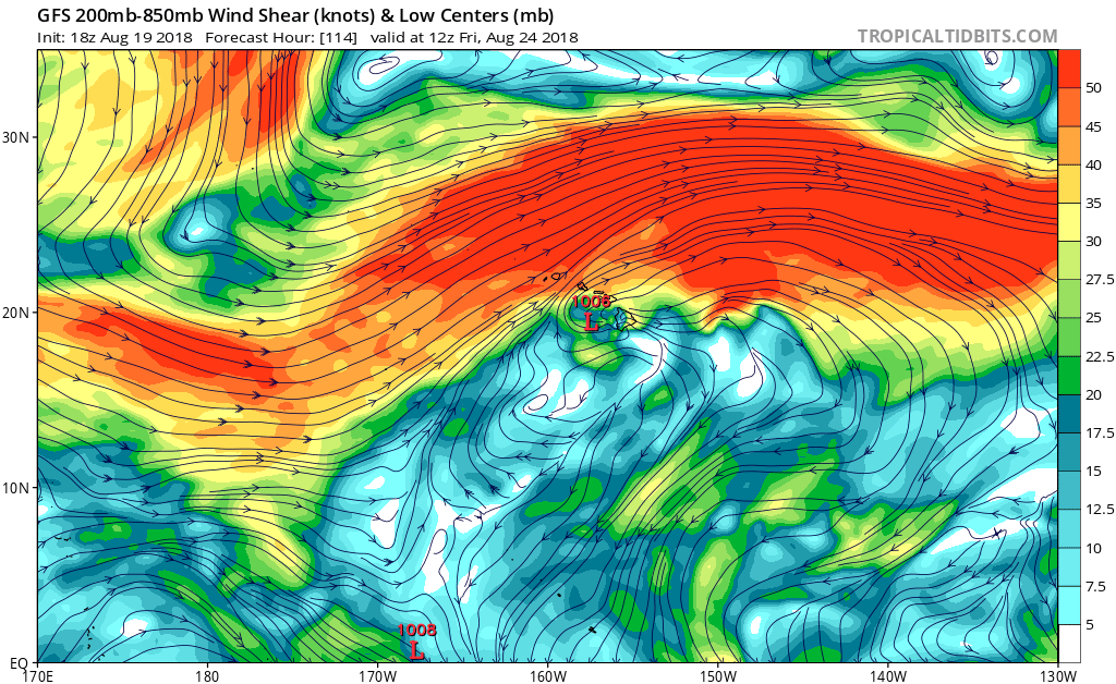
Maybe a magnet but Lane looks to weaken quite dramatically on its approach to Hawaii based on the 18Z GFS. Big shear zone:
0 likes
-
Kingarabian
- S2K Supporter
- Posts: 15434
- Joined: Sat Aug 08, 2009 3:06 am
- Location: Honolulu, Hawaii
Re: CPAC: LANE - Hurricane
Big shift closer to the islands on the 18z HWRF:


Now to see if the TUTT lifts out or not..
Now to see if the TUTT lifts out or not..
0 likes
RIP Kobe Bryant
Re: CPAC: LANE - Hurricane
HWRF blasts it apart just west of the big island
Not sure this will shear off that quickly
Not sure this will shear off that quickly
2 likes
-
Kingarabian
- S2K Supporter
- Posts: 15434
- Joined: Sat Aug 08, 2009 3:06 am
- Location: Honolulu, Hawaii
Re: CPAC: LANE - Hurricane
Alyono wrote:HWRF blasts it apart just west of the big island
Not sure this will shear off that quickly
UKMET keeps this a strong Hurricane all the way till 20N.
0 likes
RIP Kobe Bryant
-
Yellow Evan
- Professional-Met
- Posts: 15952
- Age: 25
- Joined: Fri Jul 15, 2011 12:48 pm
- Location: Henderson, Nevada/Honolulu, HI
- Contact:
Re: CPAC: LANE - Hurricane
Pre-0z run, right now I think the track shown by the UKMET is the most sensible, with a recruve before getting blocked near 20N.
0 likes

Re: CPAC: LANE - Hurricane
Here we go with the 0Z GFS...*should* be the first run with recon data; but I don't know how to confirm that.
0 likes
-
cycloneye

- Admin

- Posts: 139077
- Age: 67
- Joined: Thu Oct 10, 2002 10:54 am
- Location: San Juan, Puerto Rico
Re: CPAC: LANE - Hurricane
Hurricane Lane Discussion Number 21
NWS Central Pacific Hurricane Center Honolulu HI EP142018
500 PM HST Sun Aug 19 2018
Lane's satellite presentation has not changed much since late this
morning. The main features include a murky cloud-filled eye
surrounded by a symmetric convective ring. Outflow is best to the
north through northeast, but remains somewhat constricted elsewhere
in the face of 17 kt of UW-CIMSS-derived southwest vertical shear.
The coldest cloud tops, -75 to -80 degrees C, are within the north
quadrant of the convective ring. The latest subjective Dvorak
intensity estimates range from 5.0/90 kt (SAB) to 6.0/115 kt
(PHFO). JTWC estimated 5.5/102 kt while UW-CIMSS estimated 5.0/90
kt. The initial intensity for this package is set at 105 kt,
representing a slight adjustment downward using a blend of
estimates.
Initial motion is a steady 280/12 kt as Lane continues tracking
westward along the southern flank of a large subtropical ridge.
There is still quite a bit of spread in track guidance beyond day 2
as individual models handle the erosion of the western portion of
this ridge differently, thanks to the forecast intrusion of a weak
frontal band far northwest of the main Hawaiian Islands. GFS and
HWRF represent the northern edge of the guidance envelope, while
ECMWF lies along the southern edge. The current forecast track lies
within the southern third of the guidance envelope, closely
following FSSE and TVCX consensus through 96 hours, then bending
left at 120 hours and beyond between TVCX and ECMWF guidance. The
only noticeable change from the previous track is a slight bump to
the right beyond day 4 to account for an overall guidance envelope
shift to the right at days 4 and 5. The NOAA G-IV aircraft has
completed its initial synoptic sweep around Lane and the main
Hawaiian Islands, and the NOAA P-3 aircraft is about to start its
mission as of this writing. Air Force Reserve WC-130J aircraft will
begin their sampling missions through Lane this evening. The
valuable data collected during these missions will be used to
better initialize the guidance models and, hopefully, reduce the
guidance envelope spread.
The intensity forecast follows the logic of the previous one, only
with a slightly lower initial intensity. Lane will remain over
27-28 degree C waters through the forecast period, with 10 to 20 kt
of vertical shear through most of its track, at least according to
the ECMWF-derived SHIPS run. Gradual weakening is forecast through
the forecast period, closely following the shape of the DSHIP and
FSSE intensity curves but staying above the IVCN intensity curve.
Lane is forecast to pass south of the main Hawaiian Islands
Wednesday and Thursday, potentially causing local impacts as it
tracks west-northwestward. Interests in these islands should watch
the progress of Lane closely, since long-range track and intensity
forecast errors can be large.
FORECAST POSITIONS AND MAX WINDS
INIT 20/0300Z 13.8N 145.8W 105 KT 120 MPH
12H 20/1200Z 14.1N 147.5W 100 KT 115 MPH
24H 21/0000Z 14.4N 149.6W 100 KT 115 MPH
36H 21/1200Z 14.6N 151.2W 95 KT 110 MPH
48H 22/0000Z 14.9N 152.9W 90 KT 105 MPH
72H 23/0000Z 15.6N 156.2W 80 KT 90 MPH
96H 24/0000Z 17.0N 159.3W 70 KT 80 MPH
120H 25/0000Z 19.1N 161.8W 60 KT 70 MPH
$$
Forecaster Powell
0 likes
Visit the Caribbean-Central America Weather Thread where you can find at first post web cams,radars
and observations from Caribbean basin members Click Here
and observations from Caribbean basin members Click Here
-
Yellow Evan
- Professional-Met
- Posts: 15952
- Age: 25
- Joined: Fri Jul 15, 2011 12:48 pm
- Location: Henderson, Nevada/Honolulu, HI
- Contact:

-
Yellow Evan
- Professional-Met
- Posts: 15952
- Age: 25
- Joined: Fri Jul 15, 2011 12:48 pm
- Location: Henderson, Nevada/Honolulu, HI
- Contact:
Re: CPAC: LANE - Hurricane
Old disco.
WTPA42 PHFO 200306
TCDCP2
Hurricane Lane Discussion Number 21
NWS Central Pacific Hurricane Center Honolulu HI EP142018
500 PM HST Sun Aug 19 2018
Lane's satellite presentation has not changed much since late this
morning. The main features include a murky cloud-filled eye
surrounded by a symmetric convective ring. Outflow is best to the
north through northeast, but remains somewhat constricted elsewhere
in the face of 17 kt of UW-CIMSS-derived southwest vertical shear.
The coldest cloud tops, -75 to -80 degrees C, are within the north
quadrant of the convective ring. The latest subjective Dvorak
intensity estimates range from 5.0/90 kt (SAB) to 6.0/115 kt
(PHFO). JTWC estimated 5.5/102 kt while UW-CIMSS estimated 5.0/90
kt. The initial intensity for this package is set at 105 kt,
representing a slight adjustment downward using a blend of
estimates.
Initial motion is a steady 280/12 kt as Lane continues tracking
westward along the southern flank of a large subtropical ridge.
There is still quite a bit of spread in track guidance beyond day 2
as individual models handle the erosion of the western portion of
this ridge differently, thanks to the forecast intrusion of a weak
frontal band far northwest of the main Hawaiian Islands. GFS and
HWRF represent the northern edge of the guidance envelope, while
ECMWF lies along the southern edge. The current forecast track lies
within the southern third of the guidance envelope, closely
following FSSE and TVCX consensus through 96 hours, then bending
left at 120 hours and beyond between TVCX and ECMWF guidance. The
only noticeable change from the previous track is a slight bump to
the right beyond day 4 to account for an overall guidance envelope
shift to the right at days 4 and 5. The NOAA G-IV aircraft has
completed its initial synoptic sweep around Lane and the main
Hawaiian Islands, and the NOAA P-3 aircraft is about to start its
mission as of this writing. Air Force Reserve WC-130J aircraft will
begin their sampling missions through Lane this evening. The
valuable data collected during these missions will be used to
better initialize the guidance models and, hopefully, reduce the
guidance envelope spread.
The intensity forecast follows the logic of the previous one, only
with a slightly lower initial intensity. Lane will remain over
27-28 degree C waters through the forecast period, with 10 to 20 kt
of vertical shear through most of its track, at least according to
the ECMWF-derived SHIPS run. Gradual weakening is forecast through
the forecast period, closely following the shape of the DSHIP and
FSSE intensity curves but staying above the IVCN intensity curve.
Lane is forecast to pass south of the main Hawaiian Islands
Wednesday and Thursday, potentially causing local impacts as it
tracks west-northwestward. Interests in these islands should watch
the progress of Lane closely, since long-range track and intensity
forecast errors can be large.
FORECAST POSITIONS AND MAX WINDS
INIT 20/0300Z 13.8N 145.8W 105 KT 120 MPH
12H 20/1200Z 14.1N 147.5W 100 KT 115 MPH
24H 21/0000Z 14.4N 149.6W 100 KT 115 MPH
36H 21/1200Z 14.6N 151.2W 95 KT 110 MPH
48H 22/0000Z 14.9N 152.9W 90 KT 105 MPH
72H 23/0000Z 15.6N 156.2W 80 KT 90 MPH
96H 24/0000Z 17.0N 159.3W 70 KT 80 MPH
120H 25/0000Z 19.1N 161.8W 60 KT 70 MPH
$$
Forecaster Powell
0 likes
Re: CPAC: LANE - Hurricane
seems the GFS is doing an incredibly poor job of assimilating satellite data if the G-IV obs are having this much of an effect
1 likes
-
Kingarabian
- S2K Supporter
- Posts: 15434
- Joined: Sat Aug 08, 2009 3:06 am
- Location: Honolulu, Hawaii
Who is online
Users browsing this forum: No registered users and 96 guests