ATL: KIRK - Models
Moderator: S2k Moderators
-
cycloneye

- Admin

- Posts: 139028
- Age: 67
- Joined: Thu Oct 10, 2002 10:54 am
- Location: San Juan, Puerto Rico
ATL: KIRK - Models
Models only.
0 likes
Visit the Caribbean-Central America Weather Thread where you can find at first post web cams,radars
and observations from Caribbean basin members Click Here
and observations from Caribbean basin members Click Here
-
Hurricaneman

- Category 5

- Posts: 7280
- Age: 43
- Joined: Tue Aug 31, 2004 3:24 pm
- Location: central florida
Re: ATL: INVEST 99L - Models
The 0zGFS doesn’t do much with this until the western Caribbean, and still it’s a low end tropical storm at the end of the run but I think that’s where we really see a big ramp up beyond day 15 but it does develop some the next 3 days and wouldn’t be surprised if this becomes Kirk instead of the Bermuda system
0 likes
-
gatorcane

- S2K Supporter

- Posts: 23499
- Age: 46
- Joined: Sun Mar 13, 2005 3:54 pm
- Location: Boca Raton, FL
Re: ATL: INVEST 99L - Models
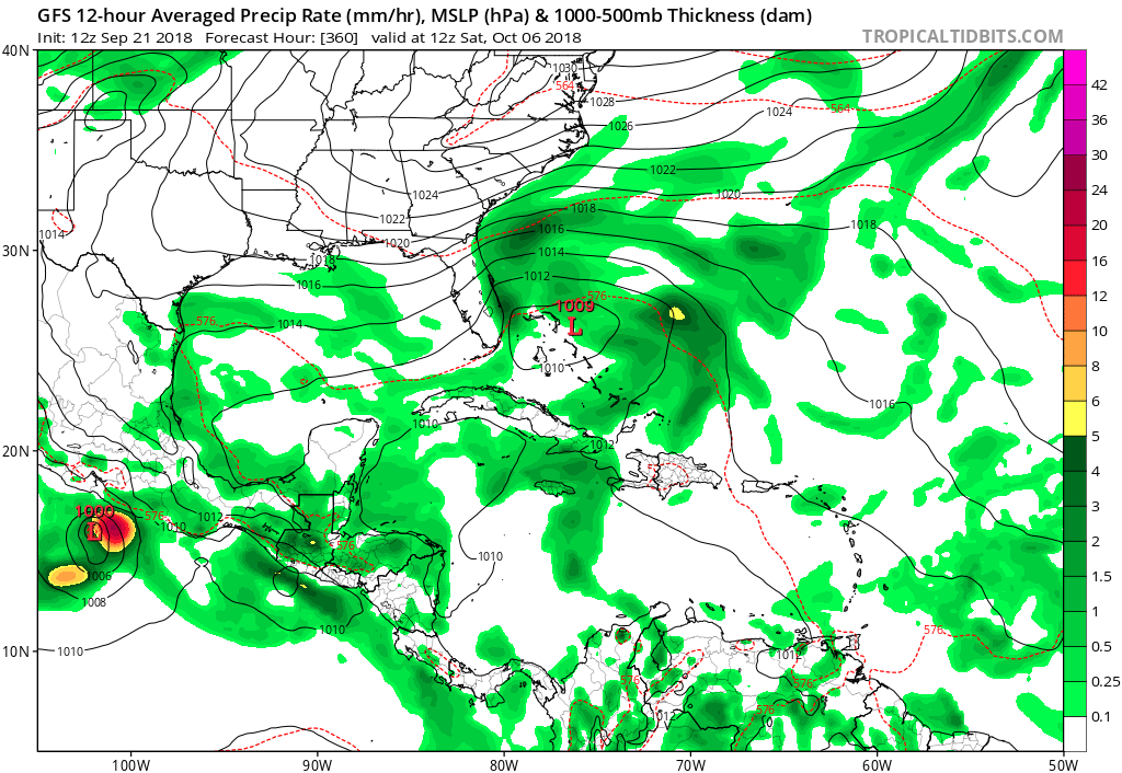
12Z GFS has this finding better conditions in the Bahamas in the long-range:
1 likes
Re: ATL: INVEST 99L - Models
The 12Z GFS keeps this weak and weakens it further to a ghost near PR before something apparently related to this redevelops in the Bahamas 10/5 before going up the E coast of FL as a TDish low on 10/7 below a stubborn and expansive NE US high. This exact solution is unimportant but this does give an idea of what this might do and when it might do it. So, for the SE US, whereas this doesn’t suggest betting on a threat, this does suggest to not bet the ranch on there being no TC threat around 10/7.
Edit: I see Gator posted about this while I was typing this.
Edit: I see Gator posted about this while I was typing this.
0 likes
Personal Forecast Disclaimer:
The posts in this forum are NOT official forecasts and should not be used as such. They are just the opinion of the poster and may or may not be backed by sound meteorological data. They are NOT endorsed by any professional institution or storm2k.org. For official information, please refer to the NHC and NWS products.
The posts in this forum are NOT official forecasts and should not be used as such. They are just the opinion of the poster and may or may not be backed by sound meteorological data. They are NOT endorsed by any professional institution or storm2k.org. For official information, please refer to the NHC and NWS products.
-
cycloneye
- Admin
- Posts: 139028
- Age: 67
- Joined: Thu Oct 10, 2002 10:54 am
- Location: San Juan, Puerto Rico
Re: ATL: INVEST 99L - Models
GFS tracks 99L to Florida.

0 likes
Visit the Caribbean-Central America Weather Thread where you can find at first post web cams,radars
and observations from Caribbean basin members Click Here
and observations from Caribbean basin members Click Here
-
Hurricaneman
- Category 5
- Posts: 7280
- Age: 43
- Joined: Tue Aug 31, 2004 3:24 pm
- Location: central florida
Re: ATL: INVEST 99L - Models
12zEuro puts this over Hispaniola/Cuba in 9 days, that would mean no development but we’ll have to wait a few more days before we’ll know where this will go
0 likes

-
Hurricaneman
- Category 5
- Posts: 7280
- Age: 43
- Joined: Tue Aug 31, 2004 3:24 pm
- Location: central florida
Re: ATL: INVEST 99L - Models
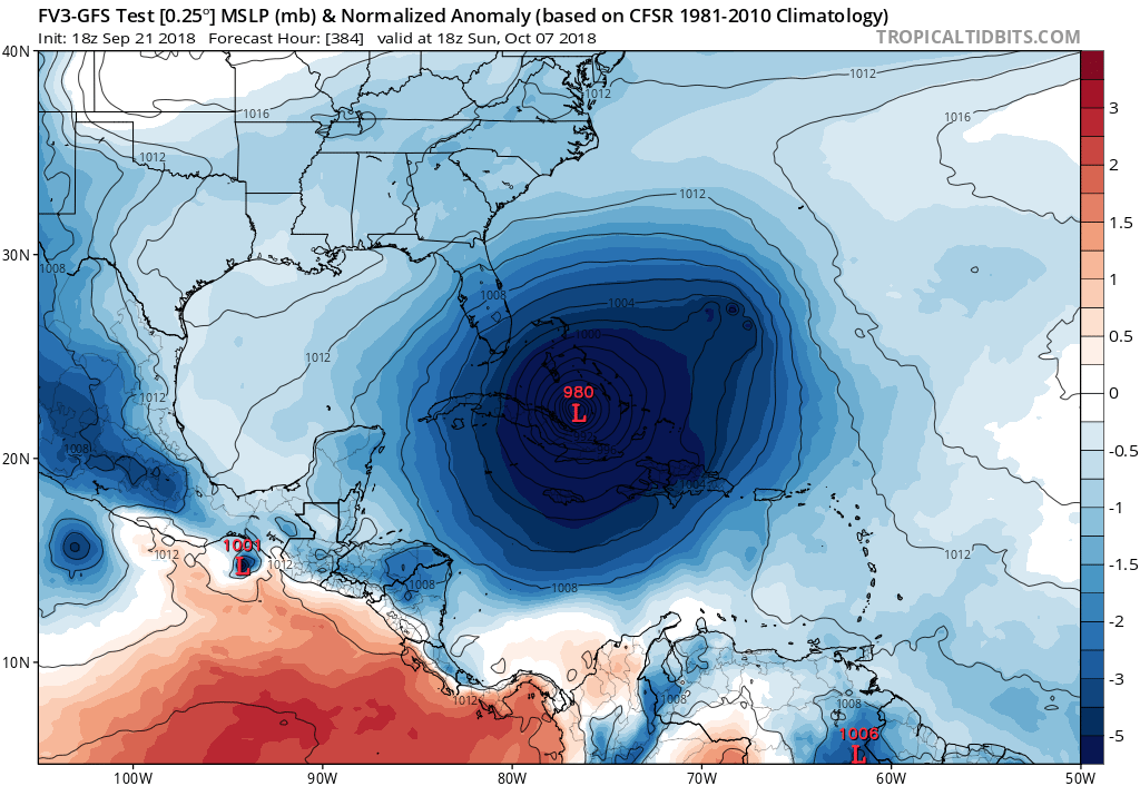
gatorcane wrote:FV3 GFS also redevelops in the Bahamas in the long-range:
https://i.postimg.cc/SNzx1JdK/fv3p_mslp_pcpn_watl_49.png
With that possible hurricane in the central Atlantic this probably will go north of the islands and may need to be watched in The Bahamas and SEUS as it will probably get propelled towards the coast by the ridge, it looks like the Euro and both versions of the GFS agree close on track into the Bahamas but the GFS both versions have it coming from the east while the Euro has it coming from the SE through Hispaniola and eastern Cuba
0 likes
Re: ATL: INVEST 99L - Models
gatorcane wrote:FV3 GFS also redevelops in the Bahamas in the long-range:
https://i.postimg.cc/SNzx1JdK/fv3p_mslp_pcpn_watl_49.png
Gator,
Is that definitely 99L in the Bahamas on the 12Z FV3? It almost looks like another low to its east comes out of S America on 10/1 that then goes to the Bahamas. Look real closely on the W Atlantic view:
Hour 210: 99L after skimming far N S America is a 1006 low heading W into the SW Caribbean:
https://www.tropicaltidbits.com/analysi ... atl_35.png
Hour 234: a new 1006 low to the east over far N S America that moves NW/NNW to the Bahamas: https://www.tropicaltidbits.com/analysi ... atl_39.png
0 likes
Personal Forecast Disclaimer:
The posts in this forum are NOT official forecasts and should not be used as such. They are just the opinion of the poster and may or may not be backed by sound meteorological data. They are NOT endorsed by any professional institution or storm2k.org. For official information, please refer to the NHC and NWS products.
The posts in this forum are NOT official forecasts and should not be used as such. They are just the opinion of the poster and may or may not be backed by sound meteorological data. They are NOT endorsed by any professional institution or storm2k.org. For official information, please refer to the NHC and NWS products.
-
gatorcane
- S2K Supporter
- Posts: 23499
- Age: 46
- Joined: Sun Mar 13, 2005 3:54 pm
- Location: Boca Raton, FL
Re: ATL: INVEST 99L - Models
LarryWx wrote:gatorcane wrote:FV3 GFS also redevelops in the Bahamas in the long-range:
https://i.postimg.cc/SNzx1JdK/fv3p_mslp_pcpn_watl_49.png
Gator,
Is that definitely 99L in the Bahamas on the 12Z FV3? It almost looks like another low to its east comes out of S America on 10/1 that then goes to the Bahamas. Look real closely on the W Atlantic view:
Hour 210: 99L after skimming far N S America is a 1006 low heading W into the SW Caribbean:
https://www.tropicaltidbits.com/analysi ... atl_35.png
Hour 234: a new 1006 low to the east over far N S America that moves NW/NNW to the Bahamas: https://www.tropicaltidbits.com/analysi ... atl_39.png
The 18Z FV3 seems to suggest what you noticed in that the remnants of 99l combine with some other low. Look how large the system is when the run ends:
0 likes
-
gatorcane
- S2K Supporter
- Posts: 23499
- Age: 46
- Joined: Sun Mar 13, 2005 3:54 pm
- Location: Boca Raton, FL
Re: ATL: INVEST 99L - Models
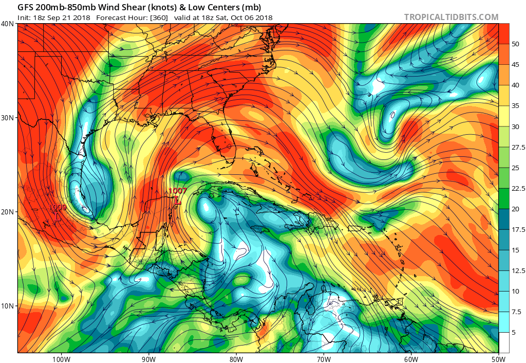
The GFS is also going with developing 99l in the Western Caribbean. Look at the large anti-cyclone. It doesn’t quite set this up right over 99l but it is close and had it been overtop would see much more develoment by the model. Of course this is super long-range:
0 likes
-
AnnularCane

- S2K Supporter
- Posts: 2634
- Joined: Thu Jun 08, 2006 9:18 am
- Location: Wytheville, VA
Re: ATL: INVEST 99L - Models
So 99L might struggle across the Atlantic and finally develop in the western Caribbean (and drive everyone nuts in the process)?
Sounds like classic 99L behavior.
Sounds like classic 99L behavior.
0 likes

Re: ATL: INVEST 99L - Models
gatorcane wrote:The GFS is also going with developing 99l in the Western Caribbean. Look at the large anti-cyclone. It doesn’t quite set this up right over 99l but it is close and had it been overtop would see much more develoment by the model. Of course this is super long-range:
[]https://i.postimg.cc/pLnZVd1m/gfs_shear_watl_51.png[/img]
Seems like a logical run. Many times we have seen W. Carribean development being triggered by a african wave serving as the spark. What I notice is the GFS and FV3 are more similar now on this scenario.
0 likes
The following post is NOT an official forecast and should not be used as such. It is just the opinion of the poster and may or may not be backed by sound meteorological data. It is NOT endorsed by any professional institution including storm2k.org For Official Information please refer to the NHC and NWS products.
-
Socalhurcnegirl227
- Category 1

- Posts: 267
- Age: 35
- Joined: Mon Jun 06, 2016 6:39 pm
- Location: Santa Barbara, CA
Re: ATL: INVEST 99L - Models
AnnularCane wrote:So 99L might struggle across the Atlantic and finally develop in the western Caribbean (and drive everyone nuts in the process)?
Sounds like classic 99L behavior.
1 likes
"I'm a wandress, i'm a one night stand,
dont belong to no city, dont belong to no man
i'm the violence in the pouring rain,
I'm a hurricane"
dont belong to no city, dont belong to no man
i'm the violence in the pouring rain,
I'm a hurricane"

Re: ATL: INVEST 99L - Models
GFS 06Z 9/22
Genesis in 36 hrs
Nice track to the islands
Crickets didn't last long, back to locusts

Genesis in 36 hrs
Nice track to the islands
Crickets didn't last long, back to locusts
1 likes
-
toad strangler

- S2K Supporter
- Posts: 4162
- Joined: Sun Jul 28, 2013 3:09 pm
- Location: Earth
- Contact:
Re: ATL: INVEST 99L - Models
gatorcane wrote:The GFS is also going with developing 99l in the Western Caribbean. Look at the large anti-cyclone. It doesn’t quite set this up right over 99l but it is close and had it been overtop would see much more develoment by the model. Of course this is super long-range:
JB obviously looking at the GFS tandem in the long range. Map on the left in this tweet.
https://twitter.com/BigJoeBastardi/status/1043488628444413952
0 likes
-
toad strangler
- S2K Supporter
- Posts: 4162
- Joined: Sun Jul 28, 2013 3:09 pm
- Location: Earth
- Contact:

Re: ATL: KIRK - Models
I think we need to see how the 12z models process this stronger system. I have not seen any of them show this strengthening in the short run. So it might be that it might now be able to survive longer.
0 likes
The following post is NOT an official forecast and should not be used as such. It is just the opinion of the poster and may or may not be backed by sound meteorological data. It is NOT endorsed by any professional institution including storm2k.org For Official Information please refer to the NHC and NWS products.
Re: ATL: KIRK - Models
12z is stronger so far in the short run so at least they have incorporated the new strengthening.
0 likes
The following post is NOT an official forecast and should not be used as such. It is just the opinion of the poster and may or may not be backed by sound meteorological data. It is NOT endorsed by any professional institution including storm2k.org For Official Information please refer to the NHC and NWS products.

Re: ATL: KIRK - Models
I would be amazed if Kirk made it across the Atlantic because of the weakness in the high to the north of the Antilles
0 likes
Who is online
Users browsing this forum: No registered users and 68 guests