EPAC: WILLA - Remnants

Moderator: S2k Moderators

Message
Author
hurricanes1234
Category 5
Category 5
Posts: 2903
Joined: Sat Jul 28, 2012 6:19 pm
Location: Trinidad and Tobago

Re: EPAC: WILLA - Hurricane

#161 Postby hurricanes1234 » Sun Oct 21, 2018 10:37 pm

Ntxw wrote:
hurricanes1234 wrote:I realise current hurricanes which resemble past hurricanes, tend to occur around the same date and in a similar fashion (I hope that's understandable as I'm not really sure how to describe it). :lol:

Yet, was it not 3 years ago, perhaps to the very day, that the world was watching a certain hurricane starting with the letter P, in a similar region and Mexico-bound as well, continue its explosive intensification during the nighttime hours, with recon being thrown in the mix as well? The similarities are simply mind-boggling. :eek:


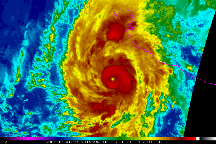
This is nowhere near the voracity of Patricia. But it is similar in the sense you labeled. Maybe not technically, but anecdotally you are looking at similar circumstances and evolution. Patricia just had higher fuel, this is maxing out the fuel that is given for this stamp in time.

Given how rapidly it intensified, and the tight, small core within a larger envelope, and trough nearby I just have a feeling the pressure gradient must be intense like Patricia or Linda condensed and compact. In my opinion, this is pretty much a Cat5.


Agreed, it's really the circumstances that are most similar since in terms of intensity, they differ enormously.
0 likes   
PLEASE NOTE: With the exception of information from weather agencies that I may copy and paste here, my posts will NEVER be official, since I am NOT a meteorologist. They are solely my amateur opinion, and may or may not be accurate. Therefore, please DO NOT use them as official details, particularly when making important decisions. Thank you.

User avatar
Cyclenall
Category 5
Category 5
Posts: 6627
Joined: Thu Jun 08, 2006 10:01 pm
Location: Ontario, Canada

Re: EPAC: WILLA - Hurricane

#162 Postby Cyclenall » Sun Oct 21, 2018 10:47 pm

The NHC isn't going with 140 knots, its always that 5 knot difference 98% of the time. Many of these high end hurricanes also seem to get stuck at 135 before either breaching the threshold or failing. Predictions on landfall intensity? Mine is 85 knots.

Some deeper convection is showing up in his CDO now. I think Willa will be stronger than Kenna but weaker than Rick.
0 likes   

Ntxw
Storm2k Moderator
Storm2k Moderator
Posts: 21501
Joined: Wed Oct 21, 2009 6:34 pm
Location: DFW, Texas

Re: EPAC: WILLA - Hurricane

#163 Postby Ntxw » Sun Oct 21, 2018 10:51 pm

Image
1 likes   
The above post and any post by Ntxw is NOT an official forecast and should not be used as such. It is just the opinion of the poster and may or may not be backed by sound meteorological data. It is NOT endorsed by any professional institution including Storm2k. For official information, please refer to NWS products.

  Help support Storm2K!
Help Support Storm2K

User avatar
Highteeld
Category 5
Category 5
Posts: 2097
Age: 40
Joined: Tue Jan 30, 2018 9:10 pm
Location: Chicago

Re: EPAC: WILLA - Hurricane

#164 Postby Highteeld » Sun Oct 21, 2018 11:16 pm

Still getting stronger. More pink on the northern side of the storm. CDO is getting better by the minute.

Image
2 likes   
Very useful information on the Dvorak Technique --

https://severe.worldweather.wmo.int/TCF ... kBeven.pdf

User avatar
EquusStorm
Category 5
Category 5
Posts: 1649
Age: 33
Joined: Thu Nov 07, 2013 1:04 pm
Location: Jasper, AL
Contact:

Re: EPAC: WILLA - Hurricane

#165 Postby EquusStorm » Sun Oct 21, 2018 11:17 pm

Doing that wobble we see all the time with pinhole eyes
0 likes   
Colors of lost purpose on the canvas of irrelevance

Not a meteorologist, in fact more of an idiot than anything. You should probably check with the NHC or a local NWS office for official information.

CryHavoc
Tropical Storm
Tropical Storm
Posts: 201
Age: 41
Joined: Thu Aug 24, 2017 5:18 pm
Location: Bay Area CA

Re: EPAC: WILLA - Hurricane

#166 Postby CryHavoc » Sun Oct 21, 2018 11:30 pm

Convection continuing to build and consolidate around the eye. Willa looks stronger than ever right now, and cloud tops are continuing to cool. I believe with nocturnal strengthening we might see a dawn of a Cat 5 hurricane.

Interesting to note that the CDO has actually shrank for most of the day as Willa increases in intensity. Wonder if this will reverse as it nears 157mph?
0 likes   

User avatar
Highteeld
Category 5
Category 5
Posts: 2097
Age: 40
Joined: Tue Jan 30, 2018 9:10 pm
Location: Chicago

Re: EPAC: WILLA - Hurricane

#167 Postby Highteeld » Sun Oct 21, 2018 11:46 pm

137.4 knots on ADT. Probably 140-145 with recon -- maybe getting to the 155 mark later tonight.

Image
0 likes   
Very useful information on the Dvorak Technique --

https://severe.worldweather.wmo.int/TCF ... kBeven.pdf

User avatar
1900hurricane
Category 5
Category 5
Posts: 6044
Age: 32
Joined: Fri Feb 06, 2015 12:04 pm
Location: Houston, TX
Contact:

Re: EPAC: WILLA - Hurricane

#168 Postby 1900hurricane » Mon Oct 22, 2018 12:04 am

Instantaneous DT is 7.5.
4 likes   
Contract Meteorologist. TAMU & MSST. Fiercely authentic, one of a kind. We are all given free will, so choose a life meant to be lived. We are the Masters of our own Stories.
Opinions expressed are mine alone.

Follow me on Twitter at @1900hurricane : Read blogs at https://1900hurricane.wordpress.com/

User avatar
EquusStorm
Category 5
Category 5
Posts: 1649
Age: 33
Joined: Thu Nov 07, 2013 1:04 pm
Location: Jasper, AL
Contact:

Re: EPAC: WILLA - Hurricane

#169 Postby EquusStorm » Mon Oct 22, 2018 12:11 am

I wanted to end the season with 300 ACE but Willa is getting a bit carried away doing that... eager to see what recon finds, but could weaken before then. Who knows.
0 likes   
Colors of lost purpose on the canvas of irrelevance

Not a meteorologist, in fact more of an idiot than anything. You should probably check with the NHC or a local NWS office for official information.

wx98
Category 5
Category 5
Posts: 1218
Joined: Sat Aug 25, 2018 9:24 pm

Re: EPAC: WILLA - Hurricane

#170 Postby wx98 » Mon Oct 22, 2018 12:40 am

BULLETIN
Hurricane Willa Intermediate Advisory Number 8A
NWS National Hurricane Center Miami FL EP242018
1200 AM MDT Mon Oct 22 2018

...WILLA RAPIDLY INTENSIFIES TO NEAR-CATEGORY 5 STRENGTH...
...EXPECTED TO PRODUCE LIFE-THREATENING STORM SURGE, WIND, AND
RAINFALL OVER PORTIONS OF WEST-CENTRAL AND SOUTHWESTERN MEXICO...


SUMMARY OF 1200 AM MDT...0600 UTC...INFORMATION
-----------------------------------------------
LOCATION...17.9N 107.1W
ABOUT 195 MI...315 KM SSW OF CABO CORRIENTES MEXICO
MAXIMUM SUSTAINED WINDS...155 MPH...250 KM/H
PRESENT MOVEMENT...N OR 360 DEGREES AT 5 MPH...7 KM/H
MINIMUM CENTRAL PRESSURE...931 MB...27.49 INCHES


WATCHES AND WARNINGS
--------------------
CHANGES WITH THIS ADVISORY:

None.

SUMMARY OF WATCHES AND WARNINGS IN EFFECT:

A Hurricane Warning is in effect for...
* San Blas to Mazatlan, including Las Islas Marias

A Tropical Storm Warning is in effect for...
* Playa Perula to San Blas
* North of Mazatlan to Bahia Tempehuaya

A Hurricane Warning means that hurricane conditions are expected
somewhere within the warning area. A warning is typically issued
36 hours before the anticipated first occurrence of
tropical-storm-force winds, conditions that make outside
preparations difficult or dangerous. Preparations to protect life
and property should be rushed to completion.

A Tropical Storm Warning means that tropical storm conditions are
expected somewhere within the warning area within 36 hours.

Interests elsewhere along the coasts of west-central and
southwestern mainland Mexico should monitor the progress of Willa.

For storm information specific to your area, please monitor
products issued by your national meteorological service.


DISCUSSION AND OUTLOOK
----------------------
At 1200 AM MDT (0600 UTC), the eye of Hurricane Willa was located
near latitude 17.9 North, longitude 107.1 West. Willa is moving
toward the north near 5 mph (7 km/h), and this general motion is
expected to continue today. Willa is forecast to accelerate toward
the north-northeast and move over or very near the Islas Marias on
Tuesday and make landfall along the southwestern coast of mainland
Mexico in the hurricane warning area Tuesday night or Wednesday
morning.

Maximum sustained winds have increased to near 155 mph (250 km/h)
with higher gusts. Willa is an extremely dangerous category 4
hurricane on the Saffir-Simpson Hurricane Wind Scale. Additional
strengthening is expected today, and Willa could become a category
5 hurricane later this morning. While some weakening is forecast by
tonight and Tuesday, Willa is expected to be a dangerous hurricane
when it reaches the coast of Mexico late Tuesday or early Wednesday.

Hurricane-force winds extend outward up to 25 miles (35 km) from
the center and tropical-storm-force winds extend outward up to 90
miles (150 km).

The estimated minimum central pressure is 931 mb (27.49 inches).


HAZARDS AFFECTING LAND
----------------------
STORM SURGE: A dangerous storm surge is likely along portions of
the coast of southwestern Mexico by Tuesday or Tuesday night,
especially near and to the south of where the center of Willa makes
landfall. Near the coast, the surge will be accompanied by large and
destructive waves.

RAINFALL: Willa is expected to produce storm total rainfall
accumulations of 6 to 12 inches, with local amounts to 18 inches,
across portions of western Jalisco, western Nayarit, and southern
Sinaloa in Mexico. This rainfall will cause life-threatening flash
flooding and landslides.

Farther inland, Willa is expected to produce rainfall amount of 2 to
4 inches across portions of Zacateca, Durango, southeast Chihuahua,
and Coahuila in Mexico, with local amounts to 6 inches possible.
This rainfall could cause life-threatening flash flooding.

WIND: Hurricane conditions are expected within the hurricane
warning area by late Tuesday, with tropical storm conditions
expected by Tuesday morning. Tropical storm conditions are expected
within the tropical storm warning areas tonight and Tuesday.

SURF: Large swells generated by Willa will continue to affect
portions of the coast of southwestern and west-central Mexico
during the next few days. These swells are likely to cause
life-threatening surf and rip current conditions. Please consult
products from your local weather office.


NEXT ADVISORY
-------------
Next complete advisory at 300 AM MDT.

$$
Forecaster Stewart
0 likes   

User avatar
Cyclenall
Category 5
Category 5
Posts: 6627
Joined: Thu Jun 08, 2006 10:01 pm
Location: Ontario, Canada

Re: EPAC: WILLA - Hurricane

#171 Postby Cyclenall » Mon Oct 22, 2018 12:46 am

I didn't expect Willa's structure to look like this 7 hours ago, now I'm intrigued to see how that shapes up. I think he's at 140 right now, maybe a 155 is possible for him. This season is just loaded with absurd statistics.
1 likes   

User avatar
EquusStorm
Category 5
Category 5
Posts: 1649
Age: 33
Joined: Thu Nov 07, 2013 1:04 pm
Location: Jasper, AL
Contact:

Re: EPAC: WILLA - Hurricane

#172 Postby EquusStorm » Mon Oct 22, 2018 12:55 am

October is a month to absolutely be feared in the tropics, really in any Northern Hemisphere basin... quantity not so much, but when they do happen, big yikes
6 likes   
Colors of lost purpose on the canvas of irrelevance

Not a meteorologist, in fact more of an idiot than anything. You should probably check with the NHC or a local NWS office for official information.

User avatar
Yellow Evan
Professional-Met
Professional-Met
Posts: 15951
Age: 25
Joined: Fri Jul 15, 2011 12:48 pm
Location: Henderson, Nevada/Honolulu, HI
Contact:

Re: EPAC: WILLA - Hurricane

#173 Postby Yellow Evan » Mon Oct 22, 2018 1:16 am

Image

T7.0.
0 likes   

User avatar
Yellow Evan
Professional-Met
Professional-Met
Posts: 15951
Age: 25
Joined: Fri Jul 15, 2011 12:48 pm
Location: Henderson, Nevada/Honolulu, HI
Contact:

Re: EPAC: WILLA - Hurricane

#174 Postby Yellow Evan » Mon Oct 22, 2018 1:17 am

----- Current Analysis -----
Date : 22 OCT 2018 Time : 051537 UTC
Lat : 17:49:11 N Lon : 107:04:48 W


CI# /Pressure/ Vmax
6.9 / 926.6mb/137.4kt


Final T# Adj T# Raw T#
6.9 7.1 7.1

Estimated radius of max. wind based on IR : 13 km

Center Temp : +14.9C Cloud Region Temp : -73.4C

Scene Type : EYE
0 likes   

User avatar
Yellow Evan
Professional-Met
Professional-Met
Posts: 15951
Age: 25
Joined: Fri Jul 15, 2011 12:48 pm
Location: Henderson, Nevada/Honolulu, HI
Contact:

Re: EPAC: WILLA - Hurricane

#175 Postby Yellow Evan » Mon Oct 22, 2018 2:17 am

EP, 24, 201810220545, 10, DVTS, CI, , 1790N, 10710W, , 1, 127, 2, 935, 2, DVRK, , , , , , , , , , , , , 15, E, TAFB, MN, I, 1, 6565 /////, , , GOES16, CSC, T, AODT RAW 7.1 AT 0515Z
0 likes   

User avatar
Yellow Evan
Professional-Met
Professional-Met
Posts: 15951
Age: 25
Joined: Fri Jul 15, 2011 12:48 pm
Location: Henderson, Nevada/Honolulu, HI
Contact:

Re: EPAC: WILLA - Hurricane

#176 Postby Yellow Evan » Mon Oct 22, 2018 2:18 am

22/0600 UTC 17.9N 106.9W T6.5/6.5 WILLA -- East Pacific
0 likes   

User avatar
Yellow Evan
Professional-Met
Professional-Met
Posts: 15951
Age: 25
Joined: Fri Jul 15, 2011 12:48 pm
Location: Henderson, Nevada/Honolulu, HI
Contact:

Re: EPAC: WILLA - Hurricane

#177 Postby Yellow Evan » Mon Oct 22, 2018 2:19 am

EP, 24, 2018102206, , BEST, 0, 179N, 1071W, 135, 931, HU, 34, NEQ, 80, 80, 60, 70, 1009, 180, 10, 0, 0, E, 0, , 0, 0, WILLA, D, 0, , 0, 0, 0, 0, genesis-num, 040,
0 likes   

HurricaneRyan
Category 2
Category 2
Posts: 712
Age: 30
Joined: Sun Dec 05, 2010 3:05 pm

Re: EPAC: WILLA - Hurricane

#178 Postby HurricaneRyan » Mon Oct 22, 2018 2:26 am

No one is going to get my Willa Ford references, but Willa is shaping up to be a very nice storm.
0 likes   
Kay '22 Hilary '23

User avatar
cycloneye
Admin
Admin
Posts: 139069
Age: 67
Joined: Thu Oct 10, 2002 10:54 am
Location: San Juan, Puerto Rico

Re: EPAC: WILLA - Hurricane

#179 Postby cycloneye » Mon Oct 22, 2018 5:11 am

Hurricane Willa Discussion Number 9
NWS National Hurricane Center Miami FL EP242018
300 AM MDT Mon Oct 22 2018

Willa is an impressive hurricane with rapid to explosive deepening
having occurred over the past 48 hours, and yielding a 105-kt
intensity increase during that time. Satellite intensity estimates
range from subjective Dvorak T-numbers of T6.5/127 kt from TAFB and
SAB to objective T-numbers of T7.0/140 kt from UW-CIMSS ADT and NHC.
The most recent UW-CIMSS SATCON value around 0437Z was 127 kt. Based
on these data and the slightly more ragged appearance of the CDO
over the past couple of hours, the intensity is raised to 135 kt,
which is just below category 5 strength.

Willa is now moving northward and the initial motion estimate is
360/06 kt. Willa is forecast to continue moving northward today as
the hurricane rounds the western portion of a deep-layer ridge
located over central Mexico and which extends westward along 20N
latitude to near the Pacific coast of Mexico. On Tuesday, a turn
toward the north-northeast and northeast at a slightly faster
forward speed is expected as the hurricane gets caught up in
southwesterly flow ahead of an approaching mid-/upper-level trough.
The latest 00Z NHC model guidance is in decent agreement on this
general track scenario, but with noticeable differences in the
forward speed. Internal statistical analyses show that the ECMWF
and UKMET models have had a slow westward bias over the past 48
hours, which has significantly affected the consensus models. As a
result, the new NHC forecast is a little to the right of and
slightly faster the previous advisory track and the consensus
models, and lies close to GFS model which has verified the best
thus far. On the forecast track, Willa is expected to move over Las
Islas Marias on Tuesday and then move inland over southwestern and
west-central Mexico Tuesday night or early Wednesday. A 72-hour
position has been provided only for continuity purposes beyond the
48-hour period, and Willa will likely have dissipated by then.

Water temperatures ahead of the powerful hurricane are forecast to
increase from 28 deg C to near 29.5 deg C, and the depth of the warm
water is also expected to increase, which would tend to offset any
cold upwelling beneath Willa. The deep-layer shear is forecast to
increase to a little more than 10 kt during the next 36 hours, and
remain at that level during the duration of that time period. These
conditions would favor at least slight strengthening before the
internal dynamics of the hurricane in the form of an eyewall
replacement cycle (ERC) induces some weakening. With the eye
diameter already at 10-15 nmi, an ERC could begin at any time
during the next 12 hours. Shortly after 36 hours, the shear is
expected to increase sharply to more than 20 kt, which will cause
more significant weakening. However, Willa is still expected to be
near major hurricane strength when it makes landfall along the
west-central coast of Mexico. After landfall, the mountainous
terrain along with strong southwesterly wind shear of more than 30
kt will cause rapid weakening and dissipation of the cyclone inland
over north-central Mexico.

Key Messages:

1. Willa is forecast to be a dangerous hurricane when it reaches the
Islas Marias and the coast of southwestern Mexico by late Tuesday or
Wednesday morning, bringing a life-threatening storm surge and flash
flooding along with damaging hurricane-force winds. A Hurricane
Warning is in effect for these areas, and residents should rush
preparations to completion to protect life and property and follow
any advice given by local officials.


FORECAST POSITIONS AND MAX WINDS

INIT 22/0900Z 18.2N 107.1W 135 KT 155 MPH
12H 22/1800Z 19.2N 107.2W 135 KT 155 MPH
24H 23/0600Z 20.4N 107.2W 125 KT 145 MPH
36H 23/1800Z 21.8N 106.5W 115 KT 130 MPH
48H 24/0600Z 23.8N 104.6W 50 KT 60 MPH...INLAND WNCTRL MEXICO
72H 25/0600Z 27.0N 99.5W 20 KT 25 MPH...POST-TROP/INLAND
96H 26/0600Z...DISSIPATED INLAND

$$
Forecaster Stewart
0 likes   
Visit the Caribbean-Central America Weather Thread where you can find at first post web cams,radars
and observations from Caribbean basin members Click Here

Chris90
Category 2
Category 2
Posts: 637
Age: 34
Joined: Thu Jun 01, 2017 9:36 pm

Re: EPAC: WILLA - Hurricane

#180 Postby Chris90 » Mon Oct 22, 2018 5:37 am

HurricaneRyan wrote:No one is going to get my Willa Ford references, but Willa is shaping up to be a very nice storm.


Not true. Willa very clearly wants to be bad.
0 likes   


Return to “2018”

Who is online

Users browsing this forum: No registered users and 93 guests