EPAC: KIKO - Post-Tropical

Moderator: S2k Moderators

Message
Author
User avatar
cycloneye
Admin
Admin
Posts: 139070
Age: 67
Joined: Thu Oct 10, 2002 10:54 am
Location: San Juan, Puerto Rico

Re: EPAC: KIKO - Hurricane

#81 Postby cycloneye » Mon Sep 16, 2019 9:57 am

Hurricane Kiko Discussion Number 17
NWS National Hurricane Center Miami FL EP132019
800 AM PDT Mon Sep 16 2019

Microwave data and satellite imagery continue to indicate that the
core of Kiko is being disrupted. While there is a seemingly
favorable outflow pattern, northeasterly shear is undercutting the
top layer and preventing the cyclone from having a closed eyewall.
Satellite estimates are falling and support a perhaps-generous
initial wind speed of 90 kt.

The shear is forecast to continue during the next day or so, which
should promote further weakening. After that time, the shear could
lessen, although the environment overall is hardly very conducive
for strengthening, and this scenario would best support little
change in intensity. By Friday-Saturday, model guidance does show an
increase in shear, so a more notable weakening could occur. The new
NHC intensity forecast is reduced from the previous one, following
the trend in the guidance, but is a bit above the model consensus. A
fair number of models actually show a weaker cyclone, but in a
complex environment, I'd rather be conservative in changing the
longer-range intensity forecast.

There's no significant track change to report with Kiko. The
hurricane is moving westward at 4 kt, to the south of a weak
mid-level ridge. By 36 hours, another ridge building to the
northwest of the hurricane will begin to steer Kiko to the
west-southwest. This ridge is then forecast to weaken by 72 hours,
while subtropical ridging builds to the north and northeast of the
cyclone. This will likely result in a general westward to
west-northwestward track through the end of the forecast period.
The new forecast track is close to the previous one, on the faster
and southern side of the guidance, which has generally been the
right place to be with Kiko's track.

FORECAST POSITIONS AND MAX WINDS

INIT 16/1500Z 17.3N 123.7W 90 KT 105 MPH
12H 17/0000Z 17.3N 124.3W 80 KT 90 MPH
24H 17/1200Z 17.2N 125.1W 70 KT 80 MPH
36H 18/0000Z 16.9N 126.0W 65 KT 75 MPH
48H 18/1200Z 16.7N 127.0W 60 KT 70 MPH
72H 19/1200Z 16.9N 129.1W 60 KT 70 MPH
96H 20/1200Z 17.3N 130.7W 55 KT 65 MPH
120H 21/1200Z 17.3N 132.5W 45 KT 50 MPH

$$
Forecaster Blake
0 likes   
Visit the Caribbean-Central America Weather Thread where you can find at first post web cams,radars
and observations from Caribbean basin members Click Here

User avatar
Yellow Evan
Professional-Met
Professional-Met
Posts: 15951
Age: 25
Joined: Fri Jul 15, 2011 12:48 pm
Location: Henderson, Nevada/Honolulu, HI
Contact:

Re: EPAC: KIKO - Hurricane

#82 Postby Yellow Evan » Mon Sep 16, 2019 2:04 pm

12z GFS keeps Kiko around for the entire 16 days mostly stalled out in the 130-135W area.
0 likes   

User avatar
Kingarabian
S2K Supporter
S2K Supporter
Posts: 15434
Joined: Sat Aug 08, 2009 3:06 am
Location: Honolulu, Hawaii

Re: EPAC: KIKO - Hurricane

#83 Postby Kingarabian » Mon Sep 16, 2019 3:13 pm

Yellow Evan wrote:12z GFS keeps Kiko around for the entire 16 days mostly stalled out in the 130-135W area.

12z Euro keeps it around for 10 days as well but much stronger compared to the GFS.
0 likes   
RIP Kobe Bryant

User avatar
cycloneye
Admin
Admin
Posts: 139070
Age: 67
Joined: Thu Oct 10, 2002 10:54 am
Location: San Juan, Puerto Rico

Re: EPAC: KIKO - Hurricane

#84 Postby cycloneye » Mon Sep 16, 2019 3:41 pm

Hurricane Kiko Discussion Number 18
NWS National Hurricane Center Miami FL EP132019
200 PM PDT Mon Sep 16 2019

There hasn't been a lot of change in Kiko during the day, with the
cyclone keeping a small central core and no hints of an eye
feature. While there is plenty of outflow, the sharp edge in the
cirrus canopy on the north side is indicative of the maintenance of
northeasterly shear. Intensity estimates are lower than this
morning, and the initial wind speed is reduced to 85 kt. Weakening
is anticipated during the next day or so as the shear continues.
The forecast is more complicated after that time since the track
keeps adjusting southward over warmer water while the shear relaxes.
This change results in some models showing re-intensification in a
few days, although that's temporary since the shear is forecast to
resume at long range. To account for this scenario, the new
forecast shows a small bump up in intensity for later this week, and
we will just have to see how far south Kiko makes it before making a
more significant increase in winds.

Kiko continues to move westward at 4 kt to the south of a weak mid-
level ridge. The hurricane is forecast to turn to the west-
southwest by tomorrow due to a mid-level ridge building in from the
central Pacific. This ridge is then forecast to weaken by 72 hours,
while subtropical ridging builds to the north and northeast of the
cyclone. This should result in a general westward to west-
northwestward track through the end of the forecast period. The
majority in the models are south of their previous tracks, starting
the south-of-west motion as early as tonight. Thus the new forecast
is adjusted south of the last NHC prediction, and this is not a
particularly confident situation due to the unsteadiness of most of
the guidance.


FORECAST POSITIONS AND MAX WINDS

INIT 16/2100Z 17.3N 124.1W 85 KT 100 MPH
12H 17/0600Z 17.1N 124.7W 75 KT 85 MPH
24H 17/1800Z 16.8N 125.5W 65 KT 75 MPH
36H 18/0600Z 16.6N 126.4W 55 KT 65 MPH
48H 18/1800Z 16.6N 127.5W 55 KT 65 MPH
72H 19/1800Z 17.0N 129.7W 60 KT 70 MPH
96H 20/1800Z 17.3N 130.7W 50 KT 60 MPH
120H 21/1800Z 17.3N 132.0W 40 KT 45 MPH

$$
Forecaster Blake
0 likes   
Visit the Caribbean-Central America Weather Thread where you can find at first post web cams,radars
and observations from Caribbean basin members Click Here

Astromanía
Category 2
Category 2
Posts: 737
Age: 25
Joined: Sat Aug 25, 2018 10:34 pm
Location: Monterrey, N.L, México

Re: EPAC: KIKO - Hurricane

#85 Postby Astromanía » Mon Sep 16, 2019 4:17 pm

Kiko its not done yet, still bringing ACE to the season and expecting to have a long life with a possibility of a reintensification
1 likes   

User avatar
cycloneye
Admin
Admin
Posts: 139070
Age: 67
Joined: Thu Oct 10, 2002 10:54 am
Location: San Juan, Puerto Rico

Re: EPAC: KIKO - Hurricane

#86 Postby cycloneye » Mon Sep 16, 2019 9:50 pm

Hurricane Kiko Discussion Number 19
NWS National Hurricane Center Miami FL EP132019
800 PM PDT Mon Sep 16 2019

Kiko continues to gradually lose strength. Satellite images show
a less organized central dense overcast feature with no evidence of
an eye. There is a sharp edge in the convective pattern on the
north side of the system, suggestive of continued northerly wind
shear. The initial wind speed is lowered to 75 kt, which is near
the high end of the latest satellite intensity estimates. Kiko
remains a very compact system with its tropical-storm-force winds
and rain bands extending only about 50 n mi from the center.

Additional weakening seems likely during the next 24 hours due to
the continued effects of northerly shear, dry air, and marginally
warm SSTs, and the NHC forecast shows Kiko falling below hurricane
intensity during that time. The models show Kiko re-strengthening
a little or maintaining its intensity on Wednesday and Thursday as
it moves over slightly warmer waters and into a region of lower
shear. However, weakening should resume by the end of the week
when the cyclone moves into a less favorable atmospheric
environment. The NHC intensity forecast follows the trend of the
guidance and is in best agreement with the intensity consensus aids.

Kiko continues to only crawl westward in relatively weak steering
currents. A ridge building to the northwest of Kiko over the
central Pacific is forecast to steer the cyclone west-southwestward
on Tuesday and Wednesday. After that time, the ridge is expected to
weaken allowing Kiko to turn westward or west-northwestward later
this week, followed by another turn to the southwest by the end of
the forecast period. Regardless of the details of the track
forecast, the bottom line is that Kiko is expected to continue its
slow trek for several more days.


FORECAST POSITIONS AND MAX WINDS

INIT 17/0300Z 17.2N 124.4W 75 KT 85 MPH
12H 17/1200Z 17.0N 124.9W 65 KT 75 MPH
24H 18/0000Z 16.7N 125.9W 55 KT 65 MPH
36H 18/1200Z 16.5N 126.8W 55 KT 65 MPH
48H 19/0000Z 16.6N 128.0W 60 KT 70 MPH
72H 20/0000Z 17.2N 129.8W 60 KT 70 MPH
96H 21/0000Z 17.7N 130.7W 45 KT 50 MPH
120H 22/0000Z 17.2N 132.0W 40 KT 45 MPH

$$
Forecaster Cangialosi
0 likes   
Visit the Caribbean-Central America Weather Thread where you can find at first post web cams,radars
and observations from Caribbean basin members Click Here

User avatar
cycloneye
Admin
Admin
Posts: 139070
Age: 67
Joined: Thu Oct 10, 2002 10:54 am
Location: San Juan, Puerto Rico

Re: EPAC: KIKO - Hurricane

#87 Postby cycloneye » Tue Sep 17, 2019 5:21 am

Hurricane Kiko Discussion Number 20
NWS National Hurricane Center Miami FL EP132019
200 AM PDT Tue Sep 17 2019

The northeasterly shear impacting Kiko has still not let up.
Satellite imagery shows an irregular shaped central dense overcast
with the anvils being forced downshear. A blend of the latest
subjective and objective intensity estimates suggest the initial
intensity has decreased to 70 kt, and this value may be a little
generous based on a recent scatterometer pass.

Kiko is moving slowly westward. All of the track guidance indicate
that a turn to the west-southwest should be commencing very soon as
the cyclone becomes steered by a mid-level ridge to its northwest.
This steering pattern should remain in place for the next couple of
days, before the ridge weakens and Kiko becomes steered to the west
to west-northwest by a ridge to its northeast. Late in the forecast
period, a new ridge should develop to the northwest of Kiko, causing
another turn to the west-southwest. All the while, the steering
currents will be fairly weak, resulting in a slow forward motion
for the next several days. The official NHC forecast was adjusted
only slightly to the south through 72 hours due to a shift in the
consensus aids.

The shear is expected to weaken Kiko to a tropical storm later
today. By tonight, this shear is expected to diminish, which could
allow for some re-strengthening. However, moderately stable air
surrounding the system, subsidence from the ridge to the northwest,
and marginal sea surface temperatures should keep the strengthening
at a minimum before the shear returns in a couple of days. This
re-strengthening is forecast by most of the guidance, and although
the NHC forecast makes Kiko a hurricane again, the forecast
intensity is a little lower than some of the most reliable consensus
aids during that time period. Once the shear returns, Kiko is
expected to begin weakening once again and should become a tropical
storm by 72 hours.

FORECAST POSITIONS AND MAX WINDS

INIT 17/0900Z 17.2N 124.7W 70 KT 80 MPH
12H 17/1800Z 16.9N 125.3W 60 KT 70 MPH
24H 18/0600Z 16.7N 126.3W 55 KT 65 MPH
36H 18/1800Z 16.6N 127.3W 60 KT 70 MPH
48H 19/0600Z 16.8N 128.5W 65 KT 75 MPH
72H 20/0600Z 17.5N 129.9W 55 KT 65 MPH
96H 21/0600Z 17.7N 131.0W 50 KT 60 MPH
120H 22/0600Z 17.0N 132.5W 45 KT 50 MPH

$$
Forecaster Latto
0 likes   
Visit the Caribbean-Central America Weather Thread where you can find at first post web cams,radars
and observations from Caribbean basin members Click Here

User avatar
cycloneye
Admin
Admin
Posts: 139070
Age: 67
Joined: Thu Oct 10, 2002 10:54 am
Location: San Juan, Puerto Rico

Re: EPAC: KIKO - Tropical Storm

#88 Postby cycloneye » Tue Sep 17, 2019 4:18 pm

Tropical Storm Kiko Discussion Number 22
NWS National Hurricane Center Miami FL EP132019
200 PM PDT Tue Sep 17 2019

Convection has been struggling near the center of Kiko today, with
only some re-development near the core of the cyclone during the
past couple of hours. There's a pretty big disparity in the
initial wind speed estimates this afternoon. Recent ASCAT data
supports 40-45 kt, while other estimates are still near hurricane-
force. Weighing the scatterometer data heavier than most gives an
initial intensity of 50 kt for this advisory.

Kiko is on track toward the west-southwest, steered by a ridge
extending from the central Pacific. The forecast continues to
shift to the south with time, with a stronger ridge anticipated,
and the model guidance is more consistent in showing two west-
southwestward dips, one at the current time and one after day 5. The
new NHC track prediction is somewhat south of the previous one, but
this time it is fairly close to the model consensus, hopefully
indicating that the southward shifts are done for the time being.

While the current shear near Kiko should relax later today, it
could take some time before the storm can recover from the
effects of the shear. Kiko will probably to re-strengthen in a day
or so, in part due to the cyclone moving over warmer waters in a
low-shear environment. Afterward, there is very little agreement on
the long-range upper-level wind forecast, leading to wildly
divergent intensity forecasts by day 5 in the models, ranging from a
tropical depression to a category 4 hurricane. For now since the
track forecast brings Kiko again over warmer waters, a slight
increase in wind speed is shown, and this could be conservative at
the end of the 5-day period.


FORECAST POSITIONS AND MAX WINDS

INIT 17/2100Z 16.8N 125.1W 50 KT 60 MPH
12H 18/0600Z 16.4N 125.8W 50 KT 60 MPH
24H 18/1800Z 16.2N 126.8W 50 KT 60 MPH
36H 19/0600Z 16.1N 127.9W 55 KT 65 MPH
48H 19/1800Z 16.5N 128.9W 60 KT 70 MPH
72H 20/1800Z 17.0N 130.1W 65 KT 75 MPH
96H 21/1800Z 17.0N 131.0W 60 KT 70 MPH
120H 22/1800Z 16.0N 133.5W 65 KT 75 MPH

$$
Forecaster Blake
0 likes   
Visit the Caribbean-Central America Weather Thread where you can find at first post web cams,radars
and observations from Caribbean basin members Click Here

Astromanía
Category 2
Category 2
Posts: 737
Age: 25
Joined: Sat Aug 25, 2018 10:34 pm
Location: Monterrey, N.L, México

Re: EPAC: KIKO - Tropical Storm

#89 Postby Astromanía » Tue Sep 17, 2019 5:51 pm

Come on Kiko! bring back that cat 4! Bring more ACE!
0 likes   

Astromanía
Category 2
Category 2
Posts: 737
Age: 25
Joined: Sat Aug 25, 2018 10:34 pm
Location: Monterrey, N.L, México

Re: EPAC: KIKO - Tropical Storm

#90 Postby Astromanía » Wed Sep 18, 2019 12:11 am

Maybe its time for Kiko's comeback, convection increasing now
Image
0 likes   

User avatar
Yellow Evan
Professional-Met
Professional-Met
Posts: 15951
Age: 25
Joined: Fri Jul 15, 2011 12:48 pm
Location: Henderson, Nevada/Honolulu, HI
Contact:

Re: EPAC: KIKO - Tropical Storm

#91 Postby Yellow Evan » Wed Sep 18, 2019 1:17 am

ECMWF, HWRF, and HMON all quite bullish with this. We should get a Category 1-2 again at least, with room for even higher.
1 likes   

wx98
Category 5
Category 5
Posts: 1218
Joined: Sat Aug 25, 2018 9:24 pm

Re: EPAC: KIKO - Tropical Storm

#92 Postby wx98 » Wed Sep 18, 2019 10:08 am

...KIKO MOVING OVER WARMER WATER AND STRENGTHENING...
8:00 AM PDT Wed Sep 18
Location: 16.0°N 126.7°W
Moving: WSW at 6 mph
Min pressure: 1001 mb
Max sustained: 60 mph


It’s back on the upswing 8-)
0 likes   

User avatar
Yellow Evan
Professional-Met
Professional-Met
Posts: 15951
Age: 25
Joined: Fri Jul 15, 2011 12:48 pm
Location: Henderson, Nevada/Honolulu, HI
Contact:

Re: EPAC: KIKO - Tropical Storm

#93 Postby Yellow Evan » Wed Sep 18, 2019 11:34 am

ZCZC MIATCDEP3 ALL
TTAA00 KNHC DDHHMM

Tropical Storm Kiko Discussion Number 24
NWS National Hurricane Center Miami FL EP132019
200 AM PDT Wed Sep 18 2019

Kiko is trying to recover from all of the shear that affected it
for the past few days. An earlier microwave pass showed that most of
the convection was confined to the southern semicircle. Over the
past few hours, deep convection has been looking a little more
organized near the storm's center. Whether or not this is the start
of a trend is too early to tell, and a blend of the subjective and
objective intensity estimates indicate that the initial intensity
remains near 45 kt.

Kiko continues to move southwest, or 240/04 kt. There is no change
to the forecast track philosophy. Kiko will be steered in a mean
westerly trajectory for the next several days by mid-level ridging
to the north of the cyclone. Some northward or southward deviations
in the forward motion are expected from time to time due to
fluctuations in the strength of the ridge. The official forecast is
very close to the previous one, and near the multi-model track
consensus aids.

Kiko is expected to remain in a low shear environment and will soon
will be moving over higher oceanic heat content. This should result
in gradual strengthening. In a few days, the cyclone will begin to
move into a drier and more stable environment which should limit
any further intensification during the forecast period. The latest
forecast is essentially an update of the previous one, and is near
the corrected consensus HCCA.


FORECAST POSITIONS AND MAX WINDS

INIT 18/0900Z 16.5N 125.9W 45 KT 50 MPH
12H 18/1800Z 16.2N 126.7W 45 KT 50 MPH
24H 19/0600Z 16.1N 127.7W 50 KT 60 MPH
36H 19/1800Z 16.3N 128.5W 55 KT 65 MPH
48H 20/0600Z 16.6N 129.1W 60 KT 70 MPH
72H 21/0600Z 17.2N 130.4W 70 KT 80 MPH
96H 22/0600Z 16.7N 132.4W 70 KT 80 MPH
120H 23/0600Z 16.0N 135.0W 70 KT 80 MPH

$$
Forecaster Latto
0 likes   

User avatar
Yellow Evan
Professional-Met
Professional-Met
Posts: 15951
Age: 25
Joined: Fri Jul 15, 2011 12:48 pm
Location: Henderson, Nevada/Honolulu, HI
Contact:

Re: EPAC: KIKO - Tropical Storm

#94 Postby Yellow Evan » Wed Sep 18, 2019 11:35 am

ZCZC MIATCDEP3 ALL
TTAA00 KNHC DDHHMM

Tropical Storm Kiko Discussion Number 25
NWS National Hurricane Center Miami FL EP132019
800 AM PDT Wed Sep 18 2019

Kiko appears to be stronger this morning with very deep convection
near the center, although the cloud pattern is somewhat distorted.
The initial wind speed is conservatively raised to 50 kt on this
advisory, since the subjective satellite estimates have been running
a little hot recently.

The storm continues to move west-southwest, or 245/05 kt. A track
resembling on roller coaster (which seems appropriate for the ups
and downs trying to forecast Kiko this past week) is anticipated
during the next several days due to fluctuations in the strength of
a mid-level ridge to the north. The guidance is actually in pretty
good agreement on this unusual track, so little change was made to
the previous NHC forecast.

Kiko is expected to remain in a low-shear and marginally warm-water
environment for the next few days. After that time, some dry air
entrainment and a possible increase in shear could level off the
intensity. The latest forecast is essentially an update of the
previous one, adjusted for the higher initial wind speed, but this
is a fairly low confidence forecast at long range due to some large
changes in the guidance at that time.

FORECAST POSITIONS AND MAX WINDS

INIT 18/1500Z 16.0N 126.7W 50 KT 60 MPH
12H 19/0000Z 15.9N 127.5W 55 KT 65 MPH
24H 19/1200Z 15.8N 128.4W 55 KT 65 MPH
36H 20/0000Z 16.1N 129.2W 60 KT 70 MPH
48H 20/1200Z 16.6N 129.8W 65 KT 75 MPH
72H 21/1200Z 17.0N 131.2W 70 KT 80 MPH
96H 22/1200Z 16.0N 133.5W 70 KT 80 MPH
120H 23/1200Z 15.5N 136.5W 65 KT 75 MPH

$$
Forecaster Blake

NNNN
0 likes   

TallyTracker
Category 2
Category 2
Posts: 584
Joined: Thu Oct 11, 2018 2:46 pm

Re: EPAC: KIKO - Tropical Storm

#95 Postby TallyTracker » Wed Sep 18, 2019 10:07 pm

Kiko’s forecast track looks very interesting over the next few days! Kinda reminds me of the doing the wave. :D
2 likes   
Fran '96, Georges '98, Gordon '00, Gabrielle '01, Charley '04, Frances '04, Jeanne '04, Barry '07, Fay '08, Debby '12, Matthew '16, Emily '17, Irma '17, Michael ‘18, Elsa ‘21, Fred ‘21, Mindy ‘21, Nicole ‘22, Idalia ‘23

Astromanía
Category 2
Category 2
Posts: 737
Age: 25
Joined: Sat Aug 25, 2018 10:34 pm
Location: Monterrey, N.L, México

Re: EPAC: KIKO - Tropical Storm

#96 Postby Astromanía » Sat Sep 21, 2019 6:56 pm

Kiko has been out there for many days and still have more to come, still bringing ACE to the season but just as a tropical storm, if only it wasn´t affected too much with wind shear it could have been hurricane again and even major, sad that didn´t happen
Image
Image
0 likes   

User avatar
EquusStorm
Category 5
Category 5
Posts: 1649
Age: 33
Joined: Thu Nov 07, 2013 1:04 pm
Location: Jasper, AL
Contact:

Re: EPAC: KIKO - Tropical Storm

#97 Postby EquusStorm » Sun Sep 22, 2019 2:10 am

Amazing how despite there being THREE active systems at tropical storm intensity still roaming the East Pacific, ALL of them are only barely holding on to tropical cyclone status altogether either being totally devoid of convection or with a hardly discernible LLC. Kiko's literally single tiny thunderstorm over one corner of the LLC somehow makes it the most organized one at the moment; doubt Lorena or Mario survive as a tropical cyclone for more than two more advisories unless the latter really ramps up at D-max.
0 likes   
Colors of lost purpose on the canvas of irrelevance

Not a meteorologist, in fact more of an idiot than anything. You should probably check with the NHC or a local NWS office for official information.

User avatar
StruThiO
Category 3
Category 3
Posts: 821
Age: 24
Joined: Fri Sep 15, 2017 5:51 am
Location: Currently Portland, OR. Raised in Jax, FL.

Re: EPAC: KIKO - Tropical Storm

#98 Postby StruThiO » Sun Sep 22, 2019 3:39 pm

...KIKO REFUSES TO GO AWAY...


:roflmao:
7 likes   

User avatar
Yellow Evan
Professional-Met
Professional-Met
Posts: 15951
Age: 25
Joined: Fri Jul 15, 2011 12:48 pm
Location: Henderson, Nevada/Honolulu, HI
Contact:

Re: EPAC: KIKO - Tropical Storm

#99 Postby Yellow Evan » Mon Sep 23, 2019 10:26 am

000
WTPZ43 KNHC 231443
TCDEP3

Tropical Storm Kiko Discussion Number 45
NWS National Hurricane Center Miami FL EP132019
500 AM HST Mon Sep 23 2019

Kiko's convection has dramatically increased this morning, and
satellite intensity estimates have increased in turn. The initial
intensity is back up to 45 kt based on a blend of objective and
subjective fixes that range from 40 to 55 kt.

Kiko's small size is likely making it particularly susceptible to
short-term intensity fluctuations, so it is unclear at this time how
long this upward trend will continue. It appears that the tropical
storm has a chance to intensify some more today while it is located
in a relatively low shear environment and over warm SSTs. However,
the global models indicate that strong southwesterly shear will once
again affect the cyclone in about 24 h, and weakening is still
anticipated from that time onward. The dynamical models all show
Kiko becoming a post-tropical remnant low in about 72 h, and it
could dissipate a couple of days after that. The NHC intensity
forecast is above most of the guidance at 12 h, but closely follows
the intensity consensus through the rest of the forecast period.

Kiko appears to have turned west-northwestward and the initial
motion is a rather uncertain 285/7 kt. The models are in good
agreement that Kiko will move generally west-northwestward to
northwestward for the next couple of days as the subtropical ridge
weakens yet again. Around 72 h, Kiko is forecast to turn westward or
west-southwestward as it is steered by the low-level tradewind flow.
The NHC forecast is a little faster than the previous one, and
closely follows the TVCE and HCCA consensus aids.

FORECAST POSITIONS AND MAX WINDS

INIT 23/1500Z 15.7N 135.8W 45 KT 50 MPH
12H 24/0000Z 16.4N 136.9W 50 KT 60 MPH
24H 24/1200Z 17.6N 138.3W 45 KT 50 MPH
36H 25/0000Z 19.0N 139.9W 40 KT 45 MPH
48H 25/1200Z 19.6N 140.8W 30 KT 35 MPH
72H 26/1200Z 19.7N 143.6W 25 KT 30 MPH...POST-TROP/REMNT LOW
96H 27/1200Z 19.3N 145.0W 25 KT 30 MPH...POST-TROP/REMNT LOW
120H 28/1200Z...DISSIPATED

$$
Forecaster Zelinsky
0 likes   

User avatar
StruThiO
Category 3
Category 3
Posts: 821
Age: 24
Joined: Fri Sep 15, 2017 5:51 am
Location: Currently Portland, OR. Raised in Jax, FL.

Re: EPAC: KIKO - Tropical Storm

#100 Postby StruThiO » Tue Sep 24, 2019 4:05 am

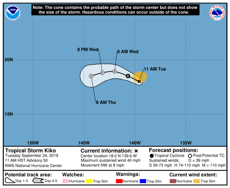
...KIKO HOPEFULLY ON THE WAY TO ITS FINAL DEMISE...

Tropical Storm Kiko Discussion Number 48
NWS National Hurricane Center Miami FL EP132019
1100 PM HST Mon Sep 23 2019

Satellite and microwave data indicate that the center of Kiko is
no longer in the middle of the central dense overcast. Instead,
increasing shear has caused the low-level center to be displaced to
the southwestern edge of the deep convection. Intensity estimates
are decreasing, and the initial wind speed is set to 45 kt, which
agrees best with recent 40-45 kt ASCAT data.

Kiko is moving northwestward at 9 kt. The storm is expected to turn
to the west-northwest on Tuesday in the flow between a mid-level
ridge to the northeast and a mid- to upper-level low to the west. By
Wednesday, Kiko is expected to turn back to the west and eventually
south-of-west as the shallower system is steered by the low-level
trade winds. The new track forecast is similar to the previous one,
except adjusted southward on days 2-3.

The storm should continue to weaken over the next few days due to
persistent south-southwest shear, marginal water temperatures, and
a dry mid-level environment. Guidance tonight has accelerated the
transition into a non-convective remnant low, with everything now
showing post-tropical status by 48 hours. The new forecast is
lower than the previous one, following the trend in the models, and
could be too slow in showing the storm's demise. Still, Kiko has
been one for the record books and should enter the top 10 in
longest-lived eastern Pacific tropical cyclones by midday Tuesday.


FORECAST POSITIONS AND MAX WINDS

INIT 24/0900Z 17.5N 138.2W 45 KT 50 MPH
12H 24/1800Z 18.5N 139.3W 35 KT 40 MPH
24H 25/0600Z 19.4N 140.8W 30 KT 35 MPH
36H 25/1800Z 19.7N 142.1W 25 KT 30 MPH
48H 26/0600Z 19.5N 143.1W 20 KT 25 MPH...POST-TROP/REMNT LOW
72H 27/0600Z 18.5N 145.5W 15 KT 15 MPH...POST-TROP/REMNT LOW
96H 28/0600Z...DISSIPATED

$$
Forecaster Blake
2 likes   


Return to “2019”

Who is online

Users browsing this forum: No registered users and 88 guests