ATL: JERRY - Models

Moderator: S2k Moderators

Message
Author
User avatar
Hypercane_Kyle
Category 5
Category 5
Posts: 2899
Joined: Sat Mar 07, 2015 7:58 pm
Location: Cape Canaveral, FL

Re: ATL: TEN - Models

#121 Postby Hypercane_Kyle » Tue Sep 17, 2019 6:46 pm

SconnieCane wrote:
plasticup wrote:12z HWRF with a wildly different solution: Category 5 in the Caribbean Sea south of Hispaniola

https://www.tropicaltidbits.com/analysis/models/hwrf/2019091712/hwrf_mslp_uv850_10L_43.png


Can always count on that model to bring the pain. Some of its Sim. IR products from a few days ago are uncanny looking at Humberto's presentation now, and it sniffed out Dorian and last year Michael ahead of everything else, but when you turn every storm into a monster hurricane I guess you're bound to be right once in awhile.


The HWRF nails it sometimes as far as intensity goes, see Michael and Dorian.

18z HWRF definitely coming in weaker though.
1 likes   
My posts are my own personal opinion, defer to the National Hurricane Center (NHC) and other NOAA products for decision making during hurricane season.

smithtim
Tropical Storm
Tropical Storm
Posts: 110
Joined: Thu Aug 28, 2008 1:43 pm

Re: ATL: TEN - Models

#122 Postby smithtim » Tue Sep 17, 2019 7:05 pm

LarryWx wrote:
sma10 wrote:
Aric Dunn wrote:Its interesting the majority like 75 percent of the EURO ensembles dont recurve during the first 5 days.. ( after that pointless to look at) . And are very tightly clustered.


https://i.ibb.co/3kDp4yW/94602061.gif


Also interesting that the Euro and UK both insist that while TD10 decides exactly what to do around the Bahamas, that another system tracks into the SouthEast Caribbean


That's a wave that is now west of C Verde and is in my mind the potentially more dangerous one for the western basin per model guidance tracks/timing.


On the assumption that TD 10 becomes Jerry that next one will be Karen... and while it is totally not a mathematical model that's my bosses boss name and prior to us hiring her a few years back east FLa hadn't see any storms really since 04-05 seasons. but ever since we've had almost yearly. So yeah be worried very worried if that next one spins up like some of the models are showing trailing behind. Far from technical mathematically modeling but Just sayin
5 likes   
Disclaimer: while I am PhD who does research I'm rambling here so this post should be taken only for entertainment...use nhc.noaa.gov for official forecasts!

FLoridian living round here for a while: 2016 Matthew & 1998 Earl lived barrier island landfall. Also lived nearby/inland for: 2017 Irma & 2004 Frances,Jeanne & 1992 Andrew

jlauderdal
S2K Supporter
S2K Supporter
Posts: 6771
Joined: Wed May 19, 2004 5:46 am
Location: NE Fort Lauderdale
Contact:

Re: RE: Re: ATL: TEN - Models

#123 Postby jlauderdal » Tue Sep 17, 2019 7:13 pm

Nimbus wrote:
AtlanticWind wrote:
gatorcane wrote:Big recurve on the 18Z GFS even with a weak storm. Humberto left too much of a weakness. Any CONUS threats watch the Western Caribbean or GOM.

Too early to say that for sure I think,
as we have some huge model swings this year.
Also 12z HWRF had it powerful storm using west.


18Z HWRF initializes with a much weaker storm further north through 57 hours.
Meanwhile the storm is intensifying this evening
4 likes   

Aric Dunn
Category 5
Category 5
Posts: 21228
Age: 41
Joined: Sun Sep 19, 2004 9:58 pm
Location: Ready for the Chase.
Contact:

Re: ATL: TEN - Models

#124 Postby Aric Dunn » Tue Sep 17, 2019 7:51 pm

yeah HWRF far weaker and of course then farther north.

however given the current environment and trends right now.. I would wager we have a much much stronger system sooner rather than later.
4 likes   
Note: If I make a post that is brief. Please refer back to previous posts for the analysis or reasoning. I do not re-write/qoute what my initial post said each time.
If there is nothing before... then just ask :)

Space & Atmospheric Physicist, Embry-Riddle Aeronautical University,
I believe the sky is falling...

User avatar
gatorcane
S2K Supporter
S2K Supporter
Posts: 23499
Age: 46
Joined: Sun Mar 13, 2005 3:54 pm
Location: Boca Raton, FL

Re: ATL: TEN - Models

#125 Postby gatorcane » Tue Sep 17, 2019 8:32 pm

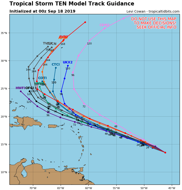
Big recurve here, looking fishy if it stays north of islands:

Image
2 likes   

User avatar
NDG
S2K Supporter
S2K Supporter
Posts: 14933
Joined: Sun Jul 09, 2006 10:14 pm
Location: Orlando, FL

Re: ATL: TEN - Models

#126 Postby NDG » Tue Sep 17, 2019 8:46 pm

Interesting how the 12z euro ensembles with the more westerly tracks in the majority are the strongest with the system as the earlier 12z HWRF did, so I guess a stronger system will mean a more westerly heading.
1 likes   

otowntiger
Category 5
Category 5
Posts: 1787
Joined: Tue Aug 31, 2004 7:06 pm
Location: Orlando

Re: ATL: TEN - Models

#127 Postby otowntiger » Tue Sep 17, 2019 9:15 pm

gatorcane wrote:Big recurve here, looking fishy if it stays north of islands:

https://i.postimg.cc/PxCsJKTp/10-L-tracks-00z.png

Agreed- very likely a recurve due to so many factors. Not the least of which is climatology.
4 likes   

floridasun78
Category 5
Category 5
Posts: 3755
Joined: Sun May 17, 2009 10:16 pm
Location: miami fl

Re: ATL: JERRY - Models

#128 Postby floridasun78 » Tue Sep 17, 2019 9:46 pm

look weakness will be west of high well east of coast and bahama and bermuda maybe only one need watch it
0 likes   

sma10
Category 5
Category 5
Posts: 1709
Joined: Tue Aug 02, 2005 1:13 pm

Re: ATL: TEN - Models

#129 Postby sma10 » Tue Sep 17, 2019 10:53 pm

If the 12z ICON has its way, by the end of the weekend we'll already be tracking Melissa!
1 likes   

LarryWx
Category 5
Category 5
Posts: 5699
Joined: Sun Sep 07, 2003 2:04 pm
Location: GA

Re: ATL: TEN - Models

#130 Postby LarryWx » Tue Sep 17, 2019 11:25 pm

0Z UKMET: a bit west of the last run but still way NE of the runs from 24 & 36 hours ago. This run ends as an approach to Bermuda:


TROPICAL STORM 10L ANALYSED POSITION : 14.0N 46.0W


ATCF IDENTIFIER : AL102019


VERIFYING TIME POSITION STRENGTH TENDENCY

-------------- -------- -------- --------

00UTC 18.09.2019 14.0N 46.0W WEAK

12UTC 18.09.2019 15.0N 48.3W WEAK LITTLE CHANGE

00UTC 19.09.2019 15.9N 50.8W WEAK LITTLE CHANGE

12UTC 19.09.2019 16.9N 53.9W WEAK LITTLE CHANGE

00UTC 20.09.2019 18.0N 56.9W WEAK LITTLE CHANGE

12UTC 20.09.2019 18.9N 60.0W WEAK LITTLE CHANGE

00UTC 21.09.2019 20.3N 62.6W WEAK LITTLE CHANGE

12UTC 21.09.2019 21.6N 64.9W WEAK LITTLE CHANGE

00UTC 22.09.2019 23.0N 66.4W WEAK INTENSIFYING SLIGHTLY

12UTC 22.09.2019 24.2N 67.5W MODERATE INTENSIFYING SLIGHTLY

00UTC 23.09.2019 25.3N 67.7W MODERATE INTENSIFYING SLIGHTLY

12UTC 23.09.2019 27.2N 67.2W STRONG INTENSIFYING SLIGHTLY

00UTC 24.09.2019 29.5N 67.7W STRONG LITTLE CHANGE
0 likes   
Personal Forecast Disclaimer:
The posts in this forum are NOT official forecasts and should not be used as such. They are just the opinion of the poster and may or may not be backed by sound meteorological data. They are NOT endorsed by any professional institution or storm2k.org. For official information, please refer to the NHC and NWS products.

User avatar
AtlanticWind
S2K Supporter
S2K Supporter
Posts: 1805
Age: 65
Joined: Sun Aug 08, 2004 9:57 pm
Location: Plantation,Fla

Re: ATL: TEN - Models

#131 Postby AtlanticWind » Tue Sep 17, 2019 11:41 pm

NDG wrote:Interesting how the 12z euro ensembles with the more westerly tracks in the majority are the strongest with the system as the earlier 12z HWRF did, so I guess a stronger system will mean a more westerly heading.


I noticed that too.

The GFS is hard to trust this year on the strength of systems,seems to be under developing everything.
Had a weak system with Humberto moving into florida.
0 likes   

User avatar
Hammy
Category 5
Category 5
Posts: 5594
Age: 40
Joined: Fri May 25, 2012 5:25 pm
Contact:

Re: ATL: TEN - Models

#132 Postby Hammy » Wed Sep 18, 2019 12:56 am

What effect if any will it have on the models that this was listed as a tropical storm at the time?
0 likes   
The above post is not official and should not be used as such. It is the opinion of the poster and may or may not be backed by sound meteorological data. It is not endorsed by any professional institution or storm2k.org. For official information, please refer to the NHC and NWS products.

LarryWx
Category 5
Category 5
Posts: 5699
Joined: Sun Sep 07, 2003 2:04 pm
Location: GA

Re: ATL: TEN - Models

#133 Postby LarryWx » Wed Sep 18, 2019 2:59 am

Although some 2/3 or so of the ~51 0Z Euro ens members still don't threaten the CONUS (most recurve hundreds of miles offshore though unfortunately many of these do threaten or even hit Bermuda), just over 25% do hit or are about to hit the CONUS. I count 6 in FL (5 pen., 1 pan.), ~3 in TX, one each in NC/SC/GA/LA, and one headed to ~AL. So, 13 hit and 1 is about to hit at the end of the run vs ~10 on the prior run.
1 likes   
Personal Forecast Disclaimer:
The posts in this forum are NOT official forecasts and should not be used as such. They are just the opinion of the poster and may or may not be backed by sound meteorological data. They are NOT endorsed by any professional institution or storm2k.org. For official information, please refer to the NHC and NWS products.

User avatar
northjaxpro
S2K Supporter
S2K Supporter
Posts: 8900
Joined: Mon Sep 27, 2010 11:21 am
Location: Jacksonville, FL

Re: ATL: TEN - Models

#134 Postby northjaxpro » Wed Sep 18, 2019 3:26 am

Jerry is looķng very impressive early this morning. The cyclone looks to have already built an impressive CDO and I am willing to bet it is quite a bit stronger than progged currently He is in an excellent environment of strengthening, .with virtually little vertical wind shear right now.

Looking at satellite presentation, I would think this is already nearing about 45- 50 knots currently. He is well organized and Jerry in my analysis will be a hurricane within the next 24 hours easily.

Jerry looks to become a very formidable and powerful tropical cyclone in the coming days, and I pray this system will recurve away from The Bahamas and hopefully safely away from Bermuda as well. It is going to be nervous monitoring this upcoming week . However, Jerry will get uncomfortably too close for comfort to The Bahamas and this re-curve solution is not a sure thing yet of course, and this as always will be predicated on timing with the trough/ridge placement late next week.
2 likes   
NEVER, EVER SAY NEVER in the tropics and weather in general, and most importantly, with life itself!!

________________________________________________________________________________________

Fay 2008 Beryl 2012 Debby 2012 Colin 2016 Hermine 2016 Julia 2016 Matthew 2016 Irma 2017 Dorian 2019

User avatar
chris_fit
Category 5
Category 5
Posts: 3078
Joined: Wed Sep 10, 2003 11:58 pm
Location: Tampa Bay Area, FL
Contact:

Re: ATL: TEN - Models

#135 Postby chris_fit » Wed Sep 18, 2019 4:13 am

LarryWx wrote:Although some 2/3 or so of the ~51 0Z Euro ens members still don't threaten the CONUS (most recurve hundreds of miles offshore though unfortunately many of these do threaten or even hit Bermuda), just over 25% do hit or are about to hit the CONUS. I count 6 in FL (5 pen., 1 pan.), ~3 in TX, one each in NC/SC/GA/LA, and one headed to ~AL. So, 13 hit and 1 is about to hit at the end of the run vs ~10 on the prior run.


Definitively 2 camps here....

Image


GFS Ens showing a first hint of a more W track too....

Image
0 likes   

User avatar
northjaxpro
S2K Supporter
S2K Supporter
Posts: 8900
Joined: Mon Sep 27, 2010 11:21 am
Location: Jacksonville, FL

Re: ATL: TEN - Models

#136 Postby northjaxpro » Wed Sep 18, 2019 4:25 am

GFS is indeed showing the west shift . Classic battle with the timing of the trough/ ridge placement.

This is going to be very interesting and extremely nerve wrecking with Jerry, especially with approach to The Bahamas later in the period. :(

As always, Timing with the tfough/ridge placement and forward speed of Jerry all are going to play critical factors!!!
Last edited by northjaxpro on Wed Sep 18, 2019 4:43 am, edited 1 time in total.
1 likes   
NEVER, EVER SAY NEVER in the tropics and weather in general, and most importantly, with life itself!!

________________________________________________________________________________________

Fay 2008 Beryl 2012 Debby 2012 Colin 2016 Hermine 2016 Julia 2016 Matthew 2016 Irma 2017 Dorian 2019

otowntiger
Category 5
Category 5
Posts: 1787
Joined: Tue Aug 31, 2004 7:06 pm
Location: Orlando

Re: ATL: TEN - Models

#137 Postby otowntiger » Wed Sep 18, 2019 4:42 am

chris_fit wrote:
LarryWx wrote:Although some 2/3 or so of the ~51 0Z Euro ens members still don't threaten the CONUS (most recurve hundreds of miles offshore though unfortunately many of these do threaten or even hit Bermuda), just over 25% do hit or are about to hit the CONUS. I count 6 in FL (5 pen., 1 pan.), ~3 in TX, one each in NC/SC/GA/LA, and one headed to ~AL. So, 13 hit and 1 is about to hit at the end of the run vs ~10 on the prior run.


Definitively 2 camps here....

https://i.imgur.com/KfNzXoY.png


GFS Ens showing a first hint of a more W track too....

https://i.imgur.com/gBmsz2U.png


still very solid majority with a definite and clear recurve. The pattern is well depicted and lots of signs point to this eventual outcome. Of course things can change but I’m not nervous about this one at this point.
Last edited by otowntiger on Wed Sep 18, 2019 5:32 am, edited 1 time in total.
0 likes   

User avatar
Blown Away
S2K Supporter
S2K Supporter
Posts: 9861
Joined: Wed May 26, 2004 6:17 am

Re: ATL: TEN - Models

#138 Postby Blown Away » Wed Sep 18, 2019 4:59 am

Euro ensembles reversed from Dorian, most of the real strong members go W and weaker members recurve. NHC is only keeping Jerry at 75mph through day 5, so they are not seeing intensification to a major like the W Euro ensembles show. Most likely outcome appears to be recurve safely OTS, maybe Bermuda.
1 likes   
Hurricane Eye Experience: David 79, Irene 99, Frances 04, Jeanne 04, Wilma 05...
Hurricane Brush Experience: Andrew 92, Erin 95, Floyd 99, Matthew 16, Irma 17, Ian 22, Nicole 22…

User avatar
Nimbus
Category 5
Category 5
Posts: 4928
Joined: Mon Jul 19, 2004 10:54 am

Re: ATL: JERRY - Models

#139 Postby Nimbus » Wed Sep 18, 2019 5:14 am

HWRF and GFS both showing a weaker system recurving for 00z.
Infra red presentation is quite symmetrical without any signs of dry air intrusion.
If the models get initialized with a stronger storm there may be a more westward trend in tracking but hopefully not into the Caribbean like yesterdays HWRF run.
0 likes   

User avatar
NDG
S2K Supporter
S2K Supporter
Posts: 14933
Joined: Sun Jul 09, 2006 10:14 pm
Location: Orlando, FL

Re: ATL: JERRY - Models

#140 Postby NDG » Wed Sep 18, 2019 5:39 am

Once again the Euro ensembles show that a stronger Jerry will have a more westerly course as it nears the Lesser Antilles into the Greater Antilles while a weaker Jerry before the Lesser Antilles will gain latitude.

Image
1 likes   


Return to “2019”

Who is online

Users browsing this forum: No registered users and 66 guests