ATL: BERTHA - Post-Tropical - Discussion
Moderator: S2k Moderators
-
Ivanhater

- Storm2k Moderator

- Posts: 10852
- Age: 37
- Joined: Fri Jul 01, 2005 8:25 am
- Location: Pensacola
Re: ATL: INVEST 91L - Discussion
Much needed rain falling across the northern gulf coast. This system is not producing much
1 likes
Michael
-
Aric Dunn
- Category 5

- Posts: 21228
- Age: 41
- Joined: Sun Sep 19, 2004 9:58 pm
- Location: Ready for the Chase.
- Contact:
Re: ATL: INVEST 91L - Discussion
This is almost certainly a TD at this point. and if recon was flying would probably find a TS>
the 120 mile bouy gusting to 36mph in the SE quad. I would wager recon would find plenty to Upgrade.
the 120 mile bouy gusting to 36mph in the SE quad. I would wager recon would find plenty to Upgrade.
4 likes
Note: If I make a post that is brief. Please refer back to previous posts for the analysis or reasoning. I do not re-write/qoute what my initial post said each time.
If there is nothing before... then just ask
Space & Atmospheric Physicist, Embry-Riddle Aeronautical University,
I believe the sky is falling...
If there is nothing before... then just ask
Space & Atmospheric Physicist, Embry-Riddle Aeronautical University,
I believe the sky is falling...

Re: ATL: INVEST 91L - Discussion
Nice convective burst ongoing near where the center relocation has been forecast. I can't really tell if the old low level circulation has been pulled over there or stretched out, but regardless the western edge of that burst looks like the place to watch right now.
0 likes
-
AJC3

- Admin

- Posts: 3868
- Age: 60
- Joined: Tue Aug 31, 2004 7:04 pm
- Location: West Melbourne, Florida
- Contact:
Re: ATL: INVEST 91L - Discussion
TheProfessor wrote:Some credit needs to be given to the GEPS, it sniffed out the tropical wave potentially developing into something well before any other model. Obviously it got location wrong, but that's not unusual 5-6 days out. Obviously it's not a depression yet, but it's definitely more than the very weak wave that wasn't even appearing on the other global models and their probabilistic forecasts.
Agreed. From what I saw over the holiday weekend, several of the global model and their respective ensemble runs were suggesting weak secondary low development on the Atlantic side near the FL and SE U.S. coast. In fact, the OP-UKMET started showing a consolidated low center forming over/east of the Florida peninsula on its runs from Saturday evening onward. Initial runs of the NAM showed stronger surface low development on the GOMEX side, same as the usually more reliable global guidance.
4 likes
-
cycloneye

- Admin
- Posts: 139025
- Age: 67
- Joined: Thu Oct 10, 2002 10:54 am
- Location: San Juan, Puerto Rico
Re: ATL: INVEST 91L - Discussion
Up to 30%
https://twitter.com/NHC_Atlantic/status/1265387485749604352
Special Tropical Weather Outlook
NWS National Hurricane Center Miami FL
450 PM EDT Tue May 26 2020
For the North Atlantic...Caribbean Sea and the Gulf of Mexico:
Special Tropical Weather Outlook issued to discuss the area of low
pressure near the northeast Florida coast.
1. An elongated area of low pressure located near the northeast Florida
coast and an associated upper-level disturbance are producing a
large area of showers and thunderstorms extending from portions of
Florida and coastal Georgia eastward for a few hundred miles over
the Atlantic waters. Some development of this system is possible
through early Wednesday if it remains offshore while moving slowly
northward near the northeastern Florida and Georgia coasts. The low
is expected to move well inland over the southeast U.S. by late
Wednesday, which should end any chance of tropical cyclone
formation.
Regardless of development, heavy rainfall could cause flash
flooding over portions of coastal sections of northeastern Florida
and Georgia through tonight, and over portions of the Carolinas on
Wednesday. Gusty winds could also produce rough marine conditions
and life-threatening surf and rip currents along the coasts of
northeastern Florida, Georgia, and the Carolinas through Wednesday.
For additional information, see products from your local National
Weather Service office. The next Special Tropical Weather Outlook
on this system will be issued by 3 AM EDT Wednesday, or earlier if
necessary.
* Formation chance through 48 hours...low...30 percent.
* Formation chance through 5 days...low...30 percent.
Forecaster Cangialosi
https://twitter.com/NHC_Atlantic/status/1265387485749604352
1 likes
Visit the Caribbean-Central America Weather Thread where you can find at first post web cams,radars
and observations from Caribbean basin members Click Here
and observations from Caribbean basin members Click Here
-
Hurricanehink

- S2K Supporter

- Posts: 2022
- Joined: Sun Nov 16, 2003 2:05 pm
- Location: New Jersey
Re: ATL: INVEST 91L - Discussion
Given the storms truck near a lot of buoys and weather stations, I suspect this could be one of those storms where advisories get issued on Bertha after reports of gale force winds
1 likes

Re: ATL: INVEST 91L - Discussion
Poor Miami-Dade, they are getting poured on once again by the system's tail end.
0 likes
-
TheAustinMan

- Category 4

- Posts: 995
- Age: 24
- Joined: Mon Jul 08, 2013 4:26 pm
- Location: United States
- Contact:
Re: ATL: INVEST 91L - Discussion
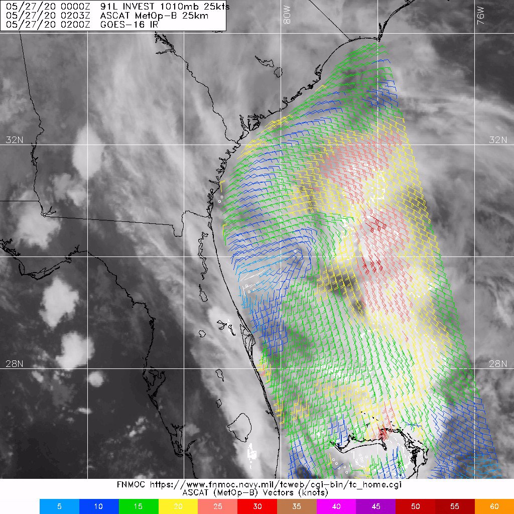
In lieu of recon, we'll likely know more about what's going on in the interior of Invest 91L tonight with a scatterometer pass from ASCAT onboard the METOP-B satellite. This morning's surface low has been getting elongated all day, and I'm curious to see how much of it remains. There may be other competing vortices in the convection that we don't know about as well. We'll probably have the scatterometer data about an hour before midnight Eastern.
Here's what I think the scatterometer swath will look like, which would give us a good glimpse of 91L's structure.
1.1MB. Source: Plotted in Google Earth, with satellite data from SSEC RealEarth. Data swath manually created based on my own guess. Not official.

Here's what I think the scatterometer swath will look like, which would give us a good glimpse of 91L's structure.
1.1MB. Source: Plotted in Google Earth, with satellite data from SSEC RealEarth. Data swath manually created based on my own guess. Not official.
4 likes


- Treat my opinions with a grain of salt. For official information see your local weather service.
-
northjaxpro

- S2K Supporter
- Posts: 8900
- Joined: Mon Sep 27, 2010 11:21 am
- Location: Jacksonville, FL
Re: ATL: INVEST 91L - Discussion
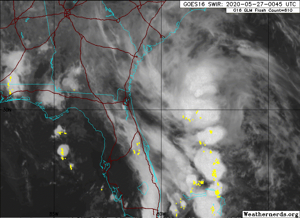
Picked up an additional 2/3 of an inch iof rain in another band of rain, which pivoted through the Jax metro area late this afternoon. Total rain from 91L at my home station just over 1.8 inches! What a blessing this rain was from Mother Nature!
3 likes
NEVER, EVER SAY NEVER in the tropics and weather in general, and most importantly, with life itself!!
________________________________________________________________________________________
Fay 2008 Beryl 2012 Debby 2012 Colin 2016 Hermine 2016 Julia 2016 Matthew 2016 Irma 2017 Dorian 2019
________________________________________________________________________________________
Fay 2008 Beryl 2012 Debby 2012 Colin 2016 Hermine 2016 Julia 2016 Matthew 2016 Irma 2017 Dorian 2019
Re: ATL: INVEST 91L - Discussion
Miami is getting pounded by rain from this right now, and the train is continuing. 6" so far at the airport.
1 likes

Re: ATL: INVEST 91L - Discussion
Aric Dunn wrote:This is almost certainly a TD at this point. and if recon was flying would probably find a TS>
the 120 mile bouy gusting to 36mph in the SE quad. I would wager recon would find plenty to Upgrade.
Winds and gusts from the south there Station 41010.
West Tampa buoy 42036 still has light winds from the south.
Winds from the north somewhere by Tomorrow?
0 likes
-
floridasun78
- Category 5
- Posts: 3755
- Joined: Sun May 17, 2009 10:16 pm
- Location: miami fl
Re: ATL: INVEST 91L - Discussion
dangerous flood here in miami for people driving i was caught into was dangerous drving water was going almost top part of tire we have report at miami airport 6.42 inch rain doing 2 hour
2 likes
-
cycloneye
- Admin
- Posts: 139025
- Age: 67
- Joined: Thu Oct 10, 2002 10:54 am
- Location: San Juan, Puerto Rico
Re: ATL: INVEST 91L - Discussion
0 likes
Visit the Caribbean-Central America Weather Thread where you can find at first post web cams,radars
and observations from Caribbean basin members Click Here
and observations from Caribbean basin members Click Here
-
northjaxpro
- S2K Supporter
- Posts: 8900
- Joined: Mon Sep 27, 2010 11:21 am
- Location: Jacksonville, FL
Re: ATL: INVEST 91L - Discussion
Yeah, earlier in the day I posted to my fellow Storm2K family in South Florida in the Florida Weather Thread to be on alert for strong to severe thunderstorms down that way as the tail end of the deep moisture from 91L impacts that region.
A very dire situation in Miami tonight with severe flash floodng. Nearly 7 inches at this hour reported. As I mentioned earlier, there will be a repeat tomorrow as well of potentially very heavy thunderstorms as that moisture tail will linger for the short to medium term period.
A very dire situation in Miami tonight with severe flash floodng. Nearly 7 inches at this hour reported. As I mentioned earlier, there will be a repeat tomorrow as well of potentially very heavy thunderstorms as that moisture tail will linger for the short to medium term period.
0 likes
NEVER, EVER SAY NEVER in the tropics and weather in general, and most importantly, with life itself!!
________________________________________________________________________________________
Fay 2008 Beryl 2012 Debby 2012 Colin 2016 Hermine 2016 Julia 2016 Matthew 2016 Irma 2017 Dorian 2019
________________________________________________________________________________________
Fay 2008 Beryl 2012 Debby 2012 Colin 2016 Hermine 2016 Julia 2016 Matthew 2016 Irma 2017 Dorian 2019
-
cycloneye
- Admin
- Posts: 139025
- Age: 67
- Joined: Thu Oct 10, 2002 10:54 am
- Location: San Juan, Puerto Rico
Re: ATL: INVEST 91L - Discussion
00z Best Track:

Location: 30.0°N 80.5°W
Maximum Winds: 25 kt Gusts: nan kt
Minimum Central Pressure: 1010 mb
Environmental Pressure: 1013 mb
Radius of Circulation: 120 NM
Radius of Maximum Wind: 60 NM
Maximum Winds: 25 kt Gusts: nan kt
Minimum Central Pressure: 1010 mb
Environmental Pressure: 1013 mb
Radius of Circulation: 120 NM
Radius of Maximum Wind: 60 NM
0 likes
Visit the Caribbean-Central America Weather Thread where you can find at first post web cams,radars
and observations from Caribbean basin members Click Here
and observations from Caribbean basin members Click Here

Re: ATL: INVEST 91L - Discussion
TheAustinMan wrote:In lieu of recon, we'll likely know more about what's going on in the interior of Invest 91L tonight with a scatterometer pass from ASCAT onboard the METOP-B satellite. This morning's surface low has been getting elongated all day, and I'm curious to see how much of it remains. There may be other competing vortices in the convection that we don't know about as well. We'll probably have the scatterometer data about an hour before midnight Eastern.
Here's what I think the scatterometer swath will look like, which would give us a good glimpse of 91L's structure.
1.1MB. Source: Plotted in Google Earth, with satellite data from SSEC RealEarth. Data swath manually created based on my own guess. Not official.
https://i.imgur.com/mthL4iE.png
What's the timing on this that we'd get?
0 likes
The above post is not official and should not be used as such. It is the opinion of the poster and may or may not be backed by sound meteorological data. It is not endorsed by any professional institution or storm2k.org. For official information, please refer to the NHC and NWS products.

Re: ATL: INVEST 91L - Discussion
Looks like the SpaceX first crewed mission will get scrubbed tomorrow. Even if the weather clears at the Cape, down range in the recovery area will be a no go. They will need fair weather in the unlikely event of an in flight abort diwn range as well as faith weather and seas for the booster recovery.
1 likes
-
TheAustinMan
- Category 4
- Posts: 995
- Age: 24
- Joined: Mon Jul 08, 2013 4:26 pm
- Location: United States
- Contact:
Re: ATL: INVEST 91L - Discussion
Hammy wrote:TheAustinMan wrote:In lieu of recon, we'll likely know more about what's going on in the interior of Invest 91L tonight with a scatterometer pass from ASCAT onboard the METOP-B satellite. This morning's surface low has been getting elongated all day, and I'm curious to see how much of it remains. There may be other competing vortices in the convection that we don't know about as well. We'll probably have the scatterometer data about an hour before midnight Eastern.
Here's what I think the scatterometer swath will look like, which would give us a good glimpse of 91L's structure.
1.1MB. Source: Plotted in Google Earth, with satellite data from SSEC RealEarth. Data swath manually created based on my own guess. Not official.
https://i.imgur.com/mthL4iE.png
What's the timing on this that we'd get?
We'll probably have the data by 4 UTC, though the ASCAT data will be from 2 UTC. No guarantees.
1 likes
- Treat my opinions with a grain of salt. For official information see your local weather service.
-
Nancy Smar

- Category 5
- Posts: 1081
- Age: 23
- Joined: Wed Aug 16, 2017 10:03 pm
Re: ATL: INVEST 91L - Discussion
Recent ASCAT data shows that the circulation remains elongated but near-gale force winds appear in the NE quadrant.
2 likes
-
Sciencerocks
- Category 5
- Posts: 7282
- Age: 38
- Joined: Thu Jul 06, 2017 1:51 am
Who is online
Users browsing this forum: No registered users and 27 guests