EPAC: ELIDA - Remnants
Moderator: S2k Moderators
-
Yellow Evan

- Professional-Met

- Posts: 15951
- Age: 25
- Joined: Fri Jul 15, 2011 12:48 pm
- Location: Henderson, Nevada/Honolulu, HI
- Contact:

Re: EPAC: ELIDA - Tropical Storm
Yellow Evan wrote:Expecting 50 or 55 then.
They went with 55 kt/998 mbar.
0 likes
Irene '11 Sandy '12 Hermine '16 5/15/2018 Derecho Fay '20 Isaias '20 Elsa '21 Henri '21 Ida '21
I am only a meteorology enthusiast who knows a decent amount about tropical cyclones. Look to the professional mets, the NHC, or your local weather office for the best information.
I am only a meteorology enthusiast who knows a decent amount about tropical cyclones. Look to the professional mets, the NHC, or your local weather office for the best information.
-
gatorcane

- S2K Supporter

- Posts: 23499
- Age: 46
- Joined: Sun Mar 13, 2005 3:54 pm
- Location: Boca Raton, FL
Re: EPAC: ELIDA - Tropical Storm
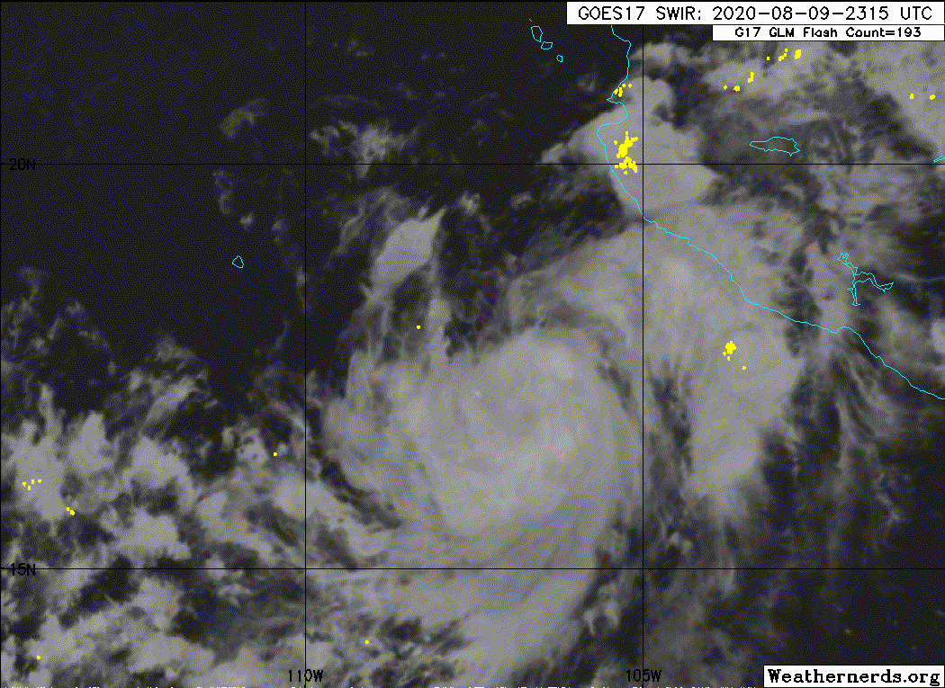
Deep convection with purple color firing around the CDO. Quickly intensifying.
https://www.tropicaltidbits.com/sat/sat ... product=ir
https://www.tropicaltidbits.com/sat/sat ... product=ir
3 likes
-
Yellow Evan
- Professional-Met
- Posts: 15951
- Age: 25
- Joined: Fri Jul 15, 2011 12:48 pm
- Location: Henderson, Nevada/Honolulu, HI
- Contact:
Re: EPAC: ELIDA - Tropical Storm
* GFS version *
* EAST PACIFIC 2020 SHIPS INTENSITY FORECAST *
* IR SAT DATA AVAILABLE, OHC AVAILABLE *
* ELIDA EP092020 08/10/20 00 UTC *
TIME (HR) 0 6 12 18 24 36 48 60 72 84 96 108 120 132 144 156 168
V (KT) NO LAND 55 60 65 71 76 81 81 73 65 55 45 33 26 19 17 17 17
V (KT) LAND 55 60 65 71 76 81 81 73 65 55 45 33 26 19 17 17 17
V (KT) LGEM 55 61 67 71 75 78 75 65 54 44 35 28 22 18 15 N/A N/A
Storm Type TROP TROP TROP TROP TROP TROP TROP TROP TROP TROP TROP TROP TROP TROP TROP N/A N/A
SHEAR (KT) 7 11 14 10 4 4 3 9 13 13 17 19 15 13 11 N/A N/A
SHEAR ADJ (KT) 0 0 -2 -5 -1 0 1 3 2 0 -1 -4 -1 1 0 N/A N/A
SHEAR DIR 308 315 321 310 297 267 199 183 196 206 195 214 217 233 288 N/A N/A
SST (C) 29.9 29.3 28.7 28.4 28.4 26.6 25.9 25.0 24.2 24.0 23.8 23.5 23.5 24.2 24.1 N/A N/A
POT. INT. (KT) 165 159 153 150 150 131 123 113 104 101 100 97 97 104 103 N/A N/A
200 MB T (C) -51.5 -51.6 -51.7 -51.3 -50.8 -51.3 -50.6 -51.1 -51.0 -51.3 -51.7 -52.3 -52.6 -52.7 -52.4 N/A N/A
200 MB VXT (C) 0.3 0.3 0.4 0.6 0.6 0.8 0.7 0.9 0.6 0.3 0.0 -0.4 -0.6 -0.2 -0.3 N/A N/A
TH_E DEV (C) 8 7 5 6 5 3 2 1 0 0 1 1 1 1 2 N/A N/A
700-500 MB RH 72 68 67 63 62 61 59 57 52 49 43 39 35 34 29 N/A N/A
MODEL VTX (KT) 15 15 17 19 20 22 21 19 18 14 11 7 6 4 3 LOST LOST
850 MB ENV VOR 27 24 18 23 39 11 3 -6 -8 14 28 21 29 22 16 N/A N/A
200 MB DIV 42 28 24 34 40 4 20 5 18 32 -1 2 -5 3 -29 N/A N/A
700-850 TADV 0 -3 -4 -10 -13 -6 6 8 13 6 7 4 3 2 0 N/A N/A
LAND (KM) 283 352 431 429 436 577 671 830 912 1018 1163 1327 1517 1701 1901 N/A N/A
LAT (DEG N) 17.5 18.1 18.7 19.1 19.5 20.1 20.9 21.5 22.0 22.2 22.0 21.7 21.3 xx.x xx.x N/A N/A
LONG(DEG W) 106.8 108.1 109.4 110.7 112.1 114.7 117.3 119.6 121.4 123.0 124.6 126.3 128.2 xxx.x xxx.x N/A N/A
STM SPEED (KT) 14 14 13 13 13 13 12 10 8 7 8 9 9 9 9 N/A N/A
HEAT CONTENT 26 15 12 10 9 1 0 0 0 0 0 0 0 0 0 N/A N/A
FORECAST TRACK FROM OFCI INITIAL HEADING/SPEED (DEG/KT):300/ 13 CX,CY: -10/ 7
T-12 MAX WIND: 40 PRESSURE OF STEERING LEVEL (MB): 624 (MEAN=587)
GOES IR BRIGHTNESS TEMP. STD DEV. 50-200 KM RAD: 15.8 (MEAN=14.5)
% GOES IR PIXELS WITH T < -20 C 50-200 KM RAD: 78.0 (MEAN=65.0)
PRELIM RI PROB (DV .GE. 35 KT IN 36 HR): 35.7
INDIVIDUAL CONTRIBUTIONS TO INTENSITY CHANGE
6 12 18 24 36 48 60 72 84 96 108 120 132 144 156 168
------------------------------------------------------------------------------
SAMPLE MEAN CHANGE 0. 0. 1. 1. 1. 2. 1. 1. 0. -0. -1. -2. -3. -4. -4. -5.
SST POTENTIAL 1. 2. 3. 4. 5. 5. 5. 4. 3. 2. -0. -3. -5. -8. -9. -11.
VERTICAL SHEAR MAG 0. 0. 0. 1. 3. 4. 5. 4. 3. 2. 0. -1. -1. -1. -2. -2.
VERTICAL SHEAR ADJ -0. 0. 1. 1. 1. 1. 0. 0. 0. 0. -0. -0. -0. -0. 0. 0.
VERTICAL SHEAR DIR -0. -0. -1. -1. -1. -2. -2. -2. -2. -2. -2. -2. -2. -1. -1. -1.
PERSISTENCE 3. 5. 5. 5. 4. 3. 2. 2. 1. 2. 1. 2. 2. 2. 2. 2.
200/250 MB TEMP. -0. -0. -1. -1. -1. -1. -0. 1. 1. 1. 1. -0. -2. -3. -4. -3.
THETA_E EXCESS 0. 0. 0. -0. -1. -2. -4. -5. -7. -8. -9. -10. -10. -11. -12. -13.
700-500 MB RH 0. 0. 0. 0. 0. 0. 0. -0. -0. -0. -1. -1. -1. -1. -2. -2.
MODEL VTX TENDENCY 0. 1. 3. 5. 6. 7. 5. 4. -1. -5. -10. -11. -12. -12. -11. -10.
850 MB ENV VORTICITY -0. -0. -0. -0. -0. 0. 0. 0. 0. 1. 1. 1. 1. 1. 0. 0.
200 MB DIVERGENCE -0. -0. -0. -0. -0. -1. -1. -1. -2. -2. -2. -2. -1. -1. -1. -0.
850-700 T ADVEC 0. 0. 0. 0. 0. 0. -0. -0. 0. 0. 0. 0. 1. 1. 1. 2.
ZONAL STORM MOTION 0. 0. 0. 1. 1. 1. 1. 1. 1. 1. 1. 1. 1. 1. 0. -0.
STEERING LEVEL PRES 0. 0. 0. 0. 1. 1. 1. 1. 1. 1. 1. 1. 1. 1. 0. 0.
DAYS FROM CLIM. PEAK 0. 0. 0. 0. 0. 0. 0. 1. 1. 2. 2. 2. 2. 3. 3. 3.
GOES PREDICTORS 0. -0. -0. -0. -0. 0. 0. 0. 0. 0. -0. -0. -0. 0. 0. 0.
OCEAN HEAT CONTENT -0. -0. -0. -0. -0. -1. -1. -1. -1. -0. -0. 0. 1. 2. 3. 4.
RI POTENTIAL 1. 2. 4. 6. 8. 8. 4. 1. -1. -2. -4. -4. -4. -4. -4. -4.
------------------------------------------------------------------------------
TOTAL CHANGE 5. 10. 16. 21. 26. 26. 18. 10. -0. -10. -22. -29. -36. -38. -38. -38.
CURRENT MAX WIND (KT): 55. LAT, LON: 17.5 106.8
** 2020 E. Pacific RI INDEX EP092020 ELIDA 08/10/20 00 UTC **
(SHIPS-RII PREDICTOR TABLE for 30 KT OR MOREMAXIMUM WIND INCREASE IN NEXT 24-h)
Predictor Value RI Predictor Range Scaled Value(0-1) % Contribution
POT = MPI-VMAX (KT) : 100.4 40.5 to 149.3 0.55 5.8
12 HR PERSISTENCE (KT) : 15.0 -22.0 to 44.0 0.56 7.0
850-200 MB SHEAR (KT) : 9.5 19.6 to 1.4 0.55 5.4
D200 (10**7s-1) : 33.6 -33.0 to 160.6 0.34 3.4
MAXIMUM WIND (KT) : 55.0 22.5 to 132.0 0.92 6.9
STD DEV OF IR BR TEMP : 15.8 37.8 to 2.1 0.62 3.8
HEAT CONTENT (KJ/CM2) : 14.4 2.7 to 106.7 0.11 0.7
BL DRY-AIR FLUX (W/M2) : 188.4 800.8 to -82.5 0.69 -5.4
%area of TPW <45 mm upshear : 0.0 56.6 to 0.0 1.00 2.6
2nd PC OF IR BR TEMP : 0.2 2.2 to -1.9 0.50 0.4
SHIPS Prob RI for 20kt/ 12hr RI threshold= 19% is 3.0 times climatological mean ( 6.3%)
SHIPS Prob RI for 25kt/ 24hr RI threshold= 33% is 2.6 times climatological mean (12.6%)
SHIPS Prob RI for 30kt/ 24hr RI threshold= 31% is 3.5 times climatological mean ( 8.6%)
SHIPS Prob RI for 35kt/ 24hr RI threshold= 22% is 3.5 times climatological mean ( 6.2%)
SHIPS Prob RI for 40kt/ 24hr RI threshold= 16% is 3.9 times climatological mean ( 4.2%)
SHIPS Prob RI for 45kt/ 36hr RI threshold= 25% is 3.8 times climatological mean ( 6.7%)
SHIPS Prob RI for 55kt/ 48hr RI threshold= 20% is 3.4 times climatological mean ( 5.9%)
SHIPS Prob RI for 65kt/ 72hr RI threshold= 0% is 0.0 times climatological mean ( 4.7%)
Matrix of RI probabilities
------------------------------------------------------------------------------
RI (kt / h) | 20/12 | 25/24 | 30/24 | 35/24 | 40/24 | 45/36 | 55/48 |65/72
------------------------------------------------------------------------------
SHIPS-RII: 18.7% 33.0% 30.5% 21.8% 16.4% 25.3% 20.2% 0.0%
Logistic: 5.8% 18.1% 8.7% 4.2% 3.0% 2.7% 0.6% 0.2%
Bayesian: 0.8% 2.7% 0.5% 0.1% 0.3% 0.2% 0.0% 0.0%
Consensus: 8.4% 17.9% 13.2% 8.7% 6.5% 9.4% 6.9% 0.1%
DTOPS: 16.0% 32.0% 19.0% 16.0% 13.0% 25.0% 7.0% 0.0%
## ANNULAR HURRICANE INDEX (AHI) EP092020 ELIDA 08/10/20 00 UTC ##
## STORM NOT ANNULAR, SCREENING STEP FAILED, NPASS=3 NFAIL=4 ##
## AHI= 0 (AHI OF 100 IS BEST FIT TO ANN. STRUC., 1 IS MARGINAL, 0 IS NOT ANNULAR) ##
0 likes
-
cycloneye

- Admin

- Posts: 139050
- Age: 67
- Joined: Thu Oct 10, 2002 10:54 am
- Location: San Juan, Puerto Rico
Re: EPAC: ELIDA - Tropical Storm
Tropical Storm Elida Discussion Number 5
NWS National Hurricane Center Miami FL EP092020
900 PM MDT Sun Aug 09 2020
Trends in satellite imagery over the past several hours indicate
that Elida continues to quickly increase in organization. There has
been an expanding central dense overcast, with the center of
circulation presumed to be underneath cloud tops of about -70 C.
Satellite intensity estimates TAFB and SAB as well as those from
UW-CIMSS support increasing the initial intensity to 55 kt.
Environmental conditions favor rapid intensification over the next
24 h or so. The latest SHIPS RI index indicates a better than 30
percent chance of Elida strengthening by 30 kt in the next 24 h,
and based on the convective trends, the official forecast closely
follows this guidance. By 48 h, the cyclone is forecast to cross the
26 C SST isotherm, and begin to enter a progressively drier and more
stable atmospheric environment. This should cause steady weakening
to occur. By 96 h, Elida is forecast to have been over waters cooler
than 25 C for nearly 36 h. And as a result, the simulated satellite
imagery by the GFS, ECMWF, and Canadian models all indicate that the
deep convection will dissipate by that time. Therefore, Elida is
expected to become a post-tropical cyclone by the 96 h forecast
period. The latest NHC intensity forecast is little changed from
from previous one, is close to the HCCA model intensity guidance for
the next couple of days, then trends towards the SHIPS guidance
thereafter.
Elida continues to move west-northwestward at 13 k, steered by a
mid-level ridge extending from northern Mexico to the east Pacific.
This pattern is forecast to remain in place for the next few days.
After that time, a slower westward or west-southwestward motion is
expected as the weakening cyclone is steered by the low-level trade
wind flow. The model track forecasts are in good agreement on this
scenario, and the latest NHC forecast track is in the middle of the
consensus track guidance.
FORECAST POSITIONS AND MAX WINDS
INIT 10/0300Z 17.8N 107.4W 55 KT 65 MPH
12H 10/1200Z 18.7N 109.4W 70 KT 80 MPH
24H 11/0000Z 19.6N 112.1W 80 KT 90 MPH
36H 11/1200Z 20.3N 114.8W 85 KT 100 MPH
48H 12/0000Z 21.0N 117.4W 80 KT 90 MPH
60H 12/1200Z 21.6N 119.6W 65 KT 75 MPH
72H 13/0000Z 22.1N 121.5W 55 KT 65 MPH
96H 14/0000Z 22.0N 124.9W 40 KT 45 MPH...POST-TROPICAL
120H 15/0000Z 21.1N 128.3W 30 KT 35 MPH...POST-TROP/REMNT LOW
$$
Forecaster Latto
0 likes
Visit the Caribbean-Central America Weather Thread where you can find at first post web cams,radars
and observations from Caribbean basin members Click Here
and observations from Caribbean basin members Click Here
-
Sciencerocks
- Category 5

- Posts: 7282
- Age: 38
- Joined: Thu Jul 06, 2017 1:51 am
-
1900hurricane

- Category 5
- Posts: 6044
- Age: 32
- Joined: Fri Feb 06, 2015 12:04 pm
- Location: Houston, TX
- Contact:
Re: EPAC: ELIDA - Tropical Storm
A bit east weighted, but the cyan ring is present.

0 likes
Contract Meteorologist. TAMU & MSST. Fiercely authentic, one of a kind. We are all given free will, so choose a life meant to be lived. We are the Masters of our own Stories.
Opinions expressed are mine alone.
Follow me on Twitter at @1900hurricane : Read blogs at https://1900hurricane.wordpress.com/
Opinions expressed are mine alone.
Follow me on Twitter at @1900hurricane : Read blogs at https://1900hurricane.wordpress.com/
-
Kingarabian

- S2K Supporter
- Posts: 15434
- Joined: Sat Aug 08, 2009 3:06 am
- Location: Honolulu, Hawaii
Re: EPAC: ELIDA - Tropical Storm
Interesting that the NHC cited global model IR imagery in their forecast.
0 likes
RIP Kobe Bryant
-
Yellow Evan
- Professional-Met
- Posts: 15951
- Age: 25
- Joined: Fri Jul 15, 2011 12:48 pm
- Location: Henderson, Nevada/Honolulu, HI
- Contact:
Re: EPAC: ELIDA - Tropical Storm
Elida is trying to form an eye I think. Probably won’t clear out first time but if it isn't already, this should be a hurricane fairly soon.
0 likes
-
Yellow Evan
- Professional-Met
- Posts: 15951
- Age: 25
- Joined: Fri Jul 15, 2011 12:48 pm
- Location: Henderson, Nevada/Honolulu, HI
- Contact:
-
Yellow Evan
- Professional-Met
- Posts: 15951
- Age: 25
- Joined: Fri Jul 15, 2011 12:48 pm
- Location: Henderson, Nevada/Honolulu, HI
- Contact:
Re: EPAC: ELIDA - Tropical Storm
* GFS version *
* EAST PACIFIC 2020 SHIPS INTENSITY FORECAST *
* IR SAT DATA AVAILABLE, OHC AVAILABLE *
* ELIDA EP092020 08/10/20 06 UTC *
TIME (HR) 0 6 12 18 24 36 48 60 72 84 96 108 120 132 144 156 168
V (KT) NO LAND 55 59 64 69 73 75 73 65 54 43 34 24 20 15 N/A N/A N/A
V (KT) LAND 55 59 64 69 73 75 73 65 54 43 34 24 20 15 N/A N/A N/A
V (KT) LGEM 55 59 63 67 69 69 65 56 46 37 29 23 19 16 N/A N/A N/A
Storm Type TROP TROP TROP TROP TROP TROP TROP TROP TROP TROP TROP TROP TROP TROP TROP N/A N/A
SHEAR (KT) 12 13 12 4 2 5 10 16 16 18 20 13 9 11 13 N/A N/A
SHEAR ADJ (KT) 0 -1 -5 -1 2 0 1 2 0 -1 -3 0 2 1 -1 N/A N/A
SHEAR DIR 324 323 327 336 257 226 197 215 209 195 198 215 243 319 314 N/A N/A
SST (C) 29.3 28.7 28.4 28.4 27.8 26.3 25.2 24.7 23.9 23.9 23.9 23.4 24.3 24.2 24.6 N/A N/A
POT. INT. (KT) 159 153 150 150 143 127 115 110 101 101 101 96 105 104 108 N/A N/A
200 MB T (C) -51.6 -51.6 -51.4 -50.8 -51.1 -51.1 -50.8 -51.3 -51.0 -51.7 -52.0 -52.7 -52.8 -52.9 -52.1 N/A N/A
200 MB VXT (C) 0.3 0.4 0.5 0.7 0.9 0.8 0.6 0.6 0.3 -0.1 -0.3 -0.7 -0.6 -0.1 0.0 N/A N/A
TH_E DEV (C) 6 5 6 5 4 3 1 0 0 0 1 1 2 1 2 N/A N/A
700-500 MB RH 69 68 64 63 62 59 57 53 48 44 38 33 33 31 33 N/A N/A
MODEL VTX (KT) 15 17 19 20 21 21 20 18 15 11 10 6 5 4 LOST LOST LOST
850 MB ENV VOR 26 22 29 38 31 5 2 -7 8 19 37 19 37 17 12 N/A N/A
200 MB DIV 26 26 36 37 37 16 16 15 14 23 13 -3 -8 -11 -19 N/A N/A
700-850 TADV -6 -5 -9 -11 -12 1 4 15 9 10 7 8 4 1 2 N/A N/A
LAND (KM) 358 443 430 443 500 623 758 882 971 1114 1281 1453 1644 1814 1991 N/A N/A
LAT (DEG N) 18.0 18.6 19.1 19.5 19.8 20.5 21.2 21.7 22.2 22.1 21.6 21.2 20.8 xx.x xx.x N/A N/A
LONG(DEG W) 108.1 109.5 110.8 112.2 113.5 116.2 118.6 120.6 122.4 124.1 125.7 127.4 129.3 xxx.x xxx.x N/A N/A
STM SPEED (KT) 13 14 14 13 13 12 11 9 8 8 8 9 9 8 8 N/A N/A
HEAT CONTENT 16 12 10 9 6 0 0 0 0 0 0 0 0 0 0 N/A N/A
FORECAST TRACK FROM OFCI INITIAL HEADING/SPEED (DEG/KT):300/ 12 CX,CY: -9/ 6
T-12 MAX WIND: 45 PRESSURE OF STEERING LEVEL (MB): 652 (MEAN=587)
GOES IR BRIGHTNESS TEMP. STD DEV. 50-200 KM RAD: 12.0 (MEAN=14.5)
% GOES IR PIXELS WITH T < -20 C 50-200 KM RAD: 76.0 (MEAN=65.0)
PRELIM RI PROB (DV .GE. 35 KT IN 36 HR): 29.3
INDIVIDUAL CONTRIBUTIONS TO INTENSITY CHANGE
6 12 18 24 36 48 60 72 84 96 108 120 132 144 156 168
------------------------------------------------------------------------------
SAMPLE MEAN CHANGE 0. 0. 1. 1. 1. 2. 1. 1. 0. -0. -1. -2. -3. -4. -4. -5.
SST POTENTIAL 1. 2. 3. 4. 5. 4. 4. 3. 1. -0. -2. -5. -7. -9. -11. -12.
VERTICAL SHEAR MAG -0. -0. 1. 1. 3. 4. 3. 2. 0. -2. -2. -2. -2. -2. -3. -3.
VERTICAL SHEAR ADJ 0. 0. 1. 1. 1. 1. 0. 0. 0. 0. -0. -0. -0. -0. 0. 0.
VERTICAL SHEAR DIR -0. -0. -1. -1. -1. -1. -1. -1. -1. -1. -1. -1. -1. -1. -1. -1.
PERSISTENCE 2. 3. 3. 3. 3. 2. 1. 1. 1. 1. 1. 1. 1. 1. 1. 1.
200/250 MB TEMP. -0. -0. -1. -1. -1. -1. -0. 0. 1. 0. -0. -2. -3. -4. -4. -4.
THETA_E EXCESS -0. -0. -0. -1. -2. -3. -5. -7. -8. -9. -10. -10. -11. -11. -12. -13.
700-500 MB RH 0. 0. 0. 0. 0. 0. -0. -0. -0. -1. -1. -1. -1. -2. -2. -3.
MODEL VTX TENDENCY 1. 2. 3. 4. 4. 4. 3. -1. -6. -8. -13. -13. -13. -12. -11. -10.
850 MB ENV VORTICITY -0. -0. 0. 0. -0. 0. 0. 0. 0. 0. 0. 0. 1. 1. 0. 0.
200 MB DIVERGENCE -0. -0. -0. -0. -0. -0. -1. -1. -2. -2. -2. -2. -2. -1. -1. -0.
850-700 T ADVEC 0. 0. 0. 0. 0. 0. -0. -0. 0. 0. 0. 0. 1. 1. 1. 1.
ZONAL STORM MOTION 0. 0. 0. 0. 1. 1. 1. 1. 1. 1. 1. 1. 1. 0. 0. -0.
STEERING LEVEL PRES 0. 0. 0. 1. 1. 1. 1. 1. 1. 2. 2. 2. 1. 1. 1. 0.
DAYS FROM CLIM. PEAK 0. 0. 0. 0. 0. 0. 0. 1. 1. 2. 2. 2. 2. 3. 3. 3.
GOES PREDICTORS 0. 0. 1. 1. 0. 0. -0. -0. -0. -1. -1. -1. -1. -1. -1. -1.
OCEAN HEAT CONTENT 0. -0. -0. -0. -0. -1. -1. -1. -1. -1. -0. 0. 1. 2. 3. 5.
RI POTENTIAL 1. 2. 3. 4. 6. 6. 3. 1. -1. -2. -2. -3. -3. -3. -3. -3.
------------------------------------------------------------------------------
TOTAL CHANGE 4. 9. 14. 18. 20. 18. 10. -1. -12. -21. -31. -35. -40. -42. -42. -43.
CURRENT MAX WIND (KT): 55. LAT, LON: 18.0 108.1
** 2020 E. Pacific RI INDEX EP092020 ELIDA 08/10/20 06 UTC **
(SHIPS-RII PREDICTOR TABLE for 30 KT OR MOREMAXIMUM WIND INCREASE IN NEXT 24-h)
Predictor Value RI Predictor Range Scaled Value(0-1) % Contribution
POT = MPI-VMAX (KT) : 96.0 40.5 to 149.3 0.51 5.3
12 HR PERSISTENCE (KT) : 10.0 -22.0 to 44.0 0.48 6.0
850-200 MB SHEAR (KT) : 8.6 19.6 to 1.4 0.60 5.8
D200 (10**7s-1) : 32.4 -33.0 to 160.6 0.34 3.4
MAXIMUM WIND (KT) : 55.0 22.5 to 132.0 0.92 6.8
STD DEV OF IR BR TEMP : 12.0 37.8 to 2.1 0.72 4.5
HEAT CONTENT (KJ/CM2) : 10.6 2.7 to 106.7 0.08 0.4
BL DRY-AIR FLUX (W/M2) : 212.4 800.8 to -82.5 0.67 -5.2
%area of TPW <45 mm upshear : 0.0 56.6 to 0.0 1.00 2.6
2nd PC OF IR BR TEMP : 0.4 2.2 to -1.9 0.44 0.3
SHIPS Prob RI for 20kt/ 12hr RI threshold= 16% is 2.6 times climatological mean ( 6.3%)
SHIPS Prob RI for 25kt/ 24hr RI threshold= 33% is 2.6 times climatological mean (12.6%)
SHIPS Prob RI for 30kt/ 24hr RI threshold= 30% is 3.5 times climatological mean ( 8.6%)
SHIPS Prob RI for 35kt/ 24hr RI threshold= 21% is 3.4 times climatological mean ( 6.2%)
SHIPS Prob RI for 40kt/ 24hr RI threshold= 16% is 3.8 times climatological mean ( 4.2%)
SHIPS Prob RI for 45kt/ 36hr RI threshold= 24% is 3.5 times climatological mean ( 6.7%)
SHIPS Prob RI for 55kt/ 48hr RI threshold= 18% is 3.1 times climatological mean ( 5.9%)
SHIPS Prob RI for 65kt/ 72hr RI threshold= 0% is 0.0 times climatological mean ( 4.7%)
Matrix of RI probabilities
------------------------------------------------------------------------------
RI (kt / h) | 20/12 | 25/24 | 30/24 | 35/24 | 40/24 | 45/36 | 55/48 |65/72
------------------------------------------------------------------------------
SHIPS-RII: 16.5% 32.8% 30.0% 21.1% 16.0% 23.8% 18.2% 0.0%
Logistic: 3.6% 15.4% 7.7% 3.4% 2.3% 1.4% 0.1% 0.1%
Bayesian: 0.1% 0.9% 0.2% 0.0% 0.1% 0.0% 0.0% 0.0%
Consensus: 6.7% 16.4% 12.6% 8.2% 6.1% 8.4% 6.1% 0.0%
DTOPS: 27.0% 41.0% 31.0% 23.0% 16.0% 12.0% 3.0% 0.0%
## ANNULAR HURRICANE INDEX (AHI) EP092020 ELIDA 08/10/20 06 UTC ##
## STORM NOT ANNULAR, SCREENING STEP FAILED, NPASS=3 NFAIL=4 ##
## AHI= 0 (AHI OF 100 IS BEST FIT TO ANN. STRUC., 1 IS MARGINAL, 0 IS NOT ANNULAR) ##
0 likes
-
Kingarabian
- S2K Supporter
- Posts: 15434
- Joined: Sat Aug 08, 2009 3:06 am
- Location: Honolulu, Hawaii
Re: EPAC: ELIDA - Tropical Storm
Most recent AMSU pass shows the center displaced west of the deep convection. This indicates weakening.

However the most recent IR imagery shows deep convection has build back west of the center.

However the most recent IR imagery shows deep convection has build back west of the center.
0 likes
RIP Kobe Bryant

Re: EPAC: ELIDA - Tropical Storm
Those AMSU passes are lower resolution so I don’t trust them as much. I don’t think the core really took that big of a hit. Convection has been maintaining with occasional bursts for hours now. I think this has probably reached hurricane status by now, with winds of 65-70kts, pressure 989-990mb.
0 likes
Solar Aquarian
Lunar Cancerian
 Sagittarian
Lunar Cancerian
-
Kingarabian
- S2K Supporter
- Posts: 15434
- Joined: Sat Aug 08, 2009 3:06 am
- Location: Honolulu, Hawaii
Re: EPAC: ELIDA - Tropical Storm
Chris90 wrote:Those AMSU passes are lower resolution so I don’t trust them as much. I don’t think the core really took that big of a hit. Convection has been maintaining with occasional bursts for hours now. I think this has probably reached hurricane status by now, with winds of 65-70kts, pressure 989-990mb.
They are low resolution but theyre still good for picking up on inner core convection. They still give you a good general idea on what's going on, especially at this stage. Advanced hurricanes, not so much. So compared to its previous passes that did show convection in the western quads, the presentation to me has clearly degraded within the time frame of that pass.
0 likes
RIP Kobe Bryant
-
Yellow Evan
- Professional-Met
- Posts: 15951
- Age: 25
- Joined: Fri Jul 15, 2011 12:48 pm
- Location: Henderson, Nevada/Honolulu, HI
- Contact:
Re: EPAC: ELIDA - Tropical Storm
It’s possible though I haven’t looked hard that dry air may have gotten in to the west side of the storm.
0 likes
-
Kingarabian
- S2K Supporter
- Posts: 15434
- Joined: Sat Aug 08, 2009 3:06 am
- Location: Honolulu, Hawaii
Re: EPAC: ELIDA - Tropical Storm
Tropical Storm Elida Discussion Number 6
NWS National Hurricane Center Miami FL EP092020
300 AM MDT Mon Aug 10 2020
After the earlier burst of deep convection and the development of a
small 10-nmi-wide low- to mid-level eye noted in passive microwave
satellite imagery, convection has waned somewhat and the eye feature
has eroded in the northwestern semicircle due to entrainment of dry
air, along with some modest northwesterly vertical wind shear. A
0314Z ASCAT-A overpass revealed peak winds of only 43 kt in the
northeastern quadrant, along with a radius of maximum winds (RMW)
of 10-15 nmi. Satellite intensity estimates range from T3.5/55 kt
from TAFB to T4.0/65 kt from SAB, along with a UW-CIMSS SATCON
estimate of 53 kt and an ADT estimate of 59 kt. An average of these
intensity estimates, and allowing for some undersampling by the
scatterometer instrument due to Elida's small RMW, supports
maintaining an intensity of 55 kt for this advisory.
The initial motion estimate remains west-northwestward or 300/13 kt.
Both the forecast track and rationale remain straight-forward and
basically unchanged from the previous advisory. Elida is expected to
be steered west-northwestward by a deep layer ridge to the north for
the next 72 hours or, followed by a westward motion on days 4 and 5
when Elida will be weakening over much cooler waters and becoming a
shallower cyclone. The latest NHC track guidance remains tightly
packed and, thus, the new official forecast is very similar to the
previous advisory track, and lies near the TVCE and NOAA-HCCA
consensus track models.
The brief intensity hiatus that Elida is experiencing is expected
to be short-lived due to the cyclone's small RMW and the vertical
shear forecast to decrease to less than 10 kt in the 12-36 hour
time frame. This should allow for Elida to strengthen -- possibly
even rapidly -- during the next 24 hours, followed by a leveling
off in the intensity due to the cyclone moving over sub-26C
sea-surface temperatures (SST). By 48-60 h, SSTs less than 25C and
modest southwesterly vertical wind shear will combine to induce
steady weakening. By 96 h or so, Elida is forecast to degenerate
into a post-tropical cyclone. The new official intensity forecast is
a little lower than the previous advisory, but is a little above
the consensus models IVCN and HCCA.
FORECAST POSITIONS AND MAX WINDS
INIT 10/0900Z 18.3N 108.8W 55 KT 65 MPH
12H 10/1800Z 19.1N 110.8W 65 KT 75 MPH
24H 11/0600Z 20.0N 113.5W 75 KT 85 MPH
36H 11/1800Z 20.8N 116.2W 80 KT 90 MPH
48H 12/0600Z 21.5N 118.6W 65 KT 75 MPH
60H 12/1800Z 22.2N 120.7W 55 KT 65 MPH
72H 13/0600Z 22.6N 122.6W 45 KT 50 MPH
96H 14/0600Z 22.2N 125.7W 35 KT 40 MPH...POST-TROPICAL
120H 15/0600Z 21.4N 128.8W 25 KT 30 MPH...POST-TROP/REMNT LOW
$$
Forecaster Stewart
0 likes
RIP Kobe Bryant
-
Yellow Evan
- Professional-Met
- Posts: 15951
- Age: 25
- Joined: Fri Jul 15, 2011 12:48 pm
- Location: Henderson, Nevada/Honolulu, HI
- Contact:
-
Yellow Evan
- Professional-Met
- Posts: 15951
- Age: 25
- Joined: Fri Jul 15, 2011 12:48 pm
- Location: Henderson, Nevada/Honolulu, HI
- Contact:
Re: EPAC: ELIDA - Tropical Storm
* GFS version *
* EAST PACIFIC 2020 SHIPS INTENSITY FORECAST *
* IR SAT DATA AVAILABLE, OHC AVAILABLE *
* ELIDA EP092020 08/10/20 12 UTC *
TIME (HR) 0 6 12 18 24 36 48 60 72 84 96 108 120 132 144 156 168
V (KT) NO LAND 60 65 69 75 77 78 73 64 53 42 33 26 20 17 N/A N/A N/A
V (KT) LAND 60 65 69 75 77 78 73 64 53 42 33 26 20 17 N/A N/A N/A
V (KT) LGEM 60 65 69 72 73 71 63 53 42 34 28 23 19 16 N/A N/A N/A
Storm Type TROP TROP TROP TROP TROP TROP TROP TROP TROP TROP TROP TROP TROP TROP TROP N/A N/A
SHEAR (KT) 12 11 6 3 4 7 13 13 12 16 10 10 8 8 7 N/A N/A
SHEAR ADJ (KT) 0 -4 -4 0 0 0 3 1 1 -1 2 0 4 6 3 N/A N/A
SHEAR DIR 324 324 336 319 261 194 204 207 205 198 223 216 239 282 260 N/A N/A
SST (C) 28.8 28.4 28.3 27.9 26.5 25.9 24.9 24.2 23.8 23.5 23.3 23.2 24.0 24.0 24.6 N/A N/A
POT. INT. (KT) 154 150 149 145 130 123 112 104 99 96 94 93 102 102 108 N/A N/A
200 MB T (C) -51.6 -51.4 -50.9 -51.1 -51.2 -50.5 -51.1 -50.8 -50.9 -51.2 -51.7 -52.0 -52.3 -52.0 -51.5 N/A N/A
200 MB VXT (C) 0.3 0.5 0.7 0.8 0.8 0.6 0.7 0.6 0.4 0.3 0.0 -0.4 -0.5 0.0 0.0 N/A N/A
TH_E DEV (C) 5 6 6 4 3 2 1 1 0 1 0 1 1 1 1 N/A N/A
700-500 MB RH 68 65 62 61 61 57 54 46 44 37 33 31 29 28 31 N/A N/A
MODEL VTX (KT) 17 19 19 22 21 21 20 17 13 11 7 5 3 LOST LOST LOST LOST
850 MB ENV VOR 20 28 33 27 15 14 -10 -16 9 30 29 27 12 -3 -26 N/A N/A
200 MB DIV 28 42 31 14 -7 24 11 7 4 -9 3 -19 0 -18 -21 N/A N/A
700-850 TADV -4 -6 -9 -9 -3 2 11 10 5 5 2 4 2 0 0 N/A N/A
LAND (KM) 408 425 411 458 539 633 785 865 999 1137 1282 1447 1621 1794 1969 N/A N/A
LAT (DEG N) 18.6 19.1 19.6 20.0 20.4 21.2 21.8 22.5 22.6 22.4 22.0 21.6 21.2 xx.x xx.x N/A N/A
LONG(DEG W) 109.1 110.5 111.8 113.2 114.5 117.1 119.3 121.3 123.1 124.6 126.0 127.6 129.3 xxx.x xxx.x N/A N/A
STM SPEED (KT) 13 14 13 13 13 12 10 9 7 7 7 8 8 8 8 N/A N/A
HEAT CONTENT 12 10 9 6 1 0 0 0 0 0 0 0 0 0 0 N/A N/A
FORECAST TRACK FROM OFCI INITIAL HEADING/SPEED (DEG/KT):300/ 12 CX,CY: -9/ 6
T-12 MAX WIND: 50 PRESSURE OF STEERING LEVEL (MB): 623 (MEAN=587)
GOES IR BRIGHTNESS TEMP. STD DEV. 50-200 KM RAD: 11.4 (MEAN=14.5)
% GOES IR PIXELS WITH T < -20 C 50-200 KM RAD: 96.0 (MEAN=65.0)
PRELIM RI PROB (DV .GE. 35 KT IN 36 HR): 28.5
INDIVIDUAL CONTRIBUTIONS TO INTENSITY CHANGE
6 12 18 24 36 48 60 72 84 96 108 120 132 144 156 168
------------------------------------------------------------------------------
SAMPLE MEAN CHANGE 0. 0. 1. 1. 1. 2. 1. 1. 0. -0. -1. -2. -3. -4. -4. -5.
SST POTENTIAL 1. 2. 3. 3. 3. 2. -0. -2. -4. -6. -9. -12. -15. -17. -19. -21.
VERTICAL SHEAR MAG -0. 0. 1. 2. 3. 3. 3. 3. 2. 1. 1. 1. 2. 2. 2. 2.
VERTICAL SHEAR ADJ 0. 1. 1. 1. 1. 1. 0. 0. 0. 0. -0. 0. 0. 0. -0. -0.
VERTICAL SHEAR DIR -0. -0. -0. -1. -1. -1. -1. -1. -1. -1. -1. -1. -1. -1. -1. -1.
PERSISTENCE 2. 3. 3. 3. 2. 2. 1. 1. 1. 1. 1. 1. 1. 1. 1. 1.
200/250 MB TEMP. -0. -0. -1. -1. -1. -1. 0. 1. 2. 2. 1. -1. -2. -4. -4. -3.
THETA_E EXCESS -0. -0. -0. -1. -2. -4. -6. -7. -9. -10. -10. -11. -11. -12. -13. -14.
700-500 MB RH 0. 0. 0. 0. -0. -0. -0. -1. -1. -1. -1. -2. -2. -2. -3. -4.
MODEL VTX TENDENCY 1. 1. 3. 3. 3. 3. -1. -5. -9. -14. -16. -18. -16. -15. -13. -12.
850 MB ENV VORTICITY -0. 0. 0. -0. -0. 0. 0. 0. 0. 1. 1. 1. 1. 1. 1. 0.
200 MB DIVERGENCE -0. -0. -0. -0. -1. -1. -1. -2. -3. -3. -3. -3. -2. -1. -1. -0.
850-700 T ADVEC 0. 0. 0. 0. 0. 0. 0. -0. 0. 0. 0. 0. 1. 1. 1. 1.
ZONAL STORM MOTION 0. 0. 0. 0. 1. 1. 1. 1. 1. 1. 1. 1. 1. 0. 0. -0.
STEERING LEVEL PRES 0. 0. 0. 0. 1. 1. 1. 1. 1. 1. 1. 1. 1. 1. 0. 0.
DAYS FROM CLIM. PEAK 0. 0. 0. 0. 0. 0. 0. 1. 1. 2. 2. 2. 2. 3. 3. 3.
GOES PREDICTORS 1. 1. 1. 1. 2. 2. 2. 2. 2. 2. 3. 3. 3. 2. 2. 2.
OCEAN HEAT CONTENT 0. -0. -0. -0. -0. -1. -1. -1. -1. -1. -0. 0. 1. 2. 3. 5.
RI POTENTIAL 1. 2. 3. 4. 6. 5. 3. 1. -0. -1. -2. -3. -3. -3. -2. -2.
------------------------------------------------------------------------------
TOTAL CHANGE 5. 9. 15. 17. 18. 13. 4. -7. -18. -27. -34. -40. -43. -45. -47. -47.
CURRENT MAX WIND (KT): 60. LAT, LON: 18.6 109.1
** 2020 E. Pacific RI INDEX EP092020 ELIDA 08/10/20 12 UTC **
(SHIPS-RII PREDICTOR TABLE for 30 KT OR MOREMAXIMUM WIND INCREASE IN NEXT 24-h)
Predictor Value RI Predictor Range Scaled Value(0-1) % Contribution
POT = MPI-VMAX (KT) : 85.3 40.5 to 149.3 0.41 4.3
12 HR PERSISTENCE (KT) : 10.0 -22.0 to 44.0 0.48 6.0
850-200 MB SHEAR (KT) : 7.2 19.6 to 1.4 0.68 6.5
D200 (10**7s-1) : 21.6 -33.0 to 160.6 0.28 2.8
MAXIMUM WIND (KT) : 60.0 22.5 to 132.0 0.97 7.2
STD DEV OF IR BR TEMP : 11.4 37.8 to 2.1 0.74 4.5
HEAT CONTENT (KJ/CM2) : 7.6 2.7 to 106.7 0.05 0.3
BL DRY-AIR FLUX (W/M2) : 252.4 800.8 to -82.5 0.62 -4.8
%area of TPW <45 mm upshear : 0.0 56.6 to 0.0 1.00 2.6
2nd PC OF IR BR TEMP : 0.3 2.2 to -1.9 0.46 0.3
SHIPS Prob RI for 20kt/ 12hr RI threshold= 19% is 3.0 times climatological mean ( 6.3%)
SHIPS Prob RI for 25kt/ 24hr RI threshold= 30% is 2.4 times climatological mean (12.6%)
SHIPS Prob RI for 30kt/ 24hr RI threshold= 30% is 3.5 times climatological mean ( 8.6%)
SHIPS Prob RI for 35kt/ 24hr RI threshold= 21% is 3.4 times climatological mean ( 6.2%)
SHIPS Prob RI for 40kt/ 24hr RI threshold= 16% is 3.9 times climatological mean ( 4.2%)
SHIPS Prob RI for 45kt/ 36hr RI threshold= 22% is 3.3 times climatological mean ( 6.7%)
SHIPS Prob RI for 55kt/ 48hr RI threshold= 0% is 0.0 times climatological mean ( 5.9%)
SHIPS Prob RI for 65kt/ 72hr RI threshold= 0% is 0.0 times climatological mean ( 4.7%)
Matrix of RI probabilities
------------------------------------------------------------------------------
RI (kt / h) | 20/12 | 25/24 | 30/24 | 35/24 | 40/24 | 45/36 | 55/48 |65/72
------------------------------------------------------------------------------
SHIPS-RII: 19.0% 30.4% 29.7% 21.2% 16.5% 22.1% 0.0% 0.0%
Logistic: 8.2% 18.2% 11.1% 4.2% 3.5% 1.4% 0.1% 0.0%
Bayesian: 0.8% 1.3% 0.1% 0.0% 0.0% 0.0% 0.0% 0.0%
Consensus: 9.3% 16.6% 13.6% 8.5% 6.7% 7.8% 0.0% 0.0%
DTOPS: 32.0% 31.0% 25.0% 21.0% 15.0% 7.0% 1.0% 0.0%
## ANNULAR HURRICANE INDEX (AHI) EP092020 ELIDA 08/10/20 12 UTC ##
## STORM NOT ANNULAR, SCREENING STEP FAILED, NPASS=4 NFAIL=3 ##
## AHI= 0 (AHI OF 100 IS BEST FIT TO ANN. STRUC., 1 IS MARGINAL, 0 IS NOT ANNULAR) ##
0 likes
Re: EPAC: ELIDA - Tropical Storm
A strong burst of convection is almost completely wrapped around the center, with hints of an eye showing. Elida might be close to rapidly intensifying now.
0 likes
Irene '11 Sandy '12 Hermine '16 5/15/2018 Derecho Fay '20 Isaias '20 Elsa '21 Henri '21 Ida '21
I am only a meteorology enthusiast who knows a decent amount about tropical cyclones. Look to the professional mets, the NHC, or your local weather office for the best information.
I am only a meteorology enthusiast who knows a decent amount about tropical cyclones. Look to the professional mets, the NHC, or your local weather office for the best information.
-
cycloneye
- Admin
- Posts: 139050
- Age: 67
- Joined: Thu Oct 10, 2002 10:54 am
- Location: San Juan, Puerto Rico
Re: EPAC: ELIDA - Tropical Storm
Tropical Storm Elida Discussion Number 7
NWS National Hurricane Center Miami FL EP092020
900 AM MDT Mon Aug 10 2020
Elida is very close to reaching hurricane strength. A 1218 UTC
SSMIS microwave pass revealed a nearly enclosed eyewall that was
somewhat eroded on the west side, possibly due to a bit of
north-northwesterly shear (as shown by the SHIPS diagnostics).
Subjective Dvorak estimates from TAFB and SAB are T3.5/55 kt, while
the objective guidance from UW-CIMSS is about 5-10 kt higher.
Because of the gradually improving structure in microwave imagery,
the initial intensity is set at 60 kt, which is a blend of the
intensity estimates.
Located along the southern periphery of a mid-level ridge which
extends from the south-central U.S. southwestward into the Pacific,
Elida is moving west-northwestward at 300/13 kt. Confidence in the
track forecast remains high since this ridge will be the main
driving force for the next 2-3 days, keeping Elida on a
west-northwestward but gradually slowing trajectory. In about 3
days, a weaker Elida will turn westward and slow down even further
due to lighter low-level steering winds. The spread in the guidance
does increase beyond 60 hours, particularly with the GFS showing a
significant poleward motion, but this unlikely scenario appears to
be due to the model tracker deviating from the path of the surface
circulation. The new NHC track forecast is nudged only slightly
north of the previous forecast, mainly due to a continuation of
Elida's recent trajectory. This new forecast is a blend of the
previous forecast and the NOAA-HCCA and TVDG consensus approaches.
The SHIPS model suggests that whatever shear is still affecting
Elida should die down within the next 12 hours, and the storm has
about 24 hours left over waters warmer than 26 degrees Celsius.
These conditions should allow for continued strengthening over the
next day or so, with rapid intensification still a possibility.
For that reason, the NHC intensity forecast is just above nearly
all of the guidance at 24 hours. After 24 hours, gradual weakening
should commence as Elida moves over cooler waters, and the rate of
weakening is likely to accelerate by day 3 once southwesterly shear
increases. Elida is expected to become a remnant low by day 4 and
dissipate by day 5, in accordance with the solutions shown by the
global models.
FORECAST POSITIONS AND MAX WINDS
INIT 10/1500Z 18.9N 109.8W 60 KT 70 MPH
12H 11/0000Z 19.7N 111.9W 70 KT 80 MPH
24H 11/1200Z 20.5N 114.5W 80 KT 90 MPH
36H 12/0000Z 21.3N 117.0W 75 KT 85 MPH
48H 12/1200Z 22.0N 119.3W 65 KT 75 MPH
60H 13/0000Z 22.5N 121.3W 50 KT 60 MPH
72H 13/1200Z 22.7N 122.8W 40 KT 45 MPH
96H 14/1200Z 22.5N 125.5W 25 KT 30 MPH...POST-TROP/REMNT LOW
120H 15/1200Z...DISSIPATED
$$
Forecaster Berg
0 likes
Visit the Caribbean-Central America Weather Thread where you can find at first post web cams,radars
and observations from Caribbean basin members Click Here
and observations from Caribbean basin members Click Here
Who is online
Users browsing this forum: No registered users and 19 guests