ATL: PAULETTE - Remnants - Discussion
Moderator: S2k Moderators
-
curtadams
- S2K Supporter

- Posts: 1118
- Joined: Sun Aug 28, 2005 7:57 pm
- Location: Orange, California
- Contact:
Re: ATL: PAULETTE - Post-Tropical - Discussion
GFS, CMC, and UKMET all agree this still has a deep warm core: http://moe.met.fsu.edu/cyclonephase/ (cyclone 1 on all three), just asymmetric, so this should be sub-tropical, not post-tropical.
3 likes
-
AJC3

- Admin

- Posts: 3869
- Age: 60
- Joined: Tue Aug 31, 2004 7:04 pm
- Location: West Melbourne, Florida
- Contact:
Re: ATL: PAULETTE - Post-Tropical - Discussion
curtadams wrote:GFS, CMC, and UKMET all agree this still has a deep warm core: http://moe.met.fsu.edu/cyclonephase/ (cyclone 1 on all three), just asymmetric, so this should be sub-tropical, not post-tropical.
It's extratropical. It has become a frontal cyclone, so there's no way it can be classified as an STC. Additionally, the convection is now primarily jet forced. The fact that it has a developing baroclinic leaf on it's northern side, (apparent on satellite) is a dead giveaway. I suspect the phase space diagrams are mistaking "warm core" for "warm sector". An argument could be made that's in a the final transient stage of XTC transition - i.e. a frontal hybrid with a remnant, strongly displaced warm "core" that is almost warm sector. However, the fact that it is well embedded in a baroclinic (frontal) zone, by definition, eliminates this from consideration as being classified as an STC.
5 likes
-
curtadams
- S2K Supporter
- Posts: 1118
- Joined: Sun Aug 28, 2005 7:57 pm
- Location: Orange, California
- Contact:
Re: ATL: PAULETTE - Post-Tropical - Discussion
NOAA's surface analysis shows Paulette separate from the front: 
High clouds to -60 near the center only is also very atypical for non-tropical systems.
High clouds to -60 near the center only is also very atypical for non-tropical systems.
0 likes
-
CrazyC83
- Professional-Met

- Posts: 33393
- Joined: Tue Mar 07, 2006 11:57 pm
- Location: Deep South, for the first time!
Re: ATL: PAULETTE - Post-Tropical - Discussion
I agree that Paulette is ET right now. However, it is only marginally so and these are the storms that can transition back to (sub)tropical easily. I'd have the probabilities of regenesis right now as 40/50.
0 likes
-
AJC3
- Admin
- Posts: 3869
- Age: 60
- Joined: Tue Aug 31, 2004 7:04 pm
- Location: West Melbourne, Florida
- Contact:
Re: ATL: PAULETTE - Post-Tropical - Discussion
curtadams wrote:NOAA's surface analysis shows Paulette separate from the front: https://i.imgur.com/BDxwYzZ.gif
High clouds to -60 near the center only is also very atypical for non-tropical systems.
This isn't the case for multiple reasons.
(1) Cold cloud tops associated with a baroclinic leaf in XTCs more often than not, easily reach those temperatures, being at jet stream level
(2) The 12Z Unified Surface Analysis, which was issued 3 hours before Paulette was declared a PTC, showed the fronts barely separated from the cyclone.

The 18Z USA clearly shows the cyclone is frontal.

(Also, the graphic you have attached to your post is from 2005)
On the the satellite image from 15Z (when Paulette was declared a PTC), you can clearly see that the structure of the cyclone on satellite is not that of a STC. Both the the developing baroclinic leaf on its north flank, and the warm and cold fronts to it south and east are apparent. Additionally, widespread cold air stratocumulus is being drawn into the system. Clearly the deep layer environment is baroclinic, not barotropic. This is about as textbook as you can get for a post-tropical cyclone that has recently completed XT transition...

11 likes

Re: ATL: PAULETTE - Post-Tropical - Discussion
0 likes
The above post is not official and should not be used as such. It is the opinion of the poster and may or may not be backed by sound meteorological data. It is not endorsed by any professional institution or storm2k.org. For official information, please refer to the NHC and NWS products.

Re: ATL: PAULETTE - Post-Tropical - Discussion
Hammy wrote::uarrow: What affect is all that smoke going to have on intensity and possibly inhibiting redevelopment?
One of many questions that have to be figured out with this awkward season.
0 likes
Personal Forecast Disclaimer:
The posts in this forum are NOT official forecast and should not be used as such. They are just the opinion of the poster and may or may not be backed by sound meteorological data. They are NOT endorsed by any professional institution or storm2k.org. For official information, please refer to the NHC and NWS products.
The posts in this forum are NOT official forecast and should not be used as such. They are just the opinion of the poster and may or may not be backed by sound meteorological data. They are NOT endorsed by any professional institution or storm2k.org. For official information, please refer to the NHC and NWS products.
-
Kazmit

- Category 5

- Posts: 1915
- Age: 21
- Joined: Mon Jul 25, 2016 8:49 am
- Location: Williamsburg VA for college, Bermuda otherwise
Re: ATL: PAULETTE - Post-Tropical - Discussion
Most symmetrical storm of the season?
0 likes
Igor 2010, Sandy 2012, Fay 2014, Gonzalo 2014, Joaquin 2015, Nicole 2016, Humberto 2019
I am only a tropical weather enthusiast. My predictions are not official and may or may not be backed by sound meteorological data. For official information, please refer to the NHC and NWS products.
I am only a tropical weather enthusiast. My predictions are not official and may or may not be backed by sound meteorological data. For official information, please refer to the NHC and NWS products.
Re: ATL: PAULETTE - Post-Tropical - Discussion
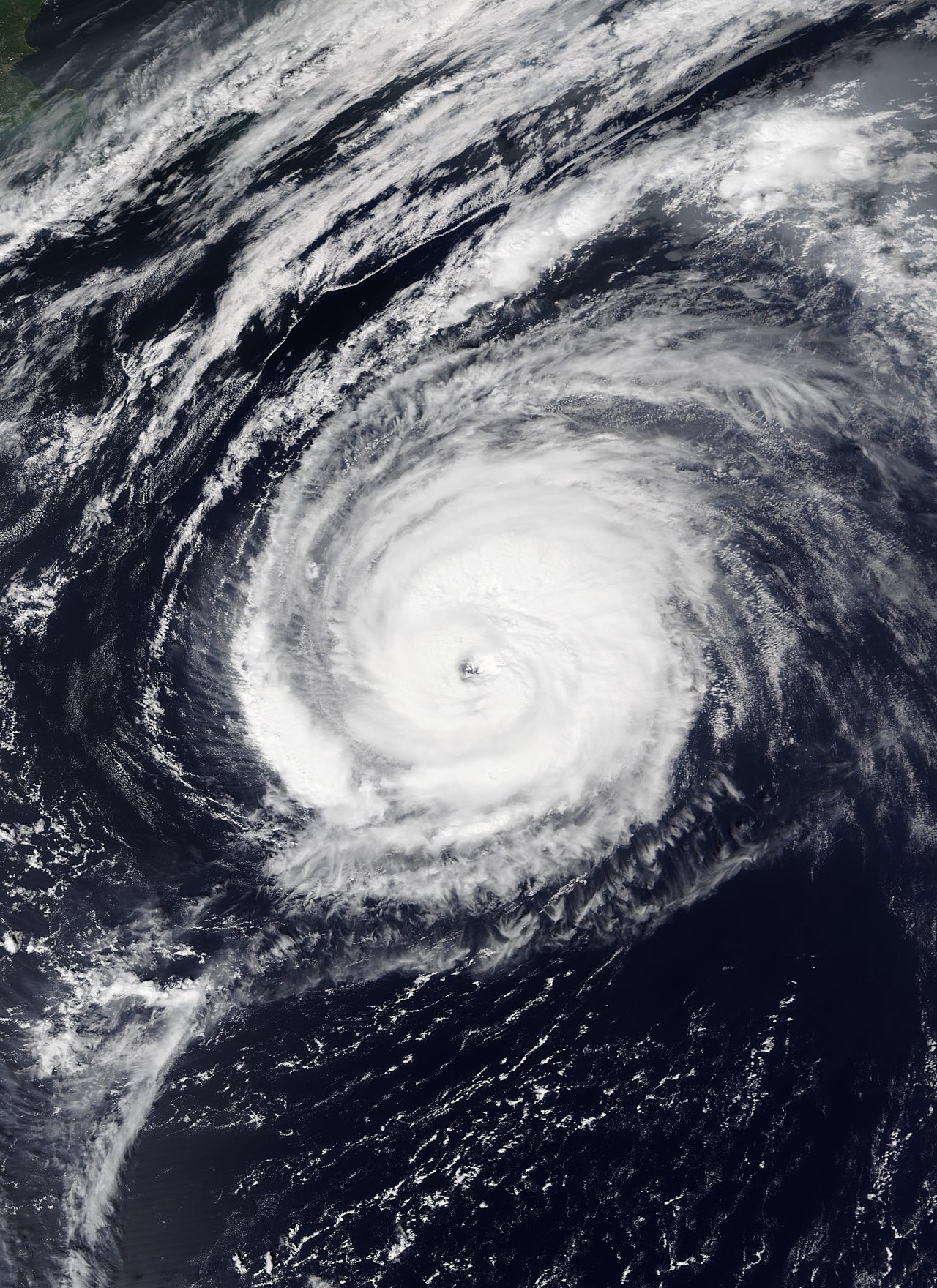
Kazmit wrote:Most symmetrical storm of the season?
https://upload.wikimedia.org/wikipedia/commons/thumb/4/49/Paulette_2020-09-14_Suomi_NPP.jpg/1280px-Paulette_2020-09-14_Suomi_NPP.jpg
So how big can she get? And if that is a current picture, how is she Post-tropical, she still looks tropical to me.
0 likes
Personal Forecast Disclaimer:
The posts in this forum are NOT official forecast and should not be used as such. They are just the opinion of the poster and may or may not be backed by sound meteorological data. They are NOT endorsed by any professional institution or storm2k.org. For official information, please refer to the NHC and NWS products.
The posts in this forum are NOT official forecast and should not be used as such. They are just the opinion of the poster and may or may not be backed by sound meteorological data. They are NOT endorsed by any professional institution or storm2k.org. For official information, please refer to the NHC and NWS products.
-
Kazmit
- Category 5
- Posts: 1915
- Age: 21
- Joined: Mon Jul 25, 2016 8:49 am
- Location: Williamsburg VA for college, Bermuda otherwise
Re: ATL: PAULETTE - Post-Tropical - Discussion
Blinhart wrote:Kazmit wrote:Most symmetrical storm of the season?
https://upload.wikimedia.org/wikipedia/commons/thumb/4/49/Paulette_2020-09-14_Suomi_NPP.jpg/1280px-Paulette_2020-09-14_Suomi_NPP.jpg
So how big can she get? And if that is a current picture, how is she Post-tropical, she still looks tropical to me.
That was from a couple days ago.
0 likes
Igor 2010, Sandy 2012, Fay 2014, Gonzalo 2014, Joaquin 2015, Nicole 2016, Humberto 2019
I am only a tropical weather enthusiast. My predictions are not official and may or may not be backed by sound meteorological data. For official information, please refer to the NHC and NWS products.
I am only a tropical weather enthusiast. My predictions are not official and may or may not be backed by sound meteorological data. For official information, please refer to the NHC and NWS products.
-
CrazyC83
- Professional-Met
- Posts: 33393
- Joined: Tue Mar 07, 2006 11:57 pm
- Location: Deep South, for the first time!
Re: ATL: PAULETTE - Post-Tropical - Discussion
The posts in this forum are NOT official forecasts and should not be used as such. They are just the opinion of the poster and may or may not be backed by sound meteorological data. They are NOT endorsed by any professional institution or STORM2K. For official information, please refer to products from the NHC and NWS.
My BT analysis for Paulette:
AL172020, PAULETTE, 47,
20200906, 0000, , LO, 18.2N, 35.3W, 30, 1008,
20200906, 0600, , LO, 18.0N, 37.6W, 30, 1007,
20200906, 1200, , LO, 17.3N, 39.5W, 30, 1006,
20200906, 1800, , LO, 16.9N, 40.5W, 30, 1006,
20200907, 0000, , TD, 16.9N, 41.4W, 30, 1005,
20200907, 0600, , TD, 17.0N, 41.9W, 30, 1005,
20200907, 1200, , TS, 17.1N, 42.2W, 35, 1004,
20200907, 1800, , TS, 17.3N, 42.4W, 40, 1002,
20200908, 0000, , TS, 17.6N, 42.6W, 40, 1001,
20200908, 0600, , TS, 17.9N, 42.8W, 45, 999,
20200908, 1200, , TS, 18.2N, 43.1W, 50, 996,
20200908, 1800, , TS, 18.5N, 43.7W, 55, 993,
20200909, 0000, , TS, 18.8N, 44.4W, 55, 992,
20200909, 0600, , TS, 19.1N, 45.2W, 55, 992,
20200909, 1200, , TS, 19.5N, 46.0W, 55, 991,
20200909, 1800, , TS, 19.9N, 46.8W, 55, 991,
20200910, 0000, , TS, 20.4N, 47.6W, 50, 994,
20200910, 0600, , TS, 20.8N, 48.3W, 50, 994,
20200910, 1200, , TS, 21.3N, 48.9W, 50, 993,
20200910, 1800, , TS, 21.9N, 49.6W, 55, 989,
20200911, 0000, , TS, 22.4N, 50.4W, 60, 986,
20200911, 0600, , TS, 22.9N, 51.2W, 55, 988,
20200911, 1200, , TS, 23.5N, 52.1W, 55, 988,
20200911, 1800, , TS, 24.2N, 53.2W, 55, 987,
20200912, 0000, , TS, 25.4N, 54.3W, 55, 987,
20200912, 0600, , TS, 26.5N, 55.6W, 60, 983,
20200912, 1200, , TS, 27.3N, 56.7W, 60, 982,
20200912, 1800, , TS, 28.1N, 57.9W, 60, 982,
20200913, 0000, , TS, 28.5N, 59.1W, 60, 981,
20200913, 0600, , TS, 29.1N, 60.2W, 60, 979,
20200913, 1200, , HU, 29.6N, 61.4W, 65, 976,
20200913, 1800, , HU, 30.2N, 62.6W, 65, 976,
20200914, 0000, , HU, 30.9N, 63.6W, 70, 973,
20200914, 0600, , HU, 31.8N, 64.4W, 75, 972,
20200914, 0900, L, HU, 32.3N, 64.7W, 75, 970,
20200914, 1200, , HU, 32.9N, 64.9W, 80, 967,
20200914, 1800, , HU, 33.9N, 64.4W, 90, 957,
20200914, 2100, I, HU, 34.5N, 63.9W, 95, 952,
20200915, 0000, , HU, 35.1N, 63.3W, 90, 955,
20200915, 0600, , HU, 36.3N, 62.0W, 90, 955,
20200915, 1200, , HU, 37.6N, 59.3W, 90, 955,
20200915, 1800, , HU, 38.8N, 56.5W, 85, 957,
20200916, 0000, , HU, 40.0N, 54.0W, 85, 957,
20200916, 0600, , HU, 41.2N, 50.8W, 85, 958,
20200916, 1200, , EX, 42.6N, 46.9W, 80, 960,
20200916, 1800, , EX, 44.9N, 43.6W, 70, 968,
20200917, 0000, , EX, 45.1N, 41.0W, 60, 975,
Overall changes are minor. However, the big changes are that the intensity is lowered slightly before Bermuda (75 kt at landfall there) and increased slightly afterward. I estimate that Paulette peaked at 2100Z September 14 (non-synoptic time) when it was closest to T5.5 and some were assigning that. At that time, my estimate is 95 kt. The pressures are also lowered based on trends from when Recon was in the storm (minimum pressure becomes 952 mb).
1 likes
-
AnnularCane

- S2K Supporter
- Posts: 2634
- Joined: Thu Jun 08, 2006 9:18 am
- Location: Wytheville, VA
Re: ATL: PAULETTE - Post-Tropical - Discussion
Is Paulette still out there? Thought they'd at least have a colored circle or something.
0 likes
-
tolakram
- Admin
- Posts: 19165
- Age: 60
- Joined: Sun Aug 27, 2006 8:23 pm
- Location: Florence, KY (name is Mark)
Re: ATL: PAULETTE - Post-Tropical - Discussion
AnnularCane wrote:Is Paulette still out there? Thought they'd at least have a colored circle or something.
Top near the center. Giant low now.

5 likes
M a r k
- - - - -
Join us in chat: Storm2K Chatroom Invite. Android and IOS apps also available.
The posts in this forum are NOT official forecasts and should not be used as such. Posts are NOT endorsed by any professional institution or STORM2K.org. For official information and forecasts, please refer to NHC and NWS products.

Re: ATL: PAULETTE - Post-Tropical - Discussion
Post-TC Paulette is now on the TWO at 10/20 odds for right now.
She’s forecasted to move straight south in warmer waters and stall there so she should have a decent shot at becoming tropical again.

She’s forecasted to move straight south in warmer waters and stall there so she should have a decent shot at becoming tropical again.
Tropical Weather Outlook
NWS National Hurricane Center Miami FL
200 AM EDT Fri Sep 18 2020
For the North Atlantic...Caribbean Sea and the Gulf of Mexico:
3. Post-tropical cyclone Paulette is located several hundred miles
north-northwest of the Azores. The cyclone is forecast to move
quickly southward for the next several days and then stall over
marginally warm waters a few hundred miles south or south-southwest
of the Azores by the end of the weekend. The cyclone could
subsequently redevelop tropical characteristics late this weekend or
early next week while it moves little.
* Formation chance through 48 hours...low...10 percent.
* Formation chance through 5 days...low...20 percent.
3 likes
-
ouragans

- Category 1

- Posts: 465
- Age: 52
- Joined: Sun Jun 12, 2011 12:09 pm
- Location: Abymes, Guadeloupe F.W.I
- Contact:
Re: ATL: PAULETTE - Post-Tropical - Discussion

3. Post-tropical cyclone Paulette is located several hundred miles north-northwest of the Azores. The cyclone is forecast to move quickly southward for the next few days and then stall over marginally warm waters a few hundred miles south or south-southwest
of the Azores by the end of the weekend. The cyclone could subsequently redevelop tropical characteristics late this weekend or early next week while it moves little.
* Formation chance through 48 hours...low...20 percent.
* Formation chance through 5 days...low...30 percent.
0 likes
Personal forecast disclaimer
This post is a personal point of view, not an information. Please refer to official statements for life-threatening decisions.
David '79, Frederic '79, Hugo '89, Iris, Luis & Marilyn '95, Georges '98, Lenny '99, Dean '07, Irma '17, Maria '17, Fiona '22, Philippe '23, Tammy '23
16°13'33.3,"6N -61°36'39.5"W
-
EquusStorm

- Category 5
- Posts: 1649
- Age: 33
- Joined: Thu Nov 07, 2013 1:04 pm
- Location: Jasper, AL
- Contact:
Re: ATL: PAULETTE - Post-Tropical - Discussion
An area of interest diving south from 43N 30W is just peak 2020
1 likes
Colors of lost purpose on the canvas of irrelevance
Not a meteorologist, in fact more of an idiot than anything. You should probably check with the NHC or a local NWS office for official information.
Not a meteorologist, in fact more of an idiot than anything. You should probably check with the NHC or a local NWS office for official information.

Re: ATL: PAULETTE - Post-Tropical - Discussion
We just may end up seeing Paulette active at the same time as Alpha after all.
2 likes
-
AnnularCane
- S2K Supporter
- Posts: 2634
- Joined: Thu Jun 08, 2006 9:18 am
- Location: Wytheville, VA
Re: ATL: PAULETTE - Post-Tropical - Discussion
I keep imagining Paulette waking from her slumber and noticing that the Atlantic is just different now. Like where did Sally go? And who are these new guys? 
5 likes
-
gfsperpendicular

- Category 1
- Posts: 383
- Age: 19
- Joined: Mon Jun 19, 2017 3:04 pm
- Location: Northern Virginia
Re: ATL: PAULETTE - Post-Tropical - Discussion
AnnularCane wrote:I keep imagining Paulette waking from her slumber and noticing that the Atlantic is just different now. Like where did Sally go? And who are these new guys?
And why does the new girl in the gulf have such a weird name?
4 likes
I'm not sleeping, I'm waiting for the 0900 UTC advisory!
#1 CMC stan
#1 CMC stan
Re: ATL: PAULETTE - Post-Tropical - Discussion
gfsperpendicular wrote:AnnularCane wrote:I keep imagining Paulette waking from her slumber and noticing that the Atlantic is just different now. Like where did Sally go? And who are these new guys?
And why does the new girl in the gulf have such a weird name?
Absolutely floored we could have Beta (or heck maybe even Gamma!) by the time Paulette could reform. That’s a 6-7 name gap!!! Easily demonstrates the most active September on record...ever.
1 likes
Who is online
Users browsing this forum: No registered users and 32 guests