ATL: SAM - Remnants - Discussion

Moderator: S2k Moderators

Message
Author
User avatar
cheezyWXguy
Category 5
Category 5
Posts: 5529
Joined: Mon Feb 13, 2006 12:29 am
Location: Dallas, TX

Re: ATL: SAM - Hurricane - Discussion

#1521 Postby cheezyWXguy » Mon Sep 27, 2021 3:39 pm

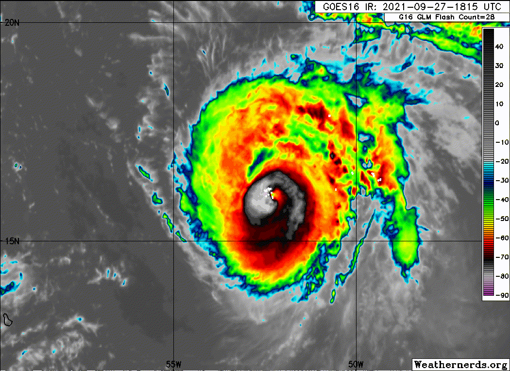
grapealcoholic wrote:It's already rapidly strengthened today, and now it's taking on a shrimp look. Wouldn't count out more RI

It hasn’t though, we’re looking at a 5-10mb drop and 5-10kt increase since this morning. It’s improving, but don’t expect anything rapid until it finishes sorting out its multiple eyewalls
5 likes   

User avatar
kevin
Category 5
Category 5
Posts: 1768
Age: 25
Joined: Wed Aug 28, 2019 4:35 am

Re: ATL: SAM - Hurricane - Discussion

#1522 Postby kevin » Mon Sep 27, 2021 3:39 pm

But seriously Sam is looking really good right now. It looks like we might finally have a recon now that will arrive at good moment for us online storm trackers. No RI yet, but probably steady continuous strengthening.
0 likes   

grapealcoholic
Category 2
Category 2
Posts: 634
Joined: Tue Aug 10, 2021 3:26 pm

Re: ATL: SAM - Hurricane - Discussion

#1523 Postby grapealcoholic » Mon Sep 27, 2021 4:04 pm

The outer band in the SE quad will slow things down
0 likes   

tolakram
Admin
Admin
Posts: 19165
Age: 60
Joined: Sun Aug 27, 2006 8:23 pm
Location: Florence, KY (name is Mark)

Re: ATL: SAM - Hurricane - Discussion

#1524 Postby tolakram » Mon Sep 27, 2021 4:07 pm

3 likes   
M a r k
- - - - -
Join us in chat: Storm2K Chatroom Invite. Android and IOS apps also available.

The posts in this forum are NOT official forecasts and should not be used as such. Posts are NOT endorsed by any professional institution or STORM2K.org. For official information and forecasts, please refer to NHC and NWS products.

User avatar
skyline385
Category 5
Category 5
Posts: 2444
Age: 33
Joined: Wed Aug 26, 2020 11:15 pm
Location: Palm Beach County FL

Re: ATL: SAM - Hurricane - Discussion

#1525 Postby skyline385 » Mon Sep 27, 2021 4:21 pm

kevin wrote:But seriously Sam is looking really good right now. It looks like we might finally have a recon now that will arrive at good moment for us online storm trackers. No RI yet, but probably steady continuous strengthening.

Last fix was 957mb, it surely is not going to be done intensifying by the time the next recon gets there. It will most likely be in the 940s and maybe we see 110 kt winds...
0 likes   

Sciencerocks
Category 5
Category 5
Posts: 7286
Age: 38
Joined: Thu Jul 06, 2017 1:51 am

Re: ATL: SAM - Hurricane - Discussion

#1526 Postby Sciencerocks » Mon Sep 27, 2021 4:44 pm

Image
4 likes   

User avatar
kevin
Category 5
Category 5
Posts: 1768
Age: 25
Joined: Wed Aug 28, 2019 4:35 am

Re: ATL: SAM - Hurricane - Discussion

#1527 Postby kevin » Mon Sep 27, 2021 5:12 pm

First recon pass, 952.9 mbar.
0 likes   

User avatar
cheezyWXguy
Category 5
Category 5
Posts: 5529
Joined: Mon Feb 13, 2006 12:29 am
Location: Dallas, TX

Re: ATL: SAM - Hurricane - Discussion

#1528 Postby cheezyWXguy » Mon Sep 27, 2021 5:12 pm

That is a huge eye trying to come out, I wonder if Sam will try to go annular in a couple days when the heat content starts to drop
1 likes   

User avatar
aspen
Category 5
Category 5
Posts: 8057
Joined: Sat Oct 12, 2019 7:10 pm
Location: Connecticut, USA

Re: ATL: SAM - Hurricane - Discussion

#1529 Postby aspen » Mon Sep 27, 2021 5:16 pm

cheezyWXguy wrote:That is a huge eye trying to come out, I wonder if Sam will try to go annular in a couple days when the heat content starts to drop

It’ll probably contract a bit, but yeah that’s quite a big eye. The fact that it’s so easily seen on IR imagery with additional cooling within it means this EWRC is progressing much better than last night’s cycle. If all goes well, it should be just about done by tomorrow morning. OHC will be on the rise by tomorrow afternoon, all the way through Wednesday night.
Image

Also where was this fantastic recon schedule yesterday lol
2 likes   
Irene '11 Sandy '12 Hermine '16 5/15/2018 Derecho Fay '20 Isaias '20 Elsa '21 Henri '21 Ida '21

I am only a meteorology enthusiast who knows a decent amount about tropical cyclones. Look to the professional mets, the NHC, or your local weather office for the best information.

grapealcoholic
Category 2
Category 2
Posts: 634
Joined: Tue Aug 10, 2021 3:26 pm

Re: ATL: SAM - Hurricane - Discussion

#1530 Postby grapealcoholic » Mon Sep 27, 2021 5:22 pm

cheezyWXguy wrote:That is a huge eye trying to come out, I wonder if Sam will try to go annular in a couple days when the heat content starts to drop

It's not quite as big as IR is making it seem. Diameter looks to be about half a degree of longitude (35 miles).

Image
0 likes   

User avatar
InfernoFlameCat
Category 5
Category 5
Posts: 1966
Age: 21
Joined: Mon Dec 14, 2020 10:52 am
Location: Buford, GA

Re: ATL: SAM - Hurricane - Discussion

#1531 Postby InfernoFlameCat » Mon Sep 27, 2021 5:23 pm

I expect that eye to contract significantly.
0 likes   
I am by no means a professional. DO NOT look at my forecasts for official information or make decisions based on what I post.

Goal: to become a registered expert over tropical and subtropical cyclones.

User avatar
skyline385
Category 5
Category 5
Posts: 2444
Age: 33
Joined: Wed Aug 26, 2020 11:15 pm
Location: Palm Beach County FL

Re: ATL: SAM - Hurricane - Discussion

#1532 Postby skyline385 » Mon Sep 27, 2021 5:25 pm

grapealcoholic wrote:
cheezyWXguy wrote:That is a huge eye trying to come out, I wonder if Sam will try to go annular in a couple days when the heat content starts to drop

It's not quite as big as IR is making it seem. Diameter looks to be about half a degree of longitude (35 miles).

https://www.tropicaltidbits.com/recon/recon_NOAA2-0618A-SAM.png


It's not done clearing though, can't use visible to judge eye when it's still clearing...
0 likes   

User avatar
Teban54
Category 5
Category 5
Posts: 1958
Joined: Sat May 19, 2018 1:19 pm

Re: ATL: SAM - Hurricane - Discussion

#1533 Postby Teban54 » Mon Sep 27, 2021 5:26 pm

aspen wrote:
cheezyWXguy wrote:That is a huge eye trying to come out, I wonder if Sam will try to go annular in a couple days when the heat content starts to drop

It’ll probably contract a bit, but yeah that’s quite a big eye. The fact that it’s so easily seen on IR imagery with additional cooling within it means this EWRC is progressing much better than last night’s cycle. If all goes well, it should be just about done by tomorrow morning. OHC will be on the rise by tomorrow afternoon, all the way through Wednesday night.
https://rammb-data.cira.colostate.edu/tc_realtime/products/storms/2021al18/ohcnfcst/2021al18_ohcnfcst_202109271800.gif

Also where was this fantastic recon schedule yesterday lol

Rooting for Sam to intensify enough to become an operational Cat 5. Though a larger eye might make that harder.
0 likes   

grapealcoholic
Category 2
Category 2
Posts: 634
Joined: Tue Aug 10, 2021 3:26 pm

Re: ATL: SAM - Hurricane - Discussion

#1534 Postby grapealcoholic » Mon Sep 27, 2021 5:26 pm

skyline385 wrote:
grapealcoholic wrote:
cheezyWXguy wrote:That is a huge eye trying to come out, I wonder if Sam will try to go annular in a couple days when the heat content starts to drop

It's not quite as big as IR is making it seem. Diameter looks to be about half a degree of longitude (35 miles).

https://www.tropicaltidbits.com/recon/recon_NOAA2-0618A-SAM.png


It's not done clearing though, can't use visible to judge eye when it's still clearing...

No, i'm using the recon max wind bands
0 likes   

User avatar
ScottNAtlanta
Category 5
Category 5
Posts: 1998
Joined: Sat May 25, 2013 3:11 pm
Location: Atlanta, GA

Re: ATL: SAM - Hurricane - Discussion

#1535 Postby ScottNAtlanta » Mon Sep 27, 2021 5:41 pm

It's undergoing another EWRC. It seems some storms do this constantly and some (Laura 2020) never do. Very interesting field of study for someone out there as to why that is

http://tropic.ssec.wisc.edu/real-time/mimtc/2021_18L/web/last24hrs.gif
Last edited by ScottNAtlanta on Mon Sep 27, 2021 5:45 pm, edited 1 time in total.
0 likes   
The posts in this forum are NOT official forecast and should not be used as such. They are just the opinion of the poster and may or may not be backed by sound meteorological data. They are NOT endorsed by any professional institution or storm2k.org. For official information, please refer to the NHC and NWS products.

zzh
Category 1
Category 1
Posts: 375
Joined: Fri Aug 27, 2021 2:18 pm

Re: ATL: SAM - Hurricane - Discussion

#1536 Postby zzh » Mon Sep 27, 2021 5:42 pm

Image
:D
7 likes   

User avatar
Ubuntwo
Category 5
Category 5
Posts: 1089
Age: 30
Joined: Thu Oct 05, 2017 10:41 pm

Re: ATL: SAM - Hurricane - Discussion

#1537 Postby Ubuntwo » Mon Sep 27, 2021 6:04 pm

ScottNAtlanta wrote:It's undergoing another EWRC. It seems some storms do this constantly and some (Laura 2020) never do. Very interesting field of study for someone out there as to why that is

http://tropic.ssec.wisc.edu/real-time/mimtc/2021_18L/web/last24hrs.gif

My guess is, this never really finished that first ERC, and got heavily disrupted. I could be wrong :D

Now looks almost wrapped up.
2 likes   
Kendall -> SLO -> PBC

Memorable Storms: Katrina (for its Florida landfall...) Wilma Matthew Irma

User avatar
Teban54
Category 5
Category 5
Posts: 1958
Joined: Sat May 19, 2018 1:19 pm

Re: ATL: SAM - Hurricane - Discussion

#1538 Postby Teban54 » Mon Sep 27, 2021 6:31 pm

114 kt FL, 94 kt SFMR. Strongest FL wind since the collapse IIRC.

Edit: Center pass had a 953.5 mb with 34 kt FL, and 954.6 with 13 kt FL. I'm not sure how to convert those readings (can someone ELI5?), but Sam is still deepening at a healthy rate.
0 likes   

User avatar
aspen
Category 5
Category 5
Posts: 8057
Joined: Sat Oct 12, 2019 7:10 pm
Location: Connecticut, USA

Re: ATL: SAM - Hurricane - Discussion

#1539 Postby aspen » Mon Sep 27, 2021 6:38 pm

Sam is exhibiting a very interesting wind structure this flight. Peak winds are associated with the new outer eyewall, but there's also a spike for the old inner eyewall -- the opposite of a double wind maxima seen before an EWRC. I didn't label this but the pressure gradient has widened as a result of the EWRC, just waiting for the winds to adjust.
Image
0 likes   
Irene '11 Sandy '12 Hermine '16 5/15/2018 Derecho Fay '20 Isaias '20 Elsa '21 Henri '21 Ida '21

I am only a meteorology enthusiast who knows a decent amount about tropical cyclones. Look to the professional mets, the NHC, or your local weather office for the best information.

zzh
Category 1
Category 1
Posts: 375
Joined: Fri Aug 27, 2021 2:18 pm

Re: ATL: SAM - Hurricane - Discussion

#1540 Postby zzh » Mon Sep 27, 2021 6:43 pm

Image
0 likes   


Return to “2021”

Who is online

Users browsing this forum: No registered users and 70 guests