ATL: SAM - Remnants - Discussion
Moderator: S2k Moderators

-
ScottNAtlanta

- Category 5

- Posts: 1998
- Joined: Sat May 25, 2013 3:11 pm
- Location: Atlanta, GA
Re: ATL: SAM - Tropical Storm - Discussion
I dont know how to save it to post, but the MIMIC loop shows that the center reformed to the south some time here recently
tropic.ssec.wisc.edu/real-time/storm.php?&basin=atlantic&sname=18L&invest=NO&zoom=4&img=1&vars=11111000000000000000000&loop=0&llval=OFF
tropic.ssec.wisc.edu/real-time/storm.php?&basin=atlantic&sname=18L&invest=NO&zoom=4&img=1&vars=11111000000000000000000&loop=0&llval=OFF
1 likes
The posts in this forum are NOT official forecast and should not be used as such. They are just the opinion of the poster and may or may not be backed by sound meteorological data. They are NOT endorsed by any professional institution or storm2k.org. For official information, please refer to the NHC and NWS products.

Re: ATL: SAM - Tropical Storm - Discussion
Owasso wrote:70/997 for 11PM advisory. Peak kept at 110kts
110 kt peak is reasonable given that just about every model intensifies it to 105-110kt and not go further for days, the only difference between them being how fast it gets there. Of course Sam might have other ideas.
4 likes
Re: ATL: SAM - Tropical Storm - Discussion
ScottNAtlanta wrote:I dont know how to save it to post, but the MIMIC loop shows that the center reformed to the south some time here recently
tropic.ssec.wisc.edu/real-time/storm.php?&basin=atlantic&sname=18L&invest=NO&zoom=4&img=1&vars=11111000000000000000000&loop=0&llval=OFF
Here you go:

8 likes

Re: ATL: SAM - Tropical Storm - Discussion
The NHC is probably a little too conservative with the intensity at 3-5 days out, which is fair — we don’t know exactly how Sam will react to the ~5 kt increase in shear. However, the HWRF and HMON do show a re-intensification phase after Sam’s intensity levels off for 24-48 hours, and it’s undergoing a RI/ERI phase that could bring it to Cat 4 intensity by Saturday. We’ll probably see its peak raised to 115-120 kt sometime tomorrow.
How much ACE would Sam produce by the end of the forecast period if it followed the NHC’s advisory exactly?
How much ACE would Sam produce by the end of the forecast period if it followed the NHC’s advisory exactly?
4 likes
Irene '11 Sandy '12 Hermine '16 5/15/2018 Derecho Fay '20 Isaias '20 Elsa '21 Henri '21 Ida '21
I am only a meteorology enthusiast who knows a decent amount about tropical cyclones. Look to the professional mets, the NHC, or your local weather office for the best information.
I am only a meteorology enthusiast who knows a decent amount about tropical cyclones. Look to the professional mets, the NHC, or your local weather office for the best information.
-
ScottNAtlanta
- Category 5
- Posts: 1998
- Joined: Sat May 25, 2013 3:11 pm
- Location: Atlanta, GA
Re: ATL: SAM - Tropical Storm - Discussion
aspen wrote:The NHC is probably a little too conservative with the intensity at 3-5 days out, which is fair — we don’t know exactly how Sam will react to the ~5 kt increase in shear. However, the HWRF and HMON do show a re-intensification phase after Sam’s intensity levels off for 24-48 hours, and it’s undergoing a RI/ERI phase that could bring it to Cat 4 intensity by Saturday. We’ll probably see its peak raised to 115-120 kt sometime tomorrow.
How much ACE would Sam produce by the end of the forecast period if it followed the NHC’s advisory exactly?
This looks to me like a storm that will have frequent EWRCs. They seem to either have lots or none at all, and the small size makes me think more than less since that will be the most efficient way for it to intensify and spread out the wind field.
0 likes
The posts in this forum are NOT official forecast and should not be used as such. They are just the opinion of the poster and may or may not be backed by sound meteorological data. They are NOT endorsed by any professional institution or storm2k.org. For official information, please refer to the NHC and NWS products.
-
InfernoFlameCat

- Category 5
- Posts: 1966
- Age: 21
- Joined: Mon Dec 14, 2020 10:52 am
- Location: Buford, GA
Re: ATL: SAM - Tropical Storm - Discussion

Its amazing seeing the hot towers literally speed up before your eyes.
2 likes
I am by no means a professional. DO NOT look at my forecasts for official information or make decisions based on what I post.
Goal: to become a registered expert over tropical and subtropical cyclones.
Goal: to become a registered expert over tropical and subtropical cyclones.
-
grapealcoholic
- Category 2

- Posts: 634
- Joined: Tue Aug 10, 2021 3:26 pm
Re: ATL: SAM - Tropical Storm - Discussion
ScottNAtlanta wrote:I dont know how to save it to post, but the MIMIC loop shows that the center reformed to the south some time here recently
tropic.ssec.wisc.edu/real-time/storm.php?&basin=atlantic&sname=18L&invest=NO&zoom=4&img=1&vars=11111000000000000000000&loop=0&llval=OFF
I think that was always the main center and that low-mid level vort sort of merged with it
1 likes
-
grapealcoholic
- Category 2
- Posts: 634
- Joined: Tue Aug 10, 2021 3:26 pm
Re: ATL: SAM - Tropical Storm - Discussion
aspen wrote:The NHC is probably a little too conservative with the intensity at 3-5 days out, which is fair — we don’t know exactly how Sam will react to the ~5 kt increase in shear. However, the HWRF and HMON do show a re-intensification phase after Sam’s intensity levels off for 24-48 hours, and it’s undergoing a RI/ERI phase that could bring it to Cat 4 intensity by Saturday. We’ll probably see its peak raised to 115-120 kt sometime tomorrow.
How much ACE would Sam produce by the end of the forecast period if it followed the NHC’s advisory exactly?
If it can get to high Cat 4 by tomorrow night, maybe 30-40?
1 likes
-
Stormybajan

- Category 1

- Posts: 428
- Joined: Thu May 20, 2021 3:21 pm
- Location: Windward Islands
Re: ATL: SAM - Tropical Storm - Discussion
grapealcoholic wrote:aspen wrote:The NHC is probably a little too conservative with the intensity at 3-5 days out, which is fair — we don’t know exactly how Sam will react to the ~5 kt increase in shear. However, the HWRF and HMON do show a re-intensification phase after Sam’s intensity levels off for 24-48 hours, and it’s undergoing a RI/ERI phase that could bring it to Cat 4 intensity by Saturday. We’ll probably see its peak raised to 115-120 kt sometime tomorrow.
How much ACE would Sam produce by the end of the forecast period if it followed the NHC’s advisory exactly?
If it can get to high Cat 4 by tomorrow night, maybe 30-40?
High end cat 4? lol NHC forecast calls for 105 mph tomorrow 8pm AST. Although a major by then cant be ruled out
0 likes
Sad West Indies and Manchester United fan ⚽️
-
cycloneye

- Admin

- Posts: 139027
- Age: 67
- Joined: Thu Oct 10, 2002 10:54 am
- Location: San Juan, Puerto Rico
Re: ATL: SAM - Tropical Storm - Discussion
This is important.
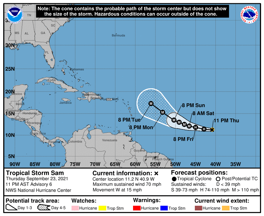
Partially due to an adjustment of the initial
position, the new NHC track forecast has been shifted southward a
bit from the previous forecast, and it lies just south of the TVCA
consensus aid--but not as far to the left as the previously
mentioned southern models.
position, the new NHC track forecast has been shifted southward a
bit from the previous forecast, and it lies just south of the TVCA
consensus aid--but not as far to the left as the previously
mentioned southern models.
7 likes
Visit the Caribbean-Central America Weather Thread where you can find at first post web cams,radars
and observations from Caribbean basin members Click Here
and observations from Caribbean basin members Click Here
-
grapealcoholic
- Category 2
- Posts: 634
- Joined: Tue Aug 10, 2021 3:26 pm
Re: ATL: SAM - Tropical Storm - Discussion
Stormybajan wrote:grapealcoholic wrote:aspen wrote:The NHC is probably a little too conservative with the intensity at 3-5 days out, which is fair — we don’t know exactly how Sam will react to the ~5 kt increase in shear. However, the HWRF and HMON do show a re-intensification phase after Sam’s intensity levels off for 24-48 hours, and it’s undergoing a RI/ERI phase that could bring it to Cat 4 intensity by Saturday. We’ll probably see its peak raised to 115-120 kt sometime tomorrow.
How much ACE would Sam produce by the end of the forecast period if it followed the NHC’s advisory exactly?
If it can get to high Cat 4 by tomorrow night, maybe 30-40?
High end cat 4? lol NHC forecast calls for 105 mph tomorrow 8pm AST. Although a major by then cant be ruled out
SHIPS already gives it a 1/3 chance of getting to Cat 4 in 24 hours, and frankly I think that's an underestimate

0 likes
-
Hurricane Mike
- Category 2
- Posts: 562
- Joined: Tue Apr 10, 2018 7:44 am
Re: ATL: SAM - Tropical Storm - Discussion
11pm Video on Sam
https://www.youtube.com/watch?v=LRiZhflDukg
https://www.youtube.com/watch?v=LRiZhflDukg
0 likes
-
wxman57

- Moderator-Pro Met

- Posts: 22480
- Age: 66
- Joined: Sat Jun 21, 2003 8:06 pm
- Location: Houston, TX (southwest)
Re: ATL: SAM - Tropical Storm - Discussion
I think that the NHC day-5 track point may be about 1.5 deg too far north. Looking more like the center may just clip the far NE Caribbean islands. Their day-4 track point may be about a degree too far north. Not expecting a direct hit on PR, Luis. However, Anguilla and St. Martin/Sint Marteen are possibly in the direct path. It should be tracking NW as it passes.
13 likes
Re: ATL: SAM - Tropical Storm - Discussion
ScottNAtlanta wrote:Shell Mound wrote:Weather Dude wrote:Looks like Sam is exploding. Will likely be a major by midday tomorrow at this rate.
The ongoing spate of (E)RI will almost certainly contribute to eastward shifts in the guidance and allow Sam to miss the Leeward Islands, however narrowly. The strongest EPS and GEFS members have consistently taken Sam to the northeast of the Islands. Given that Sam is intensifying even more rapidly than either these or the intensity guidance indicated, the likelihood of an OTS trajectory increases tremendously. Ridging is not expected to be particularly strong, hence’s Sam relatively slow forward speed through D5. The only factor that will prevent Category-5 status at this point is the marginal thermodynamic environment, but otherwise all other indicators favour yet another powerful annular MH in D3–5. Expect Sam to be a stronger version of Larry.
I don't think that it is certain at all this is going out. The speed at which it is traveling is much more of an issue than how strong it is. If its a 70kt storm or a 120kt storm it is still going to follow the same steering. I think we need to pay very close attention as to whether this is hitting track forecast points and if it is off...which direction
They would not have the same steering, .
0 likes
Personal Forecast Disclaimer:
The posts in this forum are NOT official forecast and should not be used as such. They are just the opinion of the poster and may or may not be backed by sound meteorological data. They are NOT endorsed by any professional institution or storm2k.org. For official information, please refer to the NHC and NWS products.
The posts in this forum are NOT official forecast and should not be used as such. They are just the opinion of the poster and may or may not be backed by sound meteorological data. They are NOT endorsed by any professional institution or storm2k.org. For official information, please refer to the NHC and NWS products.

Re: ATL: SAM - Tropical Storm - Discussion
Is the massive band to the north stealing the show again? It has been firing convection nonstop in recent frames, while hot towers near the center have stopped.
0 likes
-
grapealcoholic
- Category 2
- Posts: 634
- Joined: Tue Aug 10, 2021 3:26 pm
Re: ATL: SAM - Tropical Storm - Discussion
Teban54 wrote:Is the massive band to the north stealing the show again? It has been firing convection nonstop in recent frames, while hot towers near the center have stopped.
Just a pulse down I think
0 likes
Who is online
Users browsing this forum: No registered users and 58 guests