Invest 96L,North Atlantic-Discussions
Moderator: S2k Moderators
-
Brent
- S2K Supporter

- Posts: 37125
- Age: 35
- Joined: Sun May 16, 2004 10:30 pm
- Location: Tulsa Oklahoma
- Contact:
Re: Invest 96L,East of Carolinas-Discussions-Analysis & Imagery
I'm confused as to which one is which... 
0 likes
-
cycloneye

- Admin

- Posts: 139346
- Age: 67
- Joined: Thu Oct 10, 2002 10:54 am
- Location: San Juan, Puerto Rico
Re: Invest 96L,East of Carolinas-Discussions-Analysis & Imagery
Brent wrote:I'm confused as to which one is which...
Is better to have a bunch than to have none.
0 likes

-
storms in NC

- S2K Supporter
- Posts: 2338
- Joined: Thu Jul 28, 2005 2:58 pm
- Location: Wallace,NC 40 miles NE of Wilm
- Contact:
I am having a time to see which is which. They should use a color code on these Topics titles. Like red green so we can see which one we are trying to read.
Last edited by storms in NC on Thu Aug 30, 2007 10:10 am, edited 1 time in total.
0 likes
-
cycloneye
- Admin
- Posts: 139346
- Age: 67
- Joined: Thu Oct 10, 2002 10:54 am
- Location: San Juan, Puerto Rico
Re:
storms in NC wrote:I am having a time to see which is which. They should use a color code on these threads. Like red green so we can see which one we are trying to read.
All the invest threads in the titles are identified with the area where it is.
0 likes


Re: Invest 96L,East of Carolinas-Discussions-Analysis & Imagery
Yeah, I went to work and nothing much was happening and come home and there's four invests. What happens when you run out of floaters?
0 likes
-
storms in NC
- S2K Supporter
- Posts: 2338
- Joined: Thu Jul 28, 2005 2:58 pm
- Location: Wallace,NC 40 miles NE of Wilm
- Contact:
Re: Re:
cycloneye wrote:storms in NC wrote:I am having a time to see which is which. They should use a color code on these threads. Like red green so we can see which one we are trying to read.
All the invest threads in the titles are identified with the area where it is.
Yeah but when you are old and can't see out of one eye and blind in the other it is hard. Like there was two 95. you had to look hard to see which one was which.
I know put the speck on.LOL
0 likes

-
wxman57

- Moderator-Pro Met

- Posts: 22484
- Age: 66
- Joined: Sat Jun 21, 2003 8:06 pm
- Location: Houston, TX (southwest)
Re:
CrazyC83 wrote:50 knot winds? That isn't TD6, but TS Felix perhaps!
Those are cloud motions, winds aloft - not at the surface. It's embedded in the Polar jet stream, thus the strong SW winds aloft. Surface winds are in the 10-20 kt range. Still, it might have a shot at a brief spin up before it's torn apart.
0 likes


-
storms in NC
- S2K Supporter
- Posts: 2338
- Joined: Thu Jul 28, 2005 2:58 pm
- Location: Wallace,NC 40 miles NE of Wilm
- Contact:
-
wxman57
- Moderator-Pro Met
- Posts: 22484
- Age: 66
- Joined: Sat Jun 21, 2003 8:06 pm
- Location: Houston, TX (southwest)
Re: Invest 96L,East of Carolinas-Discussions-Analysis & Imagery
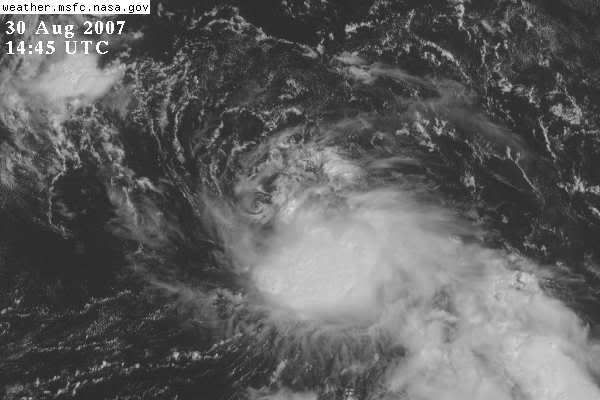
Just snapped a GARP screen shot of 96L. Looks like shear is affecting it now with the upper low to the west. You can see a little vortex has rotated out from beneath the convection. Winds around the disturbance are relatively light (10kts).

0 likes
-
chadtm80

- Category 5

- Posts: 20381
- Age: 43
- Joined: Tue Oct 08, 2002 8:35 am
- Location: East Central Florida
- Contact:
Re:
storms in NC wrote:There is No 95L any more so there is only 4 now
????
http://www.nrlmry.navy.mil/tc-bin/tc_ho ... k_vis/dmsp
0 likes
-
storms in NC
- S2K Supporter
- Posts: 2338
- Joined: Thu Jul 28, 2005 2:58 pm
- Location: Wallace,NC 40 miles NE of Wilm
- Contact:
Re: Re:
chadtm80 wrote:storms in NC wrote:There is No 95L any more so there is only 4 now
????
http://www.nrlmry.navy.mil/tc-bin/tc_ho ... k_vis/dmsp
sorry only 3 at this time
Atlantic Tropical Weather Outlook
--------------------------------------------------------------------------------
000
ABNT20 KNHC 301525 CCA
TWOAT
TROPICAL WEATHER OUTLOOK...CORRECTED
NWS TPC/NATIONAL HURRICANE CENTER MIAMI FL
1130 AM EDT THU AUG 30 2007
SHOWER ACTIVITY ASSOCIATED WITH THE DISORGANIZED NON-TROPICAL AREA
OF LOW PRESSURE A FEW HUNDRED MILES EAST OF THE GEORGIA COAST HAS
DIMINISHED...AND FURTHER DEVELOPMENT IS NOT EXPECTED.
Last edited by storms in NC on Thu Aug 30, 2007 11:32 am, edited 1 time in total.
0 likes


-
cycloneye
- Admin
- Posts: 139346
- Age: 67
- Joined: Thu Oct 10, 2002 10:54 am
- Location: San Juan, Puerto Rico
Re:
BreinLa wrote:Sheeesh I am leaving for south Carolina in the morning what the heck is happening here. GO CAJUNS
Nothing to worrie about as 96L will be pushed Northeast as a front will move it that way.
0 likes

Interesting wording in the TWO though...
A SMALL AREA OF LOW PRESSURE HAS DEVELOPED ABOUT 350 MILES EAST OF
CAPE HATTERAS. THIS SYSTEM...WHICH IS CURRENTLY STATIONARY...IS
EXPECTED TO BEGIN MOVING NORTHEASTWARD LATER TODAY AHEAD OF AN
APPROACHING FRONTAL SYSTEM. THE LOW WILL HAVE A BRIEF OPPORTUNITY
FOR TROPICAL CYCLONE FORMATION BEFORE BECOMING OVERTAKEN BY THE
FRONT IN A COUPLE OF DAYS.
0 likes
-
skysummit

- S2K Supporter
- Posts: 5305
- Age: 48
- Joined: Tue Aug 31, 2004 11:09 pm
- Location: Ponchatoula, LA
- Contact:
Re: Invest 96L,East of Carolinas-Discussions-Analysis & Imagery
TROPICAL CYCLONE GUIDANCE MESSAGE
NWS TPC/NATIONAL HURRICANE CENTER MIAMI FL
1826 UTC THU AUG 30 2007
DISCLAIMER...NUMERICAL MODELS ARE SUBJECT TO LARGE ERRORS.
PLEASE REFER TO NHC OFFICIAL FORECASTS FOR TROPICAL CYCLONE
AND SUBTROPICAL CYCLONE INFORMATION.
ATLANTIC OBJECTIVE AIDS FOR
DISTURBANCE INVEST (AL962007) 20070830 1800 UTC
...00 HRS... ...12 HRS... ...24 HRS. .. ...36 HRS...
070830 1800 070831 0600 070831 1800 070901 0600
LAT LON LAT LON LAT LON LAT LON
BAMS 36.2N 70.0W 37.5N 70.6W 38.8N 70.7W 39.6N 69.3W
BAMD 36.2N 70.0W 37.7N 69.7W 39.9N 68.3W 42.9N 64.8W
BAMM 36.2N 70.0W 37.6N 70.2W 39.2N 69.6W 41.1N 67.0W
LBAR 36.2N 70.0W 37.3N 69.2W 39.2N 67.7W 41.7N 64.8W
SHIP 25KTS 30KTS 36KTS 47KTS
DSHP 25KTS 30KTS 36KTS 47KTS
...48 HRS... ...72 HRS... ...96 HRS. .. ..120 HRS...
070901 1800 070902 1800 070903 1800 070904 1800
LAT LON LAT LON LAT LON LAT LON
BAMS 39.7N 66.0W 37.9N 57.9W 36.3N 53.0W 36.6N 48.3W
BAMD 46.6N 59.9W 53.3N 48.1W 60.0N 32.1W 63.6N 10.0W
BAMM 43.2N 62.3W 46.3N 52.5W 48.2N 43.6W 51.0N 32.8W
LBAR 45.2N 60.0W 53.7N 41.2W .0N .0W .0N .0W
SHIP 56KTS 51KTS 48KTS 42KTS
DSHP 56KTS 51KTS 48KTS 42KTS
...INITIAL CONDITIONS...
LATCUR = 36.2N LONCUR = 70.0W DIRCUR = 0DEG SPDCUR = 3KT
LATM12 = 35.5N LONM12 = 70.2W DIRM12 = 321DEG SPDM12 = 3KT
LATM24 = 34.6N LONM24 = 70.2W
WNDCUR = 25KT RMAXWD = 60NM WNDM12 = 25KT
CENPRS = 1011MB OUTPRS = 1013MB OUTRAD = 120NM SDEPTH = D
RD34NE = 0NM RD34SE = 0NM RD34SW = 0NM RD34NW = 0NM
$$
NNNN
0 likes
-
wxman57
- Moderator-Pro Met
- Posts: 22484
- Age: 66
- Joined: Sat Jun 21, 2003 8:06 pm
- Location: Houston, TX (southwest)
Re: Invest 96L,East of Carolinas-Discussions-Analysis & Imagery
I'm looking at a water vapor loop and I see quite a bit of wind shear building over 96L this afternoon. It may have missed its chance for development. Might not be much left by tomorrow morning.
0 likes
Who is online
Users browsing this forum: No registered users and 6 guests