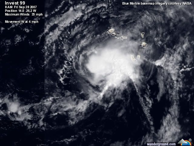
Ex Tropical Depression MELISSA- Discussions & Images

Moderator: S2k Moderators

Message
Author
PhillyWX
Category 1
Category 1
Posts: 494
Joined: Tue Aug 30, 2005 8:54 am
Location: Philly
Contact:

Re: Invest 99L: Cape Verde Islands: Global & BAM Models

#21 Postby PhillyWX » Fri Sep 28, 2007 7:29 am

wxman57 wrote:I think NHC may be underestimating 99L's intensity a bit. Preliminary visible satellite imagery makes it look VERY much like TS Melissa! But it's pure, 100% fish. No doubt about it.

Image


That far north, that far east? Definitely. This storm may not make it to 40 W before turning north.
0 likes   

User avatar
wxman57
Moderator-Pro Met
Moderator-Pro Met
Posts: 22500
Age: 66
Joined: Sat Jun 21, 2003 8:06 pm
Location: Houston, TX (southwest)

Re: Invest 99L: Cape Verde Islands: Discussions & Images

#22 Postby wxman57 » Fri Sep 28, 2007 7:32 am

This is already a TS if I've ever seen one. NHC can either name it now or ignore it for a few days and wait for it to dissipate. It looks far more impressive than either Karen or Lorenzo. Checking my email, I see that the NHC is looking at it closely. They've just re-run the tropical models on it centered near 14N/26.2W. They didn't include an intensity on the runs, though. Perhaps they're considering admitting it's a storm soon? I remember back in 1995 when a "disturbance" developed a clear eye overnight as the NHC was tracking 3-4 other named storms at the time. They described the disturbance as having a "rain-free central area" and upgraded it to a weak TS then gradually to a hurricane. It was clearly already a powerful hurricane near Africa. They just got too busy to notice it.

Image
Last edited by wxman57 on Fri Sep 28, 2007 7:36 am, edited 1 time in total.
0 likes   

User avatar
Thunder44
Category 5
Category 5
Posts: 5922
Age: 43
Joined: Mon Jun 09, 2003 7:53 pm
Location: New York City

Re: Invest 99L: Cape Verde Islands: Global & hurricane Models

#23 Postby Thunder44 » Fri Sep 28, 2007 7:32 am

449
WHXX01 KWBC 281229
CHGHUR
TROPICAL CYCLONE GUIDANCE MESSAGE
NWS TPC/NATIONAL HURRICANE CENTER MIAMI FL
1229 UTC FRI SEP 28 2007

DISCLAIMER...NUMERICAL MODELS ARE SUBJECT TO LARGE ERRORS.
PLEASE REFER TO NHC OFFICIAL FORECASTS FOR TROPICAL CYCLONE
AND SUBTROPICAL CYCLONE INFORMATION.

ATLANTIC OBJECTIVE AIDS FOR

DISTURBANCE INVEST (AL992007) 20070928 1200 UTC

...00 HRS... ...12 HRS... ...24 HRS. .. ...36 HRS...
070928 1200 070929 0000 070929 1200 070930 0000

LAT LON LAT LON LAT LON LAT LON
BAMS 14.0N 26.2W 15.2N 28.2W 16.5N 30.2W 17.8N 32.1W
BAMD 14.0N 26.2W 14.6N 26.9W 15.3N 27.8W 16.2N 28.7W
BAMM 14.0N 26.2W 14.8N 27.3W 15.6N 28.5W 16.4N 29.9W
LBAR 14.0N 26.2W 14.4N 26.7W 15.8N 27.6W 17.7N 28.5W

...48 HRS... ...72 HRS... ...96 HRS. .. ..120 HRS...
070930 1200 071001 1200 071002 1200 071003 1200

LAT LON LAT LON LAT LON LAT LON
BAMS 19.1N 34.2W 21.5N 38.1W 23.3N 41.2W 24.1N 43.2W
BAMD 17.2N 29.7W 19.1N 31.8W 20.7N 33.3W 22.6N 28.3W
BAMM 17.4N 31.5W 19.4N 34.7W 21.2N 37.8W 22.9N 40.0W
LBAR 20.4N 29.0W 26.1N 25.4W 27.5N 14.9W 28.5N 5.3W

...INITIAL CONDITIONS...
LATCUR = 14.0N LONCUR = 26.2W DIRCUR = 270DEG SPDCUR = 4KT
LATM12 = 14.0N LONM12 = 25.0W DIRM12 = 248DEG SPDM12 = 3KT
LATM24 = 14.2N LONM24 = 23.8W
WNDCUR = 30KT RMAXWD = 40NM WNDM12 = 20KT
CENPRS = 1008MB OUTPRS = 1014MB OUTRAD = 175NM SDEPTH = D
RD34NE = 0NM RD34SE = 0NM RD34SW = 0NM RD34NW = 0NM

$$
NNNN


12z models, still says "Disturbance Invest", but winds up 30kts and pressure down to 1008mb.
0 likes   

User avatar
HURAKAN
Professional-Met
Professional-Met
Posts: 46086
Age: 37
Joined: Thu May 20, 2004 4:34 pm
Location: Key West, FL
Contact:

#24 Postby HURAKAN » Fri Sep 28, 2007 7:34 am

Image

loop: http://oiswww.eumetsat.org/SDDI/cgi/lis ... 0#controls

Press play and you will see a blow-up in convection and an expanding outflow. By the way, this is stationary.
0 likes   

User avatar
HURAKAN
Professional-Met
Professional-Met
Posts: 46086
Age: 37
Joined: Thu May 20, 2004 4:34 pm
Location: Key West, FL
Contact:

#25 Postby HURAKAN » Fri Sep 28, 2007 7:41 am

Image
0 likes   

User avatar
HURAKAN
Professional-Met
Professional-Met
Posts: 46086
Age: 37
Joined: Thu May 20, 2004 4:34 pm
Location: Key West, FL
Contact:

#26 Postby HURAKAN » Fri Sep 28, 2007 7:53 am

Image
0 likes   

User avatar
punkyg
Category 2
Category 2
Posts: 770
Joined: Mon Apr 23, 2007 7:37 pm
Location: sanford florida

Re: Invest 99L: Cape Verde Islands: Discussions & Images

#27 Postby punkyg » Fri Sep 28, 2007 7:57 am

wxman57 wrote:This is already a TS if I've ever seen one. NHC can either name it now or ignore it for a few days and wait for it to dissipate. It looks far more impressive than either Karen or Lorenzo. Checking my email, I see that the NHC is looking at it closely. They've just re-run the tropical models on it centered near 14N/26.2W. They didn't include an intensity on the runs, though. Perhaps they're considering admitting it's a storm soon? I remember back in 1995 when a "disturbance" developed a clear eye overnight as the NHC was tracking 3-4 other named storms at the time. They described the disturbance as having a "rain-free central area" and upgraded it to a weak TS then gradually to a hurricane. It was clearly already a powerful hurricane near Africa. They just got too busy to notice it.

Image

Do you have any pictures of that TS? and what name did it have.
0 likes   

User avatar
WmE
Category 2
Category 2
Posts: 696
Age: 35
Joined: Sat Jun 17, 2006 11:23 am
Location: Vienna, Austria

#28 Postby WmE » Fri Sep 28, 2007 8:00 am

I would guess it was Luis back in 1995, wxman57 correct me if I'm wrong.

edited
Last edited by WmE on Fri Sep 28, 2007 8:03 am, edited 2 times in total.
0 likes   

User avatar
cycloneye
Admin
Admin
Posts: 139520
Age: 67
Joined: Thu Oct 10, 2002 10:54 am
Location: San Juan, Puerto Rico

Re: Invest 99L: Cape Verde Islands: Discussions & Images

#29 Postby cycloneye » Fri Sep 28, 2007 8:01 am

28/1145 UTC 13.7N 25.7W T1.5/1.5 99L -- Atlantic Ocean
0 likes   

HenkL
S2K Supporter
S2K Supporter
Posts: 2401
Joined: Fri Sep 10, 2004 5:33 pm
Location: Groningen, The Netherlands
Contact:

#30 Postby HenkL » Fri Sep 28, 2007 8:02 am

At 12Z a British ship (C6JD7 - Wren Arrow) reported 29 kt winds from the NE. The ship was located 15.9N 25.9W.

BBXX
C6JD7 28121 99159 70259 41598 20515 10265 20241 40137 51010 70311
81778 22213 00260 21408 316// 40802 5//// 80248=
0 likes   

User avatar
drezee
S2K Supporter
S2K Supporter
Posts: 3644
Joined: Mon Jun 09, 2003 12:49 pm
Location: FL

Re: Invest 99L: Cape Verde Islands: Discussions & Images

#31 Postby drezee » Fri Sep 28, 2007 8:11 am

wxman57 wrote:They've just re-run the tropical models on it centered near 14N/26.2W. They didn't include an intensity on the runs, though. Perhaps they're considering admitting it's a storm soon?


They did include intensity. Look at the bottom of the model:

WNDCUR = 30KT RMAXWD = 40NM
0 likes   

User avatar
wxman57
Moderator-Pro Met
Moderator-Pro Met
Posts: 22500
Age: 66
Joined: Sat Jun 21, 2003 8:06 pm
Location: Houston, TX (southwest)

Re:

#32 Postby wxman57 » Fri Sep 28, 2007 8:13 am

WmE wrote:I would guess it was Luis back in 1995, wxman57 correct me if I'm wrong.

edited


No, it wasn't Luis. Luis didn't look like a hurricane near the Cape Verde islands. It may have Noel. I can't tell because Unisys's web page is down.
0 likes   

User avatar
chadtm80
Category 5
Category 5
Posts: 20381
Age: 43
Joined: Tue Oct 08, 2002 8:35 am
Location: East Central Florida
Contact:

Re: Invest 99L: Cape Verde Islands: Discussions & Images

#33 Postby chadtm80 » Fri Sep 28, 2007 8:16 am

0 likes   

User avatar
wxman57
Moderator-Pro Met
Moderator-Pro Met
Posts: 22500
Age: 66
Joined: Sat Jun 21, 2003 8:06 pm
Location: Houston, TX (southwest)

Re: Invest 99L: Cape Verde Islands: Discussions & Images

#34 Postby wxman57 » Fri Sep 28, 2007 8:18 am

drezee wrote:
wxman57 wrote:They've just re-run the tropical models on it centered near 14N/26.2W. They didn't include an intensity on the runs, though. Perhaps they're considering admitting it's a storm soon?


They did include intensity. Look at the bottom of the model:

WNDCUR = 30KT RMAXWD = 40NM


I was thinking the other day (yesterday, in fact). Perhaps there needs to be a group that's separate from the NHC which decides the current status of a system rather than the same group that's forecasting development and intensification (or dissipation). This sure looks like a TS today, but the NHC wasn't even calling it an invest until it looked like a TS. They clearly missed it, and without another group to say "yes, it IS a TS", the NHC can just ignore it or say it's a wave. It makes it easier on forecast verification if the forecaster decides whether a disturbance is a storm or not.

But in the grand scheme of things (in defense of the NHC - they're a great bunch of forecasters), it's insignificant. It'll certainly never threaten any of the people who the NHC are responsible for protecting. It's not their job to make sure a storm isn't missed in the hurricane database.
0 likes   

User avatar
KWT
Category 5
Category 5
Posts: 31391
Joined: Tue Aug 17, 2004 11:02 am
Location: UK!!!

#35 Postby KWT » Fri Sep 28, 2007 8:43 am

Really though they shouldn't miss any systems, they surely have enough people to see something as good looking as this, I do know there are other more important systems out there but it sure looks like a tropical storm and you really can't miss it to be honest!

I'm actually going to watch this one rather closely as it could well easily recurve into Europe depending on the strength of the ridging and if it develops at all then its going t5o shake up the set-up up here, possibly quite a lot if it can undercut the upper high.
0 likes   

PhillyWX
Category 1
Category 1
Posts: 494
Joined: Tue Aug 30, 2005 8:54 am
Location: Philly
Contact:

Re: Re:

#36 Postby PhillyWX » Fri Sep 28, 2007 8:46 am

wxman57 wrote:
WmE wrote:I would guess it was Luis back in 1995, wxman57 correct me if I'm wrong.

edited


No, it wasn't Luis. Luis didn't look like a hurricane near the Cape Verde islands. It may have Noel. I can't tell because Unisys's web page is down.


How about Humberto? That was upgraded in 5 advisories to a 'cane and was east of 40 W at the time of upgrade.

http://www.nhc.noaa.gov/archive/storm_w ... al0995.001 (first disco)
http://www.nhc.noaa.gov/archive/storm_w ... al0995.005 (upgrade to cane disco)
0 likes   

User avatar
HURAKAN
Professional-Met
Professional-Met
Posts: 46086
Age: 37
Joined: Thu May 20, 2004 4:34 pm
Location: Key West, FL
Contact:

#37 Postby HURAKAN » Fri Sep 28, 2007 8:48 am

Melissa????

Image
0 likes   

User avatar
wxman57
Moderator-Pro Met
Moderator-Pro Met
Posts: 22500
Age: 66
Joined: Sat Jun 21, 2003 8:06 pm
Location: Houston, TX (southwest)

Re: Invest 99L: Cape Verde Islands: Discussions & Images

#38 Postby wxman57 » Fri Sep 28, 2007 8:50 am

Well, at least they're calling it TD 14 now (though they could call it a TS at 10AM CDT):

DISTURBANCE FOURTEEN (AL142007) 20070928 1200 UTC

...00 HRS... ...12 HRS... ...24 HRS. .. ...36 HRS...
070928 1200 070929 0000 070929 1200 070930 0000

LAT LON LAT LON LAT LON LAT LON
BAMS 14.0N 26.2W 15.2N 28.2W 16.5N 30.2W 17.8N 32.1W
BAMD 14.0N 26.2W 14.6N 26.9W 15.3N 27.8W 16.2N 28.7W
BAMM 14.0N 26.2W 14.8N 27.3W 15.6N 28.5W 16.4N 29.9W
LBAR 14.0N 26.2W 14.4N 26.7W 15.8N 27.6W 17.7N 28.5W
Last edited by wxman57 on Fri Sep 28, 2007 8:52 am, edited 1 time in total.
0 likes   

User avatar
Thunder44
Category 5
Category 5
Posts: 5922
Age: 43
Joined: Mon Jun 09, 2003 7:53 pm
Location: New York City

Re: Invest 99L: Cape Verde Islands: Discussions & Images

#39 Postby Thunder44 » Fri Sep 28, 2007 8:51 am

The NHC didn't "miss" this system. They've been talking about in the TWO for last few days, before they labled it invest this morning. I do agree they are now hesitating to upgrade this system.
0 likes   

User avatar
KWT
Category 5
Category 5
Posts: 31391
Joined: Tue Aug 17, 2004 11:02 am
Location: UK!!!

#40 Postby KWT » Fri Sep 28, 2007 8:53 am

Not really that surprising that its been upped to TD14, it does look pretty good. Whats the set-up like ahead of it?
0 likes   


Return to “2007”

Who is online

Users browsing this forum: No registered users and 7 guests