Invest 94L,Near Windwards-Discussions

Moderator: S2k Moderators

Message
Author
User avatar
GeneratorPower
S2K Supporter
S2K Supporter
Posts: 1648
Age: 44
Joined: Sun Dec 18, 2005 11:48 pm
Location: Huntsville, AL

Re:

#81 Postby GeneratorPower » Tue Aug 28, 2007 11:12 am

hurricanetrack wrote:Ok, the 12Z GFS is coming out and it all but destroys this system- once again. How could it develop if the GFS, a great global model, can't even develop it within 96 hours?

I know people want to have something to track, perhaps none more than me, but time after time these invests turn out to be nothing more than a bunch of late nights waiting for nothing.

We have a lot of smart people on this forum. Let's get some input as to why one of the best global models, certainly in the short term, does not develop 94L. There's gotta be a reason other than "the GFS is poor in the cyclogenesis stage". It certainly was not poor with 92L which looked far better than this system.

Just want to make sure people don't get too worked up over something that has almost no model support. Save your energy for times when bigger and better invests come down the pipes!

Just my thoughts on a hot, muggy SE NC day.


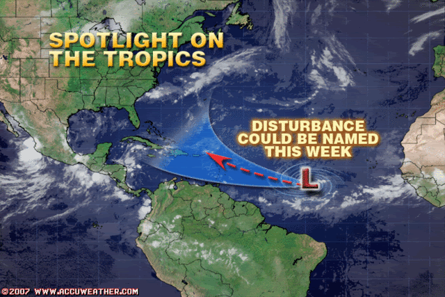
Well, Mark, we have at least one pro-met opinion of a 30% chance of development, so that's about 1-in-3. So it's worth watching. I enjoy watching the ones that don't develop, too, because I learn what to NOT to look for.

Besides, it looks pretty neat on satellite, regardless of poor model support, and it's that same old desire to track the next Katrina from its very start as a raindrop.
0 likes   

sevenleft
Category 1
Category 1
Posts: 315
Joined: Sat Aug 05, 2006 2:36 pm

Re: Invest 94L in Central Atlantic-Discussions-Analysis-Imagery

#82 Postby sevenleft » Tue Aug 28, 2007 11:13 am

Why the hell is anyone using the terms great and GFS together?
0 likes   

User avatar
DESTRUCTION5
Category 5
Category 5
Posts: 4391
Age: 42
Joined: Wed Sep 03, 2003 11:25 am
Location: Stuart, FL

Re: Invest 94L in Central Atlantic-Discussions-Analysis-Imagery

#83 Postby DESTRUCTION5 » Tue Aug 28, 2007 11:14 am

sevenleft wrote:Why the hell is anyone using the terms great and GFS together?


Because it was GREAT for 1 storm this year...
0 likes   

sevenleft
Category 1
Category 1
Posts: 315
Joined: Sat Aug 05, 2006 2:36 pm

Re: Invest 94L in Central Atlantic-Discussions-Analysis-Imagery

#84 Postby sevenleft » Tue Aug 28, 2007 11:15 am

DESTRUCTION5 wrote:
sevenleft wrote:Why the hell is anyone using the terms great and GFS together?


Because it was GREAT for 1 storm this year...
The GFS was ok. The Euro was great (after Dean was strong enough to be initialized decently).
0 likes   

User avatar
ConvergenceZone
Category 5
Category 5
Posts: 4833
Joined: Fri Jul 29, 2005 1:40 am
Location: Northern California

Re: Invest 94L in Central Atlantic-Discussions-Analysis-Imagery

#85 Postby ConvergenceZone » Tue Aug 28, 2007 11:16 am

ea, I'm not bullish on this system either, especially since the models are either not grabbing
it or losing it later. It doesn't look good at this point. They are probably seeing something
we aren't as usual.
0 likes   

User avatar
AJC3
Admin
Admin
Posts: 3876
Age: 60
Joined: Tue Aug 31, 2004 7:04 pm
Location: West Melbourne, Florida
Contact:

Re: Re:

#86 Postby AJC3 » Tue Aug 28, 2007 11:18 am

wxman57 wrote: Yeah, could be. I see on the Penn State E-wall 00hr map (see link below) that there's a vorticity center near there last evening. But it moves the system so slowly westward. 5 days to go just over 1000 miles is just over 10 kts.

http://www.meteo.psu.edu/~gadomski/ECMWFTROPATL_0z/f00.gif


Agreed. The forecast positions for the H85 vort center look much too slow...especially early on in the forecast cycle (2-3degrees/day...*cough cough*)

init 00Z/28...10N38W
H24 00Z/29...10N40W
H48 00Z/30...10N43W
H72 00Z/31...12N47W
H96 00Z/01...12.5N50W
H120 00Z/02...14N55W
H144 00Z/03...15N59.5W
H168 00Z/04...17N62.5W
0 likes   

User avatar
dixiebreeze
S2K Supporter
S2K Supporter
Posts: 5140
Joined: Wed Sep 03, 2003 5:07 pm
Location: crystal river, fla.

Re: Invest 94L in Central Atlantic-Discussions-Analysis-Imagery

#87 Postby dixiebreeze » Tue Aug 28, 2007 11:19 am

TAFB drops the low after 24 hrs.
0 likes   

User avatar
cycloneye
Admin
Admin
Posts: 139409
Age: 67
Joined: Thu Oct 10, 2002 10:54 am
Location: San Juan, Puerto Rico

Re:

#88 Postby cycloneye » Tue Aug 28, 2007 11:19 am

hurricanetrack wrote:Ok, the 12Z GFS is coming out and it all but destroys this system- once again. How could it develop if the GFS, a great global model, can't even develop it within 96 hours?

I know people want to have something to track, perhaps none more than me, but time after time these invests turn out to be nothing more than a bunch of late nights waiting for nothing.

We have a lot of smart people on this forum. Let's get some input as to why one of the best global models, certainly in the short term, does not develop 94L. There's gotta be a reason other than "the GFS is poor in the cyclogenesis stage". It certainly was not poor with 92L which looked far better than this system.

Just want to make sure people don't get too worked up over something that has almost no model support. Save your energy for times when bigger and better invests come down the pipes!

Just my thoughts on a hot, muggy SE NC day.


What you want is for the pro mets to chim in about why the global models are performing poorly with this system right? I am sure that any of them will answer this important question and you are not alone as I ask that too.
0 likes   

User avatar
'CaneFreak
Category 5
Category 5
Posts: 1475
Joined: Mon Jun 05, 2006 10:50 am
Location: New Bern, NC

#89 Postby 'CaneFreak » Tue Aug 28, 2007 11:19 am

Well, like the saying goes, "If none of the models develop it, then it will probably develop, if all of the models develop it, it will probably develop, but if only one or a handful of them develop, then it will probably not develop."
0 likes   

User avatar
wxman57
Moderator-Pro Met
Moderator-Pro Met
Posts: 22484
Age: 66
Joined: Sat Jun 21, 2003 8:06 pm
Location: Houston, TX (southwest)

Re: Invest 94L in Central Atlantic-Discussions-Analysis-Imagery

#90 Postby wxman57 » Tue Aug 28, 2007 11:21 am

Also of note (as far as the 12Z GFS) is that it moves the vorticity center into the eastern Caribbean by 12Z Friday, not on Sunday. By the way, a 30% chance of development = a 70% chance it won't develop. Still doesn't look too impressive, but it has a shot at spinning up.
0 likes   

User avatar
hurricanetrack
HurricaneTrack.com
HurricaneTrack.com
Posts: 1776
Joined: Tue Dec 02, 2003 10:46 pm
Location: Wilmington, NC
Contact:

#91 Postby hurricanetrack » Tue Aug 28, 2007 11:21 am

Oh, I love tracking them all too- but have been burned too often on a system that seems it could develop yet few of the major models support it.

I am not dismissing 94L completely, but the GFS is a very modern model that seems to be doing quite well this season. Go with the trends, right? If GFS has done well to date, stick with it.

Here is another way to look at my harping on this "no model support" issue.

We have 94L out there. It looks better than it did yesterday, we are all excited about it, it is late August, water temps are warm, there is no SAL to speak of, we're in an active period for increased Atlantic hurricanes, we're told this season will be very active and yet- why do most models (perhaps it is all of the major models) NOT develop this system? That's what I am trying to get to the bottom of. Not trying to prove the GFS right or any other model. Like generatorpower said, I wish to learn to, and I want to know other's thoughts about WHY the models "don't like" this system. The more we understand why certain things happen (or don't happen) the more we can appreciate this phenomenon.

So, with all of the seemingly positives going for this 94L, why no model support?
0 likes   

User avatar
GeneratorPower
S2K Supporter
S2K Supporter
Posts: 1648
Age: 44
Joined: Sun Dec 18, 2005 11:48 pm
Location: Huntsville, AL

#92 Postby GeneratorPower » Tue Aug 28, 2007 11:24 am

Mark, what about the old saying that there is poor input data way out in the Central Atlantic. Seems plausible to me that there are favorible conditions driving this development that aren't being sampled at all.

That would be a big reason.
0 likes   

Sanibel
Category 5
Category 5
Posts: 10348
Joined: Mon Aug 30, 2004 11:06 pm
Location: Offshore SW Florida

Re: Invest 94L in Central Atlantic-Discussions-Analysis-Imagery

#93 Postby Sanibel » Tue Aug 28, 2007 11:29 am

From what I see of 2007, conditions support formation if the system can get on the Quickscat radar. We'll see if I'm wrong since this one isn't very promising looking.
0 likes   

rockyman
Category 5
Category 5
Posts: 1967
Joined: Thu Jun 26, 2003 12:24 pm
Location: Dauphin Island, AL

Re: Invest 94L in Central Atlantic-Discussions-Analysis-Imagery

#94 Postby rockyman » Tue Aug 28, 2007 11:29 am

DESTRUCTION5 wrote:
sevenleft wrote:Why the hell is anyone using the terms great and GFS together?


Because it was GREAT for 1 storm this year...


I have a broken Rolex on my dresser..and it is 100% accurate for exactly 2 milliseconds out of every day (ok ok, you caught me...it's actually a Timex haha)

I think it is WAY too early to decide about the future of this system...and it is beyond foolhardy to proclaim that a system way out in the Atlantic will not develop simply because the "models say it won't"...look at the synoptics and make an educated guess...but don't just rely on models this early in the game.

By the way, my comments are NOT directed at any individual poster...just a general rule of thumb that I go by
0 likes   

User avatar
HURAKAN
Professional-Met
Professional-Met
Posts: 46086
Age: 37
Joined: Thu May 20, 2004 4:34 pm
Location: Key West, FL
Contact:

#95 Postby HURAKAN » Tue Aug 28, 2007 11:44 am

Image
0 likes   

User avatar
skysummit
S2K Supporter
S2K Supporter
Posts: 5305
Age: 48
Joined: Tue Aug 31, 2004 11:09 pm
Location: Ponchatoula, LA
Contact:

#96 Postby skysummit » Tue Aug 28, 2007 11:45 am

Well, good ole Accu has taken out the possibility of a South American track with that graphic! LOL
0 likes   

User avatar
DESTRUCTION5
Category 5
Category 5
Posts: 4391
Age: 42
Joined: Wed Sep 03, 2003 11:25 am
Location: Stuart, FL

#97 Postby DESTRUCTION5 » Tue Aug 28, 2007 11:45 am

:uarrow:

Well they toss out the SA idea...LOL
0 likes   

User avatar
storms in NC
S2K Supporter
S2K Supporter
Posts: 2338
Joined: Thu Jul 28, 2005 2:58 pm
Location: Wallace,NC 40 miles NE of Wilm
Contact:

#98 Postby storms in NC » Tue Aug 28, 2007 11:46 am

Looks as if the Islands and Mexico are in for it this year. It is like a race to see how long it takes to get from one end to the other. I mean that these waves and TC head almost due west. No cruvers to these things.

any news on the ridges weaking any?
0 likes   

User avatar
cycloneye
Admin
Admin
Posts: 139409
Age: 67
Joined: Thu Oct 10, 2002 10:54 am
Location: San Juan, Puerto Rico

Re:

#99 Postby cycloneye » Tue Aug 28, 2007 11:48 am

HURAKAN wrote:Image


HURAKAN,what is their reasoning for having that track?
0 likes   

User avatar
storms in NC
S2K Supporter
S2K Supporter
Posts: 2338
Joined: Thu Jul 28, 2005 2:58 pm
Location: Wallace,NC 40 miles NE of Wilm
Contact:

Re: Invest 94L in Central Atlantic-Discussions-Analysis-Imagery

#100 Postby storms in NC » Tue Aug 28, 2007 11:52 am

Was told not to post Very sorry you all

Deb
Last edited by storms in NC on Tue Aug 28, 2007 1:22 pm, edited 1 time in total.
0 likes   


Return to “2007”

Who is online

Users browsing this forum: No registered users and 4 guests