INVEST 97L: Near Puerto Rico :Discussions & Images
Moderator: S2k Moderators
Re: INVEST 97L : East of Windwards : Discussion & Images
what's up with the model tracks for 96L and 97L on the home page? They look to be exactly the same.
0 likes
Re: INVEST 97L : East of Windwards : Discussion & Images
The system continues to look blown open yet still retains a deep convection bank in its south quadrant. So it will either bust open or form deeply if it wraps that energy.
0 likes
- Gustywind
- Category 5

- Posts: 12334
- Joined: Mon Sep 03, 2007 7:29 am
- Location: Baie-Mahault, GUADELOUPE
Note that we 'ere in yellow ALERT in GUADELOUPE like MARTINIQUA at 6 PM, we should experience strong showers and big thunderstorms tommorow night or higher according to the latest forecasts by MeteoFrance! We continue to monitor closely this perturbed area showing always signs of organization approaching ours islands, this could refire at any time given the lastest from the TWO:roll:
A BROAD AREA OF LOW PRESSURE ASSOCIATED WITH A TROPICAL WAVE IS
LOCATED ABOUT 300 MILES EAST OF THE WINDWARD ISLANDS. THIS SYSTEM
HAS CHANGED LITTLE IN ORGANIZATION TODAY...BUT COULD STILL DEVELOP
INTO A TROPICAL DEPRESSION DURING THE NEXT DAY OR SO AS IT MOVES
WEST-NORTHWESTWARD TOWARD THE WINDWARD ISLANDS.
0 likes
- HurricaneMaster_PR
- Category 2

- Posts: 795
- Joined: Tue Jul 22, 2003 6:23 pm
- Location: San Juan, Puerto Rico
Re: INVEST 97L : East of Windwards : Discussion & Images
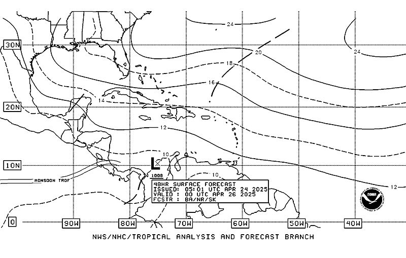
TAFB Surface Forecast in the next 48 hours...It losses the low at 72 hours..


0 likes
- Gustywind
- Category 5

- Posts: 12334
- Joined: Mon Sep 03, 2007 7:29 am
- Location: Baie-Mahault, GUADELOUPE
Latest from NRL site: 10,9 N 56,4 W 1009 hpa 25kts 2245 UTC
http://www.nrlmry.navy.mil/tc-bin/tc_ho ... rovap/dmsp
http://www.nrlmry.navy.mil/tc-bin/tc_ho ... rovap/dmsp
0 likes
- Gustywind
- Category 5

- Posts: 12334
- Joined: Mon Sep 03, 2007 7:29 am
- Location: Baie-Mahault, GUADELOUPE
Re:
Vortex wrote:NRL 10.9/56.4 2245utc
Intense thunderstorms firing over the estimated center as we speak...
Yes tkanks Vortex for the info
0 likes
-
Derek Ortt
- Gustywind
- Category 5

- Posts: 12334
- Joined: Mon Sep 03, 2007 7:29 am
- Location: Baie-Mahault, GUADELOUPE
Re:
Vortex wrote:Barbados
Winds have been E most of the day. Late this afternoon winds became ENE and now NE. Also, pressures are fairly low..runing 29.83 as of 6pm.
Barbados will be an interesting point of reference to follow this evening...
Vortex very interresting but just for the info i've noticed that all the pressures are fairly low in all stations...from Barbados, St Vincent, Ste Lucia, Dominiqua , Guadeloupe: all indicating pressure at 1011 hpa...
http://stormcarib.com/guide.htm#strike
0 likes
- gatorcane
- S2K Supporter

- Posts: 23499
- Age: 46
- Joined: Sun Mar 13, 2005 3:54 pm
- Location: Boca Raton, FL
Re: INVEST 97L : East of Windwards : Discussion & Images
convection continues to become better organized tonight. Looks like we will see this form into our next depression soon as it continues to move WNW. Expect models to shift some to the right and aim more at the SE Bahamas as the energy has shifted farther north.


0 likes
- Gustywind
- Category 5

- Posts: 12334
- Joined: Mon Sep 03, 2007 7:29 am
- Location: Baie-Mahault, GUADELOUPE
000
AXNT20 KNHC 232357
TWDAT
TROPICAL WEATHER DISCUSSION
NWS TPC/NATIONAL HURRICANE CENTER MIAMI FL
805 PM EDT SUN SEP 23 2007
TROPICAL WEATHER DISCUSSION FOR NORTH AMERICA...CENTRAL
AMERICA...THE GULF OF MEXICO...THE CARIBBEAN SEA...NORTHERN
SECTIONS OF SOUTH AMERICA...AND THE ATLANTIC OCEAN TO THE
AFRICAN COAST FROM THE EQUATOR TO 32N. THE FOLLOWING INFORMATION
IS BASED ON SATELLITE IMAGERY...METEOROLOGICAL ANALYSIS...
WEATHER OBSERVATIONS...AND RADAR.
BASED ON 1800 UTC SURFACE ANALYSIS AND SATELLITE IMAGERY THROUGH
2315 UTC.
...SPECIAL FEATURE...
A WELL DEFINED TROPICAL WAVE IS LOCATED ALONG 56W OR ABOUT 300
NM E OF THE WINDWARD ISLANDS. THIS WAVE IS FAIRLY ACTIVE GENERATING CLUSTERS OF WIDELY SCATTERED MODERATE CONVECTION IS
FROM 7N-14N BETWEEN 53W-58W. THIS SYSTEM IS SHOWING SIGNS OF
ORGANIZING AND IT COULD DEVELOP INTO A TROPICAL DEPRESSION OVER THE NEXT DAY OR SO AS IT APPROACHES THE WINDWARD ISLANDS.
REGARDLESS OF
DEVELOPMENT...ASSOCIATED SHOWERS
AND TSTMS WILL BEGIN TO SPREAD ACROSS THOSE ISLANDS LATER TONIGHT AND TOMORROW.
Keep watching it

0 likes
- gatorcane
- S2K Supporter

- Posts: 23499
- Age: 46
- Joined: Sun Mar 13, 2005 3:54 pm
- Location: Boca Raton, FL
Re:
Vortex wrote:All available globals(CMC,NOGAPS,GFS,EURO) take at minimum organized convection NW towards PR and then W/WNW towards the bahamas
VS
Suite of Hurricane models(minus GFDL) offer a different solution and take the system wnw through the carribean..
Vortex thanks for the update, IF (and that is a BIG IF) the shear relaxes this time things could get interesting for the islands and for the Bahamas and maybe even South Florida later this week.
Keep in mind Ingrid's eyes were also set on South Florida but somehow unusually strong ULL winds ripped her apart before she made it here.
0 likes
Who is online
Users browsing this forum: No registered users and 5 guests


