TD Six-E=TS Cosme=TD Cosme in EPAC,CPAC
Moderator: S2k Moderators
-
Category 5

- Category 5

- Posts: 10074
- Age: 34
- Joined: Sun Feb 11, 2007 10:00 pm
- Location: New Brunswick, NJ
- Contact:


-
Andrew92

- S2K Supporter

- Posts: 3247
- Age: 40
- Joined: Mon Jun 16, 2003 12:35 am
- Location: Phoenix, Arizona
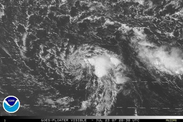
Okay...two plus days of northwesterly vertical shear on the order of
20 to 25 kt has finally done its job. The low level circulation
center of Cosme has at last separated itself from the deep
convection...something it could never quite accomplish until now.
There are still a few single cells east of the center...but they
are far enough away that both SAB and phfo declared Cosme
unclassifiable. Some convection may in the future pop up closer to
the center...but based on what has happened over the last 12
hours...we can expect the convection to not last very long.
Cosme is moving to the west...and will continue to do so through 48
hours. The deep layer easterly flow south of the North Pacific high
and subtropical ridge will continue to rule the day.
As one can see below...forecast intensities remain at 25 kt. This is
to take into account the possibility that the shear will decrease
and sea surface temperatures will increase.
Cosme will pass about 40 nm south of Johnston Island during the next
6 hours. It will be close enough that the atoll will see strong
winds and heavy rain.
This is the last advisory from cphc on Cosme unless the system
regenerates. For future information on the remnant low...please see
the High Seas Forecast issued by the National Weather Service
Honolulu forecast office...under WMO header fzpn40 phfo.
Forecast positions and Max winds
initial 23/0300z 16.1n 169.2w 25 kt
12hr VT 23/1200z 16.2n 172.1w 25 kt...dissipating
24hr VT 24/0000z 16.5n 175.8w 25 kt...remnant low
36hr VT 24/1200z 16.9n 179.5w 25 kt...remnant low
48hr VT 25/0000z 17.4n 178.0e 25 kt...remnant low
72hr VT 26/0000z...dissipated
$$
forecaster Craig
'Bout time. See ya in 2013.
0 likes
-
HURAKAN

- Professional-Met

- Posts: 46086
- Age: 37
- Joined: Thu May 20, 2004 4:34 pm
- Location: Key West, FL
- Contact:
Re:
TAKE 2:
23/0000 UTC 16.1N 168.3W T1.0/1.5 COSME -- Central Pacific Ocean
HURAKAN wrote:HASTA LA VISTA, SEE YOU ON 2013.
21/1200 UTC 16.1N 157.5W T1.5/2.5 COSME -- Central Pacific Ocean
Is going down!!!
23/0000 UTC 16.1N 168.3W T1.0/1.5 COSME -- Central Pacific Ocean
0 likes

Re: Tropical Depression Cosme in Central Pacific
I think I disagree a bit on this one. It looks the same as it did 28 hours ago and even a tad better. I don't see why they said the convection is removed from the center, as it has been for quite a while now, as a reason to declare it finished. Here's hoping to regeneration  .
.
0 likes

-
cycloneye

- Admin

- Posts: 139068
- Age: 67
- Joined: Thu Oct 10, 2002 10:54 am
- Location: San Juan, Puerto Rico
Re: TD Six-E=TS Cosme=TD Cosme in EPAC,CPAC
If there are new advisorys issued on Cosme,then a new thread will be made in the active storms forum.
0 likes
Re: TD Six-E=TS Cosme=TD Cosme in EPAC,CPAC
It's still going pretty good but the CPHC is not doing anything and is saying "it's a weakening low". I certainly don't agree  . It's most likely still a TD right now because I can still see the LLC and way more convection then before.
Is there a reason for that? Redevelopment will surely occur if that happens, look how good it's been fighting so far.
CPHC wrote:400 PM HST MON JUL 23 2007
FOR THE CENTRAL NORTH PACIFIC...BETWEEN 140W AND 180
A weakening low pressure system, the remnant of tropical depression Cosme, was centered about 1150 miles west-southwest of Honolulu. The low was moving west at 20 mph. Isolated thunderstorms continue to develop within 100 miles of the center of the low. Wind shear will diminish over the next 48 hours, however redevelopment is not expected.
Elsewhere, no tropical cyclones are expected through Wednesday afternoon.
Is there a reason for that?
0 likes
-
HURAKAN
- Professional-Met
- Posts: 46086
- Age: 37
- Joined: Thu May 20, 2004 4:34 pm
- Location: Key West, FL
- Contact:
Re: TD Six-E=TS Cosme=TD Cosme in EPAC,CPAC
1 ... 2 ... 3 ... WOW!!!
24/1200 UTC 15.6N 178.1W T2.5/2.5 COSME -- Central Pacific Ocean
WPAC bound!
24/1200 UTC 15.6N 178.1W T2.5/2.5 COSME -- Central Pacific Ocean
WPAC bound!
0 likes
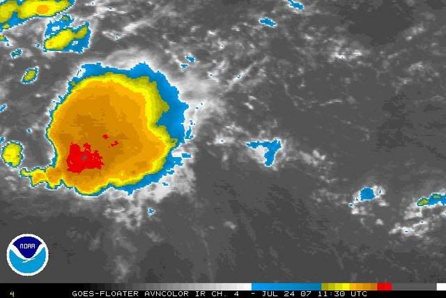
THE REMNANT CIRCULATION OF TD 06E PREVIOUSLY LOCATED
NEAR 15.7N 176.8W, IS NOW LOCATED NEAR 15.6N 178.0W, APPROXIMATELY
910 NM EAST-SOUTHEAST OF WAKE ISLAND. ANIMATED INFRARED SATELLITE
IMAGERY DEPICTS FLARING CONVECTION NEAR THE LOW LEVEL CIRCULATION
CENTER (LLCC). RECENT QUIKSCAT AND ASCAT IMAGES DEPICT A WAVE
FEATURE, BUT PREVIOUS MULTISPECTRAL IMAGERY AND A RECENT 241011Z
TRMM MICROWAVE SATELLITE IMAGE CONFIRM A PARTIALLY-EXPOSED LLCC WITH
IMPROVED DEEP CONVECTION. THE REMNANT CIRCULATION SHOULD CROSS 180
DEGREES LONGITUDE AND INTO THE WESTERN PACIFIC WITHIN THE NEXT 06
TO 12 HOURS. UPPER LEVEL ANALYSIS REVEALS MODERATE VERTICAL WIND
SHEAR AND GOOD UPPER LEVEL DIVERGENCE. MAXIMUM SUSTAINED SURFACE
WINDS ARE ESTIMATED AT 15 TO 20 KNOTS. MINIMUM SEA LEVEL PRESSURE
IS ESTIMATED TO BE NEAR 1006 MB. BASED UPON THE INCREASING DEEP
CONVECTION NEAR THE LLCC, BUT MARGINAL UPPER LEVEL ENVIRONMENT,
THE POTENTIAL FOR THE DEVELOPMENT OF A SIGNIFICANT TROPICAL CYCLONE
WITHIN THE NEXT 24 HOURS IS POOR.
0 likes
WPac: Ex-06E Cosme JTWC: Poor
Since there are no active advisories, and the main thread is in the archive, I think we should use a new thread to discuss the "new" 'INVEST' stage of Cosme, as it enters the WPac.
THE REMNANT CIRCULATION OF TD 06E PREVIOUSLY LOCATED
NEAR 15.7N 176.8W, IS NOW LOCATED NEAR 15.6N 178.0W, APPROXIMATELY
910 NM EAST-SOUTHEAST OF WAKE ISLAND. ANIMATED INFRARED SATELLITE
IMAGERY DEPICTS FLARING CONVECTION NEAR THE LOW LEVEL CIRCULATION
CENTER (LLCC). RECENT QUIKSCAT AND ASCAT IMAGES DEPICT A WAVE
FEATURE, BUT PREVIOUS MULTISPECTRAL IMAGERY AND A RECENT 241011Z
TRMM MICROWAVE SATELLITE IMAGE CONFIRM A PARTIALLY-EXPOSED LLCC WITH
IMPROVED DEEP CONVECTION. THE REMNANT CIRCULATION SHOULD CROSS 180
DEGREES LONGITUDE AND INTO THE WESTERN PACIFIC WITHIN THE NEXT 06
TO 12 HOURS. UPPER LEVEL ANALYSIS REVEALS MODERATE VERTICAL WIND
SHEAR AND GOOD UPPER LEVEL DIVERGENCE. MAXIMUM SUSTAINED SURFACE
WINDS ARE ESTIMATED AT 15 TO 20 KNOTS. MINIMUM SEA LEVEL PRESSURE
IS ESTIMATED TO BE NEAR 1006 MB. BASED UPON THE INCREASING DEEP
CONVECTION NEAR THE LLCC, BUT MARGINAL UPPER LEVEL ENVIRONMENT,
THE POTENTIAL FOR THE DEVELOPMENT OF A SIGNIFICANT TROPICAL CYCLONE
WITHIN THE NEXT 24 HOURS IS POOR.
Last edited by Chacor on Wed Jul 25, 2007 4:12 am, edited 4 times in total.
0 likes
ACPN50 PHFO 241342
TWOCP
TROPICAL WEATHER OUTLOOK
NWS CENTRAL PACIFIC HURRICANE CENTER HONOLULU HI
400 AM HST TUE JUL 24 2007
FOR THE CENTRAL NORTH PACIFIC...BETWEEN 140W AND 180
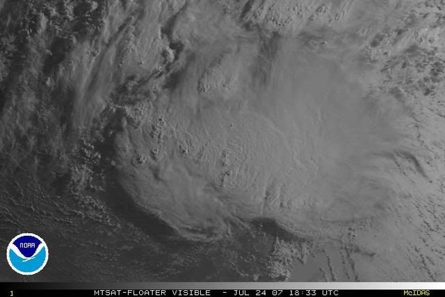
THE REMNANT OF TROPICAL DEPRESSION COSME...LOCATED ABOUT 1400 MILES
WEST-SOUTHWEST OF HONOLULU...IS MOVING WEST NEAR 18 MPH. ALTHOUGH
THUNDERSTORMS ASSOCIATED WITH THIS SYSTEM HAVE INCREASED OVER THE
PAST 6 HOURS...UPPER LEVEL WINDS REMAIN UNFAVORABLE FOR
RE-DEVELOPMENT IN THE CENTRAL NORTH PACIFIC. THE SYSTEM IS EXPECTED
TO CROSS THE INTERNATIONAL DATE LINE...AND OUT OF THE CENTRAL
PACIFIC HURRICANE CENTER/S AREA OF RESPONSIBILITY...WITHIN THE NEXT
6 HOURS.
ELSEWHERE...NO TROPICAL CYCLONES ARE EXPECTED THROUGH EARLY THURSDAY
MORNING.
$$
BIRCHARD


TWOCP
TROPICAL WEATHER OUTLOOK
NWS CENTRAL PACIFIC HURRICANE CENTER HONOLULU HI
400 AM HST TUE JUL 24 2007
FOR THE CENTRAL NORTH PACIFIC...BETWEEN 140W AND 180
THE REMNANT OF TROPICAL DEPRESSION COSME...LOCATED ABOUT 1400 MILES
WEST-SOUTHWEST OF HONOLULU...IS MOVING WEST NEAR 18 MPH. ALTHOUGH
THUNDERSTORMS ASSOCIATED WITH THIS SYSTEM HAVE INCREASED OVER THE
PAST 6 HOURS...UPPER LEVEL WINDS REMAIN UNFAVORABLE FOR
RE-DEVELOPMENT IN THE CENTRAL NORTH PACIFIC. THE SYSTEM IS EXPECTED
TO CROSS THE INTERNATIONAL DATE LINE...AND OUT OF THE CENTRAL
PACIFIC HURRICANE CENTER/S AREA OF RESPONSIBILITY...WITHIN THE NEXT
6 HOURS.
ELSEWHERE...NO TROPICAL CYCLONES ARE EXPECTED THROUGH EARLY THURSDAY
MORNING.
$$
BIRCHARD
0 likes
Re: TD Six-E=TS Cosme=TD Cosme in EPAC,CPAC
It looks better then it ever has in the Cpac. It's just about to enter the Wpac and maybe something else will happen there.
0 likes


-
P.K.

- Professional-Met
- Posts: 5149
- Joined: Thu Sep 23, 2004 5:57 pm
- Location: Watford, England
- Contact:
Re: CPac/WPac: 06E (ex-Cosme) JTWC: POOR
The 24 and 48 hour forecast charts both have this as a 1008hPa TD.


0 likes
-
HURAKAN
- Professional-Met
- Posts: 46086
- Age: 37
- Joined: Thu May 20, 2004 4:34 pm
- Location: Key West, FL
- Contact:
Luis, that's a very good question. In my years of tracking cyclones there has never a situation like this one. Maybe Pete has the answer. I don't know. Nonetheless, this is the same system of low pressure, and therefore, it's still Cosme. The difference in this case campare to cyclones before that had crossed from basin to basin is that there are no advisories being written on Cosme.
0 likes
Who is online
Users browsing this forum: No registered users and 101 guests