Invest 96L,North Atlantic-Discussions

Moderator: S2k Moderators

Message
Author
User avatar
storms in NC
S2K Supporter
S2K Supporter
Posts: 2338
Joined: Thu Jul 28, 2005 2:58 pm
Location: Wallace,NC 40 miles NE of Wilm
Contact:

Re: Invest 96L,East of Carolinas-Discussions-Analysis & Imagery

#41 Postby storms in NC » Thu Aug 30, 2007 2:19 pm

wxman57 wrote:I'm looking at a water vapor loop and I see quite a bit of wind shear building over 96L this afternoon. It may have missed its chance for development. Might not be much left by tomorrow morning.


Seen that too. Soon we will be down to maybe 2 to watch. I have my doubts about any of them. Have to see if the ridge brakes down. I think that would help.
0 likes   

User avatar
Matt-hurricanewatcher
Category 5
Category 5
Posts: 11649
Age: 38
Joined: Fri Nov 26, 2004 11:09 pm
Location: Portland,OR
Contact:

Re: Invest 96L,East of Carolinas-Discussions-Analysis & Imagery

#42 Postby Matt-hurricanewatcher » Thu Aug 30, 2007 3:43 pm

http://www.ssd.noaa.gov/goes/flt/t2/loop-vis.html

My option is this is a tropical depression if not a weak tropical storm. You can see a well defined LLC that has reformed its convection over the last few hours. This thing looks pretty good.

The question is can it come together in the next 12 hour window, against shear? We will see.
0 likes   

User avatar
Buck
Category 5
Category 5
Posts: 1128
Joined: Fri Sep 10, 2004 12:04 pm
Location: Atlanta, GA

#43 Postby Buck » Thu Aug 30, 2007 4:01 pm

I would guess that this is a TD as well... maybe it will be by 11PM. But you are right, being as weak as it is, can it stay together?
0 likes   

Brent
S2K Supporter
S2K Supporter
Posts: 37092
Age: 35
Joined: Sun May 16, 2004 10:30 pm
Location: Tulsa Oklahoma
Contact:

Re: Invest 96L,East of Carolinas-Discussions-Analysis & Imagery

#44 Postby Brent » Thu Aug 30, 2007 4:29 pm

5:30pm TWO:

A SMALL AREA OF LOW PRESSURE ABOUT 325 MILES EAST OF CAPE HATTERAS
IS MOVING SLOWLY NORTH-NORTHWESTWARD...AND IS EXPECTED TO BEGIN
MOVING NORTHEASTWARD AHEAD OF AN APPROACHING FRONTAL SYSTEM. THE
ASSOCIATED SHOWER ACTIVITY HAS BECOME A LITTLE BETTER ORGANIZED
THIS AFTERNOON...AND THE LOW WILL HAVE A BRIEF OPPORTUNITY
FOR TROPICAL CYCLONE FORMATION BEFORE BECOMING OVERTAKEN BY THE
FRONT IN A COUPLE OF DAYS.
0 likes   

User avatar
HURAKAN
Professional-Met
Professional-Met
Posts: 46086
Age: 37
Joined: Thu May 20, 2004 4:34 pm
Location: Key West, FL
Contact:

#45 Postby HURAKAN » Thu Aug 30, 2007 4:59 pm

I expect 96L to be another Chantal on its intensity and organization.
0 likes   

User avatar
HURAKAN
Professional-Met
Professional-Met
Posts: 46086
Age: 37
Joined: Thu May 20, 2004 4:34 pm
Location: Key West, FL
Contact:

#46 Postby HURAKAN » Thu Aug 30, 2007 6:21 pm

Image
0 likes   

User avatar
Epsilon_Fan
Category 1
Category 1
Posts: 353
Joined: Fri Jan 13, 2006 1:03 pm
Location: Charleston, SC

Re: Invest 96L,East of Carolinas-Discussions-Analysis & Imagery

#47 Postby Epsilon_Fan » Thu Aug 30, 2007 6:25 pm

say goodbye to 96L... it's been stripped and the swirl is accelerating toward the frontal boundary. I wonder if it will impact Cape Cod?
0 likes   

CrazyC83
Professional-Met
Professional-Met
Posts: 33393
Joined: Tue Mar 07, 2006 11:57 pm
Location: Deep South, for the first time!

#48 Postby CrazyC83 » Thu Aug 30, 2007 7:37 pm

Looking at QuikSCAT, there is a circulation: http://manati.orbit.nesdis.noaa.gov/dat ... MBas19.png
0 likes   

Cyclone1
Category 5
Category 5
Posts: 2739
Age: 32
Joined: Tue Jun 12, 2007 12:03 pm
Location: Florida

Re:

#49 Postby Cyclone1 » Thu Aug 30, 2007 7:41 pm

CrazyC83 wrote:Looking at QuikSCAT, there is a circulation: http://manati.orbit.nesdis.noaa.gov/dat ... MBas19.png

Yep, it is a TD by definition (kinda).
0 likes   

User avatar
HURAKAN
Professional-Met
Professional-Met
Posts: 46086
Age: 37
Joined: Thu May 20, 2004 4:34 pm
Location: Key West, FL
Contact:

#50 Postby HURAKAN » Thu Aug 30, 2007 7:44 pm

Image

You can see the circulation partially exposed.
0 likes   

CrazyC83
Professional-Met
Professional-Met
Posts: 33393
Joined: Tue Mar 07, 2006 11:57 pm
Location: Deep South, for the first time!

Re: Re:

#51 Postby CrazyC83 » Thu Aug 30, 2007 7:46 pm

Cyclone1 wrote:
CrazyC83 wrote:Looking at QuikSCAT, there is a circulation: http://manati.orbit.nesdis.noaa.gov/dat ... MBas19.png

Yep, it is a TD by definition (kinda).


Center would be around 35.5°N 70.2°W according to that. Strongest wind in there is about 30 kt.
0 likes   

User avatar
cycloneye
Admin
Admin
Posts: 139064
Age: 67
Joined: Thu Oct 10, 2002 10:54 am
Location: San Juan, Puerto Rico

Re: Invest 96L,East of Carolinas-Discussions-Analysis & Imagery

#52 Postby cycloneye » Thu Aug 30, 2007 7:59 pm

WHXX01 KWBC 310058
CHGHUR
TROPICAL CYCLONE GUIDANCE MESSAGE
NWS TPC/NATIONAL HURRICANE CENTER MIAMI FL
0058 UTC FRI AUG 31 2007

DISCLAIMER...NUMERICAL MODELS ARE SUBJECT TO LARGE ERRORS.
PLEASE REFER TO NHC OFFICIAL FORECASTS FOR TROPICAL CYCLONE
AND SUBTROPICAL CYCLONE INFORMATION.

ATLANTIC OBJECTIVE AIDS FOR

DISTURBANCE INVEST (AL962007) 20070831 0000 UTC

...00 HRS... ...12 HRS... ...24 HRS. .. ...36 HRS...
070831 0000 070831 1200 070901 0000 070901 1200

LAT LON LAT LON LAT LON LAT LON
BAMS 37.2N 70.5W 38.5N 70.9W 39.4N 70.0W 39.4N 67.8W
BAMD 37.2N 70.5W 39.1N 70.0W 41.9N 67.4W 45.3N 62.2W
BAMM 37.2N 70.5W 38.7N 70.7W 40.4N 69.0W 42.1N 64.7W
LBAR 37.2N 70.5W 39.4N 69.7W 42.4N 67.0W 46.5N 61.6W
SHIP 25KTS 30KTS 36KTS 44KTS
DSHP 25KTS 30KTS 36KTS 44KTS

...48 HRS... ...72 HRS... ...96 HRS. .. ..120 HRS...
070902 0000 070903 0000 070904 0000 070905 0000

LAT LON LAT LON LAT LON LAT LON
BAMS 38.5N 64.8W 35.0N 60.5W 33.2N 60.4W 33.8N 60.4W
BAMD 49.2N 56.7W 56.7N 48.2W 60.6N 41.8W 64.9N 26.5W
BAMM 44.0N 59.0W 48.3N 46.2W 54.9N 31.8W 61.3N 14.0W
LBAR 51.0N 52.2W .0N .0W .0N .0W .0N .0W
SHIP 46KTS 41KTS 38KTS 27KTS
DSHP 46KTS 41KTS 38KTS 27KTS

...INITIAL CONDITIONS...
LATCUR = 37.2N LONCUR = 70.5W DIRCUR = 340DEG SPDCUR = 11KT
LATM12 = 35.7N LONM12 = 70.4W DIRM12 = 13DEG SPDM12 = 4KT
LATM24 = 35.3N LONM24 = 70.0W
WNDCUR = 25KT RMAXWD = 60NM WNDM12 = 25KT
CENPRS = 1009MB OUTPRS = 1013MB OUTRAD = 120NM SDEPTH = D
RD34NE = 0NM RD34SE = 0NM RD34SW = 0NM RD34NW = 0NM

0 likes   

Cyclone1
Category 5
Category 5
Posts: 2739
Age: 32
Joined: Tue Jun 12, 2007 12:03 pm
Location: Florida

#53 Postby Cyclone1 » Thu Aug 30, 2007 8:29 pm

TCFA issued.
0 likes   

User avatar
HURAKAN
Professional-Met
Professional-Met
Posts: 46086
Age: 37
Joined: Thu May 20, 2004 4:34 pm
Location: Key West, FL
Contact:

#54 Postby HURAKAN » Thu Aug 30, 2007 8:30 pm

TCFA:

Image

SUBJ/TROPICAL CYCLONE FORMATION ALERT 310130Z AUG 07//
WTNT01 KNGU 310200
RMKS/1. FORMATION OF A TROPICAL CYCLONE IS POSSIBLE WITHIN
100 NM EITHER SIDE OF A LINE FROM 36.0N 70.0W TO 38.5N 65.5W
WITHIN THE NEXT 24 HOURS. AVAILABLE DATA DOES NOT JUSTIFY
ISSUANCE OF NUMBERED TROPICAL CYCLONE WARNINGS AT THIS TIME.
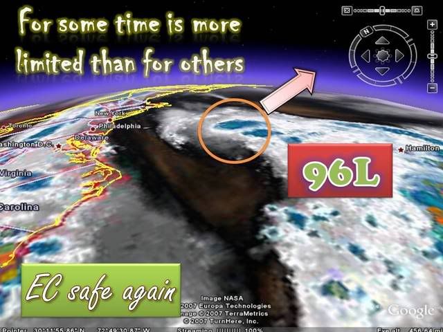
2. A LOW PRESSURE CENTER WAS LOCATED NEAR 36.0N 70.0W WITH AN
ESTIMATED SEA LEVEL PRESSURE OF 1011.0 MB. THIS SYSTEM IS DRIFTING
NORTHEAST AT 5 KNOTS. CURRENT SEA SURFACE TEMPERATURES BELOW AND
NORTHEAST OF THIS LOW PRESSURE SYSTEM ARE CONDUCIVE TO TROPICAL
CYCLONE DEVELOPMENT. ANTI-CYCLONIC FLOW TO THE NORTHEAST OF THIS
SYSTEM ALSO FAVORS TROPICAL CYCLONE DEVELOPMENT. THIS SYSTEM WILL
QUICKLY MOVE NORTHEAST ACROSS THE GULF STREAM AND ENCOUNTER MUCH
COLDER SEA SURFACE TEMPERATURES OVER THE NEXT 36 TO 48 HOURS
WHICH WILL HELP TO INHIBIT ANY FURTHER DEVELOPMENT.
3. THIS ALERT WILL BE REISSUED, UPGRADED TO WARNING OR CANCELLED
BY 010200Z.//
0 likes   

User avatar
wxman57
Moderator-Pro Met
Moderator-Pro Met
Posts: 22480
Age: 66
Joined: Sat Jun 21, 2003 8:06 pm
Location: Houston, TX (southwest)

Re: Invest 96L,-Discussions-TCFA Issued,posted in page 3

#55 Postby wxman57 » Thu Aug 30, 2007 8:38 pm

It's getting ripped apart by shear. Strong southwest winds aloft will only increase with time. There's a weak low-level swirl exposed west of a couple of thunderstorms. That's all we have here. Winds at the surface are in the 10-15 kt around it. Certainly doesn't qualify for a TD. It should start accelerating off to the NNE tonight.

Image
0 likes   

User avatar
HURAKAN
Professional-Met
Professional-Met
Posts: 46086
Age: 37
Joined: Thu May 20, 2004 4:34 pm
Location: Key West, FL
Contact:

#56 Postby HURAKAN » Thu Aug 30, 2007 8:40 pm

Just like Chantal, as it accelerates towards the NE, the shear should be reduced due to the forward speed. This could allow the disturbance to develop in a ~ 24 hrs window for development.
0 likes   

User avatar
wxman57
Moderator-Pro Met
Moderator-Pro Met
Posts: 22480
Age: 66
Joined: Sat Jun 21, 2003 8:06 pm
Location: Houston, TX (southwest)

Re:

#57 Postby wxman57 » Thu Aug 30, 2007 8:44 pm

HURAKAN wrote:Just like Chantal, as it accelerates towards the NE, the shear should be reduced due to the forward speed. This could allow the disturbance to develop in a ~ 24 hrs window for development.


I'd agree with that. Once it does begin accelerating the relative shear may drop enough for convection to fire over the center. But the window of opportunity will be very brief. And the NHC may just let it head out to sea without issuing advisories if it's only going to survive briefly.
0 likes   

CrazyC83
Professional-Met
Professional-Met
Posts: 33393
Joined: Tue Mar 07, 2006 11:57 pm
Location: Deep South, for the first time!

Re: Re:

#58 Postby CrazyC83 » Thu Aug 30, 2007 8:46 pm

wxman57 wrote:
HURAKAN wrote:Just like Chantal, as it accelerates towards the NE, the shear should be reduced due to the forward speed. This could allow the disturbance to develop in a ~ 24 hrs window for development.


I'd agree with that. Once it does begin accelerating the relative shear may drop enough for convection to fire over the center. But the window of opportunity will be very brief. And the NHC may just let it head out to sea without issuing advisories if it's only going to survive briefly.


That's possible. It depends on where it goes. I think it is TD6 now due to the closed circulation on QuikSCAT but I am sure the NHC will hold off on it.
0 likes   

User avatar
wxman57
Moderator-Pro Met
Moderator-Pro Met
Posts: 22480
Age: 66
Joined: Sat Jun 21, 2003 8:06 pm
Location: Houston, TX (southwest)

Re: Re:

#59 Postby wxman57 » Thu Aug 30, 2007 9:04 pm

CrazyC83 wrote:
wxman57 wrote:
HURAKAN wrote:Just like Chantal, as it accelerates towards the NE, the shear should be reduced due to the forward speed. This could allow the disturbance to develop in a ~ 24 hrs window for development.


I'd agree with that. Once it does begin accelerating the relative shear may drop enough for convection to fire over the center. But the window of opportunity will be very brief. And the NHC may just let it head out to sea without issuing advisories if it's only going to survive briefly.


That's possible. It depends on where it goes. I think it is TD6 now due to the closed circulation on QuikSCAT but I am sure the NHC will hold off on it.


Takes more than a closed circulation to be upgraded. The NHC won't upgrade something with an exposed LLC in an increasingly sheared environment.
0 likes   

User avatar
wxman57
Moderator-Pro Met
Moderator-Pro Met
Posts: 22480
Age: 66
Joined: Sat Jun 21, 2003 8:06 pm
Location: Houston, TX (southwest)

Re: Invest 96L,North Atlantic-Discussions-Analysis & Imagery

#60 Postby wxman57 » Thu Aug 30, 2007 9:26 pm

One last shot of 96L before bed. Exposed LLC, moderate SW shear, winds 10-15 kts or less around the low, only one thunderstorm on the NE side of exposed low center. Certainly doesn't qualify for a TD.

Image
0 likes   


Return to “2007”

Who is online

Users browsing this forum: No registered users and 109 guests