We're trying something new here... so please bear with us. This thread is aimed as being an open venue for professional meteorologists to throw their analyses and discussions into, and still be able to interacted with other members to answer questions.
Of course, pros and other approved members are still welcome to post their own threads/forecasts in the Tropical Analysis section while this thread serves as the quick venue for discussion and sharing of thoughts.
Now... with that said... we do have some rules of engagement. Like in the Tropical Analysis section, we ask that this thread be kept clean of random nonsense. Random comments (i.e. one-liners) that aren't asking a met a question will be removed--no warnings. No arguing. It's fine to disagree, but arguing will not be tolerate When someone asks a met a question--let a met answer it. While we appreciate the willingness of those well-versed amateurs (and those who aren't as well-versed), please refrain from answering questions. You can do that in the other threads, but please keep this thread only as a venue for pro mets and their discussions.
Bottom line--let's keep this thread for it's intended purpose.
T S FELIX: *PRO MET* Discussion, Analysis, Questions
Moderator: S2k Moderators
-
oyster_reef

- Tropical Storm

- Posts: 123
- Joined: Tue Aug 14, 2007 3:05 pm
- Location: Alabama
Re: TD SIX: *PRO MET* Discussion, Analysis, Questions
I like it! In regards to forward speed- can we assume the 16mph speed will stay about the same? Is it all about the basic speed of the windlflow around the perimiter of the High that keeps the steady speed? How and why do these systems sometimes stall? Is it possible with TD6?
I know this is a lot of questions. But i'm very curious.
I know this is a lot of questions. But i'm very curious.
0 likes
-
senorpepr

- Military Met/Moderator

- Posts: 12542
- Age: 41
- Joined: Fri Aug 22, 2003 9:22 pm
- Location: Mackenbach, Germany
- Contact:
Re: TD SIX: *PRO MET* Discussion, Analysis, Questions
oyster_reef wrote:In regards to forward speed- can we assume the 16mph speed will stay about the same?
From what I've seen (which isn't much since I just woke up from working an overnight shift
Essentially. If the high doesn't change in intensity or in position, there's really nothing (other than land) that'll change the forward speed.oyster_reef wrote:Is it all about the basic speed of the windlflow around the perimiter of the High that keeps the steady speed?
Either a lack of steering flow (i.e. a tropical depression close to a weak ridge axis) or a blocking high is in the way where the system can't move around it. The chances for 06L to stall... I would say pretty low unless the synoptic pattern changes significantly.oyster_reef wrote:How and why do these systems sometimes stall? Is it possible with TD6?
0 likes
-
Derek Ortt
-
StormSkeptic
- Tropical Low

- Posts: 34
- Joined: Tue Sep 30, 2003 8:40 pm
- Location: New Jersey
I have a couple of questions about the intensification process for developing systems like this (also would apply to strong waves.) At this stage is the intensification process a bit random or soley dictated by the environmental conditions. In other words, does any increase in organaization and intensity depend on how the convection interacts in such a way as to increase organization and lower the pressure as essentially a random process whose likelihood increases with favorable conditions or do favorble conditions inevitably lead to intensification?
Also, does the lowering of the pressure depend on the convection occuring close to the center - thus increasing the core temperature compared to the surroundings, lowering the pressure and causing more inflow - and thus more convection in a positive feedback process or do the curved bands act to concentrate the lowering pressure. A bit of a chicken and egg questions - does the lower pressure cause more organization or more organization cause the lower presurre?
Also, does the lowering of the pressure depend on the convection occuring close to the center - thus increasing the core temperature compared to the surroundings, lowering the pressure and causing more inflow - and thus more convection in a positive feedback process or do the curved bands act to concentrate the lowering pressure. A bit of a chicken and egg questions - does the lower pressure cause more organization or more organization cause the lower presurre?
0 likes
-
Wthrman13

- Professional-Met

- Posts: 502
- Joined: Sun Jul 06, 2003 12:44 pm
- Location: West Lafayette, IN
- Contact:
Re:
StormSkeptic wrote:I have a couple of questions about the intensification process for developing systems like this (also would apply to strong waves.) At this stage is the intensification process a bit random or soley dictated by the environmental conditions. In other words, does any increase in organaization and intensity depend on how the convection interacts in such a way as to increase organization and lower the pressure as essentially a random process whose likelihood increases with favorable conditions or do favorble conditions inevitably lead to intensification?
Also, does the lowering of the pressure depend on the convection occuring close to the center - thus increasing the core temperature compared to the surroundings, lowering the pressure and causing more inflow - and thus more convection in a positive feedback process or do the curved bands act to concentrate the lowering pressure. A bit of a chicken and egg questions - does the lower pressure cause more organization or more organization cause the lower presurre?
Excellent questions. To answer your first one, yes there is a certain amount of randomness involved in regards to the early stages of organization of the convection, but I would think that, given favorable conditions and enough time, this would even itself out over time and, like you said, inevitably lead to intensification. In other words, the effect of an initially "unfavorable" distribution of convection should lessen over time as the storm organizes.
To answer your second question, yes, the initial lowering of surface pressure in a developing TC comes as a result of latent heating due to deep convection near the center. The heating warms the atmospheric column near the center and creates a "bubble" of high pressure, relative to the surroundings, aloft. This sets up an outward directed horizontal pressure gradient over the developing storm, which leads to anticyclonic diverging winds aloft (essentially the TC outflow). Due to the mass being evacuated outward from the center of the TC aloft, this leads to a drop in surface pressure (hydrostatically) and low-level convergence. As this process continues, the low-level winds begin to agitate the sea surface so that there is a positive feedback (stronger surface winds mean a rougher sea surface which means an increase in surface area to transfer moisture and heat to the low-levels). Thus, convection is maintained and increased near the center and the continued latent heating in the updrafts maintains and intensifies the surface low-pressure.
Once a TC gets an eye, some really interesting things can happen. As the eye clears out, a downdraft forms in mid-levels inside the eye. This downdraft is dynamically forced, due to mass conservation, from the surrounding ring of updraft in the eyewall (i.e., some of the air blowing out of the top of the eyewall convection gets recirculated back downward into the eye). Interestingly, this subsidence of air in the eye leads to a great deal of warming due to the compression of the air as it sinks. This warming of the eye can serve to drop the surface pressure very quickly (by 20-30 mb or so, or even more) because the overall column of air in the eye loses mass since warmer air is less dense than cooler air, and mass conservation dictates that air is moved out of the eye at low levels into the eyewall, where it recirculates in the eyewall convective updrafts.
Thus, if you think about all the mass transfers in the system, and how that relates hydrostatically to the surface pressure, you can physically understand a great deal about how a warm-core low-pressure system like a hurricane maintains itself.
EDIT: Sorry forgot about your "chicken-and-egg" question. The answer is both. The low pressure in the center maintains the organization, while the organized inflow is responsible for the sea-to-air transfer of moisture and heat and thus maintains and/or intensifies the low pressure. Typically, however, you need a pre-existing low and associated circulation (such as could come from a tropical wave) to "start the engine".
0 likes
-
philnyc
- S2K Supporter

- Posts: 313
- Joined: Thu Jun 07, 2007 1:14 am
- Location: Brooklyn, New York City, New York
- Contact:
Re: Re:
It appears that Felix will pass over an area of quite high heat potential as it moves south of Haiti:
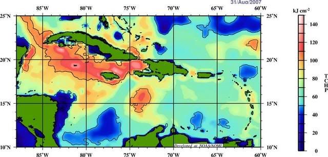
So I have a couple of questions about Tropical Cyclone Heat Potential:
1. At what point of intensity, roughly, do most tropical cyclones begin responding to these high heat potential areas as they pass over them? I understand that it doesn’t make much difference when it’s a depression or storm, but are there any studies yet or generally accepted thresholds at which they really start to intensify noticeably due to the deep heat content? Does it matter with a cat 1 or cat 2?
2. After a cat 3 or higher storm has passed over a particular area, have studies been done, and/or is there a generally accepted rule, as to how long the heat-depleted areas take to recover? Obviously more heat is drawn out by a cat 5 than a cat 4, etc.
3. Do any of the current models that handle intensity use the TCHP in their calculations?
Thanks,
Phil
0 likes
-
Derek Ortt
Re: Hurricane FELIX: *PRO MET* Discussion, Analysis, Questions
Any interests in Honduras
Please take this seriously. Arrival would be in 72 hours. Even a track just north of the coast, like the NHC track has would be devastating. Remember, Fifi never made landfall.
Please take this seriously. Arrival would be in 72 hours. Even a track just north of the coast, like the NHC track has would be devastating. Remember, Fifi never made landfall.
0 likes
-
philnyc
- S2K Supporter
- Posts: 313
- Joined: Thu Jun 07, 2007 1:14 am
- Location: Brooklyn, New York City, New York
- Contact:
Re: Re:
philnyc wrote:It appears that Felix will pass over an area of quite high heat potential as it moves south of Haiti:
So I have a couple of questions about Tropical Cyclone Heat Potential:
1. At what point of intensity, roughly, do most tropical cyclones begin responding to these high heat potential areas as they pass over them? I understand that it doesn’t make much difference when it’s a depression or storm, but are there any studies yet or generally accepted thresholds at which they really start to intensify noticeably due to the deep heat content? Does it matter with a cat 1 or cat 2?
2. After a cat 3 or higher storm has passed over a particular area, have studies been done, and/or is there a generally accepted rule, as to how long the heat-depleted areas take to recover? Obviously more heat is drawn out by a cat 5 than a cat 4, etc.
3. Do any of the current models that handle intensity use the TCHP in their calculations?
Thanks,
Phil
Is this the wrong place for this question? I see warnings in here.
0 likes
-
senorpepr
- Military Met/Moderator
- Posts: 12542
- Age: 41
- Joined: Fri Aug 22, 2003 9:22 pm
- Location: Mackenbach, Germany
- Contact:
Re: Re:
philnyc wrote:Is this the wrong place for this question? I see warnings in here.
No, you're in the right place. I was hoping for someone more versed in the subject to tackle it.
0 likes
-
vbhoutex

- Storm2k Executive

- Posts: 28975
- Age: 72
- Joined: Wed Oct 09, 2002 11:31 pm
- Location: Spring Branch area, Houston, TX
- Contact:
Re: Hurricane FELIX: *PRO MET* Discussion, Analysis, Questions
I am watching the discussiions about Felix, here and elsewhere, and continue to see them alluding to the possible weakness which could form over Texas toward day 5 or so. Knowing we are far out to really forecast this I will still ask a couple of questions.
(1) How probable is this weakness to occur?
(2)If the weakness does occur is Felix going to still be too far south to feel the weakness and react to it? What I have been told in the past is that a TC and another "weather pattern" need to be no further than about 8 degrees of seperation for there to be an influence. Is this correct?
0 likes


Something to throw into the mix: When Felix is forecast to be in the GOM, Henriette is forecast to be over the Sea of Cortez/Gulf of California. What influence, if any, will they have on each other's track and/or intensity? Will they even be close enough to each other to influence the other? Thanks.
0 likes

Re: Hurricane FELIX: *PRO MET* Discussion, Analysis, Questions
guess the pro's don't have time for this thread or forgot it is here?
0 likes
-
Derek Ortt
-
Windtalker2

- Tropical Low
- Posts: 48
- Age: 43
- Joined: Tue Jun 19, 2007 6:28 am
- Location: Davie Florida
Re: Hurricane FELIX: *PRO MET* Discussion, Analysis, Questions
There seems to be an ULL off the SE coast of south Florida, a developing system off the GA coast looking to head S/SE and a trough pushing through Texas in 3 days.
1) will the lows prevent the High from expending westward?
2) will the combination of those lows, a breakdown of the ridge and an approaching trough to the west of Felix cause him to turn more NW after day 3?
Thanks in advance..................Jimmy
1) will the lows prevent the High from expending westward?
2) will the combination of those lows, a breakdown of the ridge and an approaching trough to the west of Felix cause him to turn more NW after day 3?
Thanks in advance..................Jimmy
0 likes
-
Windtalker2
- Tropical Low
- Posts: 48
- Age: 43
- Joined: Tue Jun 19, 2007 6:28 am
- Location: Davie Florida
Re:
Derek Ortt wrote:it has been expected to turn more to the north after 3 days all along
An Honduras & Belize hit is not more North to me...I'm talking an area around the Northern tip of the Yucatan and points North of that.
0 likes
-
Rod Hagen
- Tropical Storm
- Posts: 237
- Joined: Fri Sep 23, 2005 6:22 am
- Location: Lives in Melbourne, works in N Queensland
Re: Hurricane FELIX: *PRO MET* Discussion, Analysis, Questions
The Australian coverage of Felix indicates that it has a very intense, but small, wind field - see http://www.theage.com.au/news/world/hur ... 55043.html.
Is it essentially similar to our own "Cyclone Tracy", that took out Darwin in 1974, in this respect?
Cheers
Rod
Is it essentially similar to our own "Cyclone Tracy", that took out Darwin in 1974, in this respect?
Cheers
Rod
0 likes
-
Derek Ortt
-
tolakram
- Admin
- Posts: 19165
- Age: 60
- Joined: Sun Aug 27, 2006 8:23 pm
- Location: Florence, KY (name is Mark)
Re: Hurricane FELIX: *PRO MET* Discussion, Analysis, Questions
Howdy,
can someone explain the increased outflow evident on the latest sat images?
http://www.ssd.noaa.gov/goes/flt/t1/loop-avn.html
If Felix was a thunderstorm I would call those outflow boundaries. Is this an indication of lost strength while the core re-organizes?
--Mark
can someone explain the increased outflow evident on the latest sat images?
http://www.ssd.noaa.gov/goes/flt/t1/loop-avn.html
If Felix was a thunderstorm I would call those outflow boundaries. Is this an indication of lost strength while the core re-organizes?
--Mark
0 likes
Who is online
Users browsing this forum: No registered users and 70 guests