Sorry that I was not clearer on it being my opinion. I usually try to be careful about it. There is nothing that I see, other than T numbers being initiated again, that says that Ingrid has revived itself. The official ATCF database has not listed it since yesterday but may perhaps again at 2PM EDT. NOAA calls things invests sometimes (Invest, without a number) before they actually are, so NOAA makes an independent determination sometimes. (though it is not official yet because it does not publicly appear in the ATCF database)
The NHC has determined the Ingrid is not invest worthy as of 8AM EDT. (since there was no position update in the ATCF database) That may change as of 2PM EDT, the next time a position update would come in.
Ex-Ingrid north of Leewards
Moderator: S2k Moderators
-
Chris_in_Tampa
- Category 5

- Posts: 4963
- Age: 41
- Joined: Thu Jun 21, 2007 11:06 pm
- Location: Tampa, Florida, USA
- Contact:

Re: Ex-Ingrid north of Leewards makes comeback
Chris_in_Tampa wrote:Sorry that I was not clearer on it being my opinion. I usually try to be careful about it. There is nothing that I see, other than T numbers being initiated again, that says that Ingrid has revived itself. The official ATCF database has not listed it since yesterday but may perhaps again at 2PM EDT. NOAA calls things invests sometimes (Invest, without a number) before they actually are, so NOAA makes an independent determination sometimes. (though it is not official yet because it does not publicly appear in the ATCF database)
The NHC has determined the Ingrid is not invest worthy as of 8AM EDT. (since there was no position update in the ATCF database) That may change as of 2PM EDT, the next time a position update would come in.
ftp://ftp.tpc.ncep.noaa.gov/atcf/tcweb/ ... 007.invest has been updated every six hours...
0 likes
-
Chris_in_Tampa
- Category 5
- Posts: 4963
- Age: 41
- Joined: Thu Jun 21, 2007 11:06 pm
- Location: Tampa, Florida, USA
- Contact:

-
storms in NC

- S2K Supporter

- Posts: 2338
- Joined: Thu Jul 28, 2005 2:58 pm
- Location: Wallace,NC 40 miles NE of Wilm
- Contact:
Re:
gatorcane wrote:Latest:
Ingrid is *slowly* trying to get better organized. I say that because the low-level spin seems to be ever so slowly getting more-defined The LLC looks to be at:
22N 64W moving WNW at about 6mph.
but notice the convection is still way off to the East and still getting sheared.
You know I said last week I would check back on here Wed on Ingrid. But I lied I peeked a few times. LOL
But it will be very interesting to say .
0 likes
-
CalmBeforeStorm

- Category 2

- Posts: 600
- Age: 70
- Joined: Tue Aug 10, 2004 7:55 pm
- Location: Stuart, Florida
Re: Ex-Ingrid north of Leewards makes comeback
http://moe.met.fsu.edu/cgi-bin/cmctc2.c ... =Animation
~~~~~~~~~~
The 12z CMC takes Ingrid right toward South Florida.
~~~~~~~~~~
The 12z CMC takes Ingrid right toward South Florida.
0 likes
-
gatorcane

- S2K Supporter
- Posts: 23499
- Age: 46
- Joined: Sun Mar 13, 2005 3:54 pm
- Location: Boca Raton, FL
Re: Ex-Ingrid north of Leewards makes comeback
There is a low but upper-level winds are still not favorable according to the NHC. I wouldn't expect any changes to the verbage of the 5:30pm TWO
From the NHC 2:05pm TWO.
THE NEXT WEATHER PRODUCER IS THE REMNANTS OF INGRID...ANALYZED AS A 1012 MB LOW
NEAR 22N64W. UPPER-LEVEL WINDS ARE NOT FAVORABLE FOR
REDEVELOPMENT OF THIS SYSTEM. THIS ALONG WITH AN UPPER LOW NEAR
24N66W ARE PRODUCING DISORGANIZED SCATTERED SHOWERS/ISOLATED
TSTMS FROM 19N-24N BETWEEN 59W-64W.
0 likes

Re: Ex-Ingrid north of Leewards makes comeback
I dont know how accurate shear maps are, but it really looks like Ex-Ingrid will hit an area of 5-10kt shear tomorrow, the lowest in some 5 days.
0 likes
-
cycloneye
- Admin

- Posts: 139168
- Age: 67
- Joined: Thu Oct 10, 2002 10:54 am
- Location: San Juan, Puerto Rico
Re: Ex-Ingrid north of Leewards makes comeback
19/1745 UTC 21.7N 64.4W TOO WEAK INGRID -- Atlantic Ocean
It looks like any comeback has stalled as no T Numbers were given.
It looks like any comeback has stalled as no T Numbers were given.
0 likes
-
MiamiensisWx
Re: Ex-Ingrid north of Leewards makes comeback
Currently, the low-level swirl appears to be near 21.8N and 64.8W. It looks like we are seeing a motion just N of due W. It is roughly ~505 miles from the SE Bahamas.
http://www.ssd.noaa.gov/goes/flt/t2/loop-vis.html
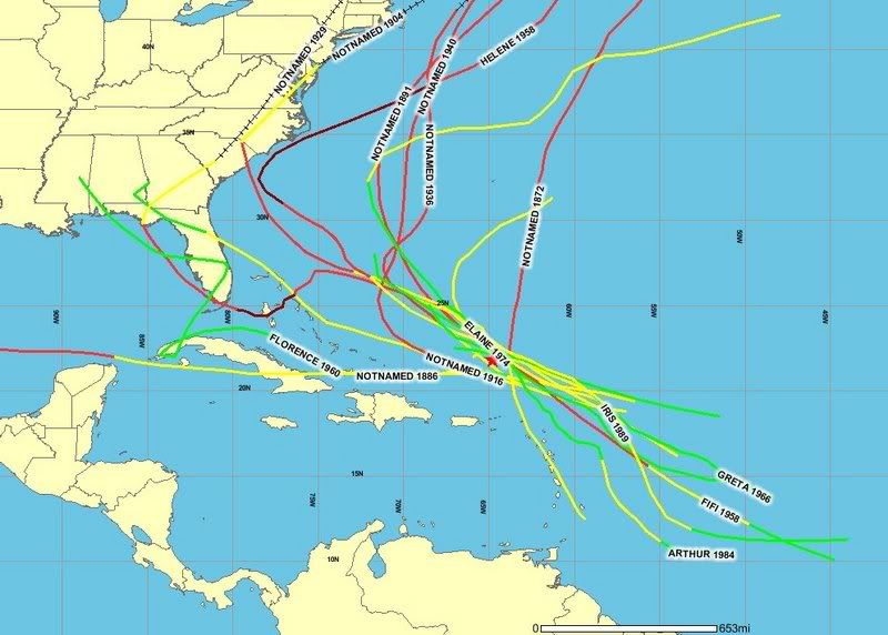
I recently sleuthed some climatological data on all depressions or tropical storms (ex-Ingrid is a shallow system) that passed within ~65 nmi of 24.8N and 64.8W in the month of September. The data encompasses the period from 1851-2006 in the best track database (HURDAT). A total of 14 systems passed within 65 nmi of these coordinates at TD or TS intensity. Eight systems eventually intensified to hurricanes. Only three systems hit Florida: there was one TS, one intense hurricane, and a former TS that moved over SW FL as a TD.
1916 - TS (Cape Canaveral)
1929 - Cat. 3 (upper Florida Keys)
1960 Florence - TD (SW Florida)
One storm (1904) made a direct strike on North Carolina as a hurricane, while another system (Helene '58) brushed the state as an intense hurricane. Additionally, one storm (1886) moved W over Cuba and became a hurricane in the S Gulf of Mexico. All other storms (eight in total) were fish systems. 61 percent never struck the United States. I think ex-Ingrid has poor odds of a United States landfall based on the LLC's latitude, motion, progged pattern, and a dosage of climatology. North Carolina would be the most probable location for a strike if ex-Helene redevelops (unlikely) over the next several days. I still believe a fish is the most plausible outcome.
14 storms
8 fish systems
4 United States landfalls
2 United States hurricanes
1 intense United States landfall
http://www.ssd.noaa.gov/goes/flt/t2/loop-vis.html
I recently sleuthed some climatological data on all depressions or tropical storms (ex-Ingrid is a shallow system) that passed within ~65 nmi of 24.8N and 64.8W in the month of September. The data encompasses the period from 1851-2006 in the best track database (HURDAT). A total of 14 systems passed within 65 nmi of these coordinates at TD or TS intensity. Eight systems eventually intensified to hurricanes. Only three systems hit Florida: there was one TS, one intense hurricane, and a former TS that moved over SW FL as a TD.
1916 - TS (Cape Canaveral)
1929 - Cat. 3 (upper Florida Keys)
1960 Florence - TD (SW Florida)
One storm (1904) made a direct strike on North Carolina as a hurricane, while another system (Helene '58) brushed the state as an intense hurricane. Additionally, one storm (1886) moved W over Cuba and became a hurricane in the S Gulf of Mexico. All other storms (eight in total) were fish systems. 61 percent never struck the United States. I think ex-Ingrid has poor odds of a United States landfall based on the LLC's latitude, motion, progged pattern, and a dosage of climatology. North Carolina would be the most probable location for a strike if ex-Helene redevelops (unlikely) over the next several days. I still believe a fish is the most plausible outcome.
14 storms
8 fish systems
4 United States landfalls
2 United States hurricanes
1 intense United States landfall
0 likes
-
alienstorm

- Category 1

- Posts: 496
- Joined: Tue Jul 31, 2007 1:29 pm
- Location: Miami Fla western suburb
-
MiamiensisWx
Re: Ex-Ingrid north of Leewards makes comeback
Cyclone1,
Here's the link to the interactive HURDAT track database.
http://maps.csc.noaa.gov/hurricanes/
Here's the link to the interactive HURDAT track database.
http://maps.csc.noaa.gov/hurricanes/
0 likes
Re: Ex-Ingrid north of Leewards makes comeback
MiamiensisWx wrote:Cyclone1,
Here's the link to the interactive HURDAT track database.
http://maps.csc.noaa.gov/hurricanes/
Thanks! I've been looking for that site.
0 likes
-
HURAKAN

- Professional-Met

- Posts: 46086
- Age: 37
- Joined: Thu May 20, 2004 4:34 pm
- Location: Key West, FL
- Contact:
Re: Ex-Ingrid north of Leewards makes comeback
alienstorm wrote:Finish, no maas! Put a fork in it...
Irrevocable
Never-ending
Going on
Resistant
Implacable
Durable
PS. Thesaurus consulted!!!
0 likes
-
CrazyC83
- Professional-Met
- Posts: 33393
- Joined: Tue Mar 07, 2006 11:57 pm
- Location: Deep South, for the first time!
Re: Ex-Ingrid north of Leewards makes comeback
HURAKAN wrote:alienstorm wrote:Finish, no maas! Put a fork in it...
Irrevocable
Never-ending
Going on
Resistant
Implacable
Durable
PS. Thesaurus consulted!!!
It could easily be a week or more before we can lose sight of "Blob Ingrid"...
0 likes
-
MiamiensisWx
Re: Ex-Ingrid north of Leewards makes comeback
Gator wrote:
"Ex-Ingrid north of Leewards makes comeback"


Dinner is served!
"Ex-Ingrid north of Leewards makes comeback"
Dinner is served!
0 likes
-
dolebot_Broward_NW
- Category 2
- Posts: 529
- Joined: Fri Sep 10, 2004 6:38 am
Re: Ex-Ingrid north of Leewards makes comeback
http://www.ssd.noaa.gov/goes/flt/t2/loop-rgb.html
Once again the RGB shows (what I think is) the LLC. Its NW of the convection, getting sheared still, but definitely improved from days ago when she was just a naked swirl. At least she's generating convection. Now lets see what that shear is gonna be in 24 hours.
Once again the RGB shows (what I think is) the LLC. Its NW of the convection, getting sheared still, but definitely improved from days ago when she was just a naked swirl. At least she's generating convection. Now lets see what that shear is gonna be in 24 hours.
0 likes

Re: Ex-Ingrid north of Leewards makes comeback
The last convective burst actually came from the LLC that is still rotating near 22N. That indicates to me that there is still some lower surface pressure near the center. I don't like the ridge setup one bit and the ULL that has been providing shear is filling at an alarming rate.
http://wwwghcc.msfc.nasa.gov/GOES/goeseasthurrwv.html
Notice the remnant of the ULL. Just NW of the convection there is a ring.
http://wwwghcc.msfc.nasa.gov/GOES/goeseasthurrwv.html
Notice the remnant of the ULL. Just NW of the convection there is a ring.
Last edited by Nimbus on Wed Sep 19, 2007 2:13 pm, edited 1 time in total.
0 likes
-
dolebot_Broward_NW
- Category 2
- Posts: 529
- Joined: Fri Sep 10, 2004 6:38 am
Re: Ex-Ingrid north of Leewards makes comeback
the ULL that has been providing shear is filling at an alarming rate.
I never understood where the shear came from that destroyed her. Anyone care to point it out?
0 likes
Who is online
Users browsing this forum: No registered users and 50 guests