
Well. September 2007 beat out September 2005.
September 2005: 5 named storms plus Lee from August.
September 2007: 7 named storms plus Felix from August.
Ex Tropical Depression MELISSA- Discussions & Images
Moderator: S2k Moderators
-
JonathanBelles
- Professional-Met

- Posts: 11430
- Age: 33
- Joined: Sat Dec 24, 2005 9:00 pm
- Location: School: Florida State University (Tallahassee, FL) Home: St. Petersburg, Florida
- Contact:
-
sargeabernathy
- Tropical Low

- Posts: 21
- Joined: Sat Sep 29, 2007 5:24 am
Re: Tropical Storm MELISSA - E Atlantic: Discussions & Images
Aug! Just realized my mistake! Yes, Pablo has been used. As has Sebastien, and Tanya. Rebekah, Van, and Wendy have never been used before. 
0 likes


Re: Tropical Storm MELISSA - E Atlantic: Discussions & Images
I must say I expected the "Melissa" storm to be a pretty nasty one. I don't know, the name just sounds... much meaner than Michelle or Marilyn.
0 likes
-
HurricaneRobert
- Category 3

- Posts: 812
- Joined: Fri May 18, 2007 9:31 pm
Re: Tropical Storm MELISSA - E Atlantic: Discussions & Images
Maybe we'll go through the list this season with a bunch of weak tropical or subtropical storms.
0 likes
-
JonathanBelles
- Professional-Met
- Posts: 11430
- Age: 33
- Joined: Sat Dec 24, 2005 9:00 pm
- Location: School: Florida State University (Tallahassee, FL) Home: St. Petersburg, Florida
- Contact:
-
HURAKAN

- Professional-Met
- Posts: 46086
- Age: 37
- Joined: Thu May 20, 2004 4:34 pm
- Location: Key West, FL
- Contact:
Re: Re:
CrazyC83 wrote:Andrew92 wrote:Actually Sandy, there is still Rebekah, which although not exactly brand-new, was a replacement name for Roxanne.
In any event, wow, after Dean and Felix, the deep tropics have been dead in terms of activity! Ingrid, Karen (although I do think she briefly may have been a hurricane), and now Melissa.
I expect Melissa to be a depression later today or tonight, and dissipate tomorrow. The only threat is some flooding in the Cape Verde Islands.
-Andrew92
Same here. A lot of sighs of relief despite the activity - since we were fortunate Humberto and Lorenzo didn't have the time to develop as they had a clear shot at becoming major.
Anyway, the deep tropical Atlantic is probably dead for the season. However, a west Caribbean/Gulf storm could easily become a major problem. The subtropical Atlantic could also produce something significant down the road as well (even if likely a fish)...
My October prediction is 4/2/1.
I meant replacements from the 2001 season.
0 likes


-
storms in NC

- S2K Supporter

- Posts: 2338
- Joined: Thu Jul 28, 2005 2:58 pm
- Location: Wallace,NC 40 miles NE of Wilm
- Contact:


-
cycloneye

- Admin

- Posts: 139077
- Age: 67
- Joined: Thu Oct 10, 2002 10:54 am
- Location: San Juan, Puerto Rico
Re: Tropical Storm MELISSA: Advisories
221
WTNT44 KNHC 292031
TCDAT4
TROPICAL STORM MELISSA DISCUSSION NUMBER 6
NWS TPC/NATIONAL HURRICANE CENTER MIAMI FL AL142007
500 PM EDT SAT SEP 29 2007
AFTER BEING EXPOSED FOR A FEW HOURS...NEW DEEP CONVECTION HAS
REGENERATED NEAR THE CENTER. SATELLITE INTENSITY ESTIMATES...
PRIMARILY OBJECTIVE T-NUMBERS FROM SAB AS WELL AS THOSE
PROVIDED BY UW-CIMSS INDICATE THAT MELISSA IS STILL A 35-KNOT
TROPICAL STORM. SINCE THE SHEAR IS FORECAST TO BE ABOUT 15 TO 20
KNOTS OVER MELISSA DURING THE NEXT DAY OR SO...THE CYCLONE COULD
KEEP ITS STORM STATUS FOR THAT PERIOD. THEREAFTER...BOTH SHEAR AND
A COOL OCEAN WILL LIKELY TAKE A TOLL ON MELISSA. THE CYCLONE IS
EXPECTED TO BE A REMNANT LOW BY THE END OF THE FORECAST PERIOD IF
NOT EARLIER.
MELISSA APPEARS TO BE MOVING TOWARD THE WEST-NORTHWEST OR 300
DEGREES AT 11 KNOTS AROUND THE PERIPHERY OF A MODEST SUBTROPICAL
RIDGE. THE RIDGE IS FORECAST TO EXPAND A LITTLE AND THIS PATTERN
WILL KEEP THE CYCLONE ON THIS GENERAL TRACK. IN THE LAST
RUN...MODELS KEEP MELISSA A LITTLE LONGER...AND ARE IN GOOD
AGREEMENT MOVING THE CYCLONE WEST-NORTHWESTWARD AROUND THE
PERIPHERY OF THE RIDGE. THE OFFICIAL FORECAST IS IN THE MIDDLE
OT THE GUIDANCE ENVELOPE.
FORECAST POSITIONS AND MAX WINDS
INITIAL 29/2100Z 15.6N 29.5W 35 KT
12HR VT 30/0600Z 16.3N 30.9W 35 KT
24HR VT 30/1800Z 17.0N 33.0W 35 KT
36HR VT 01/0600Z 18.0N 35.0W 35 KT
48HR VT 01/1800Z 19.0N 37.0W 30 KT
72HR VT 02/1800Z 21.5N 41.0W 25 KT...DISSIPATING
96HR VT 03/1800Z 24.0N 44.0W 20 KT...REMNANT LOW
120HR VT 04/1800Z 26.0N 45.0W 20 KT...REMNANT LOW
$$
FORECASTER AVILA
0 likes
-
HURAKAN
- Professional-Met
- Posts: 46086
- Age: 37
- Joined: Thu May 20, 2004 4:34 pm
- Location: Key West, FL
- Contact:
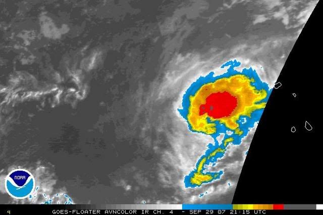
A burst of convection to the east of the center.
Float 2: http://www.ssd.noaa.gov/PS/TROP/float2.html
0 likes
-
Tampa Bay Hurricane

- Category 5

- Posts: 5594
- Age: 36
- Joined: Fri Jul 22, 2005 7:54 pm
- Location: St. Petersburg, FL
Re: TS MELISSA - E Atlantic: Discussions & Images: Floater 2
with that latest burst of convection hurakan has shown
I think that melissa will strengthen some probably
to a strong tropical storm prior to encountering
unfavorable conditions.
I think that melissa will strengthen some probably
to a strong tropical storm prior to encountering
unfavorable conditions.
0 likes

-
Cryomaniac
- Category 5
- Posts: 1289
- Joined: Tue Aug 15, 2006 2:26 pm
- Location: Newark, Nottinghamshire, UK
- Contact:
Re: Tropical Storm MELISSA - E Atlantic: Discussions & Images
HurricaneRobert wrote:Maybe we'll go through the list this season with a bunch of weak tropical or subtropical storms.
Thats my thinking as well, I predicted 19 named at the start of the season, but I think it could be as high as 23.
0 likes

-
Tampa Bay Hurricane
- Category 5
- Posts: 5594
- Age: 36
- Joined: Fri Jul 22, 2005 7:54 pm
- Location: St. Petersburg, FL
Re: TS MELISSA - E Atlantic: Discussions & Images: Floater 2
convective burst may bump this up in strength of that I am
fairly certain in the short term.
fairly certain in the short term.
0 likes
-
AnnularCane

- S2K Supporter
- Posts: 2634
- Joined: Thu Jun 08, 2006 9:18 am
- Location: Wytheville, VA
Re: TS MELISSA - E Atlantic: Discussions & Images: Floater 2
How cute!  Finally, she gets a floater! Looking good right now.
0 likes

Who is online
Users browsing this forum: No registered users and 121 guests