Ex Tropical Depression MELISSA- Discussions & Images
Moderator: S2k Moderators
-
americanrebel

- Category 1

- Posts: 399
- Age: 47
- Joined: Tue Sep 18, 2007 3:42 pm
- Location: Intracoastal City, La.
-
Matt-hurricanewatcher

- Category 5

- Posts: 11649
- Age: 38
- Joined: Fri Nov 26, 2004 11:09 pm
- Location: Portland,OR
- Contact:
Re:
americanrebel wrote:I thought I read 35 KTs, so that would be 40 MPH. I could of read wrong.
The nhc has it as 30 knots.
0 likes


-
Matt-hurricanewatcher
- Category 5
- Posts: 11649
- Age: 38
- Joined: Fri Nov 26, 2004 11:09 pm
- Location: Portland,OR
- Contact:
Re: TD 14: Cape Verde Islands: Discussions & Images
CI# /Pressure/ Vmax
2.5 /1005.0mb/ 35.0kt
Now with higher CI number then Karen.
2.5 /1005.0mb/ 35.0kt
Now with higher CI number then Karen.
0 likes

-
americanrebel
- Category 1
- Posts: 399
- Age: 47
- Joined: Tue Sep 18, 2007 3:42 pm
- Location: Intracoastal City, La.
-
americanrebel
- Category 1
- Posts: 399
- Age: 47
- Joined: Tue Sep 18, 2007 3:42 pm
- Location: Intracoastal City, La.
-
Matt-hurricanewatcher
- Category 5
- Posts: 11649
- Age: 38
- Joined: Fri Nov 26, 2004 11:09 pm
- Location: Portland,OR
- Contact:
Re: TD 14: Cape Verde Islands: Discussions & Images
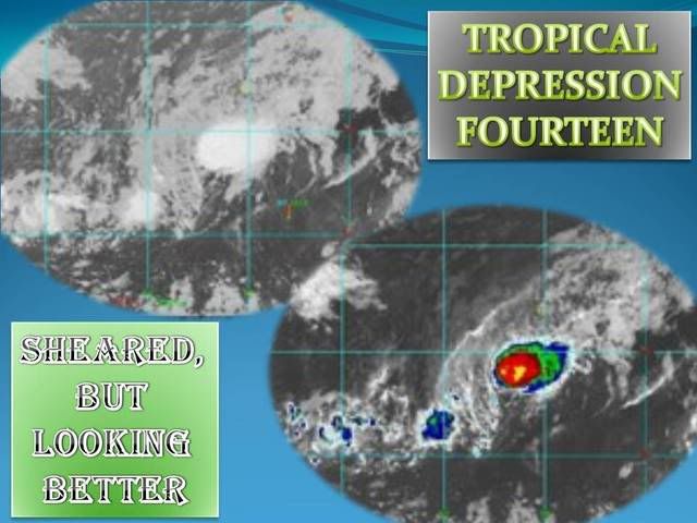
This was very likely a tropical storm this morning. In fact quickscat shown 40-45 knot winds...But that will be post season.
The thing with it now is, it is now more overall organized then karen. It would not suprize me to see t's coming in above 2.5 at 06z this morning.
The thing with it now is, it is now more overall organized then karen. It would not suprize me to see t's coming in above 2.5 at 06z this morning.
0 likes
-
americanrebel
- Category 1
- Posts: 399
- Age: 47
- Joined: Tue Sep 18, 2007 3:42 pm
- Location: Intracoastal City, La.

Re:
0 likes
-
Matt-hurricanewatcher
- Category 5
- Posts: 11649
- Age: 38
- Joined: Fri Nov 26, 2004 11:09 pm
- Location: Portland,OR
- Contact:
Re:
americanrebel wrote:What do these ts mean to overall strength?
"ts"=thunderstorms/convection, I would say it means that the LLC can strengthen. Mostly the LLC is a wind field or heat engine that convergences at the surface and divergents at the upper levels. What shear does is make the stacked system through out the Atmosphere lean over...In which case stops the system from strengthing. The most important thing right now is the LLC is under the convection. That means it can slowly strengthen. I do feel that we have a borderline tropical storm now.
0 likes
-
americanrebel
- Category 1
- Posts: 399
- Age: 47
- Joined: Tue Sep 18, 2007 3:42 pm
- Location: Intracoastal City, La.

Re: TD 14: Cape Verde Islands: Discussions & Images
Matt-hurricanewatcher wrote:This was very likely a tropical storm this morning. In fact quickscat shown 40-45 knot winds...But that will be post season.
It seems like every tropical cyclone this year will need some tweaking for best-track. I agree, TS was there yesturday morning.
0 likes
-
djones65
- Category 1
- Posts: 264
- Age: 58
- Joined: Mon Jun 20, 2005 12:05 am
- Location: Ocean Springs, MS
There was an unidentified ship at 29/0000 UTC near 17N and 26.2W reporting NNE winds (30 degrees) at 33 knots. I don't know if the NHC has done any quality control check or not, but if that was reliable I believe that info would contribute to the evidence that this may be a minimal tropical storm. The ship report also indicated only 3.3 ft wave height which seems low with 33kt winds and pressure was 1014mb.
Go to the National Data Buoy Center website and click on reports near TD #14 and then click on "past 12 hours" and you should find it if you check it prior to 12Z Saturday.
Go to the National Data Buoy Center website and click on reports near TD #14 and then click on "past 12 hours" and you should find it if you check it prior to 12Z Saturday.
0 likes
-
Matt-hurricanewatcher
- Category 5
- Posts: 11649
- Age: 38
- Joined: Fri Nov 26, 2004 11:09 pm
- Location: Portland,OR
- Contact:
Re: TD 14: Cape Verde Islands: Discussions & Images
http://www.eumetsat.int/Home/Main/Image ... x.htm?l=en
600z image is out, and it looks like a tropical storm again. I agree with the 33 knot data...I would not be at all suprized if this was a 35-40 knot tropical storm now.
600z image is out, and it looks like a tropical storm again. I agree with the 33 knot data...I would not be at all suprized if this was a 35-40 knot tropical storm now.
0 likes
-
Matt-hurricanewatcher
- Category 5
- Posts: 11649
- Age: 38
- Joined: Fri Nov 26, 2004 11:09 pm
- Location: Portland,OR
- Contact:
Re: TD 14: Cape Verde Islands: Discussions & Images
Looks like they are not going to take the 33 knot winds into account. Also the deep convection that has formed this morning. GRRR...
0 likes
-
Matt-hurricanewatcher
- Category 5
- Posts: 11649
- Age: 38
- Joined: Fri Nov 26, 2004 11:09 pm
- Location: Portland,OR
- Contact:
Re: TD 14: Cape Verde Islands: Discussions & Images
Oh that 33 knots was from earlier yesterday morning. Also Windsat shown a large area of 35-40 knot winds at about that time. Any way you slice it this season will get a 13th storm.
As of now it is back and looking very good. Also 85h/37v data shows a very defined structure. Maybe the LLC and the precipe is only slightly displaced.
As of now it is back and looking very good. Also 85h/37v data shows a very defined structure. Maybe the LLC and the precipe is only slightly displaced.
0 likes
-
Coredesat
000
WTNT34 KNHC 290841
TCPAT4
BULLETIN
TROPICAL STORM MELISSA ADVISORY NUMBER 4
NWS TPC/NATIONAL HURRICANE CENTER MIAMI FL AL142007
500 AM AST SAT SEP 29 2007
...THIRTEENTH NAMED STORM OF THE SEASON FORMS IN THE FAR EASTERN
ATLANTIC...
AT 500 AM AST...0900Z...THE CENTER OF TROPICAL STORM MELISSA WAS
LOCATED NEAR LATITUDE 14.1 NORTH...LONGITUDE 27.4 WEST OR ABOUT 260
MILES...420 KM...WEST-SOUTHWEST OF THE CAPE VERDE ISLANDS.
MELISSA IS MOVING TOWARD THE WEST NEAR 3 MPH...6 KM/HR. A GRADUAL
TURN TOWARD THE WEST-NORTHWEST WITH AN INCREASE IN FORWARD SPEED IS
EXPECTED DURING THE NEXT 24 HOURS...WHICH WILL TAKE THE DEPRESSION
FARTHER AWAY FROM THE CAPE VERDE ISLANDS.
MAXIMUM SUSTAINED WINDS ARE NEAR 40 MPH...65 KM/HR...WITH HIGHER
GUSTS. SLIGHT STRENGTHENING IS FORECAST DURING THE NEXT 24
HOURS.
TROPICAL STORM FORCE WINDS EXTEND OUTWARD UP TO 70 MILES...110 KM
FROM THE CENTER.
ESTIMATED MINIMUM CENTRAL PRESSURE IS 1005 MB...29.68 INCHES.
REPEATING THE 500 AM AST POSITION...14.1 N...27.4 W. MOVEMENT
TOWARD...WEST NEAR 3 MPH. MAXIMUM SUSTAINED WINDS...40 MPH.
MINIMUM CENTRAL PRESSURE...1005 MB.
THE NEXT ADVISORY WILL BE ISSUED BY THE NATIONAL HURRICANE CENTER AT
1100 AM AST.
$$
FORECASTER KNABB
000
WTNT24 KNHC 290840
TCMAT4
TROPICAL STORM MELISSA FORECAST/ADVISORY NUMBER 4
NWS TPC/NATIONAL HURRICANE CENTER MIAMI FL AL142007
0900 UTC SAT SEP 29 2007
TROPICAL STORM CENTER LOCATED NEAR 14.1N 27.4W AT 29/0900Z
POSITION ACCURATE WITHIN 45 NM
PRESENT MOVEMENT TOWARD THE WEST OR 270 DEGREES AT 3 KT
ESTIMATED MINIMUM CENTRAL PRESSURE 1005 MB
MAX SUSTAINED WINDS 35 KT WITH GUSTS TO 45 KT.
34 KT....... 60NE 60SE 30SW 60NW.
WINDS AND SEAS VARY GREATLY IN EACH QUADRANT. RADII IN NAUTICAL
MILES ARE THE LARGEST RADII EXPECTED ANYWHERE IN THAT QUADRANT.
REPEAT...CENTER LOCATED NEAR 14.1N 27.4W AT 29/0900Z
AT 29/0600Z CENTER WAS LOCATED NEAR 14.1N 27.3W
FORECAST VALID 29/1800Z 14.4N 28.7W
MAX WIND 35 KT...GUSTS 45 KT.
34 KT... 60NE 30SE 30SW 60NW.
FORECAST VALID 30/0600Z 14.8N 30.5W
MAX WIND 40 KT...GUSTS 50 KT.
34 KT... 60NE 30SE 30SW 60NW.
FORECAST VALID 30/1800Z 15.5N 32.7W
MAX WIND 40 KT...GUSTS 50 KT.
34 KT... 60NE 30SE 30SW 60NW.
FORECAST VALID 01/0600Z 16.2N 34.8W
MAX WIND 35 KT...GUSTS 45 KT.
34 KT... 60NE 30SE 30SW 60NW.
FORECAST VALID 02/0600Z 17.5N 38.5W
MAX WIND 30 KT...GUSTS 40 KT.
EXTENDED OUTLOOK. NOTE...ERRORS FOR TRACK HAVE AVERAGED NEAR 225 NM
ON DAY 4 AND 300 NM ON DAY 5...AND FOR INTENSITY NEAR 20 KT EACH DAY
OUTLOOK VALID 03/0600Z 19.0N 42.0W...DISSIPATING
MAX WIND 25 KT...GUSTS 35 KT.
OUTLOOK VALID 04/0600Z 21.0N 45.0W...REMNANT LOW
MAX WIND 20 KT...GUSTS 25 KT.
REQUEST FOR 3 HOURLY SHIP REPORTS WITHIN 300 MILES OF 14.1N 27.4W
NEXT ADVISORY AT 29/1500Z
$$
FORECASTER KNABB
0 likes

Who is online
Users browsing this forum: No registered users and 110 guests