

So this storm could become Subtropical Storm Pablo. But if it waits until next Tuesday to develop into a subtropical storm, it would then be Subtropical Storm Arthur, the first for 2008.
Actually, I think that the hurricane naming season should start on March 1, as nearly opposite the hurricane peak of September 10 as possible and still stay in months.
INVEST 95L: NE Atlantic : Discussions & Images
Moderator: S2k Moderators
-
cycloneye

- Admin

- Posts: 139008
- Age: 67
- Joined: Thu Oct 10, 2002 10:54 am
- Location: San Juan, Puerto Rico
Re: INVEST 95L=Special Tropical Disturbance Statement
The NRL site is having problems today.
0 likes
Re: INVEST 95L in Northeast Atlantic : Discussions & Images
BTW, we are 53.5 hours away from Jan 1 AST.
0 likes

-
wxman57

- Moderator-Pro Met

- Posts: 22480
- Age: 66
- Joined: Sat Jun 21, 2003 8:06 pm
- Location: Houston, TX (southwest)
Re: INVEST 95L in Northeast Atlantic : Discussions & Images
It should be weakening by the 1st. So if it's going to be called an STS by the NHC it'll be tomorrow or Monday. That would mean "Pablo" not "Arthur".
0 likes


Re: INVEST 95L in Northeast Atlantic : Discussions & Images
Looks like we are seeing another Zeta. I wonder if STS or even TS in December have went undetected before? Also, I wonder if La Nina is playing a role in it? I know 2005 was a weak La Nina to Neutral.
0 likes
-
feederband

- S2K Supporter

- Posts: 3423
- Joined: Wed Oct 01, 2003 6:21 pm
- Location: Lakeland Fl
Re:
funster wrote:Wow. Two late season storms. Can you say global warming? It is horrible what mankind has done to the Planet Earth and its many creatures. Here in the USA we are watching the Southeast turn into a desert because of a lack of storms because of global warming!!!
But on a good note we get to talk about storms in December so its not all bad...I blame the earth for global warming anyway...
0 likes
-
TheEuropean

- Professional-Met

- Posts: 1793
- Age: 58
- Joined: Tue Sep 20, 2005 3:17 pm
- Location: Voerde, Germany
- Contact:
Re:
Hi, please don't bring a single event like a late season storm in connection with global warming.
funster wrote:Wow. Two late season storms. Can you say global warming? It is horrible what mankind has done to the Planet Earth and its many creatures. Here in the USA we are watching the Southeast turn into a desert because of a lack of storms because of global warming!!!
0 likes
Re:
HURAKAN wrote:In 1887 we got the same situation. One storm formed pre-season and two post-season. I think it has more to do with an increase in technology and the active period we're going through. I'm in favor of global warming but I don't blame everything on global warming!!
Don't forget January of 1978 too. 1977 was one of the most inactive years for ATL, WPAC, and EPAC. Also, the 1970s was cooler than normal. I also wonder if December storms are undetected. I remember in another thread about storms that went undetected, notably in 1992 and 1997.
0 likes
-
cycloneye
- Admin
- Posts: 139008
- Age: 67
- Joined: Thu Oct 10, 2002 10:54 am
- Location: San Juan, Puerto Rico
Re: INVEST 95L in Northeast Atlantic : Discussions & Images
From the San Juan P.R. AFD:
000
FXCA62 TJSJ 292027
AFDSJU
AREA FORECAST DISCUSSION
NATIONAL WEATHER SERVICE SAN JUAN PR
427 PM AST SAT DEC 29 2007
.SYNOPSIS...AT UPPER LEVELS...A HIGH PRESSURE RIDGE ANCHORED IN
BRAZIL EXTENDS TO CUBA ACROSS THE CENTRAL CARIBBEAN AND WILL
ROTATE EASTWARD OVER THE LOCAL AREA THROUGH TUESDAY. ON THURSDAY AND
FRIDAY IT WILL CONTINUE PAST THE WINDWARD ISLANDS AND FLATTEN OUT
AHEAD OF AN INCOMING LONG WAVE TROUGH. A JET WILL DEVELOP ON THE
BACK SIDE OF THE RETREATING RIDGE ON WEDNESDAY. THIS JET WILL MOVE
NORTH THROUGH THE CARIBBEAN UNTIL IT IS JUST SOUTH OF PUERTO RICO
ON MONDAY...AFTER WHICH IT WILL BE JOINED BY A BRANCH OF THE SUB
TROPICAL JET ASSOCIATED WITH A SHORT WAVE.
AT MID LEVELS...HIGH PRESSURE OVER THE BAHAMAS WILL MOVE EAST
AHEAD OF AN ADVANCING MID-LATITUDE LONG WAVE TROUGH THAT WILL MOVE
INTO THE WESTERN ATLANTIC ON WEDNESDAY. LOW PRESSURE NEAR 27 NORTH
37 WEST ON SUNDAY WILL DRIFT TO 17 NORTH 46 WEST BEFORE MOVING
EAST AGAIN. HIGH PRESSURE WILL REGAIN IN CONTROL OVER THE
CARIBBEAN ON THURSDAY AND CONTINUE THROUGH SUNDAY. MID LEVELS OF THE
ATMOSPHERE REMAIN MOSTLY DRY UNTIL NEXT SATURDAY.
AT LOWER LEVELS...HIGH PRESSURE DOMINATES THE CENTRAL ATLANTIC AND
MAINTAINS A RIDGE INTO THE WESTERN ATLANTIC THROUGH MONDAY. ON
TUESDAY A STRONG COLD FRONT WILL MOVE INTO THE WESTERN ATLANTIC
AND GRADIENTS WILL RELAX IN THE LOCAL AREA. THE FRONT WILL
APPROACH THE LOCAL AREA ON WEDNESDAY. HIGH PRESSURE WILL BUILD
INTO THE WESTERN ATLANTIC BEHIND THE FRONT ON THURSDAY AND
DOMINATE THE ATLANTIC OCEAN THROUGH THE FOLLOWING MONDAY. A STRONG
LOW IN THE CENTRAL ATLANTIC NEAR 27 NORTH 38 WEST WILL MOVE WEST
SOUTHWEST TOWARD THE AREA. SOME OF ITS ENERGY MAY PASS AS A TROUGH
EARLY ON THURSDAY MORNING.
&&
.DISCUSSION...PATCHES OF MID CLOUDS WITH ISOLATED SHOWER(S) HAVE
BEEN RIDING THE TRADE WINDS THROUGH THE AREA...BUT SHOWERS HAVE
BEEN SPARSE AND BARELY APPEARED OVER SOUTHWEST PUERTO RICO THIS
AFTERNOON. PATCHES OF MOISTURE WILL MOVE THROUGH TONIGHT...BUT
AGAIN SHOWER COVERAGE SHOULD BE LIMITED AND POPS WILL MOSTLY BE
BELOW 50 PERCENT EVEN ON THE NORTHEAST COAST OF THE ISLAND AND IN
THE U.S. VIRGIN ISLANDS. WINDS ARE EXPECTED TO INCREASE AS THE
GRADIENTS TIGHTEN SOMEWHAT SUNDAY...PERHAPS EVEN AS EARLY AS
TONIGHT. BEGINNING MONDAY...AND REALLY NOTICEABLE ON TUESDAY...THE
APPROACHING FRONT AND TROUGH WILL CAUSE GRADIENTS TO RELAX
DRAMATICALLY AND WINDS WILL DECREASE. THE MODELS ARE ADVANCING THE
FRONT A LITTLE FURTHER EACH RUN AND THE LATEST RUN BRINGS IN SOME
OF THE EFFECTS OF HIGHER HUMIDITY INTO THE NORTHWEST CORNER OF OUR
FORECAST AREA ON THURSDAY NIGHT...BUT BY THEN IT IS DIMINISHING IN
STRENGTH AND MAY HAVE LITTLE ACTUAL EFFECT ON PUERTO RICO AND THE
U.S. VIRGIN ISLANDS. IT IS STILL TO FAR OUT TO BE CERTAIN THAT IT
WILL EVEN BE ABLE TO ADVANCE THIS FAR. CURRENT GRIDS REFLECT THAT
IT WILL NOT MOVE PAST HISPANIOLA...AND WILL BEGIN RETREATING IN
PERSISTENT EASTERLY FLOW LATE ON FRIDAY AND SATURDAY. SHOWER
ACTIVITY WILL CONTINUE ON AN INTERMITTENT BASIS THROUGH OUT THE
PERIOD. IT IS NOT YET CLEAR HOW OR IF A DEVELOPING DISTURBANCE IN
THE CENTRAL ATLANTIC WILL AFFECT THE AREA WHEN IT APPROACHES ON
WEDNESDAY AND THURSDAY.
0 likes


-
sargeabernathy
- Tropical Low

- Posts: 21
- Joined: Sat Sep 29, 2007 5:24 am
Re:
HURAKAN wrote:Don't know exactly what the NHC is waiting for.
They may be arguing over some specifics. It's late in the season, and this is probably a surprise to them. They might be debating what to do and taking a bit more extra time to do it.
Either that or there may be a statistic they're waiting to come in. I'm wondering if one of the Pro Mets can help me out here ...
EDIT: Okay.
NRL is FINALLY updated.
Last edited by sargeabernathy on Sat Dec 29, 2007 5:24 pm, edited 1 time in total.
0 likes
-
cycloneye
- Admin
- Posts: 139008
- Age: 67
- Joined: Thu Oct 10, 2002 10:54 am
- Location: San Juan, Puerto Rico
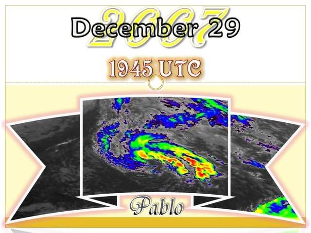
Re: INVEST 95L in Northeast Atlantic : Discussions & Images
0 likes

-
cycloneye
- Admin
- Posts: 139008
- Age: 67
- Joined: Thu Oct 10, 2002 10:54 am
- Location: San Juan, Puerto Rico
Re: INVEST 95L in Northeast Atlantic : Discussions & Images
0 likes
Who is online
Users browsing this forum: No registered users and 20 guests