ATL: DOLLY - REMNANTS - Discussion

Moderator: S2k Moderators

Message
Author
Ntxw
Storm2k Moderator
Storm2k Moderator
Posts: 21501
Joined: Wed Oct 21, 2009 6:34 pm
Location: DFW, Texas

Re: ATL: INVEST 99L - Discussion

#201 Postby Ntxw » Sat Aug 30, 2014 10:23 am

redneckweather wrote:
wxman57 wrote:Would anyone like to guess when was the last time that there was not even a depression in the Gulf prior to September 1st? I'll give you a hint - I was just starting 1st grade.


1961


I double that, 1961 year of Carla
0 likes   
The above post and any post by Ntxw is NOT an official forecast and should not be used as such. It is just the opinion of the poster and may or may not be backed by sound meteorological data. It is NOT endorsed by any professional institution including Storm2k. For official information, please refer to NWS products.

  Help support Storm2K!
Help Support Storm2K

redneckweather
Tropical Wave
Tropical Wave
Posts: 5
Joined: Tue Jan 04, 2011 1:43 pm

Re: ATL: INVEST 99L - Discussion

#202 Postby redneckweather » Sat Aug 30, 2014 10:30 am

Ntxw wrote:
redneckweather wrote:
wxman57 wrote:Would anyone like to guess when was the last time that there was not even a depression in the Gulf prior to September 1st? I'll give you a hint - I was just starting 1st grade.


1961


I double that, 1961 year of Carla


Yea, but I don't think there was a depression in the Gulf prior to Carla.
0 likes   

User avatar
Andrew92
S2K Supporter
S2K Supporter
Posts: 3247
Age: 40
Joined: Mon Jun 16, 2003 12:35 am
Location: Phoenix, Arizona

Re: ATL: INVEST 99L - Discussion

#203 Postby Andrew92 » Sat Aug 30, 2014 10:32 am

wxman57 wrote:Would anyone like to guess when was the last time that there was not even a depression in the Gulf prior to September 1st? I'll give you a hint - I was just starting 1st grade.


1963. Only Gulf storm that year was Cindy which didn't form until September.

-Andrew92
0 likes   

User avatar
Portastorm
Storm2k Moderator
Storm2k Moderator
Posts: 9787
Age: 61
Joined: Fri Jul 11, 2003 9:16 am
Location: South Austin, TX
Contact:

Re: ATL: INVEST 99L - Discussion

#204 Postby Portastorm » Sat Aug 30, 2014 10:57 am

wxman57 wrote:Would anyone like to guess when was the last time that there was not even a depression in the Gulf prior to September 1st? I'll give you a hint - I was just starting 1st grade.


That was late 19th century, right?! :P
0 likes   
Any forecasts under my name are to be taken with a grain of salt. Get your best forecasts from the National Weather Service and National Hurricane Center.

I'm a certified Advanced SKYWARN-trained spotter and am active on Twitter at @TravisCOSW, a social media partner of the NWS Austin-San Antonio office.

YoshiMike
Tropical Storm
Tropical Storm
Posts: 106
Age: 28
Joined: Wed Aug 27, 2014 9:18 pm
Location: Hattiesburg, MS
Contact:

Re: ATL: INVEST 99L - Discussion

#205 Postby YoshiMike » Sat Aug 30, 2014 11:10 am

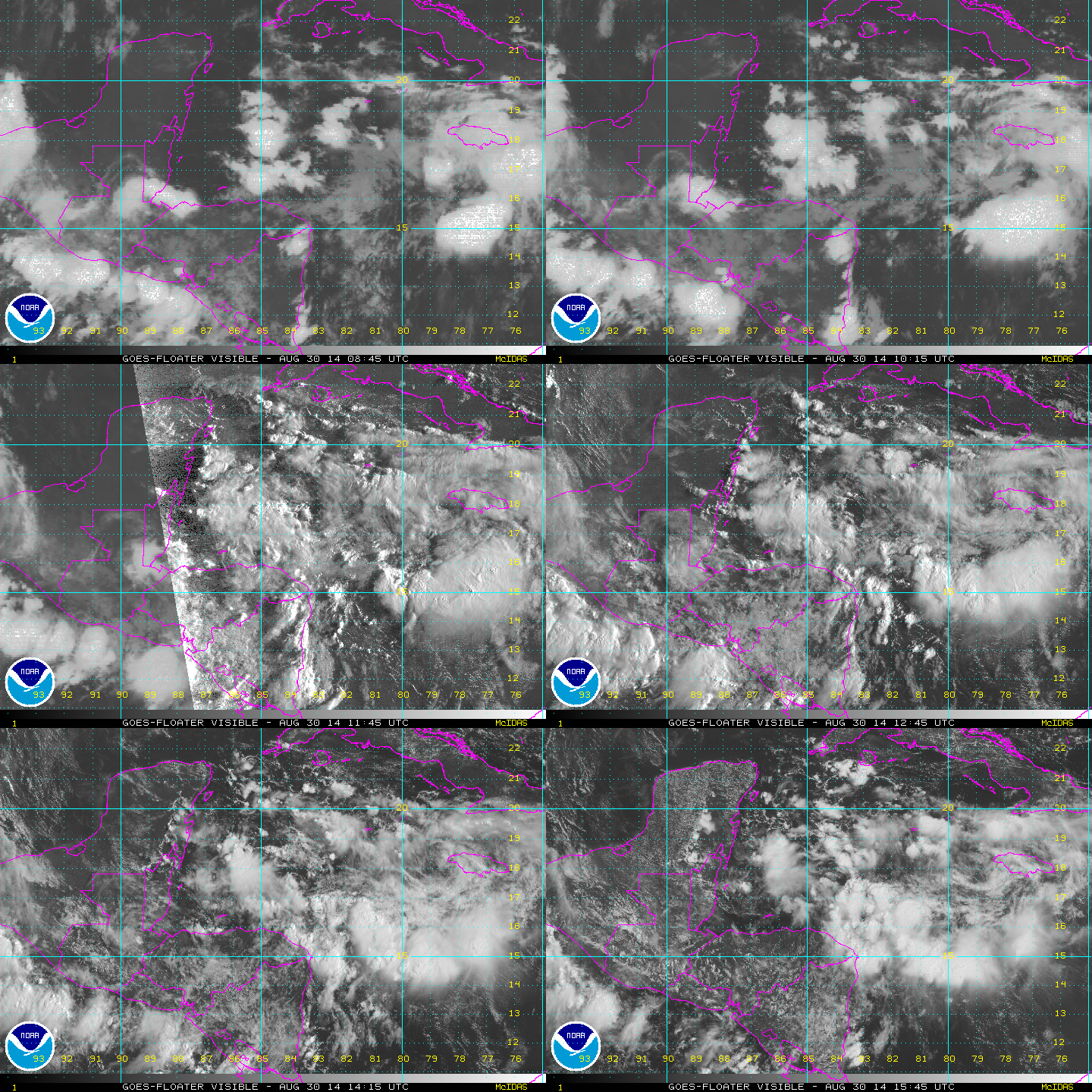
panamatropicwatch wrote:Hard to tell but in the last few images it appears that a circulation might be taking shape in the general vicinity of 17.5n 83.5W.

http://tropicwatch.info/avn_lalo-animated.gif


Yeahm, I can see it! (Hi, I am new!) I'm just hoping it wont affect Hattiesburg. Or if it isn't too it's okay if it does :D LOL
0 likes   
Okay guys, just because I want to BE a meteorologist, want to go to school for meteorology, DOES NOT MAKE ME A METEOROLOGIST. Anything I say about tropical weather is either me learning something new, or is just an opinion and nothing more than that. I can almost guarantee you that I will be wrong about pretty much everything.

User avatar
Rgv20
S2K Supporter
S2K Supporter
Posts: 2456
Age: 37
Joined: Wed Jan 05, 2011 5:42 pm
Location: Edinburg/McAllen Tx

#206 Postby Rgv20 » Sat Aug 30, 2014 11:25 am

99L looks descent on the latest visible satellite..


Saved Loop:
Image
0 likes   
The following post is NOT an official forecast and should not be used as such. It is just the opinion of the poster and may or may not be backed by sound meteorological data. It is NOT endorsed by any professional institution including storm2k.org For Official Information please refer to the NHC and NWS products.

User avatar
tropicwatch
Category 5
Category 5
Posts: 3205
Age: 60
Joined: Sat Jun 02, 2007 10:01 am
Location: Panama City Florida
Contact:

#207 Postby tropicwatch » Sat Aug 30, 2014 11:31 am

Might be getting that look 8-)
0 likes   
Tropicwatch


Agnes 72', Eloise 75, Elena 85', Kate 85', Charley 86', Florence 88', Beryl 94', Dean 95', Erin 95', Opal 95', Earl 98', Georges 98', Ivan 2004', Arlene 2005', Dennis 2005', Ida 2009' Debby 2012' Irma 2017' Michael 2018'

User avatar
Nimbus
Category 5
Category 5
Posts: 4928
Joined: Mon Jul 19, 2004 10:54 am

#208 Postby Nimbus » Sat Aug 30, 2014 11:54 am

The NE pole lost some convection going over Jamaica but should see some rebuilding west of Jamaica around sunset.
0 likes   

User avatar
tropicwatch
Category 5
Category 5
Posts: 3205
Age: 60
Joined: Sat Jun 02, 2007 10:01 am
Location: Panama City Florida
Contact:

#209 Postby tropicwatch » Sat Aug 30, 2014 12:02 pm

:uarrow: I didn't notice that circulation up by Jamaica earlier but 99L at 12z was:

12z Best Track.

99L INVEST 140830 1200 16.6N 84.6W ATL 25 1009

A lot further to the south west of Jamaica.
0 likes   
Tropicwatch


Agnes 72', Eloise 75, Elena 85', Kate 85', Charley 86', Florence 88', Beryl 94', Dean 95', Erin 95', Opal 95', Earl 98', Georges 98', Ivan 2004', Arlene 2005', Dennis 2005', Ida 2009' Debby 2012' Irma 2017' Michael 2018'

Alyono
Professional-Met
Professional-Met
Posts: 6961
Joined: Fri Apr 26, 2013 3:52 pm
Location: Texas Coast

#210 Postby Alyono » Sat Aug 30, 2014 12:11 pm

development chances rapidly decreasing. May not have favorable conditions until this is close to mainland Mexico based upon the latest guidance.
0 likes   

User avatar
tropicwatch
Category 5
Category 5
Posts: 3205
Age: 60
Joined: Sat Jun 02, 2007 10:01 am
Location: Panama City Florida
Contact:

#211 Postby tropicwatch » Sat Aug 30, 2014 12:15 pm

Sliding over parts of Mexico won't help it any either. 8-)
0 likes   
Tropicwatch


Agnes 72', Eloise 75, Elena 85', Kate 85', Charley 86', Florence 88', Beryl 94', Dean 95', Erin 95', Opal 95', Earl 98', Georges 98', Ivan 2004', Arlene 2005', Dennis 2005', Ida 2009' Debby 2012' Irma 2017' Michael 2018'

User avatar
chaser1
S2K Supporter
S2K Supporter
Posts: 4681
Age: 63
Joined: Sat Oct 15, 2005 5:59 pm
Location: Longwood, Fl

Re: ATL: INVEST 99L - Discussion

#212 Postby chaser1 » Sat Aug 30, 2014 12:17 pm

Seems to me to be showing some evidence of maybe a lazy broad cyclonic twist to it. As Alonyo mentioned above, conditions may not be all that favorable still and I just don't think 99L is going to wind up nearly quick enough to pose much issue to points in the Caribbean. On the other hand, flooding rains are always a threat and could simply occur from any significant increase in convection. I just don't see any quick development though
0 likes   
Personal Forecast Disclaimer:
The posts in this forum are NOT official forecast and should not be used as such. They are just the opinion of the poster and may or may not be backed by sound meteorological data. They are NOT endorsed by any professional institution or storm2k.org. For official information, please refer to the NHC and NWS products.


underthwx
Category 5
Category 5
Posts: 1928
Joined: Sat Jul 30, 2011 2:14 pm
Location: Brazoria County Texas

Re: ATL: INVEST 99L - Discussion

#213 Postby underthwx » Sat Aug 30, 2014 12:19 pm

Can anyone post what Mr. Jeff has to offer on 99l? Not sure what website he is on...
0 likes   

User avatar
cycloneye
Admin
Admin
Posts: 139065
Age: 67
Joined: Thu Oct 10, 2002 10:54 am
Location: San Juan, Puerto Rico

Re: ATL: INVEST 99L - Discussion

#214 Postby cycloneye » Sat Aug 30, 2014 12:35 pm

TROPICAL WEATHER OUTLOOK
NWS NATIONAL HURRICANE CENTER MIAMI FL
200 PM EDT SAT AUG 30 2014

For the North Atlantic...Caribbean Sea and the Gulf of Mexico:

Disorganized shower and thunderstorm activity continues in
association with a tropical wave over the northwestern Caribbean
Sea. Upper-level winds are expected to become more conducive during
the next couple of days, but land interaction will likely limit
significant development while the disturbance moves across the
Yucatan peninsula Sunday and Sunday night. Environmental conditions
are expected to be conducive for some gradual development once the
system moves into the southwestern Gulf of Mexico by Monday.
* Formation chance through 48 hours...low...10 percent.
* Formation chance through 5 days...medium...40 percent.

$$
Forecaster Beven
0 likes   
Visit the Caribbean-Central America Weather Thread where you can find at first post web cams,radars
and observations from Caribbean basin members Click Here

underthwx
Category 5
Category 5
Posts: 1928
Joined: Sat Jul 30, 2011 2:14 pm
Location: Brazoria County Texas

Re: ATL: INVEST 99L - Discussion

#215 Postby underthwx » Sat Aug 30, 2014 1:23 pm

Im thinkin 99l will remain basically disorganized due to its interaction with land and at the most.be a depression upon its final destination...only my opinion
0 likes   

User avatar
cycloneye
Admin
Admin
Posts: 139065
Age: 67
Joined: Thu Oct 10, 2002 10:54 am
Location: San Juan, Puerto Rico

Re: ATL: INVEST 99L - Discussion

#216 Postby cycloneye » Sat Aug 30, 2014 1:50 pm

18z Best Track.

99L INVEST 140830 1800 17.1N 85.3W ATL 25 1009
0 likes   
Visit the Caribbean-Central America Weather Thread where you can find at first post web cams,radars
and observations from Caribbean basin members Click Here

User avatar
cycloneye
Admin
Admin
Posts: 139065
Age: 67
Joined: Thu Oct 10, 2002 10:54 am
Location: San Juan, Puerto Rico

Re: ATL: INVEST 99L - Discussion

#217 Postby cycloneye » Sat Aug 30, 2014 6:22 pm

TROPICAL WEATHER OUTLOOK
NWS NATIONAL HURRICANE CENTER MIAMI FL
800 PM EDT SAT AUG 30 2014

For the North Atlantic...Caribbean Sea and the Gulf of Mexico:

Disorganized shower and thunderstorm activity continues in
association with a tropical wave over the northwestern Caribbean
Sea. Land interaction will likely limit significant development
while the disturbance moves across the Yucatan peninsula Sunday and
Sunday night. However, environmental conditions are expected to be
conducive for some gradual development once the system moves into
the southwestern Gulf of Mexico by Monday.
* Formation chance through 48 hours...low...20 percent.
* Formation chance through 5 days...medium...40 percent.

$$
Forecaster Brennan
0 likes   
Visit the Caribbean-Central America Weather Thread where you can find at first post web cams,radars
and observations from Caribbean basin members Click Here

User avatar
TropicalAnalystwx13
Category 5
Category 5
Posts: 2109
Age: 26
Joined: Tue Jul 19, 2011 8:20 pm
Location: Wilmington, NC
Contact:

#218 Postby TropicalAnalystwx13 » Sat Aug 30, 2014 7:05 pm

I'd expect development chances to continue to go up over coming days. Land interaction will slow if not inhibit development tomorrow as the disturbance crosses land. However, after emerging into the Bay of Campeche Monday into Tuesday, wind shear should be light to moderate, sea surface temperatures should be plenty warm, and mid-level moisture should be more than ample to support development. It's also important to keep the curvature of Mexico in mind; when wind flows towards the tall mountains in this region, it's effectively directed in a counter-clockwise fashion, helping to tighten up preexisting circulations, and helping to create new ones.

I have a weak tropical storm moving in near Tampico.
0 likes   

User avatar
wxman57
Moderator-Pro Met
Moderator-Pro Met
Posts: 22480
Age: 66
Joined: Sat Jun 21, 2003 8:06 pm
Location: Houston, TX (southwest)

Re: ATL: INVEST 99L - Discussion

#219 Postby wxman57 » Sat Aug 30, 2014 7:11 pm

Andrew92 wrote:
wxman57 wrote:Would anyone like to guess when was the last time that there was not even a depression in the Gulf prior to September 1st? I'll give you a hint - I was just starting 1st grade.


1963. Only Gulf storm that year was Cindy which didn't form until September.

-Andrew92


Correct! 52 seasons ago. So far this season, we've had only 2 disturbances in the Gulf. That's a record low, too.
0 likes   

User avatar
cycloneye
Admin
Admin
Posts: 139065
Age: 67
Joined: Thu Oct 10, 2002 10:54 am
Location: San Juan, Puerto Rico

Re: ATL: INVEST 99L - Discussion

#220 Postby cycloneye » Sat Aug 30, 2014 7:32 pm

00z Best Track.

99L INVEST 140831 0000 17.7N 86.4W ATL 25 1009
0 likes   
Visit the Caribbean-Central America Weather Thread where you can find at first post web cams,radars
and observations from Caribbean basin members Click Here


Return to “2014”

Who is online

Users browsing this forum: No registered users and 139 guests