ATL: Ex NINE

Moderator: S2k Moderators

Message
Author
ozonepete
Professional-Met
Professional-Met
Posts: 4743
Joined: Mon Sep 07, 2009 3:23 pm
Location: From Ozone Park, NYC / Now in Brooklyn, NY

Re: ATL: INVEST 93L - Discussion

#301 Postby ozonepete » Tue Oct 21, 2014 9:36 pm

NDG wrote:
TheStormExpert wrote:So how is a front even going to be able to make it all the way into the NW Caribbean? With the NAO/AO already Neutral and heading Positive. Plus the PNA heading Negative. Very unfavorable for troughiness in the Eastern U.S., ridging seems more likely.


There is currently a troughiness pattern across the US east Coast lasting over the next 4-6 days or so, after that is when it looks like the pattern will change back to ridging across the eastern US as the NAO & AO does indeed goes to positive and the PNA to negative.


NDG has it right. The bottom line or rather the other BIG caution is you can't over-rely on the NAO and AO. They are way over-rated for telling you how strong ridging or troughing will be in the East or the Atlantic. They are just one tool to use. I always look to see what the experts at NCEP/WPC say when I want to know how the surface will play out, regardless of how sure I am of the upper level forecast. I'm sure you use this, but just in case you don't, I look at this every single day, always:
http://www.hpc.ncep.noaa.gov/basicwx/day0-7loop.html
0 likes   

User avatar
NDG
S2K Supporter
S2K Supporter
Posts: 14933
Joined: Sun Jul 09, 2006 10:14 pm
Location: Orlando, FL

#302 Postby NDG » Tue Oct 21, 2014 9:38 pm

Here is another IR sat loop zoomed into the area of 93L

http://wwwghcc.msfc.nasa.gov/cgi-bin/ge ... mframes=20
0 likes   

User avatar
gatorcane
S2K Supporter
S2K Supporter
Posts: 23499
Age: 46
Joined: Sun Mar 13, 2005 3:54 pm
Location: Boca Raton, FL

Re:

#303 Postby gatorcane » Tue Oct 21, 2014 9:43 pm

northjaxpro wrote:I wished we had Recon misson currently in the system. The convective burst taking place this evening I think should bump this to TD or possibly TS Hanna very shortly.


Agreed I wonder if the pressure has dropped below 1000MB, we may be in the high 990s right now, like around 998MB or 999MB?
0 likes   

blazess556
Professional-Met
Professional-Met
Posts: 250
Joined: Mon Aug 31, 2009 10:51 pm
Location: Germantown, MD

Re: ATL: INVEST 93L - Discussion

#304 Postby blazess556 » Tue Oct 21, 2014 9:46 pm

93L is still fighting 20-25 knots of westerly shear. Convection that is firing this evening is being pushed east of the center. Shear should finally drop below 15 knots in ~24 hours.
0 likes   

ozonepete
Professional-Met
Professional-Met
Posts: 4743
Joined: Mon Sep 07, 2009 3:23 pm
Location: From Ozone Park, NYC / Now in Brooklyn, NY

Re: Re:

#305 Postby ozonepete » Tue Oct 21, 2014 9:47 pm

gatorcane wrote:
northjaxpro wrote:I wished we had Recon misson currently in the system. The convective burst taking place this evening I think should bump this to TD or possibly TS Hanna very shortly.


Agreed I wonder if the pressure has dropped below 1000MB, we may be in the high 990s right now, like around 998MB or 999MB?


Yeah, me too. Pretty likely it has. You can see on the satellite loop that the well-defined LLC got sucked northeastwaard in under the convective blow-up. So it could be consolidating very quickly. But of course this is one of the most famous areas for fast TC development in all of the Atlantic basin.
0 likes   

User avatar
NDG
S2K Supporter
S2K Supporter
Posts: 14933
Joined: Sun Jul 09, 2006 10:14 pm
Location: Orlando, FL

#306 Postby NDG » Tue Oct 21, 2014 9:54 pm

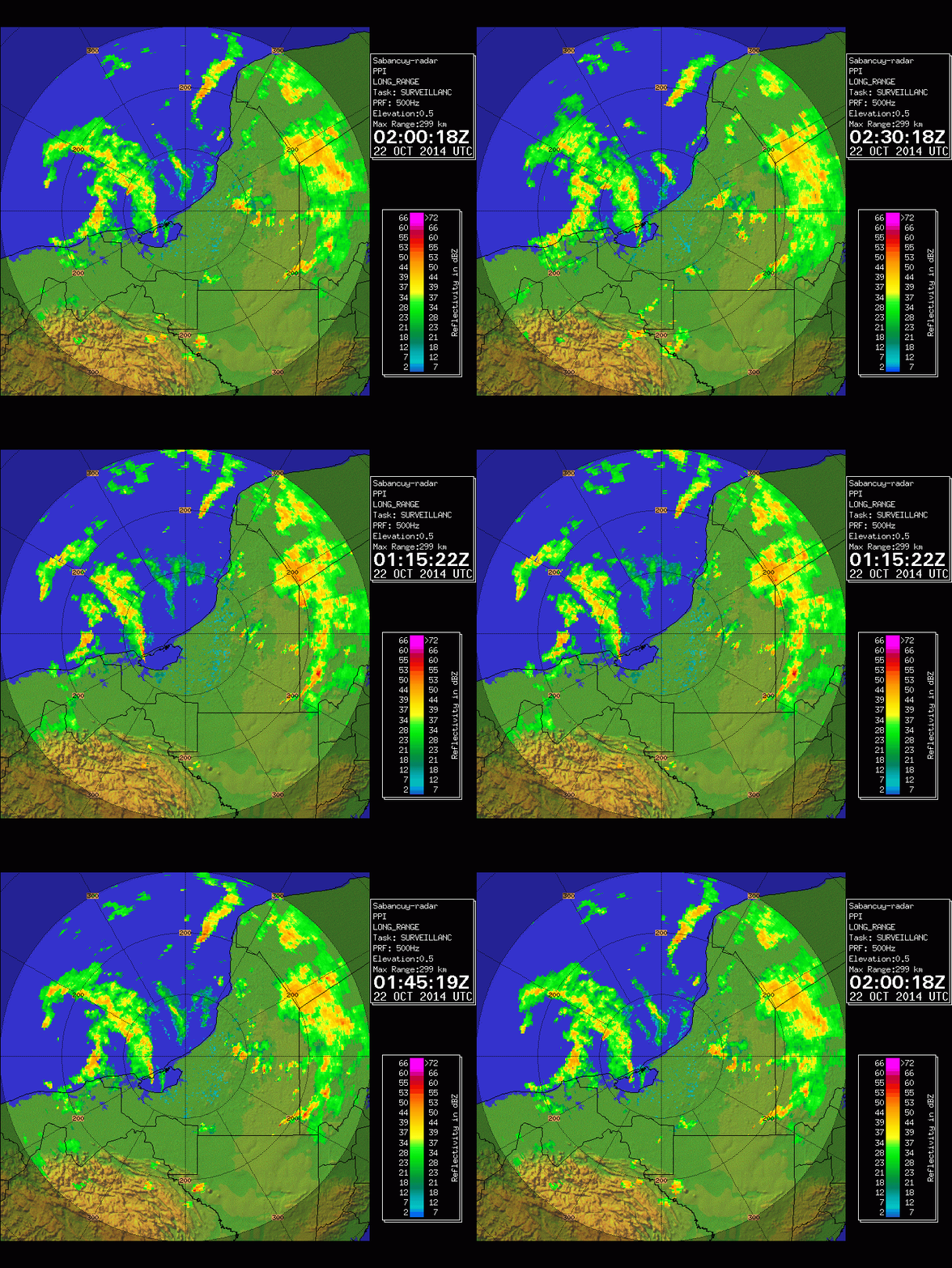
Image
0 likes   

User avatar
NDG
S2K Supporter
S2K Supporter
Posts: 14933
Joined: Sun Jul 09, 2006 10:14 pm
Location: Orlando, FL

#307 Postby NDG » Tue Oct 21, 2014 9:55 pm

This is now TD 9

TROPICAL DEPRESSION NINE FORECAST/ADVISORY NUMBER 1
NWS NATIONAL HURRICANE CENTER MIAMI FL AL092014
0300 UTC WED OCT 22 2014

CHANGES IN WATCHES AND WARNINGS WITH THIS ADVISORY...

THE GOVERNMENT OF MEXICO HAS ISSUED A TROPICAL STORM WARNING FROM
CELESTUN TO FRONTERA.

SUMMARY OF WATCHES AND WARNINGS IN EFFECT...

A TROPICAL STORM WARNING IS IN EFFECT FOR...
* CELESTUN TO FRONTERA

A TROPICAL STORM WARNING MEANS THAT TROPICAL STORM CONDITIONS ARE
EXPECTED SOMEWHERE WITHIN THE WARNING AREA...IN THIS CASE WITHIN
THE NEXT 24 TO 36 HOURS.

TROPICAL DEPRESSION CENTER LOCATED NEAR 19.4N 92.9W AT 22/0300Z
POSITION ACCURATE WITHIN 20 NM

PRESENT MOVEMENT TOWARD THE EAST OR 90 DEGREES AT 5 KT

ESTIMATED MINIMUM CENTRAL PRESSURE 1000 MB
MAX SUSTAINED WINDS 30 KT WITH GUSTS TO 40 KT.
WINDS AND SEAS VARY GREATLY IN EACH QUADRANT. RADII IN NAUTICAL
MILES ARE THE LARGEST RADII EXPECTED ANYWHERE IN THAT QUADRANT.

REPEAT...CENTER LOCATED NEAR 19.4N 92.9W AT 22/0300Z
AT 22/0000Z CENTER WAS LOCATED NEAR 19.4N 93.2W

FORECAST VALID 22/1200Z 19.4N 92.1W
MAX WIND 40 KT...GUSTS 50 KT.
34 KT... 30NE 30SE 20SW 20NW.

FORECAST VALID 23/0000Z 19.4N 91.0W
MAX WIND 45 KT...GUSTS 55 KT.
34 KT... 40NE 40SE 30SW 30NW.

FORECAST VALID 23/1200Z 19.4N 90.0W
MAX WIND 35 KT...GUSTS 45 KT.
34 KT... 30NE 30SE 0SW 20NW.

FORECAST VALID 24/0000Z 19.4N 88.9W
MAX WIND 30 KT...GUSTS 40 KT.

FORECAST VALID 25/0000Z 19.0N 86.6W
MAX WIND 30 KT...GUSTS 40 KT.

EXTENDED OUTLOOK. NOTE...ERRORS FOR TRACK HAVE AVERAGED NEAR 150 NM
ON DAY 4 AND 200 NM ON DAY 5...AND FOR INTENSITY NEAR 15 KT EACH DAY

OUTLOOK VALID 26/0000Z 18.5N 84.5W...POST-TROP/REMNT LOW
MAX WIND 30 KT...GUSTS 40 KT.

OUTLOOK VALID 27/0000Z 18.5N 83.0W...POST-TROP/REMNT LOW
MAX WIND 30 KT...GUSTS 40 KT.

REQUEST FOR 3 HOURLY SHIP REPORTS WITHIN 300 MILES OF 19.4N 92.9W

NEXT ADVISORY AT 22/0900Z

$$
FORECASTER BROWN
0 likes   

User avatar
gatorcane
S2K Supporter
S2K Supporter
Posts: 23499
Age: 46
Joined: Sun Mar 13, 2005 3:54 pm
Location: Boca Raton, FL

#308 Postby gatorcane » Tue Oct 21, 2014 9:58 pm

Can't wait to read the discussion as it is a complex situation that is unfolding the next several days.
Last edited by gatorcane on Tue Oct 21, 2014 9:59 pm, edited 2 times in total.
0 likes   

User avatar
Blown Away
S2K Supporter
S2K Supporter
Posts: 9861
Joined: Wed May 26, 2004 6:17 am

Re: ATL: INVEST 93L - Discussion

#309 Postby Blown Away » Tue Oct 21, 2014 9:58 pm

NHC hugging TVCN model consensus has consistently moved 93L across the Yucatan into the NW Caribbean... It seems the chances 93L will get left behind after the front moves out are increasing and I guess the question is if the conditions will allow 93L to develop... IMO if 93L maintains a tight LLC in the NW Caribbean I bet there will be enough energy to get a decent TS...
Last edited by Blown Away on Tue Oct 21, 2014 10:00 pm, edited 1 time in total.
0 likes   
Hurricane Eye Experience: David 79, Irene 99, Frances 04, Jeanne 04, Wilma 05...
Hurricane Brush Experience: Andrew 92, Erin 95, Floyd 99, Matthew 16, Irma 17, Ian 22, Nicole 22…

User avatar
cycloneye
Admin
Admin
Posts: 139051
Age: 67
Joined: Thu Oct 10, 2002 10:54 am
Location: San Juan, Puerto Rico

Re: ATL: NINE - Tropical Depression - Discussion

#310 Postby cycloneye » Tue Oct 21, 2014 9:59 pm

Image
0 likes   
Visit the Caribbean-Central America Weather Thread where you can find at first post web cams,radars
and observations from Caribbean basin members Click Here

HurriGuy
S2K Supporter
S2K Supporter
Posts: 734
Joined: Thu Aug 15, 2013 8:43 pm
Location: Prairieville, LA

#311 Postby HurriGuy » Tue Oct 21, 2014 10:00 pm

WOW ….look how wide that cone is. lol
0 likes   
The posts in this forum are NOT official forecast and should not be used as such. They are just the opinion of the poster and may or may not be backed by sound meteorological data. They are NOT endorsed by any professional institution or storm2k.org. For official information, please refer to the NHC and NWS products.

floridasun78
Category 5
Category 5
Posts: 3755
Joined: Sun May 17, 2009 10:16 pm
Location: miami fl

Re: ATL: NINE - Tropical Depression - Discussion

#312 Postby floridasun78 » Tue Oct 21, 2014 10:01 pm

it td 9 wow
0 likes   

User avatar
gatorcane
S2K Supporter
S2K Supporter
Posts: 23499
Age: 46
Joined: Sun Mar 13, 2005 3:54 pm
Location: Boca Raton, FL

#313 Postby gatorcane » Tue Oct 21, 2014 10:01 pm

Image
0 likes   

User avatar
blp
Category 5
Category 5
Posts: 2805
Age: 45
Joined: Thu Sep 09, 2004 7:51 pm
Location: Miami, FL
Contact:

Re: ATL: NINE - Tropical Depression - Discussion

#314 Postby blp » Tue Oct 21, 2014 10:02 pm

cycloneye wrote:[]http://oi60.tinypic.com/hrzu4y.jpg[/img]


No dissipation on that graphic.
0 likes   
The following post is NOT an official forecast and should not be used as such. It is just the opinion of the poster and may or may not be backed by sound meteorological data. It is NOT endorsed by any professional institution including storm2k.org For Official Information please refer to the NHC and NWS products.

RL3AO
Moderator-Pro Met
Moderator-Pro Met
Posts: 16308
Joined: Thu Jun 14, 2007 10:03 pm
Location: NC

Re:

#315 Postby RL3AO » Tue Oct 21, 2014 10:02 pm

HurriGuy wrote:WOW ….look how wide that cone is. lol


Cone is the same for every storm this year. Might be the map projection making it look wider than usual.
0 likes   

User avatar
Miami Storm Tracker
Category 3
Category 3
Posts: 893
Age: 66
Joined: Sun Jun 13, 2010 10:12 pm
Location: Key Largo, Fla.
Contact:

Re: ATL: INVEST 93L - Discussion

#316 Postby Miami Storm Tracker » Tue Oct 21, 2014 10:03 pm

Ivanhater wrote:Looks like this is going to be Hannah indeed.


Long time Ivan where have you been, miss your post on here.
0 likes   

User avatar
gatorcane
S2K Supporter
S2K Supporter
Posts: 23499
Age: 46
Joined: Sun Mar 13, 2005 3:54 pm
Location: Boca Raton, FL

#317 Postby gatorcane » Tue Oct 21, 2014 10:04 pm

Initial NHC discussion is going with the ECMWF (despite the GFS and some previous GEM and NAVGEM runs keeping this it's own entity and intensifying it in the NW Caribbean). Not much discussion of the other models though at all. We will wait for the 00Z guidance.
Last edited by gatorcane on Tue Oct 21, 2014 10:05 pm, edited 3 times in total.
0 likes   

HurriGuy
S2K Supporter
S2K Supporter
Posts: 734
Joined: Thu Aug 15, 2013 8:43 pm
Location: Prairieville, LA

#318 Postby HurriGuy » Tue Oct 21, 2014 10:04 pm

NHC does mention the GFS at very end of discussion of not merging with trough.
0 likes   
The posts in this forum are NOT official forecast and should not be used as such. They are just the opinion of the poster and may or may not be backed by sound meteorological data. They are NOT endorsed by any professional institution or storm2k.org. For official information, please refer to the NHC and NWS products.

User avatar
cycloneye
Admin
Admin
Posts: 139051
Age: 67
Joined: Thu Oct 10, 2002 10:54 am
Location: San Juan, Puerto Rico

Re: ATL: NINE - Tropical Depression - Discussion

#319 Postby cycloneye » Tue Oct 21, 2014 10:04 pm

They don't look bullish in NW Caribbean.

If the small cyclone survives the passage across the Yucatan
Peninsula, drier air and interaction with a frontal system is likely
to prevent strengthening. The NHC forecasts calls for degeneration
to a remnant low in 4 or 5 days, but this could occur much sooner.
0 likes   
Visit the Caribbean-Central America Weather Thread where you can find at first post web cams,radars
and observations from Caribbean basin members Click Here

floridasun78
Category 5
Category 5
Posts: 3755
Joined: Sun May 17, 2009 10:16 pm
Location: miami fl

#320 Postby floridasun78 » Tue Oct 21, 2014 10:05 pm

drier air and interaction with a frontal system is likely
to prevent strengthening. The NHC forecasts calls for degeneration
to a remnant low in 4 or 5 days, but this could occur much sooner.
so done in nw carribbean
0 likes   


Return to “2014”

Who is online

Users browsing this forum: No registered users and 33 guests