

WWPS21 NFFN 260900
Tropical Disturbance Summary For area Equator to 25S, 160E to 120W
ISSUED FROM RSMC NADI Feb 26/0928 UTC 2008 UTC.
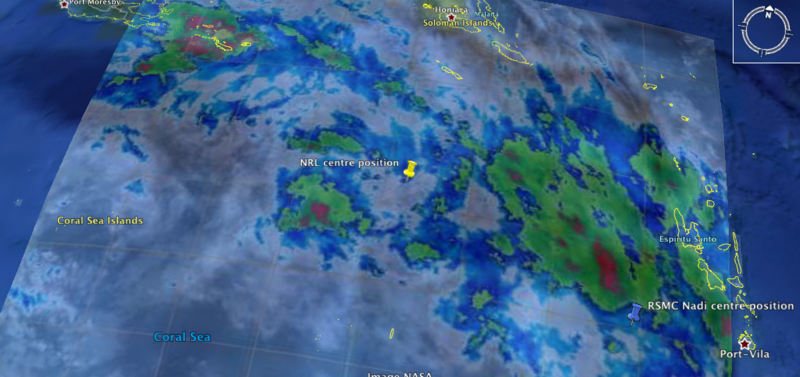
TROPICAL DISTURBANCE TD [1008HPA] NEAR 18.0S 165.5E AT 270600 UTC.
POSITION POOR BASED ON MTSAT IR WITH ANIMATION AND PERPHERIAL SURFACE
OBSERVATION. SST AROUND 29 DEGREE CELCIUS.
CONVECTION REMAINS PERSISTENT FOR THE LAST 24 HOURS AND HAS NOT
DEEPENED MUCH. HOWEVER,ORGANISATION REMAINS POOR WITH CYCLONIC
CIRCULATION FROM SURFACE TO MID LEVEL. TD REMAINS DETACHED TO THE
MOONSONAL TROUGH BUT LIES UNDER A UPPER DIFFLUENT FLOW WITH MINIMAL
SHEAR OVER THE SYSTEM BUT MODERATE SHEAR SOUTH OF TD. GLOBAL MODELS
ARE SLOWLY DEVELOPING THE SYSTEM WITH A SOUTHEAST MOVEMENT. POTENTIAL
FOR THIS SYSTEM TO DEVELOP INTO A TROPICAL CYCLONE IN THE NEXT 24 TO
36 HOURS IS LOW TO MODERATE.
NO OTHER TROPICAL DISTURBANCES ANALYSED OR FORECAST IN THE AREA.
Tropical Disturbance (95P)
Moderator: S2k Moderators
Tropical Disturbance (95P)
0 likes


-
P.K.

- Professional-Met

- Posts: 5149
- Joined: Thu Sep 23, 2004 5:57 pm
- Location: Watford, England
- Contact:
Re: Tropical Disturbance (95P)
Gone.
FQPS01 NFFN 261800
MARINE WEATHER BULLETIN FOR ISLANDS AREA
EQUATOR TO 25S BETWEEN 160E AND 120W.
ISSUED BY FIJI METEOROLOGICAL SERVICE Feb 262000 UTC.
PART 1 : WARNING NIL.
PARTS 2 AND 3 : SYNOPSIS AND FORECAST VALID UNTIL Feb 271800 UTC.
TROUGH T1 17S 160E 21S 167E 18S 175E 16S 180 20S 173W 25S 168W SLOW
MOVING. POOR VISIBILITY IN SCATTERED RAIN AND ISOLATED THUNDERSTORMS
WITHIN 120 MILES OF T1 AND WEST OF 175E. ELSEWHERE,POOR VISIBILITY
IN OCCASIONAL SHOWERS AND ISOLATED THUNDERSTORMS WITHIN 180 MILES OF
T1.
TROUGH T2 09S 177E 13S 174W 20S 167W 25S 165W SLOW MOVING. POOR
VISIBILITY IN SCATTERED SHOWERS AND ISOLATED THUNDERSTORMS WITHIN 120
MILES OF T2.
TROUGH T3 10S 170W 09S 160W 13S 150W 20S 140W 23S 137W SLOW MOVING.
POOR VISIBILITY IN SCATTERED SHOWERS AND ISOLATED THUNDERSTORMS
WITHIN 150 MILES OF T3.
IN THE AREA SOUTH OF 10S AND BETWEEN 140W AND 120W EXPECT MODERATE
SOUTHEAST SWELL.
IN THE AREA SOUTH OF 18S AND WEST OF 175E NORTH TO NORTHWEST WINDS 20
TO 25 KNOTS AND UPTO 30 KNOTS AT TIMES IN THGUNDERSTORM SQUALL.
MODERATE TO ROUGH SEAS.
0 likes

Re: Tropical Disturbance (95P)

IDQ10810
Australian Government Bureau of Meteorology
Queensland
Tropical Cyclone Warning Centre
Media: This message is issued daily for the information of interested parties.
Media are NOT required to broadcast this message.
TROPICAL CYCLONE OUTLOOK
for the Coral Sea West of Longitude 160 East
Issued at 2:30pm on Wednesday the 27th of February 2008
A small low is situated off the North Tropical Coast about 210 km east of
Innisfail. This low will remain near stationary until Thursday morning, when it
should adopt a southeasterly track, parallel to the coast to be about 200 to 300
km off the Central Coast on Friday. Interaction with an approaching upper level
trough may lead to a strengthening of the low as it begins to move to the
southeast, however the system has a low probability of developing into a
tropical cyclone.
A second tropical low situated on the monsoon trough near 17S 160E. This low is
expected to move in a southerly direction to be roughly near 25S 160E by Friday.
This system will gradually intensify as it moves south but is not expected to
develop into a tropical cyclone within the next three days.
Tropical Cyclone outlooks issued by Brisbane can be accessed through the
Bureau's Home Page http://www.bom.gov.au.
Please note that the Darwin Regional Forecasting Centre issues Tropical
Cyclone Outlooks that cover the Gulf of Carpentaria. See
http:/www.bom.gov.au/weather/nt/cyclone/ or to subscribe to this service
call Darwin 08 8920 3820.
0 likes


Who is online
Users browsing this forum: No registered users and 4 guests