

NW Australia: Tropical Cyclone Ophelia
Moderator: S2k Moderators
Re: NW Australia: Tropical Cyclone Ophelia
IDW27300
TROPICAL CYCLONE TECHNICAL SUMMARY: AUSTRALIA - WESTERN REGION
Issued by PERTH TROPICAL CYCLONE WARNING CENTRE
at: 1253 UTC 02/03/2008
Name: Ophelia
Data At: 1200 UTC
Latitude: 16.6S
Longitude: 120.0E
Location Accuracy: within 20 nm (37 km)
Movement Towards: west southwest (253 deg)
Speed of Movement: 7 knots (13 km/h)
Maximum 10-Minute Wind: 55 knots (100 km/h)
Maximum 3-Second Wind Gust: 80 knots (150 km/h)
Central Pressure: 976 hPa
Radius of 34-knot winds NE quadrant: 60 nm (110 km)
Radius of 34-knot winds SE quadrant: 60 nm (110 km)
Radius of 34-knot winds SW quadrant: 60 nm (110 km)
Radius of 34-knot winds NW quadrant: 60 nm (110 km)
Radius of 48-knot winds NE quadrant: 20 nm (37 km)
Radius of 48-knot winds SE quadrant: 20 nm (37 km)
Radius of 48-knot winds SW quadrant: 20 nm (37 km)
Radius of 48-knot winds NW quadrant: 20 nm (37 km)
Radius of 64-knot winds:
Radius of Maximum Winds: 15 nm (28 km)
Dvorak Intensity Code: T4.0/4.0/D1.0/24HRS
Pressure of outermost isobar: 1004 hPa
Radius of outermost closed isobar: 90 nm (165 km)
Storm Depth: Deep
FORECAST DATA
Date/Time : Location : Loc. Accuracy: Max Wind : Central Pressure
(UTC) : degrees : nm (km): knots(km/h): hPa
+12: 03/0000: 17.0S 118.2E: 040 (075): 065 (120): 968
+24: 03/1200: 17.5S 116.5E: 060 (110): 075 (140): 960
+36: 04/0000: 18.0S 114.6E: 080 (150): 080 (150): 956
+48: 04/1200: 18.7S 112.8E: 100 (185): 075 (140): 960
REMARKS:
Tropical Cyclone Ophelia is a small system that is likely to be responsive to its environment and
to diurnal trends. It has struggled to intensify during the unfavourable afternoon period despite
weak vertical shear. The assignment of T4.0 is considered to be at the upper limit with DT
numbers hovering between 3.5 and 4.0. Microwave imagery shows a well developed LLCC with
a partially developed eye wall in deep convection, consistent with this range of intensity. Given
the small size of the inner core AMSU intensity algorithms may underestimate intensity,
particularly if RMW is less than quoted.
Most models forecast shear to remain low over the next 24 hours, but in the following 24 hours
some models indicate upper level westerlies over the system that although only moderate in
strength may be sufficient to limit further intensification. In the longer term the system will
encounter cooler waters after moving west of 110E.
There is little variation in the model guidance tracks in the short term, with all nearly all
guidance indicating a persistent west southwest motion over the next two days under the
influence of a mid-level ridge to the south. After that there is some question as to whether an
approaching mid level trough will sufficiently erode the ridge to encourage a more southerly
track, however most models favour continuation of a westerly track.
Notes:
This product is issued every six hours; the Cyclone Advices (Watches and Warnings) are
usually issued more frequently and contain more useful information for coastal communities.
Time Conversion from UTC to local:
WST add 8 hrs (Add another hour for daylight saving)
CST add 9 hrs 30 min
EST add 10 hrs (Add another hour for daylight saving)
==
The next bulletin for this system will be issued by: 02/1900 UTC by Perth TCWC.
0 likes


-
HURAKAN

- Professional-Met

- Posts: 46086
- Age: 37
- Joined: Thu May 20, 2004 4:34 pm
- Location: Key West, FL
- Contact:
Australian Government Bureau of Meteorology
Western Australia
TROPICAL CYCLONE INFORMATION BULLETIN
Issued at 3:35 am WDT on Monday, 3 March 2008
BY THE BUREAU OF METEOROLOGY
TROPICAL CYCLONE WARNING CENTRE PERTH
At 3 am WDT Tropical Cyclone Ophelia [Category 2] was located near 16.8S 119.2E,
that is 345 km west northwest of Broome, and 395 km north of Port Hedland,
moving west at 13 kilometres per hour.
Tropical Cyclone Ophelia continues to track west southwest off the west
Kimberley coast and does not pose a threat to coastal communities within the
next 48 hours. Ophelia is expected to maintain a west southwesterly track as it
gradually intensifies over the next two days.
The next Information Bulletin will be issued at 10 am WDT.
0 likes

-
HURAKAN
- Professional-Met
- Posts: 46086
- Age: 37
- Joined: Thu May 20, 2004 4:34 pm
- Location: Key West, FL
- Contact:
WTXS31 PGTW 022100
MSGID/GENADMIN/NAVPACMETOCCEN PEARL HARBOR HI//
SUBJ/TROPICAL CYCLONE WARNING//
RMKS/
1. TROPICAL CYCLONE 21S (OPHELIA) WARNING NR 006
01 ACTIVE TROPICAL CYCLONE IN SOUTHIO
MAX SUSTAINED WINDS BASED ON ONE-MINUTE AVERAGE
---
WARNING POSITION:
021800Z --- NEAR 16.9S 119.0E
MOVEMENT PAST SIX HOURS - 250 DEGREES AT 09 KTS
POSITION ACCURATE TO WITHIN 040 NM
POSITION BASED ON CENTER LOCATED BY SATELLITE
PRESENT WIND DISTRIBUTION:
MAX SUSTAINED WINDS - 065 KT, GUSTS 080 KT
WIND RADII VALID OVER OPEN WATER ONLY
RADIUS OF 050 KT WINDS - 030 NM NORTHEAST QUADRANT
035 NM SOUTHEAST QUADRANT
035 NM SOUTHWEST QUADRANT
030 NM NORTHWEST QUADRANT
RADIUS OF 034 KT WINDS - 060 NM NORTHEAST QUADRANT
065 NM SOUTHEAST QUADRANT
065 NM SOUTHWEST QUADRANT
060 NM NORTHWEST QUADRANT
REPEAT POSIT: 16.9S 119.0E
---
FORECASTS:
12 HRS, VALID AT:
030600Z --- 17.4S 117.2E
MAX SUSTAINED WINDS - 070 KT, GUSTS 085 KT
WIND RADII VALID OVER OPEN WATER ONLY
RADIUS OF 064 KT WINDS - 020 NM NORTHEAST QUADRANT
020 NM SOUTHEAST QUADRANT
020 NM SOUTHWEST QUADRANT
020 NM NORTHWEST QUADRANT
RADIUS OF 050 KT WINDS - 035 NM NORTHEAST QUADRANT
040 NM SOUTHEAST QUADRANT
040 NM SOUTHWEST QUADRANT
035 NM NORTHWEST QUADRANT
RADIUS OF 034 KT WINDS - 070 NM NORTHEAST QUADRANT
075 NM SOUTHEAST QUADRANT
075 NM SOUTHWEST QUADRANT
070 NM NORTHWEST QUADRANT
VECTOR TO 24 HR POSIT: 255 DEG/ 09 KTS
---
24 HRS, VALID AT:
031800Z --- 17.9S 115.3E
MAX SUSTAINED WINDS - 080 KT, GUSTS 100 KT
WIND RADII VALID OVER OPEN WATER ONLY
RADIUS OF 064 KT WINDS - 025 NM NORTHEAST QUADRANT
025 NM SOUTHEAST QUADRANT
025 NM SOUTHWEST QUADRANT
025 NM NORTHWEST QUADRANT
RADIUS OF 050 KT WINDS - 040 NM NORTHEAST QUADRANT
045 NM SOUTHEAST QUADRANT
045 NM SOUTHWEST QUADRANT
040 NM NORTHWEST QUADRANT
RADIUS OF 034 KT WINDS - 080 NM NORTHEAST QUADRANT
085 NM SOUTHEAST QUADRANT
085 NM SOUTHWEST QUADRANT
080 NM NORTHWEST QUADRANT
VECTOR TO 36 HR POSIT: 245 DEG/ 09 KTS
---
36 HRS, VALID AT:
040600Z --- 18.7S 113.6E
MAX SUSTAINED WINDS - 085 KT, GUSTS 105 KT
WIND RADII VALID OVER OPEN WATER ONLY
RADIUS OF 064 KT WINDS - 035 NM NORTHEAST QUADRANT
035 NM SOUTHEAST QUADRANT
035 NM SOUTHWEST QUADRANT
035 NM NORTHWEST QUADRANT
RADIUS OF 050 KT WINDS - 045 NM NORTHEAST QUADRANT
055 NM SOUTHEAST QUADRANT
055 NM SOUTHWEST QUADRANT
050 NM NORTHWEST QUADRANT
RADIUS OF 034 KT WINDS - 085 NM NORTHEAST QUADRANT
090 NM SOUTHEAST QUADRANT
090 NM SOUTHWEST QUADRANT
085 NM NORTHWEST QUADRANT
VECTOR TO 48 HR POSIT: 245 DEG/ 09 KTS
---
EXTENDED OUTLOOK:
48 HRS, VALID AT:
041800Z --- 19.4S 111.9E
MAX SUSTAINED WINDS - 080 KT, GUSTS 100 KT
WIND RADII VALID OVER OPEN WATER ONLY
RADIUS OF 064 KT WINDS - 030 NM NORTHEAST QUADRANT
030 NM SOUTHEAST QUADRANT
030 NM SOUTHWEST QUADRANT
030 NM NORTHWEST QUADRANT
RADIUS OF 050 KT WINDS - 040 NM NORTHEAST QUADRANT
050 NM SOUTHEAST QUADRANT
050 NM SOUTHWEST QUADRANT
040 NM NORTHWEST QUADRANT
RADIUS OF 034 KT WINDS - 080 NM NORTHEAST QUADRANT
085 NM SOUTHEAST QUADRANT
085 NM SOUTHWEST QUADRANT
080 NM NORTHWEST QUADRANT
VECTOR TO 72 HR POSIT: 230 DEG/ 09 KTS
---
72 HRS, VALID AT:
051800Z --- 21.7S 108.7E
MAX SUSTAINED WINDS - 075 KT, GUSTS 090 KT
WIND RADII VALID OVER OPEN WATER ONLY
RADIUS OF 064 KT WINDS - 020 NM NORTHEAST QUADRANT
020 NM SOUTHEAST QUADRANT
020 NM SOUTHWEST QUADRANT
020 NM NORTHWEST QUADRANT
RADIUS OF 050 KT WINDS - 035 NM NORTHEAST QUADRANT
040 NM SOUTHEAST QUADRANT
040 NM SOUTHWEST QUADRANT
035 NM NORTHWEST QUADRANT
RADIUS OF 034 KT WINDS - 075 NM NORTHEAST QUADRANT
080 NM SOUTHEAST QUADRANT
080 NM SOUTHWEST QUADRANT
075 NM NORTHWEST QUADRANT
---
REMARKS:
022100Z POSITION NEAR 17.0S 118.5E.
TROPICAL CYCLONE (TC) 21S (OPHELIA) LOCATED APPROXIMATELY 430 NM
NORTHEAST OF LEARMONTH, AUSTRALIA, HAS TRACKED WESTWARD AT 09
KNOTS OVER THE PAST 06 HOURS. TC 21S CONTINUES TO TRACK IN A WEST TO
WEST-SOUTHWESTERLY DIRECTION ALONG THE NORTHERN PERIPHERY OF THE
MID-LEVEL RIDGE TO THE SOUTH OF THE STORM. THIS TRACK IS EXPECTED TO
CONTINUE THROUGH TAU 48. THE STORM WILL THEN BEGIN TO TRACK MORE
SOUTHWESTWARD ALONG THE NORTHWESTERN PERIPHERY OF THE STEERING RIDGE
THROUGH THE REMAINDER OF THE FORECAST PERIOD. TC 21S HAS INTENSIFIED
SLIGHTLY OVER THE PAST 06 HOURS. FAVORABLE ENVIRONMENTAL CONDITIONS
OF LOW VERTICAL WIND SHEAR AND GOOD EQUATORWARD OUTFLOW REMAIN, BUT
DRIER AIR AHEAD OF THE STORM WILL KEEP INTENSIFICATION SLOW THROUGH
TAU 36. AFTER THIS TIME, THE STORM WILL BEGIN TO WEAKEN DUE TO A
DECREASE IN OCEAN HEAT CONTENT AND INCREASE VERTICAL WIND SHEAR. THE
TRACK FORECAST REMAINS CLOSE TO THE CONSENSUS OF THE NUMERICAL AIDS,
WHICH ARE IN GOOD AGREEMENT. MAXIMUM SIGNIFICANT WAVE HEIGHT AT
021800Z IS 19 FEET. NEXT WARNINGS AT 030300Z, 030900Z, 031500Z AND
032100Z.
//
NNNN
0 likes


Re: NW Australia: Tropical Cyclone Ophelia
IDW27300
TROPICAL CYCLONE TECHNICAL SUMMARY: AUSTRALIA - WESTERN REGION
Issued by PERTH TROPICAL CYCLONE WARNING CENTRE
at: 0050 UTC 03/03/2008
Name: Ophelia
Data At: 0000 UTC
Latitude: 16.7S
Longitude: 118.5E
Location Accuracy: within 25 nm (46 km)
Movement Towards: west (266 deg)
Speed of Movement: 7 knots (13 km/h)
Maximum 10-Minute Wind: 55 knots (100 km/h)
Maximum 3-Second Wind Gust: 80 knots (150 km/h)
Central Pressure: 974 hPa
Radius of 34-knot winds NE quadrant: 40 nm (75 km)
Radius of 34-knot winds SE quadrant: 50 nm (95 km)
Radius of 34-knot winds SW quadrant: 60 nm (110 km)
Radius of 34-knot winds NW quadrant: 60 nm (110 km)
Radius of 48-knot winds NE quadrant: 20 nm (37 km)
Radius of 48-knot winds SE quadrant: 20 nm (37 km)
Radius of 48-knot winds SW quadrant: 20 nm (37 km)
Radius of 48-knot winds NW quadrant: 20 nm (37 km)
Radius of 64-knot winds:
Radius of Maximum Winds: 10 nm (19 km)
Dvorak Intensity Code: T3.5/4.0/D0.5/24HRS
Pressure of outermost isobar: 1006 hPa
Radius of outermost closed isobar: 90 nm (165 km)
Storm Depth: Deep
FORECAST DATA
Date/Time : Location : Loc. Accuracy: Max Wind : Central Pressure
(UTC) : degrees : nm (km): knots(km/h): hPa
+12: 03/1200: 16.8S 116.9E: 045 (085): 055 (100): 974
+24: 04/0000: 17.3S 115.0E: 065 (120): 065 (120): 968
+36: 04/1200: 17.8S 113.2E: 085 (155): 060 (110): 972
+48: 05/0000: 18.6S 111.4E: 105 (195): 055 (100): 974
REMARKS:
Ophelia is a small system that has not shown indications of further intensification overnight. Satellite iImagery suggests some influence of N/NE shear maybe a constraint although the system remains near the shear minimum.
Dvorak analysis: FT of 3.5 based on MET with ambiguous curved band pattern for a small
system although a T4.0 is just possible with embedded centre technique. CI held at 4.0.
A return to some intensification is still possible in the next 24 hours with models continuing to forecast low shear environment.
Thereafter intensification seems less likely with indications of increasing N/NW shear and movement over cooler SST.
Weakening is more certain in 48-72 hours as the system moves west of 110E over cooler waters.
Models maintain a consistent west to west southwest track roughly parallel to the Pilbara coast under the influence of a persisting mid-level ridge to the south.
Notes:
This product is issued every six hours; the Cyclone Advices (Watches and Warnings) are
usually issued more frequently and contain more useful information for coastal communities.
Time Conversion from UTC to local:
WST add 8 hrs (Add another hour for daylight saving)
CST add 9 hrs 30 min
EST add 10 hrs (Add another hour for daylight saving)
==
The next bulletin for this system will be issued by: 03/0700 UTC by Perth TCWC.
0 likes


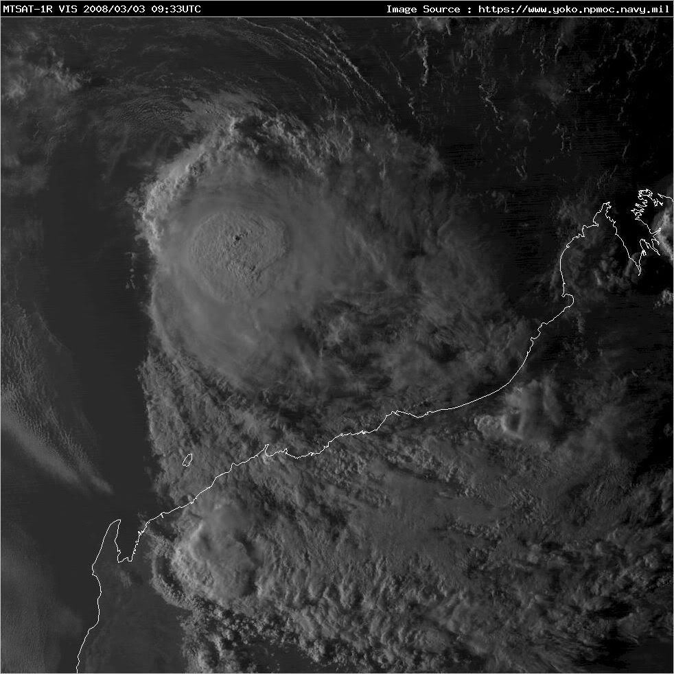
Re: NW Australia: Tropical Cyclone Ophelia
IDW27300
TROPICAL CYCLONE TECHNICAL SUMMARY: AUSTRALIA - WESTERN REGION
Issued by PERTH TROPICAL CYCLONE WARNING CENTRE
at: 0652 UTC 03/03/2008
Name: Ophelia
Data At: 0600 UTC
Latitude: 16.5S
Longitude: 117.4E
Location Accuracy: within 20 nm (37 km)
Movement Towards: west (270 deg)
Speed of Movement: 8 knots (15 km/h)
Maximum 10-Minute Wind: 50 knots (95 km/h)
Maximum 3-Second Wind Gust: 70 knots (130 km/h)
Central Pressure: 982 hPa
Radius of 34-knot winds NE quadrant: 40 nm (75 km)
Radius of 34-knot winds SE quadrant: 55 nm (100 km)
Radius of 34-knot winds SW quadrant: 60 nm (110 km)
Radius of 34-knot winds NW quadrant: 50 nm (95 km)
Radius of 48-knot winds NE quadrant: 20 nm (37 km)
Radius of 48-knot winds SE quadrant: 20 nm (37 km)
Radius of 48-knot winds SW quadrant: 20 nm (37 km)
Radius of 48-knot winds NW quadrant: 20 nm (37 km)
Radius of 64-knot winds:
Radius of Maximum Winds: 10 nm (19 km)
Dvorak Intensity Code: T3.0/3.5/W0.5/12HRS
Pressure of outermost isobar: 1006 hPa
Radius of outermost closed isobar: 90 nm (165 km)
Storm Depth: Deep
FORECAST DATA
Date/Time : Location : Loc. Accuracy: Max Wind : Central Pressure
(UTC) : degrees : nm (km): knots(km/h): hPa
+12: 03/1800: 16.8S 115.4E: 040 (075): 055 (100): 974
+24: 04/0600: 17.4S 113.2E: 065 (120): 055 (100): 974
+36: 04/1800: 18.0S 110.8E: 085 (155): 050 (095): 982
+48: 05/0600: 18.7S 109.1E: 105 (195): 045 (085): 986
REMARKS:
Ophelia is a small system that has weakened under N/NE shear in the last 18 hours.
Dvorak analysis: FT of 3.0 based on shear pattern (LLCC <0.5deg from deep convection)
supported by MET, with CI at 3.5. Weakening is also supported by the 03/01UTC ASCAT pass.
Being such a small system, fluctuations in intensity are to be expected and some
re-intensification is still possible overnight should the environmental shear drop even by a small degree as some models suggest. Despite the recent weakening trend, a CI=3.5-4.0 (50-55
knots) intensity is forecast through the next 36 hour period.
Thereafter weakening seems more likely with indications of increasing N/NW shear and
movement over cooler SST particularly as it moves west of 110E.
Models maintain a consistent west to west southwest track roughly parallel to the Pilbara coast
under the influence of a persisting mid-level ridge to the south.
Notes:
This product is issued every six hours; the Cyclone Advices (Watches and Warnings) are
usually issued more frequently and contain more useful information for coastal communities.
Time Conversion from UTC to local:
WST add 8 hrs (Add another hour for daylight saving)
CST add 9 hrs 30 min
EST add 10 hrs (Add another hour for daylight saving)
==
The next bulletin for this system will be issued by: 03/1300 UTC by Perth TCWC
0 likes


Who is online
Users browsing this forum: No registered users and 14 guests