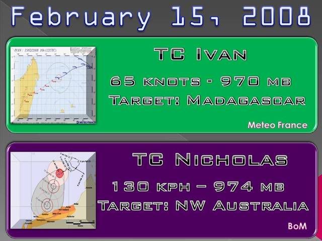
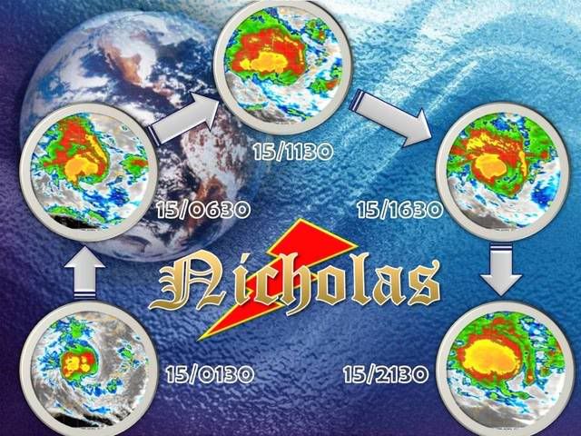
NW Australia: Tropical Cyclone Nicholas (19S)
Moderator: S2k Moderators
-
Crostorm

- Category 5

- Posts: 2060
- Age: 49
- Joined: Mon Dec 25, 2006 3:51 pm
- Location: Croatia-Europe
- Contact:
Re: W.Australia-Tropical Cyclone Nicholas (19S)
It possible be that Nicholas will be intense like George?
Nicholas vs George


http://www.bom.gov.au/announcements/sev ... 0303.shtml
Nicholas vs George
http://www.bom.gov.au/announcements/sev ... 0303.shtml
0 likes
-
Ed Mahmoud
Re: W.Australia-Tropical Cyclone Nicholas (19S)
If they issue 'hurricane force wind warnings' why don't they get with the program and call them 'hurricanes'? Less typing than 'tropical cyclone'.
0 likes
-
HURAKAN

- Professional-Met

- Posts: 46086
- Age: 37
- Joined: Thu May 20, 2004 4:34 pm
- Location: Key West, FL
- Contact:
Re: W.Australia-Tropical Cyclone Nicholas (19S)
Ed Mahmoud wrote:If they issue 'hurricane force wind warnings' why don't they get with the program and call them 'hurricanes'? Less typing than 'tropical cyclone'.


0 likes


-
Crostorm
- Category 5
- Posts: 2060
- Age: 49
- Joined: Mon Dec 25, 2006 3:51 pm
- Location: Croatia-Europe
- Contact:
Re: W.Australia-Tropical Cyclone Nicholas (19S)
IDW24200
Australian Government Bureau of Meteorology
Western Australia
Media: The Standard Emergency Warning Signal should NOT be used with this
[warning.
TOP PRIORITY FOR IMMEDIATE BROADCAST
TROPICAL CYCLONE ADVICE NUMBER 34
Issued at 3:55 am WDT on Saturday, 16 February 2008
BY THE BUREAU OF METEOROLOGY
TROPICAL CYCLONE WARNING CENTRE PERTH
A Cyclone WARNING is current for coastal areas from Mardie to Pardoo.
A Cyclone WATCH is current for coastal areas from Coral Bay to Mardie.
The Cyclone Warning for coastal areas from Pardoo to Wallal has been cancelled.
At 3:00 am WDT Tropical Cyclone Nicholas was estimated to be
445 kilometres north of Port Hedland and
490 kilometres north northeast of Karratha and
moving west southwest at 16 kilometres per hour.
Nicholas is moving slightly faster towards the west southwest and is expected to
take a south to southwest track towards the Pilbara coast later today and during
Sunday. Nicholas is expected to further intensify during the next two days and
there is a risk of a severe tropical cyclone crossing the Pilbara coast late on
Sunday or on Monday.
It is possible that gales could affect coastal communities between Pardoo and
Mardie on Sunday and then extend to adjacent inland parts. Gales may develop in
coastal areas between Mardie and Coral Bay later on Sunday or on Monday.
Details of Tropical Cyclone Nicholas at 3:00 am WDT:
Centre located near...... 16.4 degrees South 117.8 degrees East
Location accuracy........ within 55 kilometres
Recent movement.......... towards the west southwest at 16 kilometres per hour
Wind gusts near centre... 150 kilometres per hour
Severity category........ 2
Central pressure......... 966 hectoPascals
FESA-State Emergency Service advises of the following community alerts:
BLUE ALERT: People in or near coastal Pilbara communities between Wallal and
Mardie, including Wallal, Pardoo, Port Hedland, Wickham, Point Samson,
Roebourne, Karratha, Dampier and Mardie.
People in coastal and adjacent inland Pilbara communities should listen for the
next advice.
The next advice will be issued by 7:00 am WDT Saturday 16 February.
Cyclone advices and State Emergency Service Community Alerts are available by
dialling 1300 659 210
0 likes
-
Crostorm
- Category 5
- Posts: 2060
- Age: 49
- Joined: Mon Dec 25, 2006 3:51 pm
- Location: Croatia-Europe
- Contact:
Re: W.Australia-Tropical Cyclone Nicholas (19S)
IDW27400
TROPICAL CYCLONE TECHNICAL SUMMARY: AUSTRALIA - WESTERN REGION
Issued by PERTH TROPICAL CYCLONE WARNING CENTRE
at: 1915 UTC 15/02/2008
Name: Nicholas
Data At: 1800 UTC
Latitude: 16.4S
Longitude: 117.8E
Location Accuracy: within 30 nm (55 km)
Movement Towards: west southwest (257 deg)
Speed of Movement:9 knots (16 km/h)
Maximum 10-Minute Wind: 55 knots (100 km/h)
Maximum 3-Second Wind Gust: 80 knots (150 km/h)
Central Pressure: 966 hPa
Radius of 34-knot winds NE quadrant: 90 nm (165 km)
Radius of 34-knot winds SE quadrant: 90 nm (165 km)
Radius of 34-knot winds SW quadrant: 90 nm (165 km)
Radius of 34-knot winds NW quadrant: 90 nm (165 km)
Radius of 48-knot winds NE quadrant: 40 nm (75 km)
Radius of 48-knot winds SE quadrant: 40 nm (75 km)
Radius of 48-knot winds SW quadrant: 40 nm (75 km)
Radius of 48-knot winds NW quadrant: 40 nm (75 km)
Radius of 64-knot winds:
Radius of Maximum Winds: 20 nm (37 km)
Dvorak Intensity Code: T4.0/4.0/D1.0/24HRS
Pressure of outermost isobar: 998 hPa
Radius of outermost closed isobar: 120 nm (220 km)
Storm Depth: Deep
FORECAST DATA
Date/Time : Location : Loc. Accuracy: Max Wind : Central Pressure
(UTC) : degrees : nm (km): knots(km/h): hPa
+12: 16/0600: 17.3S 116.8E: 060 (110): 070 (130): 956
+24: 16/1800: 18.1S 116.3E: 080 (150): 080 (150): 944
+36: 17/0600: 19.1S 115.7E: 100 (185): 090 (165): 932
+48: 17/1800: 20.1S 114.9E: 120 (220): 100 (185): 918
REMARKS:
Nicholas is showing increasing curvature in the deep convection in both Infrared and microwave imagery and improving high level outflow is evident as it moves into a region of reduced vertical wind shear. The system is expected to continue intensification along the standard Dvorak rate and reach a T 5.0 in 24 hours.
Recent westerly steering by the mid level ridge is forecast to decrease and the system is expected to begin to move on a more south westerly track over the next 6 to 12 hours.
This motion is expected to continue in the long term in accordance with the consensus of model guidance.
Notes:
This product is issued every six hours; the Cyclone Advices (Watches and Warnings) are
usually issued more frequently and contain more useful information for coastal communities.
Time Conversion from UTC to local:
WST add 8 hrs (Add another hour for daylight saving)
CST add 9 hrs 30 min
EST add 10 hrs (Add another hour for daylight saving)
==
The next bulletin for this system will be issued by: 16/0100 UTC by Perth TCWC
0 likes


-
Squarethecircle
- Category 5
- Posts: 2165
- Joined: Fri Oct 19, 2007 4:00 pm
- Location: Fairfax, VA
-
Crostorm
- Category 5
- Posts: 2060
- Age: 49
- Joined: Mon Dec 25, 2006 3:51 pm
- Location: Croatia-Europe
- Contact:
Re: W.Australia-Tropical Cyclone Nicholas (19S)
Western Australian Emergency Authorities have reissued a cyclone alert for the north-western coastal areas of the state.
Cyclone Nicholas is more than 400 kilometres north of Port Hedland, travelling at 55 kilometres per hour.

The Weather Bureau says the category two storm is expected to intensify and could reach the Pilbara coast by tomorrow afternoon.
Communities from Dampier to Pardoo are urged to prepare their homes and arrange emergency supplies and accommodation if necessary.
http://www.weatherzone.com.au/news/bure ... rning/8643
Cyclone Nicholas is more than 400 kilometres north of Port Hedland, travelling at 55 kilometres per hour.
The Weather Bureau says the category two storm is expected to intensify and could reach the Pilbara coast by tomorrow afternoon.
Communities from Dampier to Pardoo are urged to prepare their homes and arrange emergency supplies and accommodation if necessary.
http://www.weatherzone.com.au/news/bure ... rning/8643
0 likes
-
HURAKAN
- Professional-Met
- Posts: 46086
- Age: 37
- Joined: Thu May 20, 2004 4:34 pm
- Location: Key West, FL
- Contact:
Australian Government Bureau of Meteorology
Western Australia
Media: The Standard Emergency Warning Signal should NOT be used with this
warning.
TOP PRIORITY FOR IMMEDIATE BROADCAST
TROPICAL CYCLONE ADVICE NUMBER 35
Issued at 6:40 am WDT on Saturday, 16 February 2008
BY THE BUREAU OF METEOROLOGY
TROPICAL CYCLONE WARNING CENTRE PERTH
A Cyclone WARNING is current for coastal areas from Mardie to Pardoo.
A Cyclone WATCH is current for coastal areas from Coral Bay to Mardie and
adjacent inland parts.
At 6:00 am WDT Tropical Cyclone Nicholas was relocated to be
475 kilometres north of Port Hedland and
530 kilometres north northeast of Karratha and
moving west at 12 kilometres per hour.
Nicholas is moving on a westerly track but is expected to take a south southwest
track towards the Pilbara coast later today and during Sunday. Nicholas is
expected to further intensify during the next two days and there is a risk of a
severe tropical cyclone crossing the Pilbara coast on Monday or Tuesday.
It is possible that gales could affect coastal communities between Pardoo and
Mardie on Sunday and then extend to adjacent inland parts on Monday. Gales may
develop in coastal areas between Mardie and Coral Bay on Monday or Tuesday.
Details of Tropical Cyclone Nicholas at 6:00 am WDT:
Centre relocated near.... 16.1 degrees South 118.0 degrees East
Location accuracy........ within 55 kilometres
Recent movement.......... towards the west at 12 kilometres per hour
Wind gusts near centre... 155 kilometres per hour
Severity category........ 2
Central pressure......... 964 hectoPascals
FESA-State Emergency Service advises of the following community alerts:
BLUE ALERT: People in or near coastal Pilbara communities between Pardoo and
Mardie, including Port Hedland, Wickham, Point Samson, Roebourne, Karratha,
Dampier and Mardie.
ALL CLEAR WITH CAUTION: People in communities from Pardoo to Wallal are advised
to proceed with caution.
People in coastal and adjacent inland Pilbara communities should listen for the
next advice.
The next advice will be issued by 10:00 am WDT Saturday 16 February.
Cyclone advices and State Emergency Service Community Alerts are available by
dialling 1300 659 210
A map showing the track of the cyclone is available at:
http://www.bom.gov.au/weather/cyclone
0 likes
-
Squarethecircle
- Category 5
- Posts: 2165
- Joined: Fri Oct 19, 2007 4:00 pm
- Location: Fairfax, VA


IDW24200
Australian Government Bureau of Meteorology
Western Australia
Media: The Standard Emergency Warning Signal should NOT be used with this
warning.
TOP PRIORITY FOR IMMEDIATE BROADCAST
TROPICAL CYCLONE ADVICE NUMBER 36
Issued at 9:55 am WDT on Saturday, 16 February 2008
BY THE BUREAU OF METEOROLOGY
TROPICAL CYCLONE WARNING CENTRE PERTH
A Cyclone WARNING is current for coastal areas from Pardoo to Mardie.
A Cyclone WATCH is current for coastal areas from Mardie to Coral Bay and
adjacent inland parts of the Warning zone
At 9:00 am WDT Tropical Cyclone Nicholas was relocated to be
545 kilometres north northeast of Karratha and
780 kilometres north northeast of Exmouth and
moving west at 7 kilometres per hour.
Nicholas has been moving on a westerly track but is expected to take a south
southwest track towards the Pilbara coast later today and during Sunday.
Nicholas is expected to further intensify during the next two days and there is
a risk of a severe tropical cyclone crossing the Pilbara coast on late Monday or
Tuesday.
It is possible that gales could affect coastal communities between Pardoo and
Mardie on Sunday and then extend to adjacent inland parts on Monday. Gales may
develop in coastal areas between Mardie and Coral Bay on Monday or Tuesday.
Details of Tropical Cyclone Nicholas at 9:00 am WDT:
Centre relocated near...... 16.0 degrees South 118.1 degrees East
Location accuracy........ within 55 kilometres
Recent movement.......... towards the west at 7 kilometres per hour
Wind gusts near centre... 150 kilometres per hour
Severity category........ 2
Central pressure......... 966 hectoPascals
FESA-State Emergency Service advises of the following community alerts:
BLUE ALERT: People in or near coastal Pilbara communities between Pardoo and
Mardie, including Port Hedland, Wickham, Point Samson, Roebourne, Karratha,
Dampier and Mardie.
People in coastal and adjacent inland Pilbara communities should listen for the
next advice.
The next advice will be issued by 1:00 pm WDT Saturday 16 February.
Cyclone advices and State Emergency Service Community Alerts are available by
dialling 1300 659 210
A map showing the track of the cyclone is available at:
http://www.bom.gov.au/weather/cyclone
0 likes
-
HurricaneRobert
- Category 3

- Posts: 812
- Joined: Fri May 18, 2007 9:31 pm

-
Crostorm
- Category 5
- Posts: 2060
- Age: 49
- Joined: Mon Dec 25, 2006 3:51 pm
- Location: Croatia-Europe
- Contact:
Re: W.Australia-Tropical Cyclone Nicholas (19S)
IDW24200
Australian Government Bureau of Meteorology
Western Australia
Media: The Standard Emergency Warning Signal should NOT be used with this
warning.
TOP PRIORITY FOR IMMEDIATE BROADCAST
TROPICAL CYCLONE ADVICE NUMBER 38
Issued at 3:50 pm WDT on Saturday, 16 February 2008
BY THE BUREAU OF METEOROLOGY
TROPICAL CYCLONE WARNING CENTRE PERTH
A Cyclone WARNING is current for coastal areas from Pardoo to Mardie.
A Cyclone WATCH is current for coastal areas from Mardie to Coral Bay and
adjacent inland parts of both the Watch and the Warning zones
At 3:00 pm WDT Severe Tropical Cyclone Nicholas was relocated to be
455 kilometres north northeast of Karratha and
710 kilometres northeast of Exmouth and
moving south southwest at 8 kilometres per hour.
Nicholas has intensified into a Severe Tropical Cyclone and has turned towards
the Pilbara coast. It is now moving in a south southwest direction and is
expected to continue to track towards the coast over the next two days. There
is a significant risk of impact from a Severe Tropical Cyclone on the Pilbara
coast as early as Sunday night, but it is more likely on Monday or Tuesday.
It is possible that gales could affect coastal communities between Pardoo and
Mardie on Sunday and then extend to adjacent inland parts on Monday. Gales may
develop in coastal areas between Mardie and Exmouth on Monday and extend south
and inland by late Monday or on Tuesday.
Details of Severe Tropical Cyclone Nicholas at 3:00 pm WDT:
Centre relocated near.... 16.8 degrees South 118.1 degrees East
Location accuracy........ within 55 kilometres
Recent movement.......... towards the south southwest at 8 kilometres per hour
Wind gusts near centre... 170 kilometres per hour
Severity category........ 3
Central pressure......... 960 hectoPascals
FESA-State Emergency Service advises of the following community alerts:
BLUE ALERT: People in or near coastal Pilbara communities between Pardoo and
Mardie, including Port Hedland, Wickham, Point Samson, Roebourne, Karratha,
Dampier and Mardie.
People in coastal and adjacent inland Pilbara communities should listen for the
next advice.
The next advice will be issued by 7:00 pm WDT Saturday 16 February.
Cyclone advices and State Emergency Service Community Alerts are available by
dialling 1300 659 210
A map showing the track of the cyclone is available at:
http://www.bom.gov.au/weather/cyclone
0 likes
Who is online
Users browsing this forum: No registered users and 18 guests