
IDW27300
TROPICAL CYCLONE TECHNICAL SUMMARY: AUSTRALIA - WESTERN REGION
Issued by PERTH TROPICAL CYCLONE WARNING CENTRE
at: 0114 UTC 25/03/2008
Name: Tropical Low
Data At: 0000 UTC
Latitude: 14.2S
Longitude: 104.0E
Location Accuracy: within 30 nm (55 km)
Movement Towards: near stationary
Speed of Movement: 6 knots (12 km/h)
Maximum 10-Minute Wind: 30 knots (55 km/h)
Maximum 3-Second Wind Gust: 45 knots (85 km/h)
Central Pressure: 996 hPa
Radius of 34-knot winds NE quadrant:
Radius of 34-knot winds SE quadrant:
Radius of 34-knot winds SW quadrant:
Radius of 34-knot winds NW quadrant: 90 nm (165 km)
Radius of 48-knot winds NE quadrant:
Radius of 48-knot winds SE quadrant:
Radius of 48-knot winds SW quadrant:
Radius of 48-knot winds NW quadrant:
Radius of 64-knot winds:
Radius of Maximum Winds:
Dvorak Intensity Code: T2.5/2.5/S0.0/24HRS
Pressure of outermost isobar: 1006 hPa
Radius of outermost closed isobar: 210 nm (390 km)
Storm Depth: Medium
FORECAST DATA
Date/Time : Location : Loc. Accuracy: Max Wind : Central Pressure
(UTC) : degrees : nm (km): knots(km/h): hPa
+12: 25/1200: 15.2S 104.5E: 050 (095): 040 (075): 990
+24: 26/0000: 15.9S 104.6E: 070 (130): 050 (095): 982
+36: 26/1200: 17.0S 105.2E: 100 (185): 055 (100): 974
+48: 27/0000: 18.5S 105.8E: 130 (240): 055 (100): 974
REMARKS:
Although convection has been sustained to the northwest of the low level circulation centre, the
curvature of the convection has not improved overnight. The system remains under moderate
shear (15-20 knots) with the LLCC to the east of the convection, although there is good outflow
in upper levels to the north and south.
Dvorak: FT/CI of 2.5 based on DT of 2.5 - curved band 0.5 wrap, which is in good agreement with MET of 2.5. NW quadrant gales are likely under the ongoing convection supported by Quickscat.
Intensification is expected to resume on the expectation the shear reduces although the
forecast intensity is held at 55 knots as the system begins to move over cooler SSTs as the
system moves to the south southeast.
Model guidance is in reasonable agreement with a forecast south to southeast track in the next
48 hours under the influence of a ridge to the east and an amplifying upper trough to the
southwest. hours under the influence of a ridge to the east and an amplifying upper trough to
the southwest.
Notes:
This product is issued every six hours; the Cyclone Advices (Watches and Warnings) are
usually issued more frequently and contain more useful information for coastal communities.
Time Conversion from UTC to local:
WST add 8 hrs (Add another hour for daylight saving)
CST add 9 hrs 30 min
EST add 10 hrs (Add another hour for daylight saving)
==
he next bulletin for this system will be issued by: 25/0700 UTC by Perth TCWC.
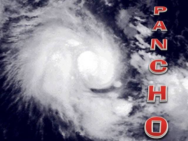
South Indian Ocean:Tropical Depression Ex-Pancho (潘乔 TC26S)
Moderator: S2k Moderators

Re: South Indian Ocean - Tropical Storm 26S
Pancho has arrived. Can a Mod please change the title of this topic.

0 likes

Re: South Indian Ocean - Tropical Cyclone Pancho (TC26S)

IDW27300
TROPICAL CYCLONE TECHNICAL SUMMARY: AUSTRALIA - WESTERN REGION
Issued by PERTH TROPICAL CYCLONE WARNING CENTRE
at: 0718 UTC 25/03/2008
Name: PANCHO
Data At: 0600 UTC
Latitude: 14.3S
Longitude: 104.3E
Location Accuracy: within 30 nm (55 km)
Movement Towards: southeast (145 deg)
Speed of Movement: 5 knots (9 km/h)
Maximum 10-Minute Wind: 35 knots (65 km/h)
Maximum 3-Second Wind Gust: 50 knots (95 km/h)
Central Pressure: 992 hPa
Radius of 34-knot winds NE quadrant: 20 nm (37 km)
Radius of 34-knot winds SE quadrant: 20 nm (37 km)
Radius of 34-knot winds SW quadrant: 120 nm (220 km)
Radius of 34-knot winds NW quadrant: 120 nm (220 km)
Radius of 48-knot winds NE quadrant:
Radius of 48-knot winds SE quadrant:
Radius of 48-knot winds SW quadrant:
Radius of 48-knot winds NW quadrant:
Radius of 64-knot winds:
Radius of Maximum Winds:
Dvorak Intensity Code: T3.0/3.0/D0.5/12HRS
Pressure of outermost isobar: 1006 hPa
Radius of outermost closed isobar: 220 nm (405 km)
Storm Depth: Deep
FORECAST DATA
Date/Time : Location : Loc. Accuracy: Max Wind : Central Pressure
(UTC) : degrees : nm (km): knots(km/h): hPa
+12: 25/1800: 15.2S 104.6E: 050 (095): 045 (085): 986
+24: 26/0600: 16.3S 105.0E: 070 (130): 050 (095): 982
+36: 26/1800: 17.9S 105.5E: 095 (175): 055 (100): 974
+48: 27/0600: 19.7S 106.1E: 120 (220): 060 (110): 972
REMARKS:
Sustained convection remains to the west of the low level circulation centre with evidence of
decreasing shear in the previous 6-12 hours. Upper level outflow remains favourable for
development.
Dvorak: FT/CI of 3.0 based on DT and MET of 3.0 - with LLCC on edge of the deep convection using shear pattern. Gales are most likely in western quadrants but should increase in eastern quadrants as the shear reduces.
Further intensification is expected on the expectation the shear reduces although the
forecast intensity is held at 60 knots as the system begins to move over cooler SSTs and then
encounters increasing NW shear south of 20S.
Model guidance is in reasonable agreement with a forecast south to southeast track in the next
48 hours under the influence of a ridge to the east and an amplifying upper trough to the
southwest.
Notes:
This product is issued every six hours; the Cyclone Advices (Watches and Warnings) are
usually issued more frequently and contain more useful information for coastal communities.
Time Conversion from UTC to local:
WST add 8 hrs (Add another hour for daylight saving)
CST add 9 hrs 30 min
EST add 10 hrs (Add another hour for daylight saving)
==
he next bulletin for this system will be issued by: 25/1300 UTC by Perth TCWC.
0 likes


Re: South Indian Ocean - Tropical Cyclone Pancho (潘乔 TC26S)
IDW27300
TROPICAL CYCLONE TECHNICAL SUMMARY: AUSTRALIA - WESTERN REGION
Issued by PERTH TROPICAL CYCLONE WARNING CENTRE
at: 1240 UTC 25/03/2008
Name: Pancho
Data At: 1200 UTC
Latitude: 14.6S
Longitude: 104.5E
Location Accuracy: within 30 nm (55 km)
Movement Towards: south southeast (157 deg)
Speed of Movement: 5 knots (9 km/h)
Maximum 10-Minute Wind: 45 knots (85 km/h)
Maximum 3-Second Wind Gust: 65 knots (120 km/h)
Central Pressure: 986 hPa
Radius of 34-knot winds NE quadrant: 60 nm (110 km)
Radius of 34-knot winds SE quadrant: 60 nm (110 km)
Radius of 34-knot winds SW quadrant: 120 nm (220 km)
Radius of 34-knot winds NW quadrant: 120 nm (220 km)
Radius of 48-knot winds NE quadrant:
Radius of 48-knot winds SE quadrant:
Radius of 48-knot winds SW quadrant:
Radius of 48-knot winds NW quadrant:
Radius of 64-knot winds:
Radius of Maximum Winds:
Dvorak Intensity Code: T3.0/3.0/D0.5/24HRS
Pressure of outermost isobar: 1006 hPa
Radius of outermost closed isobar: 240 nm (445 km)
Storm Depth: Deep
FORECAST DATA
Date/Time : Location : Loc. Accuracy: Max Wind : Central Pressure
(UTC) : degrees : nm (km): knots(km/h): hPa
+12: 26/0000: 15.5S 104.8E: 050 (095): 050 (095): 982
+24: 26/1200: 16.8S 105.3E: 070 (130): 055 (100): 974
+36: 27/0000: 18.3S 106.2E: 090 (165): 060 (110): 972
+48: 27/1200: 20.2S 106.8E: 115 (215): 055 (100): 976
REMARKS:
Sustained convection is beginning to wrap around the low level circulation centre with evidence of decreasing shear. Upper level outflow remains favourable for development.
Dvorak: FT/CI of 3.0 based on DT of 3.0 (using 3hr averaged curved band - wrap of 0.7 and irregular CDO >1.5 degrees).
Pancho is expected to intensify in the next 36 hours although the forecast intensity is held at 60 knots as the system begins to move over cooler SSTs and then encounters increasing NW shear south of 20S.
Model guidance is in reasonable agreement with a forecast south to southeast track in the next
48 hours under the influence of a ridge to the east and an amplifying upper trough to the
southwest.
Notes:
This product is issued every six hours; the Cyclone Advices (Watches and Warnings) are
usually issued more frequently and contain more useful information for coastal communities.
Time Conversion from UTC to local:
WST add 8 hrs (Add another hour for daylight saving)
CST add 9 hrs 30 min
EST add 10 hrs (Add another hour for daylight saving)
==
he next bulletin for this system will be issued by: 25/1900 UTC by Perth TCWC.
0 likes


AXAU01 APRF 251349
IDW27600
TROPICAL CYCLONE TECHNICAL BULLETIN: AUSTRALIA - WESTERN REGION
Issued by PERTH TROPICAL CYCLONE WARNING CENTRE
at: 1349 UTC 25/03/2008
Name: Pancho
Data At: 1200 UTC
Latitude: 14.7S
Longitude: 103.8E
Location Accuracy: within 30 nm [55 km]
Movement Towards: south southwest [196 deg]
Speed of Movement: 5 knots [10 km/h]
Maximum 10-Minute Wind: 45 knots [85 km/h]
Maximum 3-Second Wind Gust: 65 knots [120 km/h]
Central Pressure: 986 hPa
Radius of 34-knot winds NE quadrant: 60 nm [110 km]
Radius of 34-knot winds SE quadrant: 60 nm [110 km]
Radius of 34-knot winds SW quadrant: 120 nm [220 km]
Radius of 34-knot winds NW quadrant: 120 nm [220 km]
Radius of 48-knot winds NE quadrant:
Radius of 48-knot winds SE quadrant:
Radius of 48-knot winds SW quadrant:
Radius of 48-knot winds NW quadrant:
Radius of 64-knot winds:
Radius of Maximum Winds:
Dvorak Intensity Code: T3.0/3.0/D0.5/24HRS
Pressure of outermost isobar: 1006 hPa
Radius of outermost closed isobar: 240 nm [445 km]
Storm Depth: Deep
FORECAST DATA
Date/Time : Location : Loc. Accuracy: Max Wind : Central Pressure
[UTC] : degrees : nm [km]: knots[km/h]: hPa
+12: 26/0000: 15.7S 104.0E: 050 [095]: 050 [095]: 982
+24: 26/1200: 16.9S 104.5E: 070 [130]: 055 [100]: 974
+36: 27/0000: 18.4S 105.4E: 090 [165]: 060 [110]: 972
+48: 27/1200: 20.3S 106.0E: 115 [215]: 055 [100]: 976
+60: 28/0000: 21.7S 106.1E: 145 [270]: 050 [095]: 984
+72: 28/1200: 22.9S 105.9E: 175 [325]: 040 [075]: 992
REMARKS:
Reissued due to relocation based on receipt of 25 1056 UTC Quickscat.
Sustained convection is beginning to wrap around the low level circulation
centre with evidence of decreasing shear. Upper level outflow remains favourable
for development.
Dvorak: FT/CI of 3.0 based on DT of 3.0 [using 3hr averaged curved band - wrap
of 0.7 and irregular CDO >1.5 degrees].
Pancho is expected to intensify in the next 36 hours although the forecast
intensity is held at 60 knots as the system begins to move over cooler SSTs and
then encounters increasing NW shear south of 20S.
Model guidance is in reasonable agreement with a forecast south to southeast
track in the next
48 hours under the influence of a ridge to the east and an amplifying upper
trough to the
southwest.
==
The next bulletin for this system will be issued by: 25/1900 UTC by Perth TCWC.
0 likes

-
HURAKAN

- Professional-Met

- Posts: 46086
- Age: 37
- Joined: Thu May 20, 2004 4:34 pm
- Location: Key West, FL
- Contact:
HIGH SEAS WEATHER WARNING FOR METAREA 10 ISSUED BY THE
AUSTRALIAN BUREAU OF METEOROLOGY TROPICAL CYCLONE WARNING
CENTRE PERTH AT 1828UTC 25 MARCH 2008
STORM FORCE WIND WARNING FOR THE WESTERN AREA
Please be aware, wind gusts can be a further 40 percent stronger than the
averages given here, and maximum waves may be up to twice the height.
SITUATION
At 1800 UTC Tropical Cyclone Pancho was located within 30 nautical miles of
latitude fifteen decimal two south [15.2S]
longitude one hundred and three decimal nine east [103.9E]
Recent movement : south at 5 knots
Maximum winds : 50 knots
Central pressure: 982 hPa
AREA AFFECTED
Within 90 nautical miles of the centre in eastern quadrants extending to 120
nautical miles in western quadrants.
FORECAST
Maximum winds to 50 knots near the centre increasing to 60 knots by 1800 UTC 26
March.
Winds above 34 knots within 90 nautical miles of the centre in eastern quadrants
extending to 120 nautical miles in western quadrants with rough seas and
moderate swell.
Winds above 48 knots within 30 nautical miles of the centre with very rough seas
and moderate swell.
Forecast positions
At 0600 UTC 26 March: Within 50 nautical miles of 16.3 south 104.2 east
Central pressure 974 hPa.
Winds to 55 knots near centre.
At 1800 UTC 26 March: Within 70 nautical miles of 17.6 south 105.0 east
Central pressure 972 hPa.
Winds to 60 knots near centre.
REMARKS
All ships in the area please send weather reports every three hours.
Regular weather observing ships use normal channels.
Next warning will be issued by 0100 UTC 26 March 2008.
WEATHER PERTH
0 likes


Re: South Indian Ocean - Tropical Cyclone Pancho (潘乔 TC26S)

IDW27300
TROPICAL CYCLONE TECHNICAL SUMMARY: AUSTRALIA - WESTERN REGION
Issued by PERTH TROPICAL CYCLONE WARNING CENTRE
at: 0112 UTC 26/03/2008
Name: Pancho
Data At: 0000 UTC
Latitude: 15.3S
Longitude: 104.4E
Location Accuracy: within 30 nm (55 km)
Movement Towards: southeast (141 deg)
Speed of Movement: 4 knots (7 km/h)
Maximum 10-Minute Wind: 55 knots (100 km/h)
Maximum 3-Second Wind Gust: 80 knots (150 km/h)
Central Pressure: 972 hPa
Radius of 34-knot winds NE quadrant: 100 nm (185 km)
Radius of 34-knot winds SE quadrant: 100 nm (185 km)
Radius of 34-knot winds SW quadrant: 120 nm (220 km)
Radius of 34-knot winds NW quadrant: 120 nm (220 km)
Radius of 48-knot winds NE quadrant: 30 nm (55 km)
Radius of 48-knot winds SE quadrant: 30 nm (55 km)
Radius of 48-knot winds SW quadrant: 30 nm (55 km)
Radius of 48-knot winds NW quadrant: 30 nm (55 km)
Radius of 64-knot winds:
Radius of Maximum Winds:
Dvorak Intensity Code: T4.0/4.0/D1.0/12HRS
Pressure of outermost isobar: 1004 hPa
Radius of outermost closed isobar: 250 nm (465 km)
Storm Depth: Deep
FORECAST DATA
Date/Time : Location : Loc. Accuracy: Max Wind : Central Pressure
(UTC) : degrees : nm (km): knots(km/h): hPa
+12: 26/1200: 16.4S 104.8E: 050 (095): 065 (120): 966
+24: 27/0000: 17.8S 105.1E: 070 (130): 075 (140): 958
+36: 27/1200: 19.8S 105.4E: 105 (195): 080 (150): 950
+48: 28/0000: 21.3S 105.7E: 140 (260): 080 (150): 950
REMARKS:
Microwave imagery shows sustained convection is wrapping around the low level circulation
centre and the system appears to be more symmetrical. Upper level outflow remains
favourable for development.
Dvorak: FT/CI of 4.0 based on DT of 4.0 - wrap of greater than 1.0
Pancho is expected to intensify in the next 30 hours and begin to weaken at about 60 hours as
the system begins to move over cooler SSTs and then encounters increasing NW shear south of
20S.
Model guidance is in reasonable agreement with a forecast south to southeast track in the next
48 hours under the influence of a ridge to the east and an amplifying upper trough to the
southwest.
Notes:
This product is issued every six hours; the Cyclone Advices (Watches and Warnings) are
usually issued more frequently and contain more useful information for coastal communities.
Time Conversion from UTC to local:
WST add 8 hrs (Add another hour for daylight saving)
CST add 9 hrs 30 min
EST add 10 hrs (Add another hour for daylight saving)
==
he next bulletin for this system will be issued by: 26/0700 UTC by Perth TCWC.
0 likes

Re: South Indian Ocean - Tropical Cyclone Pancho (TC 26S)

IDW27300
TROPICAL CYCLONE TECHNICAL SUMMARY: AUSTRALIA - WESTERN REGION
Issued by PERTH TROPICAL CYCLONE WARNING CENTRE
at: 0710 UTC 26/03/2008
Name: Pancho
Data At: 0600 UTC
Latitude: 15.9S
Longitude: 104.5E
Location Accuracy: within 25 nm (46 km)
Movement Towards: south southeast (157 deg)
Speed of Movement: 6 knots (11 km/h)
Maximum 10-Minute Wind: 60 knots (110 km/h)
Maximum 3-Second Wind Gust: 85 knots (155 km/h)
Central Pressure: 970 hPa
Radius of 34-knot winds NE quadrant: 120 nm (220 km)
Radius of 34-knot winds SE quadrant: 120 nm (220 km)
Radius of 34-knot winds SW quadrant: 130 nm (240 km)
Radius of 34-knot winds NW quadrant: 120 nm (220 km)
Radius of 48-knot winds NE quadrant: 30 nm (55 km)
Radius of 48-knot winds SE quadrant: 30 nm (55 km)
Radius of 48-knot winds SW quadrant: 30 nm (55 km)
Radius of 48-knot winds NW quadrant: 30 nm (55 km)
Radius of 64-knot winds:
Radius of Maximum Winds:
Dvorak Intensity Code: T4.0/4.0/D1.0/24HRS
Pressure of outermost isobar: 1004 hPa
Radius of outermost closed isobar: 250 nm (465 km)
Storm Depth: Deep
FORECAST DATA
Date/Time : Location : Loc. Accuracy: Max Wind : Central Pressure
(UTC) : degrees : nm (km): knots(km/h): hPa
+12: 26/1800: 17.1S 105.1E: 050 (095): 070 (130): 962
+24: 27/0600: 19.0S 105.7E: 080 (150): 080 (150): 950
+36: 27/1800: 20.8S 106.3E: 110 (205): 080 (150): 950
+48: 28/0600: 22.2S 106.4E: 140 (260): 070 (130): 962
REMARKS:
Convection has become more organised about the centre in the last 12 hours and the system
appears to be more symmetrical consistent with decreasing environmental shear and
favourable upper level outflow.
Dvorak: FT/CI of 4.0 based on DT of 4.0 - wrap of greater than 1.0.
Further intensification can be expected in the next 24 hours with ongoing low wind shear and
favourable upper outflow. The intensity may then plateau as SSTs fall below 27C and then
increasing upper level NW'lies begin to impact the system, particularly beyond 36-48 hour
timeframe.
The range of model guidance favour a southerly or southeasterly track in the next 48 hours.
The system may then slow and becoming strongly influenced by an amplifying upper level low
to the southwest.
Notes:
This product is issued every six hours; the Cyclone Advices (Watches and Warnings) are
usually issued more frequently and contain more useful information for coastal communities.
Time Conversion from UTC to local:
WST add 8 hrs (Add another hour for daylight saving)
CST add 9 hrs 30 min
EST add 10 hrs (Add another hour for daylight saving)
==
he next bulletin for this system will be issued by: 26/1300 UTC by Perth TCWC.
0 likes
South Indian Ocean - Tropical Cyclone Pancho (TC 26S)
Looks like eye may be starting to appear


0 likes
Re: South Indian Ocean - Tropical Cyclone Pancho (潘乔 TC26S)
260900z position near 16.3s 104.7e.
Tropical cyclone (tc) 26s (pancho) located approximately 645 nm west-
northwest of Learmonth, Australia, has tracked south-southeastward at
06 knots over the past 06 hours. Animated multispectral satellite
imagery depicts a consolidating system with a banding eye. Animated
water vapor imagery indicates good dual outflow with poleward flow
enhanced by the upper-level shortwave to the southwest. Upper level
analysis indicate weak vertical wind shear with an anticyclone
located directly over the center. The current intensity is based on
an average of Dvorak estimates ranging from 65 to 77 knots. Tc 26s
is tracking south-southeastward under the steering influence of the
mid-level subtropical ridge positioned east of the system and is
forecast to continue tracking south-southeastward through the
period. The system has tracked slightly east of the previous
forecast and has intensified faster than expected but forecast
reasoning remains unchanged. Tc 26s will track over cooler SST
and lower ocean heat content after tau 24 and will weaken signif-
icantly by tau 48 as vertical wind shear increases. This forecast
is based on the model consensus but is slightly slower. Maximum
significant wave height at 260600z is 20 feet. Next warnings at
262100z and 270900z.//
0 likes


Who is online
Users browsing this forum: No registered users and 17 guests