ATL INVEST 94L: Discussion

Moderator: S2k Moderators

Message
Author
User avatar
vacanechaser
Category 5
Category 5
Posts: 1461
Joined: Wed Dec 03, 2003 9:34 pm
Location: Portsmouth, Va
Contact:

Re: ATL: INVEST 94L: Discussion

#21 Postby vacanechaser » Wed Sep 24, 2008 8:44 am

weatherwoman wrote:
Weatherfreak000 wrote:Dvorak supports STS intensity...LLC clearly present...


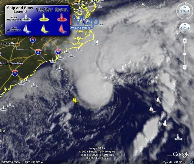
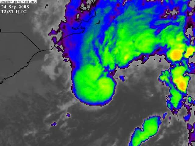
This should be upgraded today. What an amazingly fast development. Convection appears to be wrapping around nicely so I wouldn't expect to see this Subtropical for very long.

Likely it's Subtropical due to pretty high wind sheap from the north...which is somewhat displacing convection from the center....it seems if Wind Shear maps are correct those winds should relax to about the level at least the storm should be able to wrap the convection around.


so are you saying this could be tropical? or stay subtropical


it would suggest they are thinking subtropical at this time... still, could become tropical if it stays out there long enough... will have to see about that though


Jesse V. Bass III
http://www.vastormphoto.com
Hurricane Intercept Research Team
0 likes   

User avatar
HURAKAN
Professional-Met
Professional-Met
Posts: 46086
Age: 37
Joined: Thu May 20, 2004 4:34 pm
Location: Key West, FL
Contact:

#22 Postby HURAKAN » Wed Sep 24, 2008 8:44 am

Image

Convection over LLC. Not a non-tropical characteristic!
0 likes   

seahawkjd
S2K Supporter
S2K Supporter
Posts: 632
Joined: Wed Sep 10, 2003 4:12 pm
Location: Morehead City, NC
Contact:

Re: ATL: INVEST 94L: Discussion

#23 Postby seahawkjd » Wed Sep 24, 2008 8:46 am

How fast and where is this moving towards? How long does it have to sit out there and become something before it makes landfall?
0 likes   

User avatar
HURAKAN
Professional-Met
Professional-Met
Posts: 46086
Age: 37
Joined: Thu May 20, 2004 4:34 pm
Location: Key West, FL
Contact:

#24 Postby HURAKAN » Wed Sep 24, 2008 8:47 am

PCEO - MARITIME-ship
Wednesday Sep. 24 - 12:00 UTC
Air Temperature: 77°F
Dewpoint: 68°F
Wind: NNE at 42 mph
Pressure: 1013.9 mb
Weather: Mostly cloudy
Wave Height: 20 ft
Sea Surface Temp: 82.4°F

Image
0 likes   

User avatar
Lowpressure
S2K Supporter
S2K Supporter
Posts: 2032
Age: 57
Joined: Sun Sep 14, 2003 9:17 am
Location: Charlotte, North Carolina

Re: ATL: INVEST 94L: Discussion

#25 Postby Lowpressure » Wed Sep 24, 2008 8:47 am

Agee, it almost looks like a CDO forming. Large wind field due to interaction with the high.
0 likes   

jinftl
Category 5
Category 5
Posts: 4312
Joined: Tue Aug 31, 2004 4:47 pm
Location: fort lauderdale, fl

Re:

#26 Postby jinftl » Wed Sep 24, 2008 8:49 am

Latest LLC fix is a bit to the right of most of the 'blob' of convection...

24/1145 UTC 32.0N 74.9W

HURAKAN wrote:Image

Convection over LLC. Not a non-tropical characteristic!
0 likes   

User avatar
AJC3
Admin
Admin
Posts: 3878
Age: 60
Joined: Tue Aug 31, 2004 7:04 pm
Location: West Melbourne, Florida
Contact:

Re: ATL: INVEST 94L: Discussion

#27 Postby AJC3 » Wed Sep 24, 2008 8:50 am

jconsor wrote:SSD thinks this is subtropical:

24/1145 UTC 32.0N 74.9W ST2.5 94L -- Atlantic Ocean


Justin, I think that simply reflects that SSD used the Hebert-Poteat technique to estimate intensity rather the the Dvorak technique. As long as the HPC analyst is putting a front out there, they won't be classifying it as an STS.

Image
0 likes   

jinftl
Category 5
Category 5
Posts: 4312
Joined: Tue Aug 31, 2004 4:47 pm
Location: fort lauderdale, fl

Re: ATL: INVEST 94L: Discussion

#28 Postby jinftl » Wed Sep 24, 2008 8:52 am

With High Wind Warnings, Coastal Flood Warnings, and Gale Warnings already up for the area....it is definitely making its presence known already...or put another way, a 55mph wind from a sub-tropical storm is the same as a 55mph from a tropical storm if we were to experience it outside our window.

seahawkjd wrote:How fast and where is this moving towards? How long does it have to sit out there and become something before it makes landfall?
0 likes   

Steve H.
Category 5
Category 5
Posts: 2134
Joined: Sat Oct 19, 2002 9:06 am
Location: Palm Bay, Florida

Re: ATL: INVEST 94L: Discussion

#29 Postby Steve H. » Wed Sep 24, 2008 8:52 am

It is currently moving to the southwest at a pretty good clip under the influence of the strong High pressure to its north. We'll see how long that direction lasts. I'm thinking it might do a loop back to the north at some point - just don't know when. The high needs to move off to the east before that will happen. Currently not sure when that is progged.
0 likes   

User avatar
HURAKAN
Professional-Met
Professional-Met
Posts: 46086
Age: 37
Joined: Thu May 20, 2004 4:34 pm
Location: Key West, FL
Contact:

#30 Postby HURAKAN » Wed Sep 24, 2008 8:55 am

Image
0 likes   

User avatar
Lowpressure
S2K Supporter
S2K Supporter
Posts: 2032
Age: 57
Joined: Sun Sep 14, 2003 9:17 am
Location: Charlotte, North Carolina

Re: ATL: INVEST 94L: Discussion

#31 Postby Lowpressure » Wed Sep 24, 2008 8:56 am

seahawkjd wrote:How fast and where is this moving towards? How long does it have to sit out there and become something before it makes landfall?

Should be moving west per NAM, believe it or not. Once inland it should shoot NE.
0 likes   

User avatar
HURAKAN
Professional-Met
Professional-Met
Posts: 46086
Age: 37
Joined: Thu May 20, 2004 4:34 pm
Location: Key West, FL
Contact:

Re: ATL: INVEST 94L: Discussion

#32 Postby HURAKAN » Wed Sep 24, 2008 8:58 am

Jeff Masters: http://www.wunderground.com/blog/JeffMa ... amp=200809

North Carolina coastal storm
An extratropical "Nor'easter" storm is developing off the coast of North Carolina today, and this low has the potential to acquire tropical characteristics and become a subtropical storm by Friday as it moves slowly west-southwest. Cape Hatteras, NC radar shows a modest but expanding area of rain off the coast. The Diamond Shoals buoy near Cape Hatteras reported 12 foot waves and sustained winds of 29 mph at 8 am EDT this morning. Sustained winds of 38 mph were observed there last night at 10 pm EDT. Winds should increase to 40-50 mph along the coast of North Carolina tonight through Thursday as the storm intensifies, and this unnamed storm will affect North Carolina like a weak tropical storm would. Expect tide levels of 3-6 feet above normal along the coast, and rain amounts of 2-3 inches. The storm is currently tapping some relatively modest moisture from the Atlantic, but total precipitable water imagery show a large region of deep tropical moisture associated with 93L is approaching North Carolina. The coastal low should be able to draw in this moisture on Thursday, potentially aiding it in transitioning to a subtropical storm. Wind shear is currently 30 knots over the low, but may fall to 20 knots on Thursday. The increased moisture and lower shear may allow the coastal low to transition to a subtropical storm before it makes landfall Friday morning near the North Carolina/South Carolina border.
0 likes   

jinftl
Category 5
Category 5
Posts: 4312
Joined: Tue Aug 31, 2004 4:47 pm
Location: fort lauderdale, fl

Re: ATL: INVEST 94L: Discussion

#33 Postby jinftl » Wed Sep 24, 2008 9:06 am

excerpt from Dr. Master's below...

"...this unnamed storm will affect North Carolina like a weak tropical storm would."

Important not to lose sight of the weather that will be experienced while trying to assess if this is tropical or subtropical or an 'extratropical nor'easter'...kind of in line with the Ike storm category dilemna where some would have taken ike more seriously if he had been a cat 3....a difference in wind of 1 mph from where he was (not to mention the surge issue detailed in ike threads).

HURAKAN wrote:Jeff Masters: http://www.wunderground.com/blog/JeffMa ... amp=200809

North Carolina coastal storm
An extratropical "Nor'easter" storm is developing off the coast of North Carolina today, and this low has the potential to acquire tropical characteristics and become a subtropical storm by Friday as it moves slowly west-southwest. Cape Hatteras, NC radar shows a modest but expanding area of rain off the coast. The Diamond Shoals buoy near Cape Hatteras reported 12 foot waves and sustained winds of 29 mph at 8 am EDT this morning. Sustained winds of 38 mph were observed there last night at 10 pm EDT. Winds should increase to 40-50 mph along the coast of North Carolina tonight through Thursday as the storm intensifies, and this unnamed storm will affect North Carolina like a weak tropical storm would. Expect tide levels of 3-6 feet above normal along the coast, and rain amounts of 2-3 inches. The storm is currently tapping some relatively modest moisture from the Atlantic, but total precipitable water imagery show a large region of deep tropical moisture associated with 93L is approaching North Carolina. The coastal low should be able to draw in this moisture on Thursday, potentially aiding it in transitioning to a subtropical storm. Wind shear is currently 30 knots over the low, but may fall to 20 knots on Thursday. The increased moisture and lower shear may allow the coastal low to transition to a subtropical storm before it makes landfall Friday morning near the North Carolina/South Carolina border.
0 likes   

User avatar
HURAKAN
Professional-Met
Professional-Met
Posts: 46086
Age: 37
Joined: Thu May 20, 2004 4:34 pm
Location: Key West, FL
Contact:

#34 Postby HURAKAN » Wed Sep 24, 2008 9:06 am

411
WONT41 KNHC 241402
DSAAT
SPECIAL TROPICAL DISTURBANCE STATEMENT
NWS TPC/NATIONAL HURRICANE CENTER MIAMI FL
1000 AM EDT WED SEP 24 2008

SATELLITE IMAGES INDICATE THAT THE LOW PRESSURE SYSTEM CENTERED
ABOUT 250 MILES...400 KM...SOUTHEAST OF WILMINGTON NORTH CAROLINA
IS ACQUIRING SOME TROPICAL CHARACTERISTICS. THIS SYSTEM COULD
BECOME A TROPICAL OR SUBTROPICAL CYCLONE LATER TODAY OR TONIGHT AS
IT MOVES WESTWARD OR WEST-NORTHWESTWARD. THE LOW IS ACCOMPANIED BY
WINDS OF UP TO 65 MPH...100 KM/HR...TO THE NORTH AND NORTHWEST OF
THE CENTER. REGARDLESS OF DEVELOPMENT THIS SYSTEM WILL BRING
STRONG WINDS...COASTAL FLOODING...HIGH SURF...AND DANGEROUS RIP
CURRENTS TO PORTIONS OF THE U.S. EAST COAST DURING THE NEXT COUPLE
OF DAYS. SEE STATEMENTS FROM LOCAL NATIONAL WEATHER SERVICE
FORECAST OFFICES FOR ADDITIONAL INFORMATION AND WARNINGS. AN AIR
FORCE HURRICANE HUNTER AIRCRAFT IS SCHEDULED TO INVESTIGATE THE
SYSTEM THIS AFTERNOON.

$$
FORECASTER PASCH/BERG
0 likes   

User avatar
vacanechaser
Category 5
Category 5
Posts: 1461
Joined: Wed Dec 03, 2003 9:34 pm
Location: Portsmouth, Va
Contact:

Re: ATL: INVEST 94L: Discussion

#35 Postby vacanechaser » Wed Sep 24, 2008 9:07 am

AJC3 wrote:
jconsor wrote:SSD thinks this is subtropical:

24/1145 UTC 32.0N 74.9W ST2.5 94L -- Atlantic Ocean


Justin, I think that simply reflects that SSD used the Hebert-Poteat technique to estimate intensity rather the the Dvorak technique. As long as the HPC analyst is putting a front out there, they won't be classifying it as an STS.

Image


however, the low is seperating itself from the front.... the map above shows the low along the front but the when looking at a close up sat loop, you can see where the front is now east of that low and the low drifting soutwestward... as long as the low seperates from the front like we are seeing now, i think this could become at least a sub-tropical system lter today


Jesse V. Bass III
http://www.vastormphoto.com
Hurricane Intercept Research Team
0 likes   

jconsor
Professional-Met
Professional-Met
Posts: 532
Joined: Mon Jun 30, 2008 9:31 pm
Location: Jerusalem, Israel
Contact:

Re: ATL: INVEST 94L: Discussion

#36 Postby jconsor » Wed Sep 24, 2008 9:08 am

AJC3 wrote:
jconsor wrote:SSD thinks this is subtropical:

24/1145 UTC 32.0N 74.9W ST2.5 94L -- Atlantic Ocean


Justin, I think that simply reflects that SSD used the Hebert-Poteat technique to estimate intensity rather the the Dvorak technique. As long as the HPC analyst is putting a front out there, they won't be classifying it as an STS.

Image


That cold front that the HPC has analyzed is either weak or nonexistent. The temperature gradient is rather weak, and much more north-south than west-east.

http://coolwx.com/buoydata/data/t-02/atl-seus.png
Last edited by jconsor on Wed Sep 24, 2008 9:11 am, edited 1 time in total.
0 likes   

User avatar
HURAKAN
Professional-Met
Professional-Met
Posts: 46086
Age: 37
Joined: Thu May 20, 2004 4:34 pm
Location: Key West, FL
Contact:

#37 Postby HURAKAN » Wed Sep 24, 2008 9:11 am

0 likes   

jinftl
Category 5
Category 5
Posts: 4312
Joined: Tue Aug 31, 2004 4:47 pm
Location: fort lauderdale, fl

Re: ATL: INVEST 94L: Discussion

#38 Postby jinftl » Wed Sep 24, 2008 9:12 am

Definitely much drier area behind the front compared to ahead of it....dew points are in the lows 60s in Jacksonville, high 60s in Orlando, and mid 70s in Miami right now.

jconsor wrote:
AJC3 wrote:
jconsor wrote:SSD thinks this is subtropical:

24/1145 UTC 32.0N 74.9W ST2.5 94L -- Atlantic Ocean


Justin, I think that simply reflects that SSD used the Hebert-Poteat technique to estimate intensity rather the the Dvorak technique. As long as the HPC analyst is putting a front out there, they won't be classifying it as an STS.

Image


That cold front that the HPC has analyzed is either weak or nonexistent. The temperature gradient is rather weak, and much more north-south than west-east.

Image
0 likes   

User avatar
HURAKAN
Professional-Met
Professional-Met
Posts: 46086
Age: 37
Joined: Thu May 20, 2004 4:34 pm
Location: Key West, FL
Contact:

#39 Postby HURAKAN » Wed Sep 24, 2008 9:14 am

Image

After Ike people have disappeared like the season is over. This system may bring them back!
0 likes   

jconsor
Professional-Met
Professional-Met
Posts: 532
Joined: Mon Jun 30, 2008 9:31 pm
Location: Jerusalem, Israel
Contact:

Re: ATL: INVEST 94L: Discussion

#40 Postby jconsor » Wed Sep 24, 2008 9:17 am

Quikscat showing 45-50 kt uncontaminated winds near the deep convection associated with 94L:

Image
0 likes   


Return to “2008”

Who is online

Users browsing this forum: No registered users and 2 guests