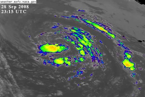
Large circulation.
ATL LAURA: Tropical Storm - Discussion
Moderator: S2k Moderators
- cycloneye
- Admin

- Posts: 139409
- Age: 67
- Joined: Thu Oct 10, 2002 10:54 am
- Location: San Juan, Puerto Rico
Re: ATL: INVEST 95L : Discussion
Floater 2:
Convection trying to wrap a little more closer to low center.


Convection trying to wrap a little more closer to low center.


0 likes
- TheEuropean
- Professional-Met

- Posts: 1793
- Age: 58
- Joined: Tue Sep 20, 2005 3:17 pm
- Location: Voerde, Germany
- Contact:
- MGC
- S2K Supporter

- Posts: 5795
- Joined: Sun Mar 23, 2003 9:05 pm
- Location: Pass Christian MS, or what is left.
Re: ATL: INVEST 95L : Discussion
Yea, huge circulation...just needs a bit more convection near the center.....MGC
0 likes
- Just Joshing You
- Category 2

- Posts: 512
- Joined: Sat Nov 03, 2007 10:29 am
- Location: Nova Scotia
- Matt-hurricanewatcher
- Category 5

- Posts: 11649
- Age: 38
- Joined: Fri Nov 26, 2004 11:09 pm
- Location: Portland,OR
- Contact:
Re: ATL: INVEST 95L : Discussion
Looks like a subtropical storm to me...We will see what the nhc does.
0 likes
- Just Joshing You
- Category 2

- Posts: 512
- Joined: Sat Nov 03, 2007 10:29 am
- Location: Nova Scotia
Re: ATL: INVEST 95L : Discussion
Matt-hurricanewatcher wrote:Looks like a subtropical storm to me...We will see what the nhc does.
Just like 94l looked like a tropical storm?
0 likes
- Matt-hurricanewatcher
- Category 5

- Posts: 11649
- Age: 38
- Joined: Fri Nov 26, 2004 11:09 pm
- Location: Portland,OR
- Contact:
Re: ATL: INVEST 95L : Discussion
Just Joshing You wrote:Matt-hurricanewatcher wrote:Looks like a subtropical storm to me...We will see what the nhc does.
Just like 94l looked like a tropical storm?
94L had everything a tropical storm has. 1# Warm core 2# developing convection near its center. So please think outside the box. This is also develop convection but in a more subtropical way. Also it has 2.5 st=subtroical. I don't expect the nhc will upgrade intill they are sure that it is.
0 likes
- Just Joshing You
- Category 2

- Posts: 512
- Joined: Sat Nov 03, 2007 10:29 am
- Location: Nova Scotia
- Matt-hurricanewatcher
- Category 5

- Posts: 11649
- Age: 38
- Joined: Fri Nov 26, 2004 11:09 pm
- Location: Portland,OR
- Contact:
Re: ATL: INVEST 95L : Discussion
A tropical cyclone supposed to have its strongest warm "core" near the surface. In 7c is more then enough to go tropical. Please show me the data to says other wise. I welcome you to show me it.
As for this it looks like most subtropical cyclones, I've seen, with a area of deep convection to one side wraping into the system.
As for this it looks like most subtropical cyclones, I've seen, with a area of deep convection to one side wraping into the system.
0 likes
- cycloneye
- Admin

- Posts: 139409
- Age: 67
- Joined: Thu Oct 10, 2002 10:54 am
- Location: San Juan, Puerto Rico
Re: ATL: INVEST 95L : Discussion
ABNT20 KNHC 282359
TWOAT
TROPICAL WEATHER OUTLOOK
NWS TPC/NATIONAL HURRICANE CENTER MIAMI FL
800 PM EDT SUN SEP 28 2008
FOR THE NORTH ATLANTIC...CARIBBEAN SEA AND THE GULF OF MEXICO...
THE NATIONAL HURRICANE CENTER IS ISSUING ADVISORIES ON HURRICANE
KYLE...LOCATED NEAR THE WESTERN TIP OF NOVA SCOTIA CANADA.
SHOWERS AND THUNDERSTORMS HAVE BECOME A LITTLE MORE CONCENTRATED
NEAR THE CENTER OF A LARGE NON-TROPICAL LOW PRESSURE AREA LOCATED
OVER THE CENTRAL NORTH ATLANTIC OCEAN ABOUT 800 MILES
WEST-SOUTHWEST OF THE WESTERNMOST AZORES ISLANDS. THIS SYSTEM
APPEARS TO BE SLOWLY ACQUIRING TROPICAL CHARACTERISTICS AND IT HAS
THE POTENTIAL TO BECOME A SUBTROPICAL OR TROPICAL CYCLONE DURING
THE NEXT COUPLE OF DAYS AS IT MOVES GENERALLY WEST OR
WEST-NORTHWESTWARD AT 10 TO 15 MPH.
ELSEWHERE...TROPICAL CYCLONE FORMATION IS NOT EXPECTED DURING THE
NEXT 48 HOURS.
$$
FORECASTER BROWN
0 likes
- cycloneye
- Admin

- Posts: 139409
- Age: 67
- Joined: Thu Oct 10, 2002 10:54 am
- Location: San Juan, Puerto Rico
Re: ATL: INVEST 95L : Discussion
Excuse me please,I think this is a thread for invest 95L,not for a past invest.If you want to debate about another invest,you can exchange PMS,but lets have this thread clear from that.
0 likes
- cycloneye
- Admin

- Posts: 139409
- Age: 67
- Joined: Thu Oct 10, 2002 10:54 am
- Location: San Juan, Puerto Rico
Re: ATL: INVEST 95L : Discussion
00:00 UTC Best Track still considers 95L as Non-Tropical.
AL, 95, 2008092900, , BEST, 0, 367N, 457W, 50, 995, EX,
ftp://ftp.tpc.ncep.noaa.gov/atcf/tcweb/
AL, 95, 2008092900, , BEST, 0, 367N, 457W, 50, 995, EX,
ftp://ftp.tpc.ncep.noaa.gov/atcf/tcweb/
0 likes
- El Nino
- Category 1

- Posts: 454
- Age: 46
- Joined: Sun Oct 16, 2005 3:18 pm
- Location: Lima - Miraflores (Peru)
- Contact:
Re: ATL: INVEST 95L : Discussion
50 kts. That's a strong "extra-tropical supposed to be (sub)tropical" storm !
0 likes
- Matt-hurricanewatcher
- Category 5

- Posts: 11649
- Age: 38
- Joined: Fri Nov 26, 2004 11:09 pm
- Location: Portland,OR
- Contact:
Re: ATL: INVEST 95L : Discussion
If convection can hold over the center, and quickscat can show that the wind field is growing more defined/tighter. Then maybe within the next 6-12 hours this could become a subtropical storm.
0 likes
- Matt-hurricanewatcher
- Category 5

- Posts: 11649
- Age: 38
- Joined: Fri Nov 26, 2004 11:09 pm
- Location: Portland,OR
- Contact:
Re: ATL: INVEST 95L : Discussion
Convection is over the southern part of the center...As far as I'm concerned this don't look to bad, well on its way.
0 likes
Who is online
Users browsing this forum: No registered users and 6 guests


