Ex Invest 90L
Moderator: S2k Moderators

-
Blown Away

- S2K Supporter

- Posts: 9867
- Joined: Wed May 26, 2004 6:17 am
Re: ATL: Invest 90L SW of Cape Verde Islands
If 90L develops I don't see how it will miss the Caribbean. This has a high potential to be a player.
0 likes


Re:
90 should do the "melon seed squirt", in which it runs out ahead of the SAL bearing down like a streamroller from the NE. This will keep it on a fast, straight westerly heading, and, if the system doesn't become undercut, will be conducive to strengthening around 50W.KWT wrote:Yeah shear doesn't look all that much a problem for this system, the only issue may be that fairly large SAL outbreak to the NE of the system, I think it will probably start to mix with this system in 24-36hrs time if it carries on at its current speed.
The Caribbean westerly sheer is dying down and the UL to the NW of 99L has filled in this morning, so that system will continues advancing west as well (meaning the two storms won't bunch up and interfere with each other).
This week is going to be very interesting.
0 likes
I agree though its hard to know Honeyko the SAL is much closer to the system then it was yesterday but it should start to weaken as it gets further west (the SAL I mean)
As you say this week will be interesting, I wouldn't be all that surprised to see this gaining some latitude once past 50W as the ridge is weaker to the north aroudn that latitude, however it probably won't make all that much of a difference.
The key uncertainty is going to be 99L track, if it does strengthen and 90L does as well then there will likely be some sort of weakness for this to head towards but will it be enough to take it away from its westerly course...
All big questions!
0 likes

-
Ed Mahmoud
Re: ATL: Invest 90L SW of Cape Verde Islands
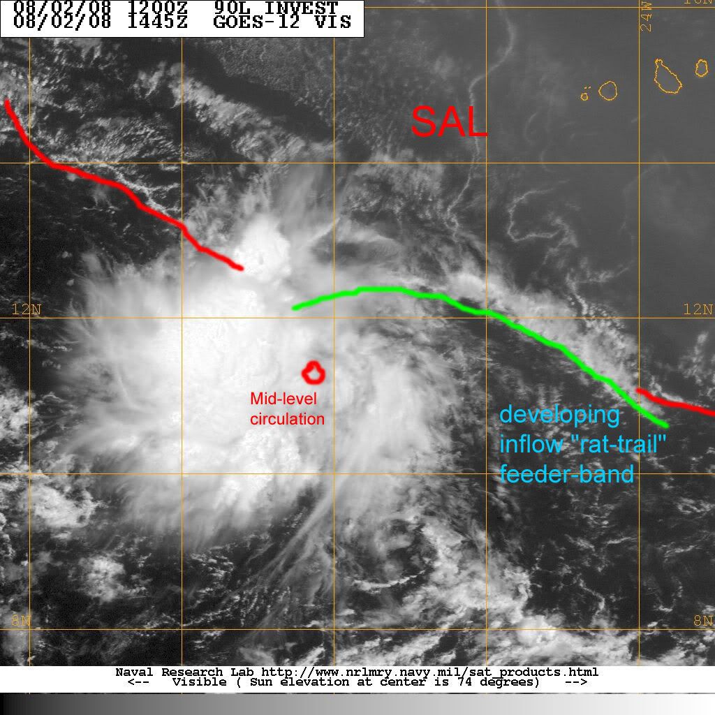
I see West to East low cloud motion crossing longitude lines on fuzzy, jumpy, poor quality NRL zoomed visible loop.
It may or may not be at surface, but I think it is close, closer than 99L, to having a closed circulation.
It may or may not be at surface, but I think it is close, closer than 99L, to having a closed circulation.
0 likes
-
Ed Mahmoud
Re:
KWT wrote:Its hard to say Ed because we don't know if thats at the surface, theres very likely a decent MLC developing and I'd have thought given there isn't much in the way of development the MLC will probably work its way down eventually.
They appear to be low cloud elements, but the NRL loops leave something to be desired.
0 likes
-
Gustywind

- Category 5

- Posts: 12334
- Joined: Mon Sep 03, 2007 7:29 am
- Location: Baie-Mahault, GUADELOUPE
A few disturbed areas, but nothing imminent
Lead Meteorologist, The Weather Channel
8:55 a.m. ET 8/2/2008
http://www.weather.com/newscenter/tropical/
Another area of unsettled weather is located about 250 miles southwest of the Cape Verde Islands in the far eastern Atlantic. There's a chance this system, too, could develop further over the next few days as it chugs westward at about 15 mph.
0 likes

Re: ATL: Invest 90L SW of Cape Verde Islands
ok of the two systems...90 L has me slightly more concerned because of the low latitude. However it still has plenty of shear to deal with. We should know more after it tracks over the warmer waters in the next couple of days. By then it should be about 3 days away from the islands and we could have a clearer view of the synoptics. I plan on going away to Ft. Myers beach and checking in every so often. I hope I am not in for any surprises when I return to South Florida in a week. Better get my water and batteries anyway (I know folks, I should have it already...I'm going I'm going) 
I didn't mean shear by the way I meant the SAL....I am not awake yet...sorry
I didn't mean shear by the way I meant the SAL....I am not awake yet...sorry
Last edited by wzrgirl1 on Sat Aug 02, 2008 12:13 pm, edited 1 time in total.
0 likes
-
'CaneFreak

- Category 5
- Posts: 1475
- Joined: Mon Jun 05, 2006 10:50 am
- Location: New Bern, NC
Re: ATL: Invest 90L SW of Cape Verde Islands
wzrgirl1 wrote:ok of the two systems...90 L has me slightly more concerned because of the low latitude. However it still has plenty of shear to deal with. We should know more after it tracks over the warmer waters in the next couple of days. By then it should be about 3 days away from the islands and we could have a clearer view of the synoptics. I plan on going away to Ft. Myers beach and checking in every so often. I hope I am not in for any surprises when I return to South Florida in a week. Better get my water and batteries anyway (I know folks, I should have it already...I'm going I'm going)
What shear?
0 likes
-
stevetampa33614
-
'CaneFreak
- Category 5
- Posts: 1475
- Joined: Mon Jun 05, 2006 10:50 am
- Location: New Bern, NC
Re: ATL: Invest 90L SW of Cape Verde Islands
stevetampa33614 wrote:There is no shear. And the SAL isnt an issue
Exactly and as you said earlier it has broken away from the ITCZ. It has excellent outflow due to a weak anticyclone over it and the list could go on and on. It looks like an egg on the frying pan on IR and that is what you want to see. Oh and btw, don't look at the SHIPS forecast for shear. It has been wrong more than it has been right this year.
0 likes
-
GeneratorPower

- S2K Supporter
- Posts: 1648
- Age: 44
- Joined: Sun Dec 18, 2005 11:48 pm
- Location: Huntsville, AL
Notice the nice moisture envelope around it on WV below. Much better than 99L.
http://www.ssd.noaa.gov/goes/east/catl/loop-wv.html
http://www.ssd.noaa.gov/goes/east/catl/loop-wv.html
0 likes
Who is online
Users browsing this forum: No registered users and 4 guests