ATL INVEST 94L: Discussion

Moderator: S2k Moderators

Message
Author
User avatar
Matt-hurricanewatcher
Category 5
Category 5
Posts: 11649
Age: 38
Joined: Fri Nov 26, 2004 11:09 pm
Location: Portland,OR
Contact:

Re:

#41 Postby Matt-hurricanewatcher » Wed Sep 24, 2008 9:17 am

HURAKAN wrote:Image

After Ike people have disappeared like the season is over. This system may bring them back!


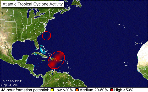
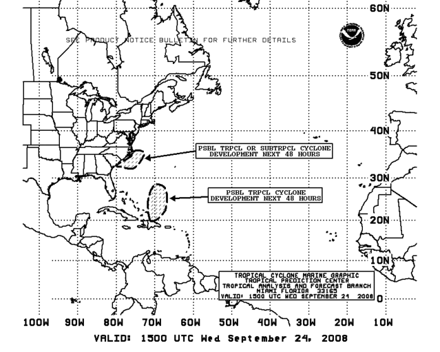
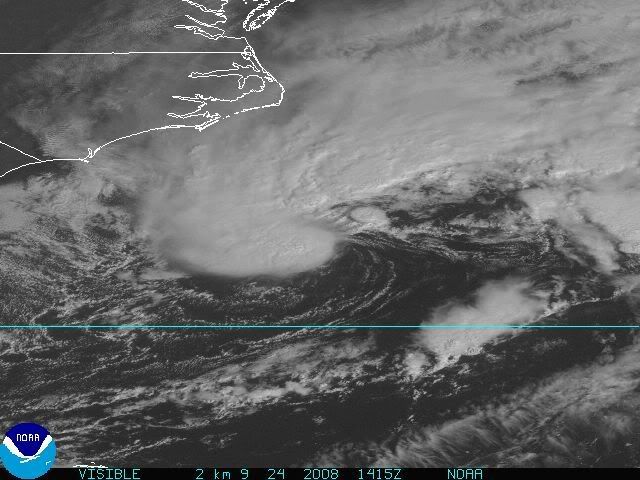
As the front detachest it appears that this is clearly becoming tropical. I think it should be kyle very soon indeed.
0 likes   

Frank2
Category 5
Category 5
Posts: 4061
Joined: Mon Jul 25, 2005 12:47 pm

#42 Postby Frank2 » Wed Sep 24, 2008 9:22 am

It seems 94L will be Kyle, but, 93L is about gone, fortunately...

http://www.goes.noaa.gov/browsh.html
0 likes   

User avatar
AJC3
Admin
Admin
Posts: 3878
Age: 60
Joined: Tue Aug 31, 2004 7:04 pm
Location: West Melbourne, Florida
Contact:

Re: ATL: INVEST 94L: Discussion

#43 Postby AJC3 » Wed Sep 24, 2008 9:23 am

vacanechaser wrote: however, the low is seperating itself from the front.... the map above shows the low along the front but the when looking at a close up sat loop, you can see where the front is now east of that low and the low drifting soutwestward... as long as the low seperates from the front like we are seeing now, i think this could become at least a sub-tropical system lter today


Jesse V. Bass III
http://www.vastormphoto.com
Hurricane Intercept Research Team


Preaching to the choir, Jesse. I pretty much made those points in my earlier post. All I said in my reply to Justin was that the ST designation as of 12Z simply referred to the technique used, and that HPC was still analyzing the cyclone as frontal at that time.
0 likes   

User avatar
wxman57
Moderator-Pro Met
Moderator-Pro Met
Posts: 22505
Age: 66
Joined: Sat Jun 21, 2003 8:06 pm
Location: Houston, TX (southwest)

Re: INVEST 94L: Special Tropical Disturbance Statement

#44 Postby wxman57 » Wed Sep 24, 2008 9:33 am

Based on their statement, the NHC will wait for recon before doing anything. I guess if recon couldn't get out there, they couldn't upgrade it to STS Kyle.
0 likes   

User avatar
BensonTCwatcher
Category 5
Category 5
Posts: 1046
Joined: Sat Aug 28, 2004 10:11 pm
Location: Southport NC

#45 Postby BensonTCwatcher » Wed Sep 24, 2008 9:33 am

I don't think this will get, nor will it need moisture/energy from 93L (not to disagree too much with Dr. Masters) especially with 93L stuck where it is or drifting WSW or some such direction. Apparently this is aquiring tropical characteristics a little faster than "later today"
0 likes   

User avatar
vacanechaser
Category 5
Category 5
Posts: 1461
Joined: Wed Dec 03, 2003 9:34 pm
Location: Portsmouth, Va
Contact:

Re: ATL: INVEST 94L: Discussion

#46 Postby vacanechaser » Wed Sep 24, 2008 9:34 am

AJC3 wrote:
vacanechaser wrote: however, the low is seperating itself from the front.... the map above shows the low along the front but the when looking at a close up sat loop, you can see where the front is now east of that low and the low drifting soutwestward... as long as the low seperates from the front like we are seeing now, i think this could become at least a sub-tropical system lter today


Jesse V. Bass III
http://www.vastormphoto.com
Hurricane Intercept Research Team


Preaching to the choir, Jesse. I pretty much made those points in my earlier post. All I said in my reply to Justin was that the ST designation as of 12Z simply referred to the technique used, and that HPC was still analyzing the cyclone as frontal at that time.


10-4... was not calling you out or anything... just an ob... looks like this thing is starting to take off... trying to decide where to head... the outer banks today looks good.. talking about overwash on hw 12... from there, i guess head south... still trying to feel it out... lol


Jesse V. Bass III
http://www.vastormphoto.com
Hurricane Intercept Research Team
0 likes   

User avatar
hurricanefloyd5
Category 5
Category 5
Posts: 1659
Age: 43
Joined: Sun May 02, 2004 10:53 am
Location: Spartanburg
Contact:

Re: INVEST 94L: Special Tropical Disturbance Statement

#47 Postby hurricanefloyd5 » Wed Sep 24, 2008 9:34 am

Think a Special ADV. will go out for what will be Kyle????????
0 likes   

User avatar
Matt-hurricanewatcher
Category 5
Category 5
Posts: 11649
Age: 38
Joined: Fri Nov 26, 2004 11:09 pm
Location: Portland,OR
Contact:

Re: INVEST 94L: Special Tropical Disturbance Statement

#48 Postby Matt-hurricanewatcher » Wed Sep 24, 2008 9:36 am

wxman57 wrote:Based on their statement, the NHC will wait for recon before doing anything. I guess if recon couldn't get out there, they couldn't upgrade it to STS Kyle.


So they would not upgrade with out recon if this plain as day detached from any "front", formed minus 80 convection, and then started to strengthen. It is slowly going in this direction...In I think if it can move away from this "front" dieing one at that, then it should be upgraded.
0 likes   

jinftl
Category 5
Category 5
Posts: 4312
Joined: Tue Aug 31, 2004 4:47 pm
Location: fort lauderdale, fl

Re: INVEST 94L: Special Tropical Disturbance Statement

#49 Postby jinftl » Wed Sep 24, 2008 9:36 am

SPECIAL TROPICAL DISTURBANCE STATEMENT
NWS TPC/NATIONAL HURRICANE CENTER MIAMI FL
1000 AM EDT WED SEP 24 2008

SATELLITE IMAGES INDICATE THAT THE LOW PRESSURE SYSTEM CENTERED
ABOUT 250 MILES...400 KM...SOUTHEAST OF WILMINGTON NORTH CAROLINA
IS ACQUIRING SOME TROPICAL CHARACTERISTICS. THIS SYSTEM COULD
BECOME A TROPICAL OR SUBTROPICAL CYCLONE LATER TODAY OR TONIGHT AS
IT MOVES WESTWARD OR WEST-NORTHWESTWARD. THE LOW IS ACCOMPANIED BY
WINDS OF UP TO 65 MPH...100 KM/HR...TO THE NORTH AND NORTHWEST OF
THE CENTER. REGARDLESS OF DEVELOPMENT THIS SYSTEM WILL BRING
STRONG WINDS...COASTAL FLOODING...HIGH SURF...AND DANGEROUS RIP
CURRENTS TO PORTIONS OF THE U.S. EAST COAST DURING THE NEXT COUPLE
OF DAYS. SEE STATEMENTS FROM LOCAL NATIONAL WEATHER SERVICE
FORECAST OFFICES FOR ADDITIONAL INFORMATION AND WARNINGS. AN AIR
FORCE HURRICANE HUNTER AIRCRAFT IS SCHEDULED TO INVESTIGATE THE
SYSTEM THIS AFTERNOON.

$$
FORECASTER PASCH/BERG


hurricanefloyd5 wrote:Think a Special ADV. will go out for what will be Kyle????????
0 likes   

User avatar
expat2carib
S2K Supporter
S2K Supporter
Posts: 458
Joined: Tue Jul 22, 2008 1:44 pm
Location: Sint Maarten

Re: INVEST 94L: Special Tropical Disturbance Statement

#50 Postby expat2carib » Wed Sep 24, 2008 9:36 am

I think wxman57 was right in the 93L discussion some days ago

wxman57 wrote:Sure do have to go on 24/7 coverage for this system if it develops. I think it may merge with the predicted storm center along the Mid Atlantic Coast late this week. Could be impacting our east coast clients.


viewtopic.php?f=59&t=103291&st=0&sk=t&sd=a&start=280
0 likes   

User avatar
BensonTCwatcher
Category 5
Category 5
Posts: 1046
Joined: Sat Aug 28, 2004 10:11 pm
Location: Southport NC

#51 Postby BensonTCwatcher » Wed Sep 24, 2008 9:37 am

Winds increasing from NE as forecast. expecting up to 50 mph at coast, and well incland due to gradient with H. We have seen setups like this prduce some nasty storms at the coast regardless of classification. Usually they are a bit later in the year. Although all season long it has looked more like a fall set up across the conus and carrib.
0 likes   

User avatar
AJC3
Admin
Admin
Posts: 3878
Age: 60
Joined: Tue Aug 31, 2004 7:04 pm
Location: West Melbourne, Florida
Contact:

Re: ATL: INVEST 94L: Discussion

#52 Postby AJC3 » Wed Sep 24, 2008 9:46 am

vacanechaser wrote: 10-4... was not calling you out or anything... just an ob... looks like this thing is starting to take off... trying to decide where to head... the outer banks today looks good.. talking about overwash on hw 12... from there, i guess head south... still trying to feel it out... lol


Jesse V. Bass III
http://www.vastormphoto.com
Hurricane Intercept Research Team


Yeah, this is one of those ugly situations where, even before the XT low started to form, you pretty much had gale force (or nearly so) winds yesterday due to the tight pgrad between the large high over the northeast U.S. and the weak trough/front offshore. From a forecaster perspective, it becomes a pretty much impossible to discern where the winds associated with the low itself are on the north side of the system versus the pre-existing gradient flow to the north. And when/if the cyclone winds up transitioning from an XTC to a STC to a TC, you often wind up having gale warnings next to TC warnings. IIRC just last year with Noel we had gale warning in place along the east central FL coast due to a tight pgrad associated with a strong high to our north, and wound up with TS warnings for southeast FL and the Bahamas, immediately adjacent to the gale warnings.
0 likes   

User avatar
HURAKAN
Professional-Met
Professional-Met
Posts: 46086
Age: 37
Joined: Thu May 20, 2004 4:34 pm
Location: Key West, FL
Contact:

#53 Postby HURAKAN » Wed Sep 24, 2008 9:58 am

Image

Image
0 likes   

User avatar
HURAKAN
Professional-Met
Professional-Met
Posts: 46086
Age: 37
Joined: Thu May 20, 2004 4:34 pm
Location: Key West, FL
Contact:

#54 Postby HURAKAN » Wed Sep 24, 2008 10:10 am

0 likes   

User avatar
HURAKAN
Professional-Met
Professional-Met
Posts: 46086
Age: 37
Joined: Thu May 20, 2004 4:34 pm
Location: Key West, FL
Contact:

#55 Postby HURAKAN » Wed Sep 24, 2008 10:18 am

Image

Microwave Image.
0 likes   

User avatar
Evil Jeremy
S2K Supporter
S2K Supporter
Posts: 5459
Age: 31
Joined: Mon Apr 10, 2006 2:10 pm
Location: Los Angeles, CA

Re: ATL INVEST 94L: Discussion - Code Red

#56 Postby Evil Jeremy » Wed Sep 24, 2008 10:26 am

Could this system break the record time from Invest to Cyclone that was set by Humberto (I think)? I have also never seen a subtropical hurricane before, could that happen?
0 likes   

User avatar
hurricanedude
Military Member
Military Member
Posts: 1856
Joined: Tue Oct 08, 2002 9:54 am
Location: Virginia Beach, Virginia
Contact:

Re: ATL INVEST 94L: Discussion - Code Red

#57 Postby hurricanedude » Wed Sep 24, 2008 10:28 am

no such thing as subtropical hurricane....HURRICANE means purely tropical!
0 likes   

Cryomaniac
Category 5
Category 5
Posts: 1289
Joined: Tue Aug 15, 2006 2:26 pm
Location: Newark, Nottinghamshire, UK
Contact:

#58 Postby Cryomaniac » Wed Sep 24, 2008 10:30 am

^ So a Subtropical storm with 85kt winds would still be called a Subtropical storm?
0 likes   

User avatar
Evil Jeremy
S2K Supporter
S2K Supporter
Posts: 5459
Age: 31
Joined: Mon Apr 10, 2006 2:10 pm
Location: Los Angeles, CA

Re: ATL INVEST 94L: Discussion - Code Red

#59 Postby Evil Jeremy » Wed Sep 24, 2008 10:31 am

hurricanedude wrote:no such thing as subtropical hurricane....HURRICANE means purely tropical!

Oh, in that case, has there ben a subtropical storm with Hurricane winds since they started naming them?
0 likes   

User avatar
Hurricaneman
Category 5
Category 5
Posts: 7284
Age: 43
Joined: Tue Aug 31, 2004 3:24 pm
Location: central florida

Re:

#60 Postby Hurricaneman » Wed Sep 24, 2008 10:32 am

Cryomaniac wrote:^ So a Subtropical storm with 85kt winds would still be called a Subtropical storm?


yep because it isn't purely tropical
0 likes   


Return to “2008”

Who is online

Users browsing this forum: No registered users and 8 guests