ATL INVEST 94L: Discussion

Moderator: S2k Moderators

Message
Author
CrazyC83
Professional-Met
Professional-Met
Posts: 33398
Joined: Tue Mar 07, 2006 11:57 pm
Location: Deep South, for the first time!

Re: ATL INVEST 94L: Discussion - Code Red

#61 Postby CrazyC83 » Wed Sep 24, 2008 10:32 am

Evil Jeremy wrote:
hurricanedude wrote:no such thing as subtropical hurricane....HURRICANE means purely tropical!

Oh, in that case, has there ben a subtropical storm with Hurricane winds since they started naming them?


No there hasn't.

I would create a term "subtropical hurricane" though for storms with 65 kt or more that are subtropical though.
0 likes   

User avatar
hurricanedude
Military Member
Military Member
Posts: 1856
Joined: Tue Oct 08, 2002 9:54 am
Location: Virginia Beach, Virginia
Contact:

Re: ATL INVEST 94L: Discussion - Code Red

#62 Postby hurricanedude » Wed Sep 24, 2008 10:33 am

sts with hurricane force winds would still be a sts....HURRICANE IMPLIES TOTAL TROPICAL.
Hurricane force wind warning would be needed...hurricane force wind warning and a Hurricane warning are different
0 likes   

User avatar
Matt-hurricanewatcher
Category 5
Category 5
Posts: 11649
Age: 38
Joined: Fri Nov 26, 2004 11:09 pm
Location: Portland,OR
Contact:

Re: ATL INVEST 94L: Discussion - Code Red

#63 Postby Matt-hurricanewatcher » Wed Sep 24, 2008 10:33 am

Personal Forecast Disclaimer:
The posts in this forum are NOT official forecast and should not be used as such. They are just the opinion of the poster and may or may not be backed by sound meteorological data. They are NOT endorsed by any professional institution or storm2k.org. For official information, please refer to the NHC and NWS products.

Some thinking

Quickscat has some 45-50 knot flags to the northwest of the center of the cirulation as of 11z this morning. With 30-35 knot winds moving ashore over the outterbanks. Quickscat and visible shows LLC developing near 31.5/75.1 or on the eastern side of the convection. Convection has clearly developed over the LLC, and the frontal system has detached from the cyclone. Sab t shows st2.5, with my thinking of t is 3.2. Winds are put at 50 knots.

This front is forecasted to weaken and move away from the cyclone. The LLC is moving south-southwestward over the last 6 hours...It is forecasted to turn more westward as the ridge to the northwest of the system moves north of it within the next 24-36 hours. Models forecast this system to make landfall within the next 36-48 hours over SC/NC. Wind shear has decreased by 20-30 knots over the last 24 hours...In the upper level environment is expected to become favorable for more development. I'm expecting this system to develop to 60-65 knots by landfall, so a hurricane is possible.

Wind forecast
0 50 knots
6 55 knots
12 60 knots
24 60 knots
36 65 knots
48 50 knots inland
0 likes   

User avatar
hurricanedude
Military Member
Military Member
Posts: 1856
Joined: Tue Oct 08, 2002 9:54 am
Location: Virginia Beach, Virginia
Contact:

Re: ATL INVEST 94L: Discussion - Code Red

#64 Postby hurricanedude » Wed Sep 24, 2008 10:37 am

I think a hurricane is likely....at the very least...hurricane gusts.....75-85mph for the NC,VA,MD coasts....
0 likes   

User avatar
wxman57
Moderator-Pro Met
Moderator-Pro Met
Posts: 22505
Age: 66
Joined: Sat Jun 21, 2003 8:06 pm
Location: Houston, TX (southwest)

Re: ATL INVEST 94L: Discussion - Code Red

#65 Postby wxman57 » Wed Sep 24, 2008 10:44 am

Convection is clearly dropping off now. Looked a lot more impressive 2 hours ago. The cool and very dry air (dew points upper 40s to low 50s) that exists from SC to NY is flowing into the low now. This should keep it from becoming tropical. Still, I don't know what other evidence the NHC needs to name it STS Kyle.
0 likes   

Ed Mahmoud

Re: ATL INVEST 94L: Discussion - Code Red

#66 Postby Ed Mahmoud » Wed Sep 24, 2008 11:00 am

IIRC, once an STS has hurricane force winds, they call it, simply, a hurricane, even if it isn't purely tropical. I think it is simply a matter of minimizing confusion.
0 likes   

User avatar
MGC
S2K Supporter
S2K Supporter
Posts: 5796
Joined: Sun Mar 23, 2003 9:05 pm
Location: Pass Christian MS, or what is left.

Re: ATL INVEST 94L: Discussion - Code Red

#67 Postby MGC » Wed Sep 24, 2008 11:07 am

Looks like convection is becoming a bit more concentrated near the circulation center. Good chance 94L will become a TS or STS soon. Should feed off the Gulf Stream....MGC
0 likes   

Myersgirl
Tropical Storm
Tropical Storm
Posts: 216
Joined: Fri Jul 23, 2004 7:32 pm
Location: Fort Myers
Contact:

Re: ATL INVEST 94L: Discussion - Code Red

#68 Postby Myersgirl » Wed Sep 24, 2008 11:07 am

The Neptune Festival on Virginia Beach boardwalk starts Friday, do you think the winds will still be high? I am scheduled to participate but am now thinking it is not a good idea to be in a tent on the boardwalk with my art this weekend. Not to mention driving there tomorrow up I-95. Anybody from the area? Advice?
0 likes   

User avatar
Chacor
Category 5
Category 5
Posts: 10229
Joined: Mon Oct 02, 2006 10:43 pm
Location: Singapore

Re: ATL INVEST 94L: Discussion - Code Red

#69 Postby Chacor » Wed Sep 24, 2008 11:08 am

Ed Mahmoud wrote:IIRC, once an STS has hurricane force winds, they call it, simply, a hurricane, even if it isn't purely tropical. I think it is simply a matter of minimizing confusion.


Actually, no. As long as it's subtropical they will continue to call it an STS.
0 likes   

User avatar
HURAKAN
Professional-Met
Professional-Met
Posts: 46086
Age: 37
Joined: Thu May 20, 2004 4:34 pm
Location: Key West, FL
Contact:

#70 Postby HURAKAN » Wed Sep 24, 2008 11:09 am

Image

Image
0 likes   

User avatar
wxman57
Moderator-Pro Met
Moderator-Pro Met
Posts: 22505
Age: 66
Joined: Sat Jun 21, 2003 8:06 pm
Location: Houston, TX (southwest)

Re: ATL INVEST 94L: Discussion - Code Red

#71 Postby wxman57 » Wed Sep 24, 2008 11:10 am

Moisture from 93L is already flowing into 94L, as can be seen here:

Image
0 likes   

Ed Mahmoud

Re: ATL INVEST 94L: Discussion - Code Red

#72 Postby Ed Mahmoud » Wed Sep 24, 2008 11:13 am

Chacor wrote:
Ed Mahmoud wrote:IIRC, once an STS has hurricane force winds, they call it, simply, a hurricane, even if it isn't purely tropical. I think it is simply a matter of minimizing confusion.


Actually, no. As long as it's subtropical they will continue to call it an STS.


I was looking at the Nat'l Hurricane Operations Plan, and couldn't find a clear answer. However, the FAQ is somewhat interesting...

Subject: A6) What is a sub-tropical cyclone?
Contributed by Chris Landsea


A sub-tropical cyclone is a low-pressure system existing in the tropical or subtropical latitudes (anywhere from the equator to about 50°N) that has characteristics of both tropical cyclones and mid-latitude (or extratropical) cyclones. Therefore, many of these cyclones exist in a weak to moderate horizontal temperature gradient region (like mid-latitude cyclones), but also receive much of their energy from convective clouds (like tropical cyclones). Often, these storms have a radius of maximum winds which is farther out (on the order of 100-200 km [60-125 miles] from the center) than what is observed for purely "tropical" systems. Additionally, the maximum sustained winds for sub-tropical cyclones have not been observed to be stronger than about 33 m/s (64 kts, 74 mph)).
Many times these subtropical storms transform into true tropical cyclones. A recent example is the Atlantic basin's Hurricane Florence in November 1994 which began as a subtropical cyclone before becoming fully tropical. Note there has been at least one occurrence of tropical cyclones transforming into a subtropical storm (e.g. Atlantic basin storm 8 in 1973).

Subtropical cyclones in the Atlantic basin are classified by the maximum sustained surface winds:

less than 18 m/s (34 kts, 39 mph) - "subtropical depression",
greater than or equal to 18 m/s (34 kts, 39 mph) - "subtropical storm"
Prior to 2002 subtropical storms were not given names, but the OAR issued forecasts and warnings similar to those for tropical cyclones. Now they are given names from the tropical cyclone list.


That bolded part leaves multiple interpretations, as to what happens when a sub-tropical system would develop winds greater than hurricane strength.
0 likes   

User avatar
Chacor
Category 5
Category 5
Posts: 10229
Joined: Mon Oct 02, 2006 10:43 pm
Location: Singapore

Re: ATL INVEST 94L: Discussion - Code Red

#73 Postby Chacor » Wed Sep 24, 2008 11:17 am

Ed Mahmoud wrote:I was looking at the Nat'l Hurricane Operations Plan, and couldn't find a clear answer. However, the FAQ is somewhat interesting...

Subject: A6) What is a sub-tropical cyclone?
Contributed by Chris Landsea


A sub-tropical cyclone is a low-pressure system existing in the tropical or subtropical latitudes (anywhere from the equator to about 50°N) that has characteristics of both tropical cyclones and mid-latitude (or extratropical) cyclones. Therefore, many of these cyclones exist in a weak to moderate horizontal temperature gradient region (like mid-latitude cyclones), but also receive much of their energy from convective clouds (like tropical cyclones). Often, these storms have a radius of maximum winds which is farther out (on the order of 100-200 km [60-125 miles] from the center) than what is observed for purely "tropical" systems. Additionally, the maximum sustained winds for sub-tropical cyclones have not been observed to be stronger than about 33 m/s (64 kts, 74 mph)).
Many times these subtropical storms transform into true tropical cyclones. A recent example is the Atlantic basin's Hurricane Florence in November 1994 which began as a subtropical cyclone before becoming fully tropical. Note there has been at least one occurrence of tropical cyclones transforming into a subtropical storm (e.g. Atlantic basin storm 8 in 1973).

Subtropical cyclones in the Atlantic basin are classified by the maximum sustained surface winds:

less than 18 m/s (34 kts, 39 mph) - "subtropical depression",
greater than or equal to 18 m/s (34 kts, 39 mph) - "subtropical storm"
Prior to 2002 subtropical storms were not given names, but the OAR issued forecasts and warnings similar to those for tropical cyclones. Now they are given names from the tropical cyclone list.


That bolded part leaves multiple interpretations, as to what happens when a sub-tropical system would develop winds greater than hurricane strength.


"greater than or equal to 18 m/s (34 kts, 39 mph) - "subtropical storm" " should answer it. >34 kts includes hurricane-force winds.
0 likes   

User avatar
Chacor
Category 5
Category 5
Posts: 10229
Joined: Mon Oct 02, 2006 10:43 pm
Location: Singapore

#74 Postby Chacor » Wed Sep 24, 2008 11:27 am

Also, on a final note about what its status would be:

Look at HURDAT. There are two hurricane-strength subtropical storms.

43770 09/14/1968 M=10 06 SNBR= 941 SUBTROP 1 XING=0
43775 09/14* 0 0 0 0* 0 0 0 0S315 730 20 1012S318 721 20 0*
43780 09/15S321 710 20 1009S325 698 25 0S330 685 25 1009S331 676 30 0*
43785 09/16S335 670 30 1006S348 676 35 0S360 680 40 1003S373 665 45 0*
43790 09/17S385 650 50 997S391 639 50 0S390 630 50 995S388 625 55 0*
43795 09/18S385 620 60 993S383 615 60 0S380 610 60 993S378 605 60 0*
43800 09/19S375 600 60 993S373 595 60 0S370 590 60 990S363 579 60 0*
43805 09/20S355 560 60 987S352 526 65 0S355 490 65 985S376 465 70 0*
43810 09/21S395 450 70 979S399 443 70 0S403 437 65 982S406 431 65 0*

43815 09/22S410 425 60 984S415 416 60 0S420 405 60 986S422 392 55 0*
43820 09/23S423 380 55 992S424 369 50 0E425 360 45 995E425 350 40 997*
43825 SS

49570 10/23/1979 M= 3 9 SNBR=1056 SUBTROP 1 XING=0 L
49575 10/23* 0 0 0 0* 0 0 0 0S290 660 25 1007S310 653 25 1004*
49580 10/24S330 648 30 1000S350 640 40 996S375 630 50 990S405 620 65 985*
49585 10/25S435 610 60 980S475 584 50 982S510 550 45 987* 0 0 0 0*
49590 SS
Last edited by Chacor on Wed Sep 24, 2008 11:28 am, edited 1 time in total.
0 likes   

User avatar
fci
S2K Supporter
S2K Supporter
Posts: 3297
Joined: Tue Sep 14, 2004 10:29 am
Location: Lake Worth, FL

Re: ATL: INVEST 94L: Discussion

#75 Postby fci » Wed Sep 24, 2008 11:28 am

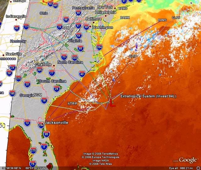
Ed Mahmoud wrote:JB was on the case a week ago...


Ed Mahmoud wrote:12Z GFS Loop

Per the JB video, old rule from the days before computer models that his father subscribed to - mid August to mid October, pressure reaches/exceeds 1025 mb at Cape Hatteras, look out to the South.

I guess because pressure that high over Hatteras implies strong East winds over the SE US and Bahamas, and the Florida landmass causes slowing/convergence.

GFS shows big time Northeast US high pressure, and then falling pressure, kind of in the shape of an inverted trough in the next week.


GFS also shows Cape Verde season trying to refire, although it seems to be getting less likely something can get all the way across to North America/the islands in late September.


PLEASE!!!!

Can we stop tossing out "shout outs" to JB when he does his job and suggests a system and it occurs?
ALL of the Pro Mets have "been on the case" now for over a week and they don't get posts put out there for purposes of them "taking bows".

I'm sorry but it is like clockwork.
JB predicts all kinds of systems and "some" do what he predicts, and some don't; and when it does happen there is always someone who has to post that "JB called it" or something like that.

I RESPECT JB and his company as I respect all Pro Mets so please do not take this as any "trashing' of Mr Bastardi.
It is, by all means; not to disparage him at all but it is to call out the "cheerleading".
0 likes   

capepoint
Category 1
Category 1
Posts: 414
Joined: Sat Jul 19, 2008 7:13 pm
Location: Beaufort, NC

Re: ATL: INVEST 94L: Discussion

#76 Postby capepoint » Wed Sep 24, 2008 11:29 am

vacanechaser wrote:
AJC3 wrote:
vacanechaser wrote: however, the low is seperating itself from the front.... the map above shows the low along the front but the when looking at a close up sat loop, you can see where the front is now east of that low and the low drifting soutwestward... as long as the low seperates from the front like we are seeing now, i think this could become at least a sub-tropical system lter today


Jesse V. Bass III
http://www.vastormphoto.com
Hurricane Intercept Research Team


Preaching to the choir, Jesse. I pretty much made those points in my earlier post. All I said in my reply to Justin was that the ST designation as of 12Z simply referred to the technique used, and that HPC was still analyzing the cyclone as frontal at that time.


10-4... was not calling you out or anything... just an ob... looks like this thing is starting to take off... trying to decide where to head... the outer banks today looks good.. talking about overwash on hw 12... from there, i guess head south... still trying to feel it out... lol


Jesse V. Bass III
http://www.vastormphoto.com
Hurricane Intercept Research Team


Hi Jesse, just thought I'd let you know, NC12 Cedar Island shallow overwash last night and today, tides on south side of Neuse river around Havelock are also 2-3 feet above normal. Soundside water is up about 1-2 feet in Morehead City.
Currently winds in Morehead City are about 25 gusting to 39 freqently, but they are NE so I dont know how much is 94 or the gradient. Overcast, no rain yet. If you decide to come down this way, would recommend the Sea Level, Atlantic, Cedar Island area for best conditions right now. Cedar Island near ferry would be best for you to get wind data but you might get stuck by high water on nc12. I understand that the water was in some yards nearing houses earlier. Keep safe.
0 likes   

Ed Mahmoud

Re: ATL INVEST 94L: Discussion - Code Red

#77 Postby Ed Mahmoud » Wed Sep 24, 2008 11:31 am

Chacor- you may indeed be right, but the AOML faq implies an STS never gets hurricane force winds.


If one did, issuing tropical storm warnings and hurricane force wind warnings for the same stretch of coast would seem confusing.
0 likes   

CrazyC83
Professional-Met
Professional-Met
Posts: 33398
Joined: Tue Mar 07, 2006 11:57 pm
Location: Deep South, for the first time!

Re:

#78 Postby CrazyC83 » Wed Sep 24, 2008 11:36 am

Chacor wrote:Also, on a final note about what its status would be:

Look at HURDAT. There are two hurricane-strength subtropical storms.

43770 09/14/1968 M=10 06 SNBR= 941 SUBTROP 1 XING=0
43775 09/14* 0 0 0 0* 0 0 0 0S315 730 20 1012S318 721 20 0*
43780 09/15S321 710 20 1009S325 698 25 0S330 685 25 1009S331 676 30 0*
43785 09/16S335 670 30 1006S348 676 35 0S360 680 40 1003S373 665 45 0*
43790 09/17S385 650 50 997S391 639 50 0S390 630 50 995S388 625 55 0*
43795 09/18S385 620 60 993S383 615 60 0S380 610 60 993S378 605 60 0*
43800 09/19S375 600 60 993S373 595 60 0S370 590 60 990S363 579 60 0*
43805 09/20S355 560 60 987S352 526 65 0S355 490 65 985S376 465 70 0*
43810 09/21S395 450 70 979S399 443 70 0S403 437 65 982S406 431 65 0*

43815 09/22S410 425 60 984S415 416 60 0S420 405 60 986S422 392 55 0*
43820 09/23S423 380 55 992S424 369 50 0E425 360 45 995E425 350 40 997*
43825 SS

49570 10/23/1979 M= 3 9 SNBR=1056 SUBTROP 1 XING=0 L
49575 10/23* 0 0 0 0* 0 0 0 0S290 660 25 1007S310 653 25 1004*
49580 10/24S330 648 30 1000S350 640 40 996S375 630 50 990S405 620 65 985*
49585 10/25S435 610 60 980S475 584 50 982S510 550 45 987* 0 0 0 0*
49590 SS


So that answers the question, although I knew that they would call it a "subtropical storm" officially. I've never seen it happen operationally though, so what they put in the advisories is anyone's guess.

Warnings are issued the same as for a tropical cyclone (precedence was Tropical Storm Watches and Warnings issued for Andrea, even though it was never forecast to become a tropical cyclone).
0 likes   

fasterdisaster
Category 5
Category 5
Posts: 1868
Joined: Mon Sep 19, 2005 4:41 pm
Location: Miami, Florida

Re: ATL INVEST 94L: Discussion - Code Red

#79 Postby fasterdisaster » Wed Sep 24, 2008 11:42 am

hurricanedude wrote:no such thing as subtropical hurricane....HURRICANE means purely tropical!


I'm pretty sure this is wrong. There hasn't been any STS recorded over 65 mph since when they started naming the STSs which gives the impression hurricanes can't be subtropical but I don't think that's true. A hurricane is a hurricane is a hurricane, and it's harder for STSs to become hurricanes but it is possible though pretty rare. They would call it Subtropical Hurricane Kyle I think.
0 likes   

User avatar
Chacor
Category 5
Category 5
Posts: 10229
Joined: Mon Oct 02, 2006 10:43 pm
Location: Singapore

#80 Postby Chacor » Wed Sep 24, 2008 11:46 am

There just isn't such a thing as a subtropical hurricane. A hurricane is a tropical cyclone. It's not difficult to comprehend. You don't see "SH" in HURDAT, you see "SS".
0 likes   


Return to “2008”

Who is online

Users browsing this forum: No registered users and 2 guests