ATL: Tropical Depression Dolly

Moderator: S2k Moderators

Message
Author
User avatar
cheezyWXguy
Category 5
Category 5
Posts: 5556
Joined: Mon Feb 13, 2006 12:29 am
Location: Dallas, TX

Re: ATL: INVEST 94L East of Windward Islands

#81 Postby cheezyWXguy » Sun Jul 13, 2008 10:22 am

Stratosphere747 wrote:
cheezyWXguy wrote:
Stratosphere747 wrote:

Then why mention the 'Hebert Box' in the models thread?

because, he was talking about the GFS, which brought a developed tropical cyclone into the Hebert box.


You missed my point. No worries....

Not to start an arguement or carry one on or something, but I do see your point. You think it is contradictory to say "its too early to talk about a US landfall" and then in another thread, talk about the Hebert Box. Correct me if Im wrong, but it seemed to me that he was only stating the possibility of it getting to the Hebert box, as shown by the GFS.
0 likes   

Aric Dunn
Category 5
Category 5
Posts: 21228
Age: 41
Joined: Sun Sep 19, 2004 9:58 pm
Location: Ready for the Chase.
Contact:

#82 Postby Aric Dunn » Sun Jul 13, 2008 10:25 am

we should see this thing go through some pretty rapid organization as it should lift slight wnw as it needs to break off from the itcz. i would say this time tomorrow we should be on the verge of a depression.. as it already has very good low level convergence and a clear surface circulation.. ( not closed yet, does not look like it, but a clear cyclonic circulation is present ).
0 likes   

User avatar
cycloneye
Admin
Admin
Posts: 139338
Age: 67
Joined: Thu Oct 10, 2002 10:54 am
Location: San Juan, Puerto Rico

Re: ATL: INVEST 94L East of Windward Islands

#83 Postby cycloneye » Sun Jul 13, 2008 10:32 am

Image
0 likes   

User avatar
Emmett_Brown
Category 5
Category 5
Posts: 1343
Joined: Wed Aug 24, 2005 9:10 pm
Location: Sarasota FL

Re: ATL: INVEST 94L East of Windward Islands

#84 Postby Emmett_Brown » Sun Jul 13, 2008 10:34 am

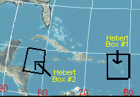
Help me out with the Hebert Box... I know that 20n, 60W is usually a benchmark for storms reaching Conus (those below this point have a better chance to affect Conus), but i dont know the dimensions of the "box". How big is this box, and what are it's N,S,E,W boudries?
0 likes   

RL3AO
Moderator-Pro Met
Moderator-Pro Met
Posts: 16308
Joined: Thu Jun 14, 2007 10:03 pm
Location: NC

Re: ATL: INVEST 94L East of Windward Islands

#85 Postby RL3AO » Sun Jul 13, 2008 10:37 am

Emmett_Brown wrote:Help me out with the Hebert Box... I know that 20n, 60W is usually a benchmark for storms reaching Conus (those below this point have a better chance to affect Conus), but i dont know the dimensions of the "box". How big is this box, and what are it's N,S,E,W boudries?


Theres two of them.

Image

And its not for CONUS, its for Florida.
0 likes   

User avatar
Blown Away
S2K Supporter
S2K Supporter
Posts: 9867
Joined: Wed May 26, 2004 6:17 am

Re: ATL: INVEST 94L East of Windward Islands

#86 Postby Blown Away » Sun Jul 13, 2008 10:39 am

IMO, 94L looks real good at this rate I wouldn't be surprised to see a TD by Monday.

http://www.ssd.noaa.gov/goes/flt/t2/loop-vis.html
Last edited by Blown Away on Sun Jul 13, 2008 10:47 am, edited 1 time in total.
0 likes   

RL3AO
Moderator-Pro Met
Moderator-Pro Met
Posts: 16308
Joined: Thu Jun 14, 2007 10:03 pm
Location: NC

#87 Postby RL3AO » Sun Jul 13, 2008 10:41 am

Just a note to add. Large and unorganized systems like this one usually take longer to organize.
0 likes   

User avatar
NDG
S2K Supporter
S2K Supporter
Posts: 14934
Joined: Sun Jul 09, 2006 10:14 pm
Location: Orlando, FL

Re: ATL: INVEST 94L East of Windward Islands

#88 Postby NDG » Sun Jul 13, 2008 10:42 am

Thunder44 wrote:
wxman57 wrote:Some things to keep in mind when looking at the model guidance.

1. The BAM models are not dynamic. They are a good indication of the CURRENT flow patterns (shallow, medium and deep) but they won't do well if the flow pattern is changing with time. So if a cold front is moving off the east U.S. coast in 6-7 days or if a trof is digging south toward the eastern Caribbean, the BAM models won't see it. They'll just keep moving this system westward in the CURRENT flow.

2. The ECMWF is pretty bad as a tropical model. Not as bad as the ETA/NAM/WRF, but it's not one to trust much

3. The GFS actually isn't too bad, but it does tend to break down the ridge to the north too quickly sometimes, indicating recurvature too soon. Didn't do too badly with Bertha, though.

4. HWRF and GFDL did pretty good with Bertha, indicating recurvature east of Bermuda before the other models.

We were talking about the pattern of development in the office on Friday possibly resembling 1995 in that we may have a big circle of storms in the Atlantic, some clipping the NE Caribbean before turning northward. We'll see.


IMO, the ECMWF, is more useful, after the TC has formed and when they become major storms too.


IMO, the ECM did not do that bad. Yes, it has a problem of being inconsistent with intensity of tropical cyclones, but it showed Bertha stalling out before the HWRF and GFDL ever showed a hint of it.
0 likes   

User avatar
kpost
Tropical Storm
Tropical Storm
Posts: 101
Age: 47
Joined: Sun Jul 06, 2008 10:52 am
Location: Indialantic, Florida (Ohio 4now)

Re: ATL: INVEST 94L East of Windward Islands

#89 Postby kpost » Sun Jul 13, 2008 10:44 am

i have a newbie question. If this develops, will it be as large as it is now or will it contract? it is huge compared to Bertha and if something like this hit land, like Florida, it looks like it would take up the whole state. well lets just hope it does nothing, my brother in law is worried because they will be here to visit in east central Florida on the 20th. they are also stopping in Charleston, SC first. so the NHC's map freaked him out.
0 likes   

User avatar
chadtm80
Category 5
Category 5
Posts: 20381
Age: 43
Joined: Tue Oct 08, 2002 8:35 am
Location: East Central Florida
Contact:

Re: ATL: INVEST 94L East of Windward Islands

#90 Postby chadtm80 » Sun Jul 13, 2008 10:45 am

Image
0 likes   

User avatar
cheezyWXguy
Category 5
Category 5
Posts: 5556
Joined: Mon Feb 13, 2006 12:29 am
Location: Dallas, TX

Re:

#91 Postby cheezyWXguy » Sun Jul 13, 2008 10:46 am

RL3AO wrote:Just a note to add. Large and unorganized systems like this one usually take longer to organize.

Its not really all that disorganized right now. To me, based on visible, there is obvious cyclonic turning, and there looks to be a very loose "CDO" type convection mass over the "center", wherever it may be. Also, I notice a couple of very primitive banding features trying to develop. Now, if the convection begins to consolidate and deepen, we may just have a td on our hands sometime tomorrow.
0 likes   

RL3AO
Moderator-Pro Met
Moderator-Pro Met
Posts: 16308
Joined: Thu Jun 14, 2007 10:03 pm
Location: NC

Re: Re:

#92 Postby RL3AO » Sun Jul 13, 2008 10:48 am

cheezyWXguy wrote:
RL3AO wrote:Just a note to add. Large and unorganized systems like this one usually take longer to organize.

Its not really all that disorganized right now. To me, based on visible, there is obvious cyclonic turning, and there looks to be a very loose "CDO" type convection mass over the "center", wherever it may be. Also, I notice a couple of very primitive banding features trying to develop. Now, if the convection begins to consolidate and deepen, we may just have a td on our hands sometime tomorrow.


Image

IMO, that is disorganized.
0 likes   

Aric Dunn
Category 5
Category 5
Posts: 21228
Age: 41
Joined: Sun Sep 19, 2004 9:58 pm
Location: Ready for the Chase.
Contact:

Re: Re:

#93 Postby Aric Dunn » Sun Jul 13, 2008 10:49 am

RL3AO wrote:
cheezyWXguy wrote:
RL3AO wrote:Just a note to add. Large and unorganized systems like this one usually take longer to organize.

Its not really all that disorganized right now. To me, based on visible, there is obvious cyclonic turning, and there looks to be a very loose "CDO" type convection mass over the "center", wherever it may be. Also, I notice a couple of very primitive banding features trying to develop. Now, if the convection begins to consolidate and deepen, we may just have a td on our hands sometime tomorrow.


Image

IMO, that is disorganized.


to what bertha of course.. but compared to a developing area of low pressure in the deep tropics .. its pretty good..
0 likes   

HurricaneHunter914
Category 5
Category 5
Posts: 4439
Age: 30
Joined: Fri Mar 10, 2006 7:36 pm
Location: College Station, TX

#94 Postby HurricaneHunter914 » Sun Jul 13, 2008 10:50 am

http://www.ssd.noaa.gov/goes/flt/t2/loop-vis.html
If you look at the visible loop, there are signs of cyclonic turning. It's a little disorganized now, but it's getting there.
0 likes   

Aric Dunn
Category 5
Category 5
Posts: 21228
Age: 41
Joined: Sun Sep 19, 2004 9:58 pm
Location: Ready for the Chase.
Contact:

#95 Postby Aric Dunn » Sun Jul 13, 2008 10:51 am

the bisggest issue it will have will breaking away from the itcz.. the surface low is there it needs to become more defined and begin to break of
0 likes   

User avatar
cheezyWXguy
Category 5
Category 5
Posts: 5556
Joined: Mon Feb 13, 2006 12:29 am
Location: Dallas, TX

Re: ATL: INVEST 94L East of Windward Islands

#96 Postby cheezyWXguy » Sun Jul 13, 2008 10:51 am

IMO, this image doesnt look quite as disorganized..it aint no bertha, thats for sure..lol

edit: oops messed up link...gimme a second
edit again: just look at hurakan's visible loop...its more useful.
Last edited by cheezyWXguy on Sun Jul 13, 2008 10:53 am, edited 2 times in total.
0 likes   

RL3AO
Moderator-Pro Met
Moderator-Pro Met
Posts: 16308
Joined: Thu Jun 14, 2007 10:03 pm
Location: NC

Re: Re:

#97 Postby RL3AO » Sun Jul 13, 2008 10:51 am

Aric Dunn wrote:
to what bertha of course.. but compared to a developing area of low pressure in the deep tropics .. its pretty good..


Of course it looks good. I'm just saying I would be surprised if this was a depression at any time tomorrow. It will take until Tuesday or Wednesday IMO.
0 likes   

User avatar
drezee
S2K Supporter
S2K Supporter
Posts: 3644
Joined: Mon Jun 09, 2003 12:49 pm
Location: FL

Re: ATL: INVEST 94L East of Windward Islands

#98 Postby drezee » Sun Jul 13, 2008 10:52 am

There's an awful lot of heat associated with that low. it just needs time and we will likely have a large system on our hands. Looks a lot like emily when she first started out...
0 likes   

RL3AO
Moderator-Pro Met
Moderator-Pro Met
Posts: 16308
Joined: Thu Jun 14, 2007 10:03 pm
Location: NC

Re: ATL: INVEST 94L East of Windward Islands

#99 Postby RL3AO » Sun Jul 13, 2008 10:55 am

drezee wrote:There's an awful lot of heat associated with that low. it just needs time and we will likely have a large system on our hands. Looks a lot like emily when she first started out...


98L when first tagged...later became Emily.

Image
0 likes   

User avatar
drezee
S2K Supporter
S2K Supporter
Posts: 3644
Joined: Mon Jun 09, 2003 12:49 pm
Location: FL

Re: ATL: INVEST 94L East of Windward Islands

#100 Postby drezee » Sun Jul 13, 2008 10:59 am

RL3AO wrote:
drezee wrote:There's an awful lot of heat associated with that low. it just needs time and we will likely have a large system on our hands. Looks a lot like emily when she first started out...


98L when first tagged...later became Emily.


This was a couple of days later. I will try and find an earlier picture. This was basically a tropical cyclone by then.
0 likes   


Return to “2008”

Who is online

Users browsing this forum: No registered users and 2 guests