South Pacific Ocean: Invest 96P

Moderator: S2k Moderators

Message
Author
User avatar
Crostorm
Category 5
Category 5
Posts: 2060
Age: 49
Joined: Mon Dec 25, 2006 3:51 pm
Location: Croatia-Europe
Contact:

Re: Gulf of Carpentaria: Invest 96P <=> JTWC: Fair

#41 Postby Crostorm » Mon Feb 11, 2008 6:50 pm

Plenty of convection around north Australia

Image

Image
0 likes   

User avatar
Crostorm
Category 5
Category 5
Posts: 2060
Age: 49
Joined: Mon Dec 25, 2006 3:51 pm
Location: Croatia-Europe
Contact:

Re: Gulf of Carpentaria: Invest 96P <=> JTWC: Fair

#42 Postby Crostorm » Mon Feb 11, 2008 8:01 pm

Australian Government Bureau of Meteorology
Queensland


TOP PRIORITY FOR IMMEDIATE BROADCAST
SEVERE WEATHER WARNING
for Damaging Winds, Flash Flooding, and Large Waves
For people in the following forecast districts:
Central Highlands and Coalfields;
Central Coast and Whitsundays;
Capricornia;
Wide Bay and Burnett;
Southeast Coast.

Issued at 10:20 am on Tuesday 12 February 2008

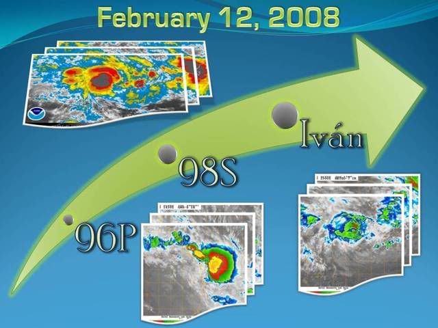
Synoptic situation: At 10am the monsoon trough lay across northern Queensland
with a 999 hPa low located around 50km west of St Lawrence. The low is moving
southeast and is expected to be located on the Sunshine Coast late tonight.

The low is expected to remain an intense system as it moves rapidly towards the
southeast. Very heavy rainfall is likely, both along the coast east of the low
and extending inland to its south. The heaviest falls of rain have cleared the
Central Coast area and will generally be confined to the south of St Lawrence
today.

Locally damaging wind gusts up to 90 km/h are also expected east of the low
reaching 110 km/h in coastal areas exposed to the north including Hervey Bay.
Southeasterly wind gusts to 90 km/h are expected to develop over the Southeast
Coast district tonight.


The northerly winds will bring large waves into Hervey Bay and other areas of
the coastline exposed to the north. Tides will be higher than normal.

Winds will gradually ease from the north in the Central Coast and Whitsundays
district during the day.

The State Emergency Service advises that people in the affected area should:

- seek shelter, indoors where possible, and never under trees.
- secure outdoor items.
- beware of fallen trees and powerlines.
- avoid driving, walking or riding through flood waters.
- if near the coastline, stay well away from the water's edge.


The next warning is due to be issued by 5 pm EST Tuesday.

This warning is also available through TV and Radio broadcasts; the Bureau's
website at http://www.bom.gov.au or call 1300 659 219. The Bureau and State Emergency
Service would appreciate this warning being broadcast regularly
0 likes   

User avatar
Crostorm
Category 5
Category 5
Posts: 2060
Age: 49
Joined: Mon Dec 25, 2006 3:51 pm
Location: Croatia-Europe
Contact:

Re: Gulf of Carpentaria: Invest 96P <=> JTWC: Fair

#43 Postby Crostorm » Mon Feb 11, 2008 8:07 pm

Queensland

PRIORITY
Coastal Waters Wind Warning
For St Lawrence to Point Danger including Hervey Bay and Moreton Bay.
Issued at 10:05 am EST on Tuesday 12 February 2008

Synoptic Situation
Monsoon lows near St Lawrence and Double Island Point expected to merge and move SE off the Sunshine coast this evening. Low then forecast to move rapidly SE.

Storm Force Wind Warning
Sandy Cape to Point Danger
Expect SE winds 40/50 knots on the southern and western side of the low forecast to form off the Sunshine coast this evening. These storm force winds to ease to gales as the low moves offshore early Wednesday morning. Seas rising 3 to 4 metres.

Gale Warning
St Lawrence to Point Danger including Hervey and Moreton Bay
N/NW winds 30/40 knots, tend NE/SE south of Double Island Point. Seas rising to 3.5 metres.


CANCELLED Cardwell to St Lawrence

The next warning will be issued by 5pm EST Tuesday.
0 likes   

Coredesat

#44 Postby Coredesat » Mon Feb 11, 2008 9:57 pm

Appears to be over water now.

Image
0 likes   

Coredesat

#45 Postby Coredesat » Tue Feb 12, 2008 2:05 am

(1) THE AREA OF CONVECTION PREVIOUSLY LOCATED NEAR 19.8S
143.6E, APPROXIMATELY 210 NM SOUTHWEST OF CAIRNS, AUSTRALIA, IS
EXPECTED TO BECOME FULLY EMBEDDED IN AN APPROACHING MID-LATITUDE
TROUGH OVER THE NEXT 24 HOURS AND DEVELOP AS AN EXTRATROPICAL
LOW PRESSURE AREA AS IT MOVES SOUTHEASTWARD. THEREFORE, THIS
AREA IS NO LONGER CONSIDERED SUSPECT FOR THE DEVELOPMENT OF A
SIGNIFICANT TROPICAL CYCLONE OVER THE NEXT 24 HOURS.
0 likes   

User avatar
Chacor
Category 5
Category 5
Posts: 10229
Joined: Mon Oct 02, 2006 10:43 pm
Location: Singapore

#46 Postby Chacor » Tue Feb 12, 2008 9:26 am

WOAU01 ABRF 121248
IDQ20008
SECURITE
1 UPDATED
HIGH SEAS WEATHER WARNING FOR METAREA 10 ISSUED BY THE AUSTRALIAN BUREAU OF
METEOROLOGY, BRISBANE 1248 UTC 12 February 2008

GALE WARNING FOR NORTH EASTERN AREA

SITUATION
At 121200 UTC a monsoon low located near 25S 153E moving SE. Centre is expected
near 28S 157E at 130000 UTC and 31S166E at 131200 UTC.

AREA AFFECTED
Within 150 NM of the low in the eastern semi-circle at first but extending
around the low after 121800UTC.

FORECAST
Within 150 NM of low centre: NW to NE winds 30/40 knots in the eastern
semi-circle at first. Clockwise winds 34/45 knots extending completely around
the low centre after 121800UTC. Seas rising very rough.
REMARKS

Next warning will be issued by 121900UTC.

TPPS10 PGTW 121240

A. TROPICAL DISTURBANCE 96P (E OF AUSTRALIA)

B. 12/1130Z

C. 24.9S

D. 153.2E

E. FIVE/MTSAT

F. T2.0/2.0/STT: D0.5/06HRS (12/1130Z)


G. IR/EIR

38A/PBO SBC/ANMTN. CNVCTN WRAPS .40 ON LOG10 SPIRAL
YIELDING A DT OF 2.5. PT YIELDS A 2.0. DBO PT.

Incidentally, this is no longer in the GoC, so the topic needs updating.
0 likes   

User avatar
HURAKAN
Professional-Met
Professional-Met
Posts: 46086
Age: 37
Joined: Thu May 20, 2004 4:34 pm
Location: Key West, FL
Contact:

#47 Postby HURAKAN » Tue Feb 12, 2008 9:39 am

Image

Strong convection.
0 likes   

User avatar
HURAKAN
Professional-Met
Professional-Met
Posts: 46086
Age: 37
Joined: Thu May 20, 2004 4:34 pm
Location: Key West, FL
Contact:

#48 Postby HURAKAN » Tue Feb 12, 2008 11:00 am

Image
0 likes   

User avatar
Chacor
Category 5
Category 5
Posts: 10229
Joined: Mon Oct 02, 2006 10:43 pm
Location: Singapore

#49 Postby Chacor » Tue Feb 12, 2008 9:35 pm

There's no accent mark on Ivan in this basin.
0 likes   


Return to “2008”

Who is online

Users browsing this forum: No registered users and 43 guests