NW Australia: Tropical Cyclone Ophelia

Moderator: S2k Moderators

Message
Author
User avatar
HURAKAN
Professional-Met
Professional-Met
Posts: 46086
Age: 37
Joined: Thu May 20, 2004 4:34 pm
Location: Key West, FL
Contact:

NW Australia: Tropical Cyclone Ophelia

#1 Postby HURAKAN » Mon Feb 25, 2008 5:16 am

TROPICAL CYCLONE OUTLOOK
FOR THE AREA BETWEEN LONGITUDES 125 EAST - 142 EAST
Issued by the BUREAU OF METEOROLOGY, DARWIN
at 2:15 pm CST Monday 25 February 2008

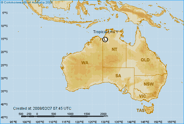
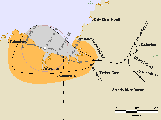
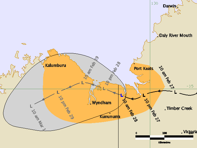
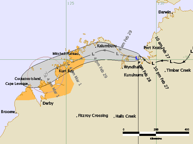
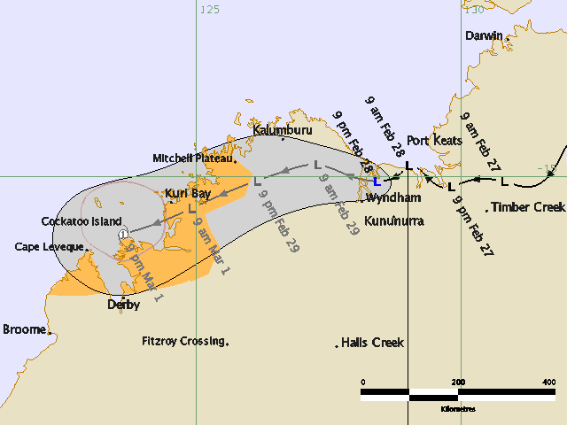
A TROPICAL LOW [1002 hPa] is located southwest of Katherine near the base of the
Top End. At 12.30pm it was near 14.5S 132E, moving slowly west. The LOW is
expected to drift west-northwest over the next few days and could move over the
Joseph Bonaparte Gulf by mid-week where it may deepen further.

The potential for development into a Tropical Cyclone over the next
few days is estimated to be:
Tuesday: low,
Wednesday: low,
Thursday: moderate.

A second, weak TROPICAL LOW [1005 hPa] is located near Mornington Island in the
southern Gulf of Carpentaria. It is expected that this low will move southward
and be over land before any significant intensification occurs.

NOTE: Development Potential is an estimate of the probability of tropical
cyclone development for each day... Low = 10% or less, Moderate = 20% - 40%,
High = 50% or more.

DARWIN Regional Forecasting Centre.

Image

Nothing imminent.
0 likes   

G.B.
Tropical Storm
Tropical Storm
Posts: 177
Joined: Mon Feb 04, 2008 4:38 am
Location: Sydney, Australia

Re: Northern Territory: Invest 94S

#2 Postby G.B. » Wed Feb 27, 2008 2:54 am

IDDP0002
Australian Government Bureau of Meteorology
Northern Territory
Darwin Regional Forecasting Centre

PRIORITY

MEDIA: The Standard Emergency Warning Signal should NOT be used with this
warning.

TROPICAL CYCLONE WATCH

TROPICAL CYCLONE ADVICE NUMBER 1
Issued by the BUREAU OF METEOROLOGY, DARWIN
at 5:01 pm CST [4:31 pm WDT] Wednesday 27 February 2008

A CYCLONE WATCH has been declared for a developing tropical low for coastal
areas from Kalumburu [WA] to Port Keats [NT].

At 3:30 pm CST [3:00 pm WDT] a TROPICAL LOW was estimated to be 75 kilometres
north northwest of Timber Creek and 165 kilometres east northeast of Kununurra
and moving west at 13 kilometres per hour.

There is the possibility of a TROPICAL CYCLONE developing in the southern Joseph
Bonaparte Gulf on Friday. GALES are not expected in coastal areas within the
next 24 hours, however gales could develop later.

Details of TROPICAL LOW at 3:30 pm CST [3:00 pm WDT]:
. Centre located near...... 15.1 degrees South 130.1 degrees East
. Location accuracy........ within 28 kilometres
. Recent movement.......... towards the west at 13 kilometres per hour
. Wind gusts near centre... 85 kilometres per hour
. Severity category........ below cyclone intensity
. Central pressure......... 1001 hectoPascals

The next advice will be issued by 11:00 pm CST [10:30 pm WDT] Wednesday 27
February.


This advice is available on telephone NT-1300 659 211 and WA-1300 659 210

DARWIN Tropical Cyclone Warning Centre

Image

Image

Image

Obviously not expected to be severe
0 likes   

User avatar
Craiga74
Tropical Low
Tropical Low
Posts: 42
Age: 49
Joined: Thu Feb 21, 2008 8:59 am
Location: Port Hedland, Australia
Contact:

#3 Postby Craiga74 » Wed Feb 27, 2008 5:35 am

"Obviously not expected to be severe"

G.B - Once this one reaches the Indian Ocean as it is expected to do, I think you'll see it ramp up a bit then, it has good convection for a system still over land. Be good if it heads my way to provide some much needed rain
0 likes   

G.B.
Tropical Storm
Tropical Storm
Posts: 177
Joined: Mon Feb 04, 2008 4:38 am
Location: Sydney, Australia

Re: Northern Territory: Invest 94S

#4 Postby G.B. » Wed Feb 27, 2008 6:04 am

:uarrow: Well let's hope you are right. Would gladly give you some of our rain.
0 likes   

User avatar
Chacor
Category 5
Category 5
Posts: 10229
Joined: Mon Oct 02, 2006 10:43 pm
Location: Singapore

#5 Postby Chacor » Wed Feb 27, 2008 6:13 am

Impressive for it being over land.
0 likes   

User avatar
Craiga74
Tropical Low
Tropical Low
Posts: 42
Age: 49
Joined: Thu Feb 21, 2008 8:59 am
Location: Port Hedland, Australia
Contact:

#6 Postby Craiga74 » Wed Feb 27, 2008 10:33 am

IDDP0002
Australian Government Bureau of Meteorology
Northern Territory
Darwin Regional Forecasting Centre

PRIORITY

Media: The Standard Emergency Warning Signal should NOT be used with this
warning.

TROPICAL CYCLONE WATCH

TROPICAL CYCLONE ADVICE NUMBER 2
Issued by the BUREAU OF METEOROLOGY, DARWIN
at 11:00 pm CST [10:30 pm WDT] Wednesday 27 February 2008

A Cyclone WATCH is current for coastal and island communities from Kalumburu
[WA] to Port Keats [NT].

At 9:30 pm CST [9:00 pm WDT] a developing Tropical Low was estimated to be 105
kilometres northeast of Kununurra and 110 kilometres south of Port Keats and
moving west at 11 kilometres per hour.

There is the possibility of a TROPICAL CYCLONE developing in the southern Joseph
Bonaparte Gulf on Friday. GALES are not expected in coastal areas within the
next 24 hours, however gales could develop later.

Details of Tropical Low at 9:30 pm CST [9:00 pm WDT]:
.Centre located near...... 15.2 degrees South 129.5 degrees East
.Location accuracy........ within 46 kilometres
.Recent movement.......... towards the west at 11 kilometres per hour
.Wind gusts near centre... 85 kilometres per hour
.Severity category........ below cyclone intensity
.Central pressure......... 1003 hectoPascals

The next advice will be issued by 5 am CST [4:30 am WDT] Thursday 28 February
0 likes   

User avatar
HURAKAN
Professional-Met
Professional-Met
Posts: 46086
Age: 37
Joined: Thu May 20, 2004 4:34 pm
Location: Key West, FL
Contact:

#7 Postby HURAKAN » Wed Feb 27, 2008 2:18 pm

Image

Australian Government Bureau of Meteorology
Northern Territory
Darwin Regional Forecasting Centre

PRIORITY

Media: The Standard Emergency Warning Signal should NOT be used with this
warning.

TROPICAL CYCLONE WATCH

TROPICAL CYCLONE ADVICE NUMBER 3
Issued by the BUREAU OF METEOROLOGY, DARWIN
at 4:28 am CST [3:58 am WDT] Thursday 28 February 2008

A Cyclone WATCH is current for coastal and island communities from Kalumburu
[WA] to Port Keats [NT].

At 3:30 am CST [3:00 am WDT] a developing Tropical Low was estimated to be 75
kilometres northeast of Kununurra and 125 kilometres south southwest of Port
Keats and moving west southwest at 6 kilometres per hour.

There is the possibility of a TROPICAL CYCLONE developing in the southern Joseph
Bonaparte Gulf on Friday. GALES are not expected in coastal areas within the
next 24 hours, however gales could develop later.

Details of Tropical Low at 3:30 am CST [3:00 am WDT]:
.Centre located near...... 15.3 degrees South 129.2 degrees East
.Location accuracy........ within 46 kilometres
.Recent movement.......... towards the west southwest at 6 kilometres per hour
.Wind gusts near centre... 85 kilometres per hour
.Severity category........ below cyclone intensity
.Central pressure......... 1002 hectoPascals

The next advice will be issued by 11 am CST [10:30 am WDT] Thursday 28 February.

This advice is available on telephone NT-1300 659 211 and WA-1300 659 210

DARWIN Tropical Cyclone Warning Centre

Image
0 likes   

G.B.
Tropical Storm
Tropical Storm
Posts: 177
Joined: Mon Feb 04, 2008 4:38 am
Location: Sydney, Australia

Re: Northern Territory: Invest 94S

#8 Postby G.B. » Wed Feb 27, 2008 8:44 pm

Image

IDDP0002
Australian Government Bureau of Meteorology
Northern Territory
Darwin Regional Forecasting Centre

PRIORITY

Media: The Standard Emergency Warning Signal should NOT be used with this
warning.

TROPICAL CYCLONE WATCH

TROPICAL CYCLONE ADVICE NUMBER 4
Issued by the BUREAU OF METEOROLOGY, DARWIN
at 10:53 am CST [10:23 am WDT] Thursday 28 February 2008

A Cyclone WATCH is current for coastal and island communities from Kalumburu
[WA] to Port Keats [NT].

At 9:30 am CST [9:00 am WDT] a developing Tropical Low was estimated to be 75
kilometres north northeast of Kununurra and 120 kilometres south southwest of
Port Keats and moving west northwest at 9 kilometres per hour.

The tropical low is expected to remain over land close to the coast, but may
move into the Joseph Bonaparte Gulf overnight or on Friday. There is the
possibility of a TROPICAL CYCLONE developing on Friday. GALES are not expected
in coastal areas within the next 24 hours, however gales could develop later.

Details of Tropical Low at 9:30 am CST [9:00 am WDT]:
.Centre located near...... 15.2 degrees South 129.1 degrees East
.Location accuracy........ within 46 kilometres
.Recent movement.......... towards the west northwest at 9 kilometres per hour
.Wind gusts near centre... 85 kilometres per hour
.Severity category........ below cyclone intensity
.Central pressure......... 1003 hectoPascals

The next advice will be issued by 5 pm CST [4:30 pm WDT] Thursday 28 February.

This advice is available on telephone NT-1300 659 211 and WA-1300 659 210

DARWIN Tropical Cyclone Warning Centre
0 likes   

G.B.
Tropical Storm
Tropical Storm
Posts: 177
Joined: Mon Feb 04, 2008 4:38 am
Location: Sydney, Australia

Re: Northern Territory: Invest 94S

#9 Postby G.B. » Wed Feb 27, 2008 8:57 pm

787
abio10 pgtw 271800
msgid/genadmin/navpacmetoccen Pearl Harbor hi/jtwc//
subj/significant tropical weather advisory for the Indian
/Ocean/271800z-281800zfeb2008//
rmks/
1. North Indian Ocean area (Malay Peninsula west to coast of Africa):
a. Tropical cyclone summary: none.
B. Tropical disturbance summary: none.
2. South Indian Ocean area (135e west to coast of Africa):
a. Tropical cyclone summary: none.
B. Tropical disturbance summary:
(1) the area of convection previously located near 15.3s
130.1e, is now located near 15.2s 129.4e, approximately 180 nm
south-southwest of Darwin, Australia. Animated infrared satellite
imagery and wyndham radar imagery depict a well-defined low-level
circulation center (LLCC) with convective banding mainly confined to
the southern semi-Circle. The LLCC remains over land and is tracking
west-northwestward at 05 knots near the coastline of the Joseph
Bonaparte Gulf. Upper-level analysis indicates a marginal
environment with diffluent easterlies aloft and moderate vertical
wind shear. Vertical wind shear is forecast to decrease over the
next 24 hours and the potential exists for the disturbance to track
out over water where intensification is possible. Maximum sustained
surface winds are estimated at 23 to 28 knots. Minimum sea level
pressure is estimated to be near 1001 mb. Based on the improved
consolidation and proximity to the coast, the potential for the
development of a significant tropical cyclone within the next 24
hours is upgraded to fair.
(2) no other suspect areas.
Forecast team: Bravo//
0 likes   

G.B.
Tropical Storm
Tropical Storm
Posts: 177
Joined: Mon Feb 04, 2008 4:38 am
Location: Sydney, Australia

Re: Northern Territory: Invest 94S

#10 Postby G.B. » Thu Feb 28, 2008 12:51 am

IDW10800
Australian Government Bureau of Meteorology
Western Australia

TROPICAL CYCLONE OUTLOOK FOR NORTHWESTERN AUSTRALIA
Issued at 2:09pm WDT on Thursday the 28th of February 2008
For the area south of LATITUDE 10 SOUTH between LONGITUDES 110 - 125 EAST

There are no significant tropical lows currently in the region. However, a
tropical low [1003 hPa] was located 130km northeast of Wyndham, near 14.6S
128.9E at midday WDT. A Tropical Cyclone Advice is current for this system,
please refer to the latest advice for details. This low is expected to move west
into the region on Saturday or Sunday and may intensify off the west Kimberley
coast. The likelihood of a tropical cyclone occurring in the next three days is:
Friday : Low
Saturday : Moderate
Sunday : High

** NOTE: Development potential is an estimate of the probability of **
** tropical cyclone development within a 24 hour period. **
** LOW = 10% or less MODERATE = 20-40% HIGH = 50% or more **
0 likes   

User avatar
Craiga74
Tropical Low
Tropical Low
Posts: 42
Age: 49
Joined: Thu Feb 21, 2008 8:59 am
Location: Port Hedland, Australia
Contact:

#11 Postby Craiga74 » Thu Feb 28, 2008 2:35 am

IDDP0002
Australian Government Bureau of Meteorology
Northern Territory
Darwin Regional Forecasting Centre

PRIORITY

Media: The Standard Emergency Warning Signal should NOT be used with this
warning.

TROPICAL CYCLONE WATCH

TROPICAL CYCLONE ADVICE NUMBER 5
Issued by the BUREAU OF METEOROLOGY, DARWIN
at 4:46 pm CST [4:16 pm WDT] Thursday 28 February 2008

A Cyclone WATCH has been declared for coastal and island communities from Cape
Leveque to Kalumburu in Western Australia.
The Cyclone WATCH from Port Keats in the Northern territory to Kalumburu in
Western Australia has been cancelled.

At 3:30 pm CST [3:00 pm WDT] a developing Tropical Low was estimated to be 100
kilometres north of Kununurra and 100 kilometres southwest of Port Keats and
moving west at 6 kilometres per hour.

The tropical low is expected to continue moving west near the southern coast of
the Joseph Bonaparte Gulf tonight, then over the north Kimberley region on
Friday. The low is not expected to develop into a TROPICAL CYCLONE in the Joseph
Bonaparte Gulf, but may develop once it moves off the west Kimberley coast on
Saturday. GALES are not expected in coastal areas within the next 24 hours,
however gales could develop later.

Details of Tropical Low at 3:30 pm CST [3:00 pm WDT]:
.Centre located near...... 14.9 degrees South 128.9 degrees East
.Location accuracy........ within 55 kilometres
.Recent movement.......... towards the west at 6 kilometres per hour
.Wind gusts near centre... 85 kilometres per hour
.Severity category........ below cyclone intensity
.Central pressure......... 1000 hectoPascals

The next advice will be issued by 11 pm CST [10:30 pm WDT] Thursday 28 February.

This advice is available on telephone NT-1300 659 211 and WA-1300 659 210
0 likes   

User avatar
Craiga74
Tropical Low
Tropical Low
Posts: 42
Age: 49
Joined: Thu Feb 21, 2008 8:59 am
Location: Port Hedland, Australia
Contact:

Re: Northern Territory: Invest 94S

#12 Postby Craiga74 » Thu Feb 28, 2008 2:36 am

My trip I have planned to Broome over the weekend could get interesting with this one :D
0 likes   

G.B.
Tropical Storm
Tropical Storm
Posts: 177
Joined: Mon Feb 04, 2008 4:38 am
Location: Sydney, Australia

Re: Northern Territory: Invest 94S

#13 Postby G.B. » Thu Feb 28, 2008 2:58 am

:uarrow: Looks like it could

Image
0 likes   

User avatar
HURAKAN
Professional-Met
Professional-Met
Posts: 46086
Age: 37
Joined: Thu May 20, 2004 4:34 pm
Location: Key West, FL
Contact:

#14 Postby HURAKAN » Thu Feb 28, 2008 6:57 am

Image
0 likes   

G.B.
Tropical Storm
Tropical Storm
Posts: 177
Joined: Mon Feb 04, 2008 4:38 am
Location: Sydney, Australia

Re: Northern Territory: Invest 94S

#15 Postby G.B. » Thu Feb 28, 2008 8:19 am

IDDP0002
Australian Government Bureau of Meteorology
Northern Territory
Darwin Regional Forecasting Centre

PRIORITY

Media: The Standard Emergency Warning Signal should NOT be used with this
warning.

TROPICAL CYCLONE WATCH

TROPICAL CYCLONE ADVICE NUMBER 6
Issued by the BUREAU OF METEOROLOGY, DARWIN
at 11:00 pm CST [10:30 pm WDT] Thursday 28 February 2008

A Cyclone WATCH is current for coastal and island communities from Cape Leveque
to Mitchell Plateau.

At 9:30 pm CST [9:00 pm WDT] a Tropical Low was estimated to be 85 kilometres
north northwest of Kununurra and 210 kilometres east southeast of Kalumburu and
moving west southwest at 6 kilometres per hour.

The tropical low is expected to continue moving west near the southern coast of
the Joseph Bonaparte Gulf tonight, then over the north Kimberley region on
Friday. The low is not expected to develop into a TROPICAL CYCLONE in the Joseph
Bonaparte Gulf, but may develop once it moves off the west Kimberley coast on
Saturday. GALES are not expected in coastal areas within the next 24 hours,
however gales could develop later.

Details of Tropical Low at 9:30 pm CST [9:00 pm WDT]:
.Centre located near...... 15.1 degrees South 128.4 degrees East
.Location accuracy........ within 28 kilometres
.Recent movement.......... towards the west southwest at 6 kilometres per hour
.Wind gusts near centre... 85 kilometres per hour
.Severity category........ below cyclone intensity
.Central pressure......... 1002 hectoPascals

The next advice will be issued by 5 am CST [4:30 am WDT] Friday 29 February.

This advice is available on telephone NT-1300 659 211 and WA-1300 659 210

DARWIN Tropical Cyclone Warning Centre
0 likes   

User avatar
Craiga74
Tropical Low
Tropical Low
Posts: 42
Age: 49
Joined: Thu Feb 21, 2008 8:59 am
Location: Port Hedland, Australia
Contact:

#16 Postby Craiga74 » Thu Feb 28, 2008 8:20 am

You beat me to it GB :cheesy:
0 likes   

G.B.
Tropical Storm
Tropical Storm
Posts: 177
Joined: Mon Feb 04, 2008 4:38 am
Location: Sydney, Australia

Re: Northern Territory: Invest 94S

#17 Postby G.B. » Thu Feb 28, 2008 8:27 am

Sorry Craiga74

Image
0 likes   

User avatar
Chacor
Category 5
Category 5
Posts: 10229
Joined: Mon Oct 02, 2006 10:43 pm
Location: Singapore

#18 Postby Chacor » Thu Feb 28, 2008 10:01 am

XAU01 ADRM 281305
IDD20020
TROPICAL CYCLONE TECHNICAL BULLETIN: AUSTRALIA - NORTHERN REGION
ISSUED BY DARWIN TROPICAL CYCLONE WARNING CENTRE
AT: 1304 UTC 28/02/2008
NAME: TROPICAL LOW
DATA AT: 1200 UTC
LATITUDE: 15.1S
LONGITUDE: 128.4E
LOCATION ACCURACY: WITHIN 15 NM [28 KM]
MOVEMENT TOWARDS: WEST SOUTHWEST [243 DEG]
SPEED OF MOVEMENT: 3 KNOTS [6 KM/H]
MAXIMUM 10-MINUTE WIND: 25 KNOTS [45 KM/H]
MAXIMUM 3-SECOND WIND GUST: 45 KNOTS [85 KM/H]
CENTRAL PRESSURE: 1002 HPA
RADIUS OF 34-KNOT WINDS NE QUADRANT:
RADIUS OF 34-KNOT WINDS SE QUADRANT:
RADIUS OF 34-KNOT WINDS SW QUADRANT:
RADIUS OF 34-KNOT WINDS NW QUADRANT:
RADIUS OF 48-KNOT WINDS NE QUADRANT:
RADIUS OF 48-KNOT WINDS SE QUADRANT:
RADIUS OF 48-KNOT WINDS SW QUADRANT:
RADIUS OF 48-KNOT WINDS NW QUADRANT:
RADIUS OF 64-KNOT WINDS:

FORECAST DATA
DATE/TIME : LOCATION : LOC. ACCURACY: MAX WIND : CENTRAL PRESSURE
[UTC] : DEGREES : NM [KM]: KNOTS[KM/H]: HPA
+12: 29/0000: 14.8S 127.3E: 035 [065]: 025 [045]: 1000
+24: 29/1200: 15.1S 126.1E: 050 [095]: 025 [045]: 998
+36: 01/0000: 15.6S 124.9E: 055 [100]: 025 [045]: 994
+48: 01/1200: 16.1S 123.6E: 065 [120]: 035 [065]: 988
+60: 02/0000: 16.5S 122.1E: 075 [140]: 040 [075]: 986
+72: 02/1200: 16.6S 120.3E: 080 [150]: 050 [095]: 978
REMARKS:
DEEP CONVECTION DISPLACED 1 DEG SW OF LLCC, SHEAR PATTERN ANALYSIS YIELDS
DT=1.5. FT=1.5 BASED ON MET AND DT. VERTICAL WIND SHEAR REMAINS STRONG WITH
20-30KT EASTERLY WINDS AT 200HPA OVER SYSTEM. MODELS HAVE BECOME CONSISTENT
[EXCLUDING TXLAPS] WITH WNW THEN WSW MOVEMENT ACROSS KIMBERLEY REGION. TC
DEVELOPMENT POSSIBLE LATER ON SATURDAY WEST OF KIMBERLEY COAST, BUT DEVELOPMENT
RATE LIKELY TO BE SLOW DUE TO VERTICAL WIND SHEAR.
==
THE NEXT BULLETIN FOR THIS SYSTEM WILL BE ISSUED BY: 28/1930 UTC BY DARWIN TCWC.
0 likes   

User avatar
HURAKAN
Professional-Met
Professional-Met
Posts: 46086
Age: 37
Joined: Thu May 20, 2004 4:34 pm
Location: Key West, FL
Contact:

#19 Postby HURAKAN » Thu Feb 28, 2008 4:14 pm

Australian Government Bureau of Meteorology
Western Australia

TROPICAL CYCLONE OUTLOOK FOR NORTHWESTERN AUSTRALIA
Issued at 2:09pm WDT on Thursday the 28th of February 2008
For the area south of LATITUDE 10 SOUTH between LONGITUDES 110 - 125 EAST

There are no significant tropical lows currently in the region. However, a
tropical low [1003 hPa] was located 130km northeast of Wyndham, near 14.6S
128.9E at midday WDT. A Tropical Cyclone Advice is current for this system,
please refer to the latest advice for details. This low is expected to move west
into the region on Saturday or Sunday and may intensify off the west Kimberley
coast. The likelihood of a tropical cyclone occurring in the next three days is:
Friday : Low
Saturday : Moderate
Sunday : High

** NOTE: Development potential is an estimate of the probability of **
** tropical cyclone development within a 24 hour period. **
** LOW = 10% or less MODERATE = 20-40% HIGH = 50% or more **
0 likes   

User avatar
HURAKAN
Professional-Met
Professional-Met
Posts: 46086
Age: 37
Joined: Thu May 20, 2004 4:34 pm
Location: Key West, FL
Contact:

Re: Northern Territory: Invest 94S

#20 Postby HURAKAN » Thu Feb 28, 2008 4:18 pm

Image

Australian Government Bureau of Meteorology
Northern Territory
Darwin Regional Forecasting Centre

PRIORITY

Media: The Standard Emergency Warning Signal should NOT be used with this
warning.

TROPICAL CYCLONE WATCH

TROPICAL CYCLONE ADVICE NUMBER 7
Issued by the BUREAU OF METEOROLOGY, DARWIN
at 5:00 am CST [4:30 am WDT] Friday 29 February 2008

A Cyclone WATCH is current for coastal and island communities from Cape Leveque
to Mitchell Plateau.

At 3:30 am CST [3:00 am WDT] a Tropical Low was estimated to be 125 kilometres
northwest of Kununurra and 155 kilometres southeast of Kalumburu and moving west
at 10 kilometres per hour.

The tropical low is expected to move to the west northwest over the north
Kimberley region today. The low is not expected to develop into a TROPICAL
CYCLONE in the Joseph Bonaparte Gulf, but may develop once it moves off the west
Kimberley coast on Saturday. GALES are not expected in coastal areas within the
next 24 hours, however gales could develop later.

Details of Tropical Low at 3:30 am CST [3:00 am WDT]:
.Centre located near...... 15.1 degrees South 127.8 degrees East
.Location accuracy........ within 28 kilometres
.Recent movement.......... towards the west at 10 kilometres per hour
.Wind gusts near centre... 85 kilometres per hour
.Severity category........ below cyclone intensity
.Central pressure......... 1001 hectoPascals

The next advice will be issued by 11 am CST [10:30 am WDT] Friday 29 February.

This advice is available on telephone NT-1300 659 211 and WA-1300 659 210

DARWIN Tropical Cyclone Warning Centre
0 likes   


Return to “2008”

Who is online

Users browsing this forum: No registered users and 19 guests