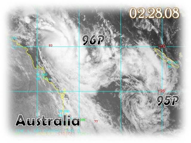
Near Eastern Australia: Tropical Cyclone 20P

Moderator: S2k Moderators

Message
Author
G.B.
Tropical Storm
Tropical Storm
Posts: 177
Joined: Mon Feb 04, 2008 4:38 am
Location: Sydney, Australia

Near Eastern Australia: Tropical Cyclone 20P

#1 Postby G.B. » Wed Feb 27, 2008 3:09 am

IDQ10810
Australian Government Bureau of Meteorology
Queensland
Tropical Cyclone Warning Centre

Media: This message is issued daily for the information of interested parties.
Media are NOT required to broadcast this message.

TROPICAL CYCLONE OUTLOOK
for the Coral Sea West of Longitude 160 East
Issued at 2:30pm on Wednesday the 27th of February 2008

A small low is situated off the North Tropical Coast about 210 km east of
Innisfail. This low will remain near stationary until Thursday morning, when it
should adopt a southeasterly track, parallel to the coast to be about 200 to 300
km off the Central Coast on Friday. Interaction with an approaching upper level
trough may lead to a strengthening of the low as it begins to move to the
southeast, however the system has a low probability of developing into a
tropical cyclone.


A second tropical low situated on the monsoon trough near 17S 160E. This low is
expected to move in a southerly direction to be roughly near 25S 160E by Friday.
This system will gradually intensify as it moves south but is not expected to
develop into a tropical cyclone within the next three days.

Tropical Cyclone outlooks issued by Brisbane can be accessed through the
Bureau's Home Page http://www.bom.gov.au.

Please note that the Darwin Regional Forecasting Centre issues Tropical
Cyclone Outlooks that cover the Gulf of Carpentaria. See
http:/www.bom.gov.au/weather/nt/cyclone/ or to subscribe to this service
call Darwin 08 8920 3820.

Image
0 likes   

G.B.
Tropical Storm
Tropical Storm
Posts: 177
Joined: Mon Feb 04, 2008 4:38 am
Location: Sydney, Australia

Re: Tropical Disturbance (96P)

#2 Postby G.B. » Thu Feb 28, 2008 7:13 am

IDQ10810

UPDATED
Australian Government Bureau of Meteorology
Queensland
Tropical Cyclone Warning Centre

Media: This message is issued daily for the information of interested parties.
Media are NOT required to broadcast this message.

TROPICAL CYCLONE OUTLOOK
for the Coral Sea West of Longitude 160 East
Issued at 5:26pm on Thursday the 28th of February 2008

A tropical low is situated off the North Tropical Coast about 160 km east of
Innisfail. The low has shown signs of development over the past few hours, with
overall organisation improving. Interaction with an approaching upper level
trough may lead to further strengthening in the next 24 hours. The probability
of the low developing into a tropical cyclone in the next 24 hours is upgraded
to MODERATE. The low should begin to track towards the southeast late today, and
be located about 450 km east of Mackay on Friday evening
.

A second tropical low situated on the monsoon trough near 21S 160E. This low is
expected to move in a southerly direction to be roughly near 25S 160E by Friday.
This system also has a low probability of developing into a tropical cyclone
within the next three days.

Tropical Cyclone outlooks issued by Brisbane can be accessed through the
Bureau's Home Page http://www.bom.gov.au.

Image

Please note that the Darwin Regional Forecasting Centre issues Tropical
Cyclone Outlooks that cover the Gulf of Carpentaria. See
http:/www.bom.gov.au/weather/nt/cyclone/ or to subscribe to this service
call Darwin 08 8920 3820.
0 likes   

User avatar
HURAKAN
Professional-Met
Professional-Met
Posts: 46086
Age: 37
Joined: Thu May 20, 2004 4:34 pm
Location: Key West, FL
Contact:

#3 Postby HURAKAN » Thu Feb 28, 2008 4:12 pm

Image

28/1430 UTC 18.0S 149.1E T2.0/2.0 96P -- South Pacific Ocean
0 likes   

User avatar
HURAKAN
Professional-Met
Professional-Met
Posts: 46086
Age: 37
Joined: Thu May 20, 2004 4:34 pm
Location: Key West, FL
Contact:

#4 Postby HURAKAN » Thu Feb 28, 2008 9:44 pm

Image

Image

WTPS21 PGTW 290200
MSGID/GENADMIN/NAVPACMETOCCEN PEARL HARBOR HI//
SUBJ/TROPICAL CYCLONE FORMATION ALERT//
RMKS/
1. FORMATION OF A SIGNIFICANT TROPICAL CYCLONE IS POSSIBLE WITHIN
150 NM EITHER SIDE OF A LINE FROM 18.1S 150.6E TO 23.6S 160.0E
WITHIN THE NEXT 12 TO 24 HOURS. AVAILABLE DATA DOES NOT JUSTIFY
ISSUANCE OF NUMBERED TROPICAL CYCLONE WARNINGS AT THIS TIME.
WINDS IN THE AREA ARE ESTIMATED TO BE 25 TO 30 KNOTS. METSAT IM-
AGERY AT 290000Z INDICATES THAT A CIRCULATION CENTER IS LOCATED
NEAR 18.9S 151.7E. THE SYSTEM IS MOVING EAST-SOUTHEASTWARD AT 18
KNOTS.
2. REMARKS: THE AREA OF CONVECTION PREVIOUSLY LOCATED NEAR 17.6S
147.9E, IS NOW LOCATED NEAR 18.9S 151.7E, APPROXIMATELY 365 NM
EAST-SOUTHEAST OF CAIRNS, AUSTRALIA. RECENT ANIMATED MULTISPECTRAL
IMAGERY SHOWS DEEP CONVECTION HAS DEVELOPED IN THE VICINITY
OF THE LOW LEVEL CIRCULATION CENTER (LLCC). CONVECTIVE BANDING HAS
ALSO DEVELOPED IN THE SOUTHEASTERN QUADRANT, AS SEEN ON A 282153Z
SSMIS MICROWAVE IMAGE. RECENT SURFACE OBSERVATIONS ALSO INDICATE
OVER A 4 MB PRESSURE DROP IN 24 HOURS NEAR THE LLCC. UPPER LEVEL
ANALYSIS REVEALS THE DISTURBANCE IS UNDER A 200 MB ANTICYCLONE,
WHICH IS CREATING FAVORABLE OUTFLOW ALOFT. MAXIMUM SUSTAINED
SURFACE WINDS ARE ESTIMATED AT 25 TO 30 KNOTS. MINIMUM SEA LEVEL
PRESSURE IS ESTIMATED TO BE NEAR 1000 MB. THE POTENTIAL FOR THE
DEVELOPMENT OF A SIGNIFICANT TROPICAL CYCLONE WITHIN THE NEXT
24 HOURS IS UPGRADED TO GOOD.
3. THIS ALERT WILL BE REISSUED, UPGRADED TO WARNING OR CANCELLED
BY 010200Z.//
NNNN

TPPS11 PGTW 290017

A. TROPICAL DISTURBANCE 96P (EAST OF AUSTRAILIA)

B. 28/2330Z

C. 19.2S

D. 151.5E

E. FIVE/MTSAT

F. T2.5/2.5/D1.0/24HRS STT: D1.0/06HRS (28/2330Z)

G. IR/EIR/VIS/MSI

40A/PBO SBC/ANMTN. CONVCTN WRAPS .55 ON LOG10 SPIRAL
YIELDING A DT OF 2.5. MET AND PT AGREE. DBO DT/MET/PT.

GEIS
0 likes   

User avatar
HURAKAN
Professional-Met
Professional-Met
Posts: 46086
Age: 37
Joined: Thu May 20, 2004 4:34 pm
Location: Key West, FL
Contact:

#5 Postby HURAKAN » Thu Feb 28, 2008 10:12 pm

Image
0 likes   

User avatar
Cyclenall
Category 5
Category 5
Posts: 6628
Joined: Thu Jun 08, 2006 10:01 pm
Location: Ontario, Canada

#6 Postby Cyclenall » Thu Feb 28, 2008 10:18 pm

It looks like a 55 knot tropical storm.
0 likes   

G.B.
Tropical Storm
Tropical Storm
Posts: 177
Joined: Mon Feb 04, 2008 4:38 am
Location: Sydney, Australia

Re: Tropical Disturbance (96P): TCFA

#7 Postby G.B. » Thu Feb 28, 2008 11:46 pm

IDQ10810
Australian Government Bureau of Meteorology
Queensland
Tropical Cyclone Warning Centre

Media: This message is issued daily for the information of interested parties.
Media are NOT required to broadcast this message.

TROPICAL CYCLONE OUTLOOK
for the Coral Sea West of Longitude 160 East
Issued at 2:40pm on Friday the 29th of February 2008

A tropical low is situated off the east tropical coast of Qld about 390 km east
north-east of Mackay and moving steadily to the east south-east. The low is
beginning to show signs of weakening. The probability of the low developing into
a tropical cyclone in the next 24 hours is LOW.


Tropical Cyclone outlooks issued by Brisbane can be accessed through the
Bureau's Home Page http://www.bom.gov.au.

Please note that the Darwin Regional Forecasting Centre issues Tropical
Cyclone Outlooks that cover the Gulf of Carpentaria. See
http:/www.bom.gov.au/weather/nt/cyclone/ or to subscribe to this service
call Darwin 08 8920 3820.
0 likes   

User avatar
HURAKAN
Professional-Met
Professional-Met
Posts: 46086
Age: 37
Joined: Thu May 20, 2004 4:34 pm
Location: Key West, FL
Contact:

#8 Postby HURAKAN » Fri Feb 29, 2008 6:08 am

29/0830 UTC 22.1S 154.6E T2.5/2.5 96P -- South Pacific Ocean

Image
0 likes   

User avatar
HURAKAN
Professional-Met
Professional-Met
Posts: 46086
Age: 37
Joined: Thu May 20, 2004 4:34 pm
Location: Key West, FL
Contact:

#9 Postby HURAKAN » Fri Feb 29, 2008 6:16 am

Image

20P is here!
0 likes   

G.B.
Tropical Storm
Tropical Storm
Posts: 177
Joined: Mon Feb 04, 2008 4:38 am
Location: Sydney, Australia

Re: Tropical Disturbance (96P): 20P No Name

#10 Postby G.B. » Fri Feb 29, 2008 6:19 am

Seems BoM may have been wrong. 96P Gone From NRL - is now 20P - No name

Image
0 likes   

User avatar
Crostorm
Category 5
Category 5
Posts: 2060
Age: 49
Joined: Mon Dec 25, 2006 3:51 pm
Location: Croatia-Europe
Contact:

Re: Near Eastern Australia: Tropical Cyclone 20P

#11 Postby Crostorm » Fri Feb 29, 2008 6:40 am

Nice!

Image
0 likes   

User avatar
HURAKAN
Professional-Met
Professional-Met
Posts: 46086
Age: 37
Joined: Thu May 20, 2004 4:34 pm
Location: Key West, FL
Contact:

#12 Postby HURAKAN » Fri Feb 29, 2008 7:27 am

Image

WTPS31 PGTW 290900
MSGID/GENADMIN/NAVPACMETOCCEN PEARL HARBOR HI//
SUBJ/TROPICAL CYCLONE WARNING//
REF/A/MSGID/MSG/NAVPACMETOCCEN PEARL HARBOR HI 290151ZFEB2008//
AMPN/REF A IS A TROPICAL CYCLONE FORMATION ALERT.//
RMKS/
1. TROPICAL CYCLONE 20P WARNING NR 001
01 ACTIVE TROPICAL CYCLONE IN SOUTHPAC
MAX SUSTAINED WINDS BASED ON ONE-MINUTE AVERAGE
---
WARNING POSITION:
290600Z --- NEAR 21.2S 154.3E
MOVEMENT PAST SIX HOURS - 130 DEGREES AT 31 KTS
POSITION ACCURATE TO WITHIN 040 NM
POSITION BASED ON CENTER LOCATED BY SATELLITE
PRESENT WIND DISTRIBUTION:
MAX SUSTAINED WINDS - 030 KT, GUSTS 040 KT
WIND RADII VALID OVER OPEN WATER ONLY
REPEAT POSIT: 21.2S 154.3E
---
FORECASTS:
12 HRS, VALID AT:
291800Z --- 24.1S 158.4E
MAX SUSTAINED WINDS - 035 KT, GUSTS 045 KT
WIND RADII VALID OVER OPEN WATER ONLY
BECOMING EXTRATROPICAL
VECTOR TO 24 HR POSIT: 125 DEG/ 20 KTS
---
24 HRS, VALID AT:
010600Z --- 26.4S 162.0E
MAX SUSTAINED WINDS - 035 KT, GUSTS 045 KT
WIND RADII VALID OVER OPEN WATER ONLY
BECOMING EXTRATROPICAL
VECTOR TO 36 HR POSIT: 120 DEG/ 20 KTS
---
36 HRS, VALID AT:
011800Z --- 28.4S 165.8E
MAX SUSTAINED WINDS - 035 KT, GUSTS 045 KT
WIND RADII VALID OVER OPEN WATER ONLY
EXTRATROPICAL
---
REMARKS:
290900Z POSITION NEAR 21.9S 155.3E.
TROPICAL CYCLONE (TC) 20P (NONAME) LOCATED APPROXIMATELY
385 NM NORTH-NORTHEAST OF BRISBANE, AUSTRALIA, HAS TRACKED
SOUTHEASTWARD AT 31 KNOTS OVER THE PAST 06 HOURS. RECENT
ANIMATED METSAT IMAGERY DEPICTS AN ASYMMETRIC SYSTEM WITH
A WELL-WRAPPED CONVECTIVE BAND ALONG THE SOUTHEASTERN PERI-
PHERY. INITIAL INTENSITY IS BASED ON SATELLITE INTENSITY
ESTIMATES OF 35 KNOTS FROM KNES AND PGTW. THE SYSTEM IS
NOW UNDER THE INFLUENCE OF MODERATE NORTHWESTERLY VERTICAL
WIND SHEAR ASSOCIATED WITH A HIGH AMPLITUDE MID-LATITUDE
TROUGH. THE FAVORABLE DIFFLUENCE ALOFT WILL BE OFFSET BY
THE VERTICAL WIND SHEAR AND KEEP THE SYSTEM AROUND 35 KNOTS
AS IT BEGINS EXTRATROPICAL TRANSITION AT TAU 12. TC 20P
WILL BECOME FULLY EXTRATROPICAL BY TAU 36. THE DYNAMIC AIDS
ARE IN GOOD AGREEMENT WITH THIS FORECAST. THIS WARNING
SUPERSEDES AND CANCELS REF A, NAVPACMETOCCEN 290151ZFEB2008
TROPICAL CYCLONE FORMATION ALERT (WTPS21 PGTW 290200)
MAXIMUM SIGNIFICANT WAVE HEIGHT AT 290600Z IS 13 FEET. NEXT
WARNINGS AT 292100Z AND 010900Z.//
0 likes   

User avatar
P.K.
Professional-Met
Professional-Met
Posts: 5149
Joined: Thu Sep 23, 2004 5:57 pm
Location: Watford, England
Contact:

Re: Near Eastern Australia: Tropical Cyclone 20P

#13 Postby P.K. » Fri Feb 29, 2008 8:19 am

WOAU01 ABRF 291313
IDQ20008
SECURITE

HIGH SEAS WEATHER WARNING FOR METAREA 10 ISSUED BY THE AUSTRALIAN BUREAU OF
METEOROLOGY, BRISBANE 1312 UTC 29 February 2008

GALE WARNING FOR NORTH EASTERN AREA


SITUATION
At 291200UTC a tropical low with central pressure 1000 hPa was centred near
23.0S 155.7E. The low will move to the southeast and be near 24S 159E at
010000UTC and near 25.5S 161E at 011200UTC.
AREA AFFECTED
Within 150 NM of the low in the northeast quadrant and within 100 NM of the
centre in the southwest quadrant.
FORECAST
Clockwise winds 30/40 knots. Seas rough to very rough. Moderate swell.
REMARKS
All ships in the area please send weather reports every three hours. Regular
weather observing ships use normal channels. Other ships please use either
email to marwxqld@bom.gov.au or fax to +61732200221 or satellite to SAC 41
through Land Earth Station Perth 222.

WEATHER BRISBANE
0 likes   

User avatar
HURAKAN
Professional-Met
Professional-Met
Posts: 46086
Age: 37
Joined: Thu May 20, 2004 4:34 pm
Location: Key West, FL
Contact:

#14 Postby HURAKAN » Fri Feb 29, 2008 8:58 am

Image
0 likes   

Squarethecircle
Category 5
Category 5
Posts: 2165
Joined: Fri Oct 19, 2007 4:00 pm
Location: Fairfax, VA

#15 Postby Squarethecircle » Fri Feb 29, 2008 9:45 am

This kind of reminds me of an earlier storm in the same place, although I think this one will probably survive.

Microwave and convective both look positively excellent.
0 likes   

User avatar
wyq614
Category 3
Category 3
Posts: 827
Age: 35
Joined: Sun Dec 02, 2007 12:32 am
Location: Beijing, China (Hometown: Qingdao, China, 36.06N 120.43E)
Contact:

#16 Postby wyq614 » Fri Feb 29, 2008 10:56 am

This may be a system deserted by all the RSMCs. I doubt if it will get a name.
0 likes   

User avatar
Chacor
Category 5
Category 5
Posts: 10229
Joined: Mon Oct 02, 2006 10:43 pm
Location: Singapore

#17 Postby Chacor » Fri Feb 29, 2008 11:02 am

I'll say that Brisbane made the right choice here. Remember that the definition of a TC between BoM and JTWC is different. Especially since the JTWC is projecting extratropicality within 36 hours it's probably past its peak if it were to be named at all.
0 likes   

User avatar
HURAKAN
Professional-Met
Professional-Met
Posts: 46086
Age: 37
Joined: Thu May 20, 2004 4:34 pm
Location: Key West, FL
Contact:

#18 Postby HURAKAN » Fri Feb 29, 2008 1:00 pm

Image

Image

Not looking very good.
0 likes   

User avatar
HURAKAN
Professional-Met
Professional-Met
Posts: 46086
Age: 37
Joined: Thu May 20, 2004 4:34 pm
Location: Key West, FL
Contact:

#19 Postby HURAKAN » Fri Feb 29, 2008 1:06 pm

Image

35kts-996mb
0 likes   

User avatar
HURAKAN
Professional-Met
Professional-Met
Posts: 46086
Age: 37
Joined: Thu May 20, 2004 4:34 pm
Location: Key West, FL
Contact:

#20 Postby HURAKAN » Fri Feb 29, 2008 1:17 pm

TPPS11 PGTW 291806

A. TROPICAL CYCLONE 20P (NO NAME)

B. 29/1730Z

C. 25.1S

D. 159.7E

E. FIVE/MTSAT

F. T2.5/3.0/D1.0/24HRS STT: W0.5/06HRS (29/1730Z)

G. IR/EIR

38A/PBO SBC/ANMTN. CNVCTN WRAP OF .50 ON LOG10 SPIRAL
YIELDS A 2.5 DT. MET AND PT AGREE. DBO DT.

SCANLIN
0 likes   


Return to “2008”

Who is online

Users browsing this forum: No registered users and 22 guests