Northern Territory: Invest 91S

Moderator: S2k Moderators

Message
Author
User avatar
HURAKAN
Professional-Met
Professional-Met
Posts: 46086
Age: 37
Joined: Thu May 20, 2004 4:34 pm
Location: Key West, FL
Contact:

Northern Territory: Invest 91S

#1 Postby HURAKAN » Thu Mar 06, 2008 9:22 pm

Image


TROPICAL CYCLONE OUTLOOK


TROPICAL CYCLONE OUTLOOK
FOR THE AREA BETWEEN LONGITUDES 125 EAST - 142 EAST
Issued by the BUREAU OF METEOROLOGY, DARWIN
at 2:30 pm CST Thursday 6 March 2008

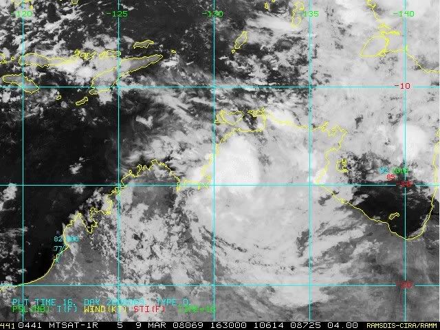
A tropical low, 1007 hPa, is situated near the coast in the northwest Gulf of
Carpentaria. The low is expected to drift slowly west along the north coast
during the next few days.

The potential for development into a Tropical Cyclone over the next few days is
expected to remain LOW.

DARWIN Regional Forecasting Centre.
0 likes   

User avatar
wyq614
Category 3
Category 3
Posts: 827
Age: 35
Joined: Sun Dec 02, 2007 12:32 am
Location: Beijing, China (Hometown: Qingdao, China, 36.06N 120.43E)
Contact:

#2 Postby wyq614 » Thu Mar 06, 2008 9:52 pm

It takes much time for the tropical lows in such area to get well-developed.
0 likes   

G.B.
Tropical Storm
Tropical Storm
Posts: 177
Joined: Mon Feb 04, 2008 4:38 am
Location: Sydney, Australia

Re: Northern Territory: Invest 91S

#3 Postby G.B. » Thu Mar 06, 2008 11:53 pm

TROPICAL CYCLONE OUTLOOK
FOR THE AREA BETWEEN LONGITUDES 125 EAST - 142 EAST
Issued by the BUREAU OF METEOROLOGY, DARWIN
at 2:15 pm CST Friday 7 March 2008

A tropical low, 1007 hPa, over Arnhem Land is expected to drift steadily west
across the northern Top End during the weekend.

The potential for development into a Tropical Cyclone over the next few days is
expected to remain LOW.

NOTE: Development Potential is an estimate of the probability of tropical
cyclone development for each day... Low = 10% or less, Moderate = 20% - 40%,
High = 50% or more.

DARWIN Regional Forecasting Centre.
0 likes   

User avatar
HURAKAN
Professional-Met
Professional-Met
Posts: 46086
Age: 37
Joined: Thu May 20, 2004 4:34 pm
Location: Key West, FL
Contact:

#4 Postby HURAKAN » Sat Mar 08, 2008 1:02 am

Image

Not looking good!
0 likes   

User avatar
HURAKAN
Professional-Met
Professional-Met
Posts: 46086
Age: 37
Joined: Thu May 20, 2004 4:34 pm
Location: Key West, FL
Contact:

#5 Postby HURAKAN » Sun Mar 09, 2008 8:17 am

TROPICAL CYCLONE OUTLOOK


TROPICAL CYCLONE OUTLOOK
FOR THE AREA BETWEEN LONGITUDES 125 EAST - 142 EAST
Issued by the BUREAU OF METEOROLOGY, DARWIN
at 2:15 pm CST Sunday 9 March 2008

A weak tropical low, 1007 hPa, over the west coast of the Top End is steadily
drifting west into the Timor Sea. The low is expected to continue moving west
over the next few days.

The potential for development into a Tropical Cyclone over the next three days
is expected to remain LOW.

NOTE: Development Potential is an estimate of the probability of tropical
cyclone development for each day... Low = 10% or less, Moderate = 20% - 40%,
High = 50% or more.

DARWIN Regional Forecasting Centre.

Image
0 likes   

User avatar
HURAKAN
Professional-Met
Professional-Met
Posts: 46086
Age: 37
Joined: Thu May 20, 2004 4:34 pm
Location: Key West, FL
Contact:

#6 Postby HURAKAN » Sun Mar 09, 2008 1:07 pm

Image

Still here!
0 likes   

G.B.
Tropical Storm
Tropical Storm
Posts: 177
Joined: Mon Feb 04, 2008 4:38 am
Location: Sydney, Australia

Re: Northern Territory: Invest 91S

#7 Postby G.B. » Sun Mar 09, 2008 6:56 pm

This one's looking a little better too :D

Image
0 likes   

User avatar
HURAKAN
Professional-Met
Professional-Met
Posts: 46086
Age: 37
Joined: Thu May 20, 2004 4:34 pm
Location: Key West, FL
Contact:

#8 Postby HURAKAN » Sun Mar 09, 2008 7:07 pm

Closer to the coast, but not much to get excited!!!

Image
0 likes   

G.B.
Tropical Storm
Tropical Storm
Posts: 177
Joined: Mon Feb 04, 2008 4:38 am
Location: Sydney, Australia

Re: Northern Territory: Invest 91S

#9 Postby G.B. » Sun Mar 09, 2008 11:41 pm

Looked better earlier

Image
0 likes   

User avatar
HURAKAN
Professional-Met
Professional-Met
Posts: 46086
Age: 37
Joined: Thu May 20, 2004 4:34 pm
Location: Key West, FL
Contact:

#10 Postby HURAKAN » Mon Mar 10, 2008 4:34 pm

Image

Back to life!!
0 likes   

G.B.
Tropical Storm
Tropical Storm
Posts: 177
Joined: Mon Feb 04, 2008 4:38 am
Location: Sydney, Australia

Re: Northern Territory: Invest 91S

#11 Postby G.B. » Mon Mar 10, 2008 9:34 pm

Gone from NRL
0 likes   


Return to “2008”

Who is online

Users browsing this forum: No registered users and 8 guests