Arabian Sea: Invest 97A

Moderator: S2k Moderators

Message
Author
User avatar
Chacor
Category 5
Category 5
Posts: 10229
Joined: Mon Oct 02, 2006 10:43 pm
Location: Singapore

Arabian Sea: Invest 97A

#1 Postby Chacor » Sat May 24, 2008 9:37 pm

AN AREA OF CONVECTION HAS PERSISTED NEAR 12.9N 64.8E,
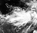
APPROXIMATELY 790 NM EAST OF CAPE GUARDAFUI, SOMALIA. RECENT
ANIMATED INFRARED SATELLITE IMAGERY SHOWS FAIRLY NEW CONVECTION
BUILDING NEAR AN AREA OF INCREASINGLY PRONOUNCED LOW TO MID-LEVEL
CYCLONIC TURNING. THE LOW LEVEL CIRCULATION CENTER (LLCC) IS
PARTIALLY EXPOSED TO THE EAST OF THE CENTRAL CONVECTION DUE TO LOW
TO MODERATE EASTERLY VERTICAL WIND SHEAR. A 242140Z AMSRE MICROWAVE
IMAGE ALSO INDICATES FORMATIVE BANDING BUILDING TO THE SOUTH OF THE
LLCC. THE SYSTEM LIES TO THE SOUTH OF THE SUBTROPICAL RIDGE AXIS
WITH MARGINAL UPPER LEVEL DIFFLUENCE. SEA SURFACE TEMPERATURES AND
OCEAN HEAT CONTENT ARE OPTIMAL. MAXIMUM SUSTAINED SURFACE WINDS ARE
ESTIMATED AT 15 TO 20 KNOTS. MINIMUM SEA LEVEL PRESSURE IS ESTIMATED
TO BE NEAR 1006 MB. BECAUSE CONVECTION HAS YET TO FULLY BUILD AND
ORGANIZE AROUND THE NEWLY-DEFINED LLCC THE POTENTIAL FOR THE
DEVELOPMENT OF A SIGNIFICANT TROPICAL CYCLONE WITHIN THE NEXT 24
HOURS IS POOR.

Image
Image
Last edited by Chacor on Mon May 26, 2008 6:57 am, edited 1 time in total.
0 likes   

User avatar
wyq614
Category 3
Category 3
Posts: 827
Age: 35
Joined: Sun Dec 02, 2007 12:32 am
Location: Beijing, China (Hometown: Qingdao, China, 36.06N 120.43E)
Contact:

#2 Postby wyq614 » Sat May 24, 2008 10:00 pm

Yeah, ECWMF does develop this system.
0 likes   

User avatar
senorpepr
Military Met/Moderator
Posts: 12542
Age: 41
Joined: Fri Aug 22, 2003 9:22 pm
Location: Mackenbach, Germany
Contact:

#3 Postby senorpepr » Sat May 24, 2008 10:15 pm

Interesting...

I was watching this system the past few days while doing my cloud analyses over the region. A fellow met and myself had a little conversation about the chances of this developing. (Both of us sort of discounted it, but still thought it wasn't too shabby).
0 likes   

User avatar
badkhan
Tropical Depression
Tropical Depression
Posts: 74
Age: 37
Joined: Sun Jul 29, 2007 5:06 am
Location: Karachi

#4 Postby badkhan » Sun May 25, 2008 3:33 am

First invest of Arabian sea?
0 likes   

User avatar
P.K.
Professional-Met
Professional-Met
Posts: 5149
Joined: Thu Sep 23, 2004 5:57 pm
Location: Watford, England
Contact:

Re: 97A INVEST — Arabian Sea — JTWC: POOR

#5 Postby P.K. » Sun May 25, 2008 4:23 am

FQIN01 DEMS 250900

SHIPPING BULLETIN FOR MET. AREA VIII (N),NORTH OF EQUATOR
VALID FOR 24 HOURS. FROM 25/05/2008 0900 UTC 25 MAY 2008
============================================================

PART I :- NO STORM WARNING (.)

PART II:- THE TRGH OF LOW AT S L OVER SE & ADJ.EC AR-SEA
OFF S-KKA AND N-KERALA COASTS NOW LIES AS LOW PRESSURE
AREA OVER SE AND ADJ. EC AREBIAN SEA(.)


WEATHER SEASONAL OVER THE MET AREA (.)

PART III : FORECAST(.)
A1 ARABIAN SEA EQUATOR TO 10 DEG.N AND W OF 80 DEG.E(.)
I)WIND:S/SW 15/20 KTS(.)
II)WEATHER: FAIRLY WIDESPREAD RA/TS TO THE N-OF 5 DEG N (.)
REST AREA ISOLATED RA/TS (.)
III)VISIBILITY:POOR IN RA/TS(.)
IV) STATE OF SEA : SLIGHT TO MODERATE(.)

ARB :A2 ARABIAN SEA N. OF 10 DEG N.AND W OF 80 DEG E.(.)
I)WIND:SW-LY 10/15 KTS BEC NW/W TO THE EAST OF 65 DEG E(.)
II)WEATHER: FAIRLY WIDESPREAD RA/TS TO THE S OF 16 DEG.N (.)
REST AREA ISOLATAED RA/TS(.)
III) VISIBILITY :POOR IN RA/TS (.)
IV) STATE OF SEA : SLIGHT TO MODERATE (.)

BOB : A3 BAY OF BENGAL EQUATOR TO 10 DEG.N AND E OF 80 DEG.E(.)
I)WIND:-MAINLY SW-LY 10/15 KTS(.)
II)WEATEHR:-FAIRLY WIDESPREAD RA/TS (.)
III)VISIBILITY:POOR IN RA/TS (.)
IV)STATE OF SEA: SMOOTH TO SLIGHT(.)

BOB A4 : BAY OF BENGAL N OF 08 DEG.N AND E OF 80 DEG E(.)
I) WIND : MAINLY SW-LY 15/20 KTS (.)
II)WEATHER:- FAIRLY WIDESPREAD RA/TS TO E-OF 90 DEG E(.)
REST AREA SCATTERED RA/TS (.)
III)VISIBILTY:POOR IN RA/TS (.)
IV) STATE OF SEA :SLIGHT TO MODERATE (.)

ISSUED BY INDIA METEOROLOICAL DEPARTMENT
0 likes   

User avatar
salmon123
Tropical Storm
Tropical Storm
Posts: 100
Age: 43
Joined: Mon Apr 28, 2008 1:56 pm
Location: karachi pakistan
Contact:

Re: 97A INVEST — Arabian Sea — JTWC: POOR

#6 Postby salmon123 » Sun May 25, 2008 6:17 am

[img][/img]well asking any ony one... how much time to take sea surface temperature to increase 3 to 4 centegrade ?
0 likes   

User avatar
Chacor
Category 5
Category 5
Posts: 10229
Joined: Mon Oct 02, 2006 10:43 pm
Location: Singapore

#7 Postby Chacor » Sun May 25, 2008 8:02 pm

THE AREA OF CONVECTION PREVIOUSLY LOCATED NEAR 13.7N 62.7E,
APPROXIMATELY 680 NM EAST OF CAPE GUARDAFUI, SOMALIA HAS DISSIPATED
AND IS NO LONGER SUSPECT FOR DEVELOPMENT OF A SIGNIFICANT TROPICAL
CYCLONE WITHIN THE NEXT 24 HOURS.
0 likes   

StormspinnerD2

#8 Postby StormspinnerD2 » Mon May 26, 2008 1:59 am

This is still on NRL.

Image
0 likes   

User avatar
badkhan
Tropical Depression
Tropical Depression
Posts: 74
Age: 37
Joined: Sun Jul 29, 2007 5:06 am
Location: Karachi

#9 Postby badkhan » Mon May 26, 2008 6:07 am

It looks like its flaring up again.
0 likes   

User avatar
Chacor
Category 5
Category 5
Posts: 10229
Joined: Mon Oct 02, 2006 10:43 pm
Location: Singapore

#10 Postby Chacor » Mon May 26, 2008 6:56 am

WWIO20 KNES 260943

A. TROPICAL DISTURBANCE (97A)

B. 26/0830Z

C. 11.5N

D. 58.7E

E. FIVE/MET-7

F. T1.0/1.0/D1.0/24HRS

G. IR/EIR/VIS

H. REMARKS...3 TENTHS BANDING TO WEST OF POORLY DEFINED SURFACE CENTER
BUT WV IMAGERY SHOWS DECENT UPPER SUPPORT IN A WARM WATER ENVIRONMENT.
0 likes   

User avatar
HURAKAN
Professional-Met
Professional-Met
Posts: 46086
Age: 37
Joined: Thu May 20, 2004 4:34 pm
Location: Key West, FL
Contact:

#11 Postby HURAKAN » Mon May 26, 2008 8:01 am

Image
0 likes   

User avatar
salmon123
Tropical Storm
Tropical Storm
Posts: 100
Age: 43
Joined: Mon Apr 28, 2008 1:56 pm
Location: karachi pakistan
Contact:

#12 Postby salmon123 » Mon May 26, 2008 10:09 am

but HURAKAN where is it moving? track plz
0 likes   

User avatar
HURAKAN
Professional-Met
Professional-Met
Posts: 46086
Age: 37
Joined: Thu May 20, 2004 4:34 pm
Location: Key West, FL
Contact:

#13 Postby HURAKAN » Mon May 26, 2008 10:20 am

Image

THE AREA OF CONVECTION PREVIOUSLY LOCATED NEAR 13.7N 62.7E,
APPROXIMATELY 680 NM EAST OF CAPE GUARDAFUI, SOMALIA HAS DISSIPATED
AND IS NO LONGER SUSPECT FOR DEVELOPMENT OF A SIGNIFICANT TROPICAL
CYCLONE WITHIN THE NEXT 24 HOURS.
0 likes   

User avatar
HURAKAN
Professional-Met
Professional-Met
Posts: 46086
Age: 37
Joined: Thu May 20, 2004 4:34 pm
Location: Key West, FL
Contact:

Re:

#14 Postby HURAKAN » Mon May 26, 2008 10:23 am

salmon123 wrote:but HURAKAN where is it moving? track plz


There is no track because its not a developed system, just a disturbance. Based on the latest images, it seems to be dissipating as it moves closer to land.
0 likes   

User avatar
Chacor
Category 5
Category 5
Posts: 10229
Joined: Mon Oct 02, 2006 10:43 pm
Location: Singapore

#15 Postby Chacor » Mon May 26, 2008 10:23 am

What are the shear maps saying? Or is this dry air...
0 likes   

User avatar
HURAKAN
Professional-Met
Professional-Met
Posts: 46086
Age: 37
Joined: Thu May 20, 2004 4:34 pm
Location: Key West, FL
Contact:

Re:

#16 Postby HURAKAN » Mon May 26, 2008 10:25 am

Chacor wrote:What are the shear maps saying? Or is this dry air...


Image
0 likes   

User avatar
senorpepr
Military Met/Moderator
Posts: 12542
Age: 41
Joined: Fri Aug 22, 2003 9:22 pm
Location: Mackenbach, Germany
Contact:

Re:

#17 Postby senorpepr » Mon May 26, 2008 10:25 am

salmon123 wrote:but HURAKAN where is it moving? track plz


Unforunately, model guidance isn't really picking up the disturbance, but over the past 24 hours it has moved WNW at around 8-10 mph. With that said, using extrapolation, I'd expect Yemen to receive 97A in 24-36 hours. Eastern Somalia may see some thunderstorms from the south edge of 97A. Either way, it appears to be very disorganized and no strengthening should be expected.
0 likes   

User avatar
Chacor
Category 5
Category 5
Posts: 10229
Joined: Mon Oct 02, 2006 10:43 pm
Location: Singapore

#18 Postby Chacor » Mon May 26, 2008 10:30 am

WWIO20 KNES 261524

A. TROPICAL DISTURBANCE (97A)

B. 26/1500Z

C. 12.3N

D. 57.9E

E. FIVE/MET-7

F. T1.0/1.0/D1.0/24HRS

G. IR/EIR/

H. REMARKS... DT=1.0 BASED ON .1 BANDING ON LOG10 SPIRAL.
PT=1.0. MET=1.0.
0 likes   

User avatar
senorpepr
Military Met/Moderator
Posts: 12542
Age: 41
Joined: Fri Aug 22, 2003 9:22 pm
Location: Mackenbach, Germany
Contact:

#19 Postby senorpepr » Mon May 26, 2008 10:40 am

I can't get the Yemen Meteorological Service website to work, and Oman's Met Service doesn't provide anything beyond the fact that there will be some showers along the coast.

IMD did put this into the TWO:

DEMS-RSMC TROPICAL CYCLONES NEW DELHI 26 - 05 - 2008

TROPICAL WEATHER OUTLOOK FOR NORTH INDIAN OCEAN (THE
BAY OF BENGAL AND ARABIAN SEA) VALID FOR NEXT 24 HOURS ISSUED
AT 0600 UTC (.).

A LOPAR [low pressure area] LIES OVER SOUTH EAST ARABIAN SEA WITH ASSOCIATED EMBODED CYCER UPTO 2.1 KM ABOVE MSL.

CONVECTIVE CLOUDS ARE SEEN OVER NORTH BAY, CENTRAL BAY AND PARTS OF SOUTH EAST BAY OF BENGAL, ANDAMAN SEA AND SOUTH ARABIAN SEA (.)


RIDGE LINE AT 200 hPa PASSES THROUGH LAT.30˚ NORTH OVER INDIAN REGION (.)


Even with that, it doesn't look like they talk about 97A. (the LOPAR is over the SE Arabian Sea whereas 97A is over the W)
0 likes   

User avatar
salmon123
Tropical Storm
Tropical Storm
Posts: 100
Age: 43
Joined: Mon Apr 28, 2008 1:56 pm
Location: karachi pakistan
Contact:

Re: Arabian Sea: Invest 97A

#20 Postby salmon123 » Mon May 26, 2008 11:29 am

well i dont think any area in arabian sea can build in to a significant cyclone in june as this image shows sea surface temperature this year in june, and last year when gonu attract all moderators

Image
[url=http://g.imageshack.us/g.php?h=139&i=glsstot0.png][img]

Image
[url=http://g.imageshack.us/g.php?h=139&i=2007la3.png]
0 likes   


Return to “2008”

Who is online

Users browsing this forum: No registered users and 4 guests