Tropical Depression Boris in EPAC
Moderator: S2k Moderators


-
HURAKAN

- Professional-Met

- Posts: 46086
- Age: 37
- Joined: Thu May 20, 2004 4:34 pm
- Location: Key West, FL
- Contact:
Re: Hurricane Boris in EPAC
UW - CIMSS
ADVANCED DVORAK TECHNIQUE
ADT-Version 7.2.3
Tropical Cyclone Intensity Algorithm
----- Current Analysis -----
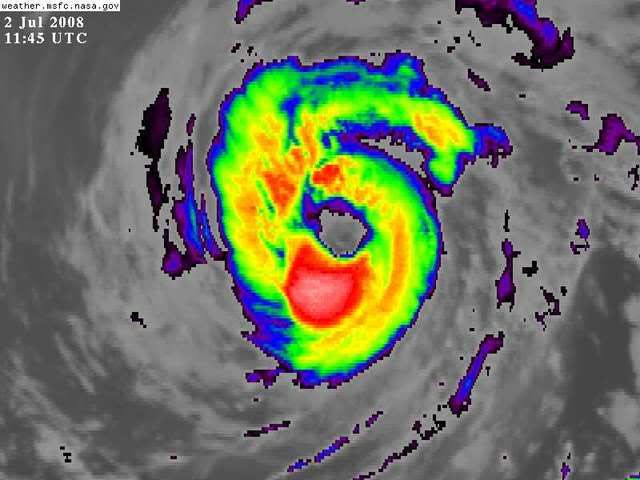
Date : 02 JUL 2008 Time : 103000 UTC
Lat : 16:08:37 N Lon : 126:42:07 W
CI# /Pressure/ Vmax
5.1 / 970.4mb/ 92.4kt
Final T# Adj T# Raw T#
(3hr avg)
5.1 5.1 5.1
Latitude bias adjustment to MSLP : +2.4mb
Estimated radius of max. wind based on IR : 40 km
Center Temp : +11.2C Cloud Region Temp : -52.8C
Scene Type : EYE
Positioning Method : SPIRAL ANALYSIS
Ocean Basin : EAST PACIFIC
Dvorak CI > MSLP Conversion Used : ATLANTIC
Tno/CI Rules : Constraint Limits : NO LIMIT
Weakening Flag : OFF
Rapid Dissipation Flag : OFF
****************************************************
ADVANCED DVORAK TECHNIQUE
ADT-Version 7.2.3
Tropical Cyclone Intensity Algorithm
----- Current Analysis -----
Date : 02 JUL 2008 Time : 103000 UTC
Lat : 16:08:37 N Lon : 126:42:07 W
CI# /Pressure/ Vmax
5.1 / 970.4mb/ 92.4kt
Final T# Adj T# Raw T#
(3hr avg)
5.1 5.1 5.1
Latitude bias adjustment to MSLP : +2.4mb
Estimated radius of max. wind based on IR : 40 km
Center Temp : +11.2C Cloud Region Temp : -52.8C
Scene Type : EYE
Positioning Method : SPIRAL ANALYSIS
Ocean Basin : EAST PACIFIC
Dvorak CI > MSLP Conversion Used : ATLANTIC
Tno/CI Rules : Constraint Limits : NO LIMIT
Weakening Flag : OFF
Rapid Dissipation Flag : OFF
****************************************************
0 likes


Saying that though the convection isn't shallow either, esp on the southern side of the eyewall there is some decently deep convection.
The northern eyewall has also gotten stronger recently as well which has probably helped this system get a higher rating.
wonder what the NHC will do, wouldn't be all that surprising to see this upto a category 2 hurricane though would it given its current structure and the eye has stayed this time and not gone like previous days.
0 likes

EP, 02, 2008070212, , BEST, 0, 163N, 1269W, 65, 988, HU, 34, NEQ, 60, 75, 75, 60, 1012, 250, 20, 0, 0, E, 0, , 0, 0, BORIS, D,
EP, 02, 2008070212, , BEST, 0, 163N, 1269W, 65, 988, HU, 50, NEQ, 30, 40, 40, 30, 1012, 250, 20, 0, 0, E, 0, , 0, 0, BORIS, D,
EP, 02, 2008070212, , BEST, 0, 163N, 1269W, 65, 988, HU, 64, NEQ, 20, 25, 25, 20, 1012, 250, 20, 0, 0, E, 0, , 0, 0, BORIS, D,
Held at 65 kts.
EP, 02, 2008070212, , BEST, 0, 163N, 1269W, 65, 988, HU, 50, NEQ, 30, 40, 40, 30, 1012, 250, 20, 0, 0, E, 0, , 0, 0, BORIS, D,
EP, 02, 2008070212, , BEST, 0, 163N, 1269W, 65, 988, HU, 64, NEQ, 20, 25, 25, 20, 1012, 250, 20, 0, 0, E, 0, , 0, 0, BORIS, D,
Held at 65 kts.
0 likes
-
Ed Mahmoud
Re: Hurricane Boris in EPAC
Going back to what Derek was saying yesterday, is this becoming annular? How much of what appears to be banding actually is banding, as compared to outflow channels?
Not quite a truck tire yet, but it sort of looks like it is heading in that direction.
Not quite a truck tire yet, but it sort of looks like it is heading in that direction.
0 likes
Re: Hurricane Boris in EPAC
Ed Mahmoud wrote:Going back to what Derek was saying yesterday, is this becoming annular?
## ANNULAR HURRICANE INDEX (AHI) EP022008 BORIS 07/02/08 12 UTC ##
## STORM NOT ANNULAR, SCREENING STEP FAILED, NPASS=6 NFAIL=1 ##
## AHI= 0 (AHI OF 100 IS BEST FIT TO ANN. STRUC., 1 IS MARGINAL, 0 IS NOT ANNULAR) ##
## ANNULAR INDEX RAN NORMALLY
0 likes

-
Ed Mahmoud
Re: Hurricane Boris in EPAC
Chacor wrote:Ed Mahmoud wrote:Going back to what Derek was saying yesterday, is this becoming annular?
## ANNULAR HURRICANE INDEX (AHI) EP022008 BORIS 07/02/08 12 UTC ##
## STORM NOT ANNULAR, SCREENING STEP FAILED, NPASS=6 NFAIL=1 ##
## AHI= 0 (AHI OF 100 IS BEST FIT TO ANN. STRUC., 1 IS MARGINAL, 0 IS NOT ANNULAR) ##
## ANNULAR INDEX RAN NORMALLY
Thanks.
0 likes
Who is online
Users browsing this forum: No registered users and 117 guests