

90W Invest: TD from JMA
Moderator: S2k Moderators
90W Invest: TD from JMA
Way out there about 700 miles east of Guam.
Last edited by RL3AO on Sun Jul 06, 2008 8:42 am, edited 1 time in total.
0 likes


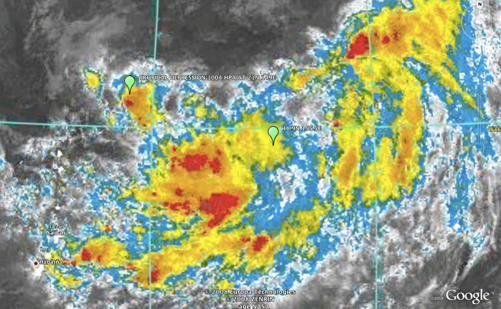
TROPICAL DEPRESSION 1004 HPA AT 21N 149E EAST SLOWLY
----
(2) AN AREA OF CONVECTION HAS PERSISTED NEAR 19.0N 154.8E,
APPROXIMATELY 690 NM EAST-NORTHEAST OF GUAM. ANIMATED MULTISPECTRAL
SATELLITE IMAGERY AND A DETAILED SURFACE ANALYSIS INDICATE A
DEVELOPING MONSOON GYRE EVIDENCED BY A RELATIVELY LARGE CYCLONIC
CIRCULATION POSITIONED EAST OF A NORTH-SOUTH ORIENTED RIDGE. WITHIN
THIS GYRE, THERE ARE AT LEAST 3 LOW-LEVEL CIRCULATION CENTERS (LLCC)
AND A CLASSIC FISH-HOOK PATTERN OF DEEP CONVECTION FORMING ALONG THE
SOUTHEAST AND EASTERN PERIPHERY. IMAGERY DEPICTS A LARGE AREA OF
PERSISTENT CONVECTION WITH A POORLY-ORGANIZED CONVECTION. A 060306Z
AMSU IMAGE INDICATES A WEAK LLCC WITH CONVECTIVE BANDING OVER THE
SOUTHERN PERIPHERY. A 051927Z QUIKSCAT IMAGE SHOWED TIGHT TROUGHING
EXTENDING WEST INTO ANOTHER LLCC NEAR 21N 150E. THE LLCC IS LOCATED
WITHIN A FAVORABLE ENVIRONMENT UNDER THE SUBTROPICAL RIDGE AXIS WITH
SST NEAR 28C AND GOOD OUTFLOW. MAXIMUM SUSTAINED SURFACE WINDS ARE
ESTIMATED AT 10 TO 15 KNOTS. MINIMUM SEA LEVEL PRESSURE IS ESTIMATED
TO BE NEAR 1006 MB. THE POTENTIAL FOR THE DEVELOPMENT OF A
SIGNIFICANT TROPICAL CYCLONE WITHIN THE NEXT 24 HOURS IS POOR.
0 likes


Who is online
Users browsing this forum: No registered users and 11 guests