The latest best track by ATCF increases the winds to 90kts:
EP, 06, 2008071618, , BEST, 0, 169N, 1172W, 90, 970, HU, 64, NEQ, 15, 15, 15, 15, 1012, 270, 10, 0, 0,
EPAC: Tropical Depression Elida
Moderator: S2k Moderators
-
cycloneye

- Admin

- Posts: 139065
- Age: 67
- Joined: Thu Oct 10, 2002 10:54 am
- Location: San Juan, Puerto Rico
Re: EPAC: Hurricane Elida
0 likes

Re: EPAC: Hurricane Elida
cycloneye wrote:The latest best track by ATCF increases the winds to 90kts:
EP, 06, 2008071618, , BEST, 0, 169N, 1172W, 90, 970, HU, 64, NEQ, 15, 15, 15, 15, 1012, 270, 10, 0, 0,
Well...DUH!
0 likes
-
HurricaneHunter914
- Category 5

- Posts: 4439
- Age: 30
- Joined: Fri Mar 10, 2006 7:36 pm
- Location: College Station, TX


Look at how quickly the eye moves from the west edge to the center (aka convection develops/wraps around).
http://rammb.cira.colostate.edu/products/tc_realtime/4kmirimg_loop.asp?storm_identifier=EP062008&starting_image=2008EP06_4KMIRIMG_200807120345.GIF
http://rammb.cira.colostate.edu/products/tc_realtime/4kmirimg_loop.asp?storm_identifier=EP062008&starting_image=2008EP06_4KMIRIMG_200807120345.GIF
0 likes
-
Squarethecircle
- Category 5
- Posts: 2165
- Joined: Fri Oct 19, 2007 4:00 pm
- Location: Fairfax, VA

Code: Select all
                      UW - CIMSS
              ADVANCED DVORAK TECHNIQUE
                  ADT-Version 7.2.3
         Tropical Cyclone Intensity Algorithm

             ----- Current Analysis -----
     Date :  16 JUL 2008    Time :   173000 UTC
      Lat :   16:50:45 N     Lon :  117:08:35 W


                CI# /Pressure/ Vmax
                3.9 / 990.6mb/ 63.0kt


             Final T#  Adj T#  Raw T#
             (3hr avg)
                3.9     4.2     6.0

     Latitude bias adjustment to MSLP :  +2.2mb

 Estimated radius of max. wind based on IR : 11 km

 Center Temp : -32.6C    Cloud Region Temp : -67.9C

 Scene Type : EYE
Raw t number of 6.0, which supports 115 kts. I doubt it's quite that high but it does seem like it is intensifying rapidly... and the water's not even that warm
0 likes


-
cycloneye
- Admin
- Posts: 139065
- Age: 67
- Joined: Thu Oct 10, 2002 10:54 am
- Location: San Juan, Puerto Rico
Re: EPAC: Hurricane Elida
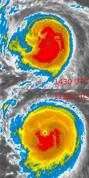
357
WTPZ41 KNHC 162026
TCDEP1
HURRICANE ELIDA DISCUSSION NUMBER 20
NWS TPC/NATIONAL HURRICANE CENTER MIAMI FL EP062008
200 PM PDT WED JUL 16 2008
VISIBLE SATELLITE IMAGES REVEAL THAT ELIDA HAS DEVELOPED AN EYE
EMBEDDED WITHIN A ROUND CENTRAL DENSE OVERCAST. CONSEQUENTLY...
T-NUMBERS INCREASED TO 5.0 ON THE DVORAK SCALE WITH OBJECTIVE
T-NUMBERS A LITTLE BIT HIGHER. INITIAL INTENSITY HAS BEEN ADJUSTED
UPWARD TO 90 KNOTS. ELIDA IS VERY NEAR COOLER WATERS...SO THIS
COULD BE THE PEAK INTENSITY OF THE CYCLONE. A GRADUAL WEAKENING IS
EXPECTED TO BEGIN SOON.
ELIDA IS MOVING TOWARD THE WEST OR 275 DEGREES AT 12 KNOTS. THE
HURRICANE CONTINUES TO MOVE SOUTH OF A STRONG EAST-WEST ORIENTED
SUBTROPICAL RIDGE AXIS. THIS PATTERN IS FORECAST TO PERSIST AND
SHOULD FORCE ELIDA ON A GENERAL WESTWARD TRACK THROUGH 5 DAYS. THE
OFFICIAL FORECAST IS IN THE MIDDLE OF THE GUIDANCE ENVELOPE.
FORECAST POSITIONS AND MAX WINDS
INITIAL 16/2100Z 17.0N 117.8W 90 KT
12HR VT 17/0600Z 17.3N 119.6W 80 KT
24HR VT 17/1800Z 17.7N 122.1W 70 KT
36HR VT 18/0600Z 18.0N 125.0W 60 KT
48HR VT 18/1800Z 18.0N 127.5W 45 KT
72HR VT 19/1800Z 18.0N 132.5W 30 KT
96HR VT 20/1800Z 18.0N 137.5W 25 KT...REMNANT LOW
120HR VT 21/1800Z 18.0N 142.0W 20 KT...REMNANT LOW
$$
FORECASTER AVILA
0 likes


Who is online
Users browsing this forum: No registered users and 92 guests