WPAC: TS Kalmaegi (JTWC: TS 08W)

Moderator: S2k Moderators

Message
Author
Typhoon Hunter
WesternPacificWeather.com
Posts: 1215
Age: 40
Joined: Wed Oct 11, 2006 11:37 am
Location: Hong Kong
Contact:

Re: WPAC: TS Kalmaegi (JTWC: TD 08W, PAGASA: TS Helen)

#41 Postby Typhoon Hunter » Tue Jul 15, 2008 9:24 am

Well Shanghai is certainly with the cone of uncertainty at the moment so I though I'd post a comparison of what the regional agencies are forecasting at the moment. As Chacor just said JMA have now upped Kalmaegi (from now on KM since it's hard to type) to 40kts.

JMA, HKO, CWB and Pagasa are all going for a similar track at the moment. JTWC have swung more poleward in their latest warning #6 but are still the most westerly of all forecasts at the moment.

Here's the 12z JMA track which suggest Zhejiang/Shanghai area could be at risk:
Image

And here's the 09z track from HKO, similar to what JMA are forecasting:
Image

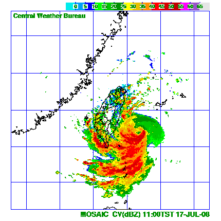
And a similar scene from CWB at 12z:
Image

And Pagasa who originally were predicting a westerly track have swung to the north in their 09z update:
Image

And finally the most western track of them all the 12z from JTWC, it still blobs a tropical depression over me at the weekend!
Image

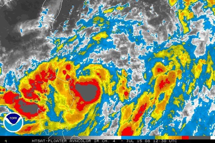
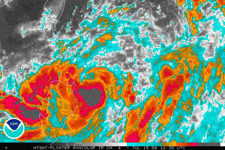
It's certainly shaping up to be a very interesting week tracking Kalmaegi.
Mods if I've posted too many pics or they're too large for the forum please let me know and I'll zap them. Cheers.
Last edited by Typhoon Hunter on Tue Jul 15, 2008 9:34 am, edited 1 time in total.
0 likes   

User avatar
Chacor
Category 5
Category 5
Posts: 10229
Joined: Mon Oct 02, 2006 10:43 pm
Location: Singapore

#42 Postby Chacor » Tue Jul 15, 2008 9:28 am

Original:
Image

Colour-edited with noise:
Image
0 likes   

User avatar
KWT
Category 5
Category 5
Posts: 31390
Joined: Tue Aug 17, 2004 11:02 am
Location: UK!!!

#43 Postby KWT » Tue Jul 15, 2008 12:57 pm

Looking decent right now, I was wondering when the WPAC would pump out its next system. Anyway its got nice deep convection as evidenced by the IR images in this thread, I see no reason why this won't strengthen unless it gets too close to land.
0 likes   

User avatar
HURAKAN
Professional-Met
Professional-Met
Posts: 46086
Age: 37
Joined: Thu May 20, 2004 4:34 pm
Location: Key West, FL
Contact:

#44 Postby HURAKAN » Tue Jul 15, 2008 6:19 pm

15/2057 UTC 18.5N 123.7E T3.5/3.5 KALMAEGI -- West Pacific Ocean
0 likes   

User avatar
KWT
Category 5
Category 5
Posts: 31390
Joined: Tue Aug 17, 2004 11:02 am
Location: UK!!!

#45 Postby KWT » Tue Jul 15, 2008 6:22 pm

Hmmm 3.5, thats pretty impressive that supports a pretty strong tropical storm. I thinkits strength at least in the next 24hrs will be totally dictated by how close it gets to land in that time period.
0 likes   

User avatar
Chacor
Category 5
Category 5
Posts: 10229
Joined: Mon Oct 02, 2006 10:43 pm
Location: Singapore

#46 Postby Chacor » Tue Jul 15, 2008 7:03 pm

TCNA21 RJTD 160000
CCAA 16000 47644 KALMAEGI(0807) 11188 11238 13234 230// 90310=

T3.0 from JMA.
0 likes   

User avatar
Chacor
Category 5
Category 5
Posts: 10229
Joined: Mon Oct 02, 2006 10:43 pm
Location: Singapore

#47 Postby Chacor » Tue Jul 15, 2008 7:52 pm

WTPQ20 RJTD 160000
RSMC TROPICAL CYCLONE ADVISORY
NAME TS 0807 KALMAEGI (0807)
ANALYSIS
PSTN 160000UTC 18.5N 123.5E FAIR
MOVE NNE SLOWLY
PRES 990HPA
MXWD 045KT
GUST 065KT
30KT 120NM EAST 100NM WEST
FORECAST
24HF 170000UTC 21.8N 123.0E 70NM 70%
MOVE N 08KT
PRES 980HPA
MXWD 055KT
GUST 080KT
48HF 180000UTC 25.2N 122.7E 160NM 70%
MOVE N 09KT
PRES 970HPA
MXWD 065KT
GUST 095KT
72HF 190000UTC 29.1N 123.1E 220NM 70%
MOVE N 10KT
PRES 965HPA
MXWD 070KT
GUST 100KT =

JMA calling for a typhoon in two days.
0 likes   

User avatar
RattleMan
Category 5
Category 5
Posts: 1218
Joined: Wed Aug 24, 2005 7:14 pm
Location: Phoenix, AZ

Re: WPAC: Tropical Storm Kalmaegi (PAGASA: TS Helen)

#48 Postby RattleMan » Wed Jul 16, 2008 2:16 am

WTPQ20 RJTD 160600
RSMC TROPICAL CYCLONE ADVISORY
NAME STS 0807 KALMAEGI (0807) UPGRADED FROM TS
ANALYSIS
PSTN 160600UTC 19.2N 123.5E FAIR
MOVE N 07KT
PRES 985HPA
MXWD 050KT
GUST 070KT
30KT 130NM EAST 110NM WEST
FORECAST
24HF 170600UTC 22.7N 123.0E 70NM 70%
MOVE N 09KT
PRES 975HPA
MXWD 060KT
GUST 085KT
48HF 180600UTC 26.5N 123.0E 160NM 70%
MOVE N 10KT
PRES 960HPA
MXWD 075KT
GUST 105KT
72HF 190600UTC 30.3N 123.7E 220NM 70%
MOVE N 10KT
PRES 955HPA
MXWD 075KT
GUST 105KT =
0 likes   

Typhoon Hunter
WesternPacificWeather.com
Posts: 1215
Age: 40
Joined: Wed Oct 11, 2006 11:37 am
Location: Hong Kong
Contact:

Re: WPAC: Tropical Storm Kalmaegi (PAGASA: TS Helen)

#49 Postby Typhoon Hunter » Wed Jul 16, 2008 2:47 am

Kalmaegi now a Severe Tropical storm and JMA have up max intensity to 75kts later in the forecast period. Still forecast to brush east coast of Taiwan.
0 likes   

Typhoon Hunter
WesternPacificWeather.com
Posts: 1215
Age: 40
Joined: Wed Oct 11, 2006 11:37 am
Location: Hong Kong
Contact:

Re: WPAC: Tropical Storm Kalmaegi (PAGASA: TS Helen)

#50 Postby Typhoon Hunter » Wed Jul 16, 2008 3:51 am

CWB are now issuing detailed warnings on Kalmaegi and they'll issue these every 3 hours.

Visit http://www.cwb.gov.tw/V5e/index.htm and click on Typhoon Warning in top left hand corner.
0 likes   

User avatar
Chacor
Category 5
Category 5
Posts: 10229
Joined: Mon Oct 02, 2006 10:43 pm
Location: Singapore

#51 Postby Chacor » Wed Jul 16, 2008 8:03 am

WTPQ20 RJTD 161200
RSMC TROPICAL CYCLONE ADVISORY
NAME STS 0807 KALMAEGI (0807)
ANALYSIS
PSTN 161200UTC 20.5N 123.6E FAIR
MOVE N 13KT
PRES 985HPA
MXWD 055KT
GUST 080KT
50KT 40NM
30KT 150NM SOUTHEAST 120NM NORTHWEST
FORECAST
24HF 171200UTC 24.7N 123.0E 75NM 70%
MOVE N 11KT
PRES 965HPA
MXWD 070KT
GUST 100KT
48HF 181200UTC 28.8N 123.0E 160NM 70%
MOVE N 10KT
PRES 955HPA
MXWD 075KT
GUST 105KT
72HF 191200UTC 32.4N 125.2E 220NM 70%
MOVE NNE 10KT
PRES 955HPA
MXWD 075KT
GUST 105KT =
0 likes   

User avatar
Chacor
Category 5
Category 5
Posts: 10229
Joined: Mon Oct 02, 2006 10:43 pm
Location: Singapore

#52 Postby Chacor » Wed Jul 16, 2008 10:52 am

WTPQ20 RJTD 161500
RSMC TROPICAL CYCLONE ADVISORY
NAME STS 0807 KALMAEGI (0807)
ANALYSIS
PSTN 161500UTC 21.2N 123.4E FAIR
MOVE N 17KT
PRES 985HPA
MXWD 055KT
GUST 080KT
50KT 40NM
30KT 150NM SOUTHEAST 120NM NORTHWEST
FORECAST
24HF 171500UTC 25.1N 122.4E 75NM 70%
MOVE N 10KT
PRES 965HPA
MXWD 070KT
GUST 100KT
45HF 181200UTC 28.8N 123.0E 160NM 70%
MOVE N 10KT
PRES 955HPA
MXWD 075KT
GUST 105KT
69HF 191200UTC 32.4N 125.2E 220NM 70%
MOVE NNE 10KT
PRES 955HPA
MXWD 075KT
GUST 105KT =
0 likes   

Ed Mahmoud

Re: WPAC: Tropical Storm Kalmaegi (PAGASA: TS Helen)

#53 Postby Ed Mahmoud » Wed Jul 16, 2008 11:59 am

Typhoon Hunter wrote:Kalmaegi now a Severe Tropical storm and JMA have up max intensity to 75kts later in the forecast period. Still forecast to brush east coast of Taiwan.


You flying to Taiwan by any chance?
0 likes   

User avatar
RattleMan
Category 5
Category 5
Posts: 1218
Joined: Wed Aug 24, 2005 7:14 pm
Location: Phoenix, AZ

Re: WPAC: Tropical Storm Kalmaegi (PAGASA: TS Helen)

#54 Postby RattleMan » Wed Jul 16, 2008 3:23 pm

WTPQ20 RJTD 161800
RSMC TROPICAL CYCLONE ADVISORY
NAME STS 0807 KALMAEGI (0807)
ANALYSIS
PSTN 161800UTC 21.4N 123.3E FAIR
MOVE NNW 09KT
PRES 980HPA
MXWD 060KT

GUST 085KT
50KT 45NM
30KT 160NM SOUTHEAST 130NM NORTHWEST
FORECAST
24HF 171800UTC 25.3N 122.1E 70NM 70%
MOVE N 10KT
PRES 965HPA
MXWD 070KT
GUST 100KT
48HF 181800UTC 28.9N 122.0E 160NM 70%
MOVE N 10KT
PRES 960HPA
MXWD 075KT
GUST 105KT
72HF 191800UTC 32.7N 124.9E 250NM 70%
MOVE NNE 11KT
PRES 960HPA
MXWD 075KT
GUST 105KT =
0 likes   

User avatar
KWT
Category 5
Category 5
Posts: 31390
Joined: Tue Aug 17, 2004 11:02 am
Location: UK!!!

#55 Postby KWT » Wed Jul 16, 2008 3:28 pm

Looks like its close now to being upgraded, very impressive looking system. Really large are aof deep convection with this system right now, probably will strengthen pretty rapidly now.
0 likes   

SkyDragon

Re:

#56 Postby SkyDragon » Wed Jul 16, 2008 6:53 pm

Not common for JTWC to have it as a TD when JMA already have it as a storm.

The Last Kalmaegi was a TD by the JTWC!! But that was yesterday.
0 likes   

User avatar
Chacor
Category 5
Category 5
Posts: 10229
Joined: Mon Oct 02, 2006 10:43 pm
Location: Singapore

#57 Postby Chacor » Wed Jul 16, 2008 7:26 pm

T-numbers have shot up.

TCNA21 RJTD 170000
CCAA 17000 47644 KALMAEGI(0807) 11225 11228 12344 245// 93411=

Should have a typhoon.
0 likes   

Typhoon Hunter
WesternPacificWeather.com
Posts: 1215
Age: 40
Joined: Wed Oct 11, 2006 11:37 am
Location: Hong Kong
Contact:

Re: WPAC: STS Kalmaegi (PAGASA: TS Helen)

#58 Postby Typhoon Hunter » Wed Jul 16, 2008 7:30 pm

Hi Ed.

I won't be flying to Taiwan for this since I'm in Shanghai at the moment and it could be passing very close to the city. I think JMA are doing hourly updates now.
0 likes   

User avatar
Chacor
Category 5
Category 5
Posts: 10229
Joined: Mon Oct 02, 2006 10:43 pm
Location: Singapore

#59 Postby Chacor » Wed Jul 16, 2008 7:56 pm

Straight to 70 kts.

WTPQ20 RJTD 170000
RSMC TROPICAL CYCLONE ADVISORY
NAME TY 0807 KALMAEGI (0807) UPGRADED FROM STS
ANALYSIS
PSTN 170000UTC 22.4N 122.9E FAIR
MOVE NNW 11KT
PRES 970HPA
MXWD 070KT
GUST 100KT
50KT 50NM
30KT 160NM SOUTHEAST 120NM NORTHWEST
FORECAST
24HF 180000UTC 26.1N 121.4E 70NM 70%
MOVE NNW 10KT
PRES 960HPA
MXWD 075KT
GUST 105KT
48HF 190000UTC 29.7N 121.8E 160NM 70%
MOVE N 09KT
PRES 960HPA
MXWD 075KT
GUST 105KT
72HF 200000UTC 33.0N 124.0E 220NM 70%
MOVE NNE 09KT
PRES 970HPA
MXWD 065KT
GUST 095KT =
0 likes   

User avatar
HURAKAN
Professional-Met
Professional-Met
Posts: 46086
Age: 37
Joined: Thu May 20, 2004 4:34 pm
Location: Key West, FL
Contact:

#60 Postby HURAKAN » Wed Jul 16, 2008 10:17 pm

0 likes   


Return to “2008”

Who is online

Users browsing this forum: No registered users and 118 guests