
BEGIN
NHC
invest_al962008.invest
FSTDA
R
U
040
010
0000
200807171829
NONE
NOTIFY=ATRP
END
INVEST, AL, L, , , , , 96, 2008, DB, O, 2008071718, 9999999999, , , , , , METWATCH, , AL962008
AL, 96, 2008071700, , BEST, 0, 290N, 805W, 15, 1013, DB, 0, , 0, 0, 0, 0,
AL, 96, 2008071706, , BEST, 0, 295N, 805W, 15, 1013, DB, 0, , 0, 0, 0, 0,
AL, 96, 2008071712, , BEST, 0, 301N, 805W, 15, 1013, DB, 0, , 0, 0, 0, 0,
AL, 96, 2008071718, , BEST, 0, 305N, 803W, 20, 1013, DB, 34, NEQ, 0, 0, 0, 0, 1015, 80, 60, 0, 0, L, 0, , 0, 0, INVEST, M,
ATL: Tropical Storm Cristobal in North Atlantic
Moderator: S2k Moderators
-
'CaneFreak

- Category 5

- Posts: 1475
- Joined: Mon Jun 05, 2006 10:50 am
- Location: New Bern, NC
-
tolakram
- Admin

- Posts: 19165
- Age: 60
- Joined: Sun Aug 27, 2006 8:23 pm
- Location: Florence, KY (name is Mark)
Re: ATL: INVEST 96L near Southeast US
Yea, I see they upgraded the area to orange and now say development is possible. Talk about a sea change (pun intended). 

ZCZC MIATWOAT ALL
TTAA00 KNHC DDHHMM
TROPICAL WEATHER OUTLOOK
NWS TPC/NATIONAL HURRICANE CENTER MIAMI FL
200 PM EDT THU JUL 17 2008
FOR THE NORTH ATLANTIC...CARIBBEAN SEA AND THE GULF OF MEXICO...
...
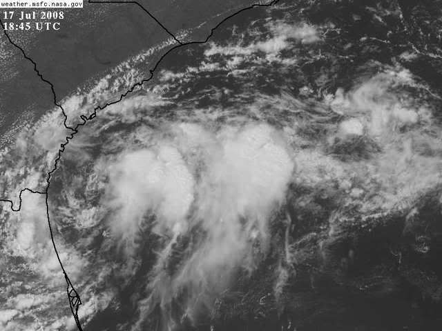
3. THUNDERSTORM ACTIVITY HAS INCREASED NEAR A LOW PRESSURE SYSTEM
LOCATED ABOUT 75 MILES EAST OF JACKSONVILLE FLORIDA. ENVIRONMENTAL
CONDITIONS COULD ALLOW FOR SOME SLOW DEVELOPMENT OF THIS SYSTEM
DURING THE NEXT COUPLE OF DAYS AS THE LOW DRIFTS TO THE NORTH OR
NORTH-NORTHEAST.
ELSEWHERE...TROPICAL CYCLONE FORMATION IS NOT EXPECTED DURING THE
NEXT 48 HOURS.
$$
FORECASTER BLAKE/KNABB
ZCZC MIATWOAT ALL
TTAA00 KNHC DDHHMM
TROPICAL WEATHER OUTLOOK
NWS TPC/NATIONAL HURRICANE CENTER MIAMI FL
200 PM EDT THU JUL 17 2008
FOR THE NORTH ATLANTIC...CARIBBEAN SEA AND THE GULF OF MEXICO...
...
3. THUNDERSTORM ACTIVITY HAS INCREASED NEAR A LOW PRESSURE SYSTEM
LOCATED ABOUT 75 MILES EAST OF JACKSONVILLE FLORIDA. ENVIRONMENTAL
CONDITIONS COULD ALLOW FOR SOME SLOW DEVELOPMENT OF THIS SYSTEM
DURING THE NEXT COUPLE OF DAYS AS THE LOW DRIFTS TO THE NORTH OR
NORTH-NORTHEAST.
ELSEWHERE...TROPICAL CYCLONE FORMATION IS NOT EXPECTED DURING THE
NEXT 48 HOURS.
$$
FORECASTER BLAKE/KNABB
0 likes
-
WeatherWiseGuy
- Tropical Depression

- Posts: 92
- Joined: Sat Jul 23, 2005 7:48 pm
- Location: Florida
Re: ATL: INVEST 96L near Southeast US
Circulation is easy to see on Jax radar: http://radar.weather.gov/radar.php?rid= ... 1&loop=yes
0 likes


-
senorpepr

- Military Met/Moderator

- Posts: 12542
- Age: 41
- Joined: Fri Aug 22, 2003 9:22 pm
- Location: Mackenbach, Germany
- Contact:
Tropical Storm Cristobal Weather Charts
Ensure you've refreshed for the latest maps!
Updates hourly at :30
Tropical Storm Cristobal (03L)
Surface Pressure and Plots

Surface Streamlines and Plots

Sea Surface Temperatures

Updates hourly at :30
Tropical Storm Cristobal (03L)
Surface Pressure and Plots
Surface Streamlines and Plots
Sea Surface Temperatures
0 likes


-
brunota2003

- S2K Supporter

- Posts: 9476
- Age: 33
- Joined: Sat Jul 30, 2005 9:56 pm
- Location: Stanton, KY...formerly Havelock, NC
- Contact:
-
HarlequinBoy

- Category 5
- Posts: 1400
- Age: 33
- Joined: Wed Nov 29, 2006 1:57 am
- Location: Memphis

-
brunota2003
- S2K Supporter
- Posts: 9476
- Age: 33
- Joined: Sat Jul 30, 2005 9:56 pm
- Location: Stanton, KY...formerly Havelock, NC
- Contact:
And encase you all missed it:
EATHER RECONNAISSANCE FLIGHTS
CARCAH, NATIONAL HURRICANE CENTER, MIAMI, FL.
1130 AM EDT THU 17 JULY 2008
SUBJECT: TROPICAL CYCLONE PLAN OF THE DAY (TCPOD)
VALID 18/1100Z TO 19/1100Z JULY 2008
TCPOD NUMBER.....08-047 CORRECTION
I. ATLANTIC REQUIREMENTS
1. SUSPECT AREA...(CARIBBEAN SEA)
FLIGHT ONE -- TEAL 70 (NO CHANGE)
A. 18/1800Z
B. AFXXX 04AAA CYCLONE
C. 18/1445Z
D. 13.5N 73.0W
E. 18/1700Z TO 18/2030Z
F. SFC TO 10,000 FT
FLIGHT TWO -- TEAL 71 (CORRECTED)
A. 19/0600Z
B. AFXXX 05AAA CYCLONE
C. 19/0200Z........(CORRECTED FOR DATE)
D. 14.0N 76.5W
E. 19/0500Z TO 17/0830Z
F. SFC TO 10,000 FT
2. SUCCEEDING DAY OUTLOOK:
A. BEGIN 6 HRLY FIXES ON CARIBBEAN SYSTEM AT 19/1800Z.
B. POSSIBLE MISSION INTO W ATLANTIC SYSTEM AT 32.5N
78.0W FOR 19/1800Z.
0 likes

Re: ATL: INVEST 96L near Southeast US
Dang! Looks like the Atlantic is trying to catch up with the EPAC in short order!
I've been watching this spin for two days now. Dumped a lot of rain on us. I sure hope it doesn't get together and cause anyone big problems!
I've been watching this spin for two days now. Dumped a lot of rain on us. I sure hope it doesn't get together and cause anyone big problems!
0 likes
-
brunota2003
- S2K Supporter
- Posts: 9476
- Age: 33
- Joined: Sat Jul 30, 2005 9:56 pm
- Location: Stanton, KY...formerly Havelock, NC
- Contact:
Re:
RL3AO wrote:Saturday might be too late.
If it does develop, I think you'll see that date shift in a hurry...especially if it looks like it'll hit anywhere.
0 likes
-
HurricaneHunter914
- Category 5
- Posts: 4439
- Age: 30
- Joined: Fri Mar 10, 2006 7:36 pm
- Location: College Station, TX
-
storms in NC

- S2K Supporter
- Posts: 2338
- Joined: Thu Jul 28, 2005 2:58 pm
- Location: Wallace,NC 40 miles NE of Wilm
- Contact:
I say Welcome to N.C. Most wanted rain the farms need. A nice TD with little wind. Come on and see us and you gift of rain.
But I really need to watch this my Family is leaving Friday for Ft Myers for a wedding. I am broke or I'd be with them. They will take I 95 all the way down.
It will be a ruff ride to say.
But I really need to watch this my Family is leaving Friday for Ft Myers for a wedding. I am broke or I'd be with them. They will take I 95 all the way down.
It will be a ruff ride to say.
0 likes
-
storms in NC
- S2K Supporter
- Posts: 2338
- Joined: Thu Jul 28, 2005 2:58 pm
- Location: Wallace,NC 40 miles NE of Wilm
- Contact:
Re:
brunota2003 wrote:And encase you all missed it:
EATHER RECONNAISSANCE FLIGHTS
CARCAH, NATIONAL HURRICANE CENTER, MIAMI, FL.
1130 AM EDT THU 17 JULY 2008
SUBJECT: TROPICAL CYCLONE PLAN OF THE DAY (TCPOD)
VALID 18/1100Z TO 19/1100Z JULY 2008
TCPOD NUMBER.....08-047 CORRECTION
I. ATLANTIC REQUIREMENTS
1. SUSPECT AREA...(CARIBBEAN SEA)
FLIGHT ONE -- TEAL 70 (NO CHANGE)
A. 18/1800Z
B. AFXXX 04AAA CYCLONE
C. 18/1445Z
D. 13.5N 73.0W
E. 18/1700Z TO 18/2030Z
F. SFC TO 10,000 FT
FLIGHT TWO -- TEAL 71 (CORRECTED)
A. 19/0600Z
B. AFXXX 05AAA CYCLONE
C. 19/0200Z........(CORRECTED FOR DATE)
D. 14.0N 76.5W
E. 19/0500Z TO 17/0830Z
F. SFC TO 10,000 FT
2. SUCCEEDING DAY OUTLOOK:
A. BEGIN 6 HRLY FIXES ON CARIBBEAN SYSTEM AT 19/1800Z.
B. POSSIBLE MISSION INTO W ATLANTIC SYSTEM AT 32.5N
78.0W FOR 19/1800Z.
I am at 34.9N 77.9W
0 likes
Who is online
Users browsing this forum: No registered users and 61 guests