EPAC: Tropical Storm Hernan
Moderator: S2k Moderators


Re:
KWT wrote:I think Hernan is probably now upto 75kts, it does look pretty solid cat-1 to me looking at the vis. imagery and with a little more strengthening could well be a cat-2 before too long IMO.
Hernan is at 75 knots currently.
0 likes

-
Mecklenburg
-
MiamiensisWx
Re: EPAC: Hurricane Hernan
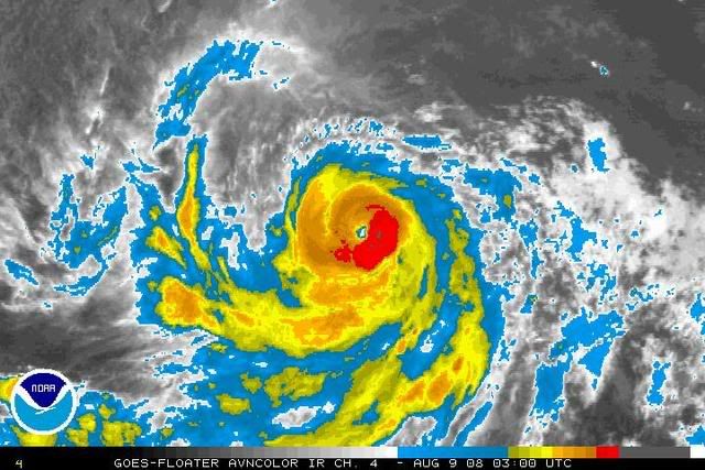
I've always been suspecting the original intensity forecast (70 kt) was too low. I believe that Category 2 intensity is very attainable. A weak upper low to the east has been providing excellent ventilation and a well defined southern outflow channel. An ideal diffluent environment and marginal shear has been present as well. Since the system has been moving just north of due west, it has stayed over the warmer SSTs/oceanic heat content with the best mid level moisture, unstable boundary layer, and instability. A well defined inner core (eye) and strong convection suggests that Hernan is approaching 85 kt. Visible data indicates the TC will have ~24 hours of intensification prior to encountering the stable thermodynamic environment/ML dry air (denoted by stratocumulus) to the north and west.
0 likes

Re:
HURAKAN wrote:08/1800 UTC 14.8N 120.3W T4.0/4.0 HERNAN -- East Pacific Ocean
4.0 makes no sence, Hernán is between 4.5 and 5.0.

Unless you are skilled in Dvorak analysis and have read Dvorak's paper, you can't tell just by looking at one visible.
0 likes
Re: EPAC: Hurricane Hernan
Mecklenburg wrote:has a good chance of becoming the first EPac major hurricane...
Anything to back that up, seeing how this is only 75 kt right now?
0 likes
-
HURAKAN

- Professional-Met

- Posts: 46086
- Age: 37
- Joined: Thu May 20, 2004 4:34 pm
- Location: Key West, FL
- Contact:
Re: Re:
Chacor wrote:Unless you are skilled in Dvorak analysis and have read Dvorak's paper, you can't tell just by looking at one visible.
You're quite right, I'm not an expert and I have not read Dvorak's paper, but I have seen many hurricanes and their corresponding Dvorak's classifications in my years of tracking cyclones. Therefore, it was of my opinion to say that based on the satellite image and Dvorak technique of images, Hernán was between 4.5 and 5. Interestingly the NHC said 75 knots, which is exactly 4.5, not 4.0.

Note: I went to read Dvorak's paper to make the explanation. Thanks!
Link: http://ams.allenpress.com/archive/1520- ... -5-420.pdf
0 likes
-
HURAKAN
- Professional-Met
- Posts: 46086
- Age: 37
- Joined: Thu May 20, 2004 4:34 pm
- Location: Key West, FL
- Contact:
772
WTPZ34 KNHC 090231
TCPEP4
BULLETIN
HURRICANE HERNAN ADVISORY NUMBER 10
NWS TPC/NATIONAL HURRICANE CENTER MIAMI FL EP092008
800 PM PDT FRI AUG 08 2008
...HERNAN STRENGTHENS A LITTLE MORE...
AT 800 PM PDT...0300 UTC...THE CENTER OF HURRICANE HERNAN WAS
LOCATED NEAR LATITUDE 15.1 NORTH...LONGITUDE 121.7 WEST OR ABOUT 940
MILES...1515 KM...WEST-SOUTHWEST OF THE SOUTHERN TIP OF BAJA
CALIFORNIA.
HERNAN IS MOVING TOWARD THE WEST-NORTHWEST NEAR 12 MPH...19 KM/HR...
AND THIS GENERAL MOTION IS EXPECTED TO CONTINUE DURING THE NEXT
COUPLE OF DAYS.
MAXIMUM SUSTAINED WINDS HAVE INCREASED TO NEAR 90 MPH...150 KM/HR...
WITH HIGHER GUSTS. SOME ADDITIONAL STRENGTHENING IS POSSIBLE
TONIGHT...FOLLOWED BY A GRADUAL WEAKENING THEREAFTER.
HURRICANE FORCE WINDS EXTEND OUTWARD UP TO 30 MILES...45 KM...FROM
THE CENTER...AND TROPICAL STORM FORCE WINDS EXTEND OUTWARD UP TO 105
MILES...165 KM.
ESTIMATED MINIMUM CENTRAL PRESSURE IS 977 MB...28.85 INCHES.
REPEATING THE 800 PM PDT POSITION...15.1 N...121.7 W. MOVEMENT
TOWARD...WEST-NORTHWEST NEAR 12 MPH. MAXIMUM SUSTAINED WINDS...90
MPH. MINIMUM CENTRAL PRESSURE...977 MB.
THE NEXT ADVISORY WILL BE ISSUED BY THE NATIONAL HURRICANE CENTER AT
200 AM PDT.
$$
FORECASTER BEVEN
0 likes


997
WTPZ44 KNHC 090845
TCDEP4
HURRICANE HERNAN DISCUSSION NUMBER 11
NWS TPC/NATIONAL HURRICANE CENTER MIAMI FL EP092008
200 AM PDT SAT AUG 09 2008
HERNAN'S SATELLITE PRESENTATION CONTINUES TO IMPROVE WITH DEEP
CONVECTION NOW A LITTLE MORE SYMMETRIC ABOUT THE EYE. THE INITIAL
INTENSITY IS INCREASED TO 85 KT WHICH IS CLOSE TO A CONSENSUS OF
THE VARIOUS SATELLITE INTENSITY ESTIMATES. HAVING SAID
THAT...HERNAN SHOULD BE AT OR VERY NEAR ITS PEAK INTENSITY AND
WEAKENING IS EXPECTED TO BEGIN WITHIN THE NEXT 12-24 HOURS AS THE
CYCLONE NEARS THE 26 DEGREE ISOTHERM. THE NEW OFFICIAL INTENSITY
FORECAST IS VERY SIMILAR TO THE PREVIOUS ONE AND SHOWS HERNAN
WEAKENING TO A TROPICAL STORM IN 36-48 HOURS. HERNAN COULD BE
NEARING REMNANT LOW STATUS IN 4 TO 5 DAYS.
HERNAN IS MOVING RIGHT ALONG THE PREVIOUS FORECAST TRACK WITH AN
INITIAL MOTION ESTIMATE OF 285/09. THIS GENERAL MOTION IS EXPECTED
TO CONTINUE FOR ANOTHER COUPLE OF DAYS AS A MID-LEVEL RIDGE REMAINS
NORTH OF HERNAN. BEYOND 48 HOURS...A TURN TO THE WEST OR EVEN
WEST-SOUTHWEST IS EXPECTED AS THE WEAKENING CYCLONE IS STEERED BY
THE SHALLOW TO MID-LEVEL FLOW. TRACK GUIDANCE HAS NOT CHANGED
SIGNIFICANTLY SINCE THE LAST ADVISORY AND ONLY MINOR ADJUSTMENTS TO
THE PREVIOUS FORECAST TRACK ARE NECESSARY AT THIS TIME.
FORECAST POSITIONS AND MAX WINDS
INITIAL 09/0900Z 15.5N 122.6W 85 KT
12HR VT 09/1800Z 15.8N 123.7W 80 KT
24HR VT 10/0600Z 16.5N 125.2W 75 KT
36HR VT 10/1800Z 17.0N 126.7W 70 KT
48HR VT 11/0600Z 17.3N 128.2W 60 KT
72HR VT 12/0600Z 17.5N 130.5W 50 KT
96HR VT 13/0600Z 17.5N 132.5W 40 KT
120HR VT 14/0600Z 16.5N 135.0W 30 KT
$$
FORECASTER RHOME
0 likes


-
Matt-hurricanewatcher

- Category 5

- Posts: 11649
- Age: 38
- Joined: Fri Nov 26, 2004 11:09 pm
- Location: Portland,OR
- Contact:
Re: EPAC: Hurricane Hernan
Possibly as high as 100 knots. But that may take some more take time. Anyways pretty good, hopefully this can become the first cat3.
0 likes
-
cycloneye

- Admin

- Posts: 139019
- Age: 67
- Joined: Thu Oct 10, 2002 10:54 am
- Location: San Juan, Puerto Rico
Re: EPAC: Hurricane Hernan
Here is the first major of 2008 in the EPAC:
WHXX01 KMIA 091305
CHGE77
TROPICAL CYCLONE GUIDANCE MESSAGE
NWS TPC/NATIONAL HURRICANE CENTER MIAMI FL
1305 UTC SAT AUG 9 2008
DISCLAIMER...NUMERICAL MODELS ARE SUBJECT TO LARGE ERRORS.
PLEASE REFER TO NHC OFFICIAL FORECASTS FOR TROPICAL CYCLONE
AND SUBTROPICAL CYCLONE INFORMATION.
EAST PACIFIC OBJECTIVE AIDS FOR
TROPICAL CYCLONE HERNAN (EP092008) 20080809 1200 UTC
...00 HRS... ...12 HRS... ...24 HRS. .. ...36 HRS...
080809 1200 080810 0000 080810 1200 080811 0000
LAT LON LAT LON LAT LON LAT LON
BAMS 15.5N 122.8W 16.5N 124.1W 17.4N 125.7W 18.1N 127.4W
BAMD 15.5N 122.8W 16.2N 124.6W 16.8N 126.3W 17.4N 128.0W
BAMM 15.5N 122.8W 16.6N 124.2W 17.4N 125.9W 18.3N 127.7W
LBAR 15.5N 122.8W 16.5N 124.5W 17.9N 126.3W 19.0N 128.2W
SHIP 100KTS 100KTS 91KTS 77KTS
DSHP 100KTS 100KTS 91KTS 77KTS
...48 HRS... ...72 HRS... ...96 HRS. .. ..120 HRS...
080811 1200 080812 1200 080813 1200 080814 1200
LAT LON LAT LON LAT LON LAT LON
BAMS 18.6N 129.2W 18.5N 132.8W 17.8N 136.2W 17.0N 140.0W
BAMD 17.7N 129.7W 17.6N 132.3W 16.8N 134.7W 15.8N 137.8W
BAMM 18.7N 129.6W 18.6N 133.1W 17.5N 136.2W 16.0N 139.8W
LBAR 19.9N 130.2W 21.3N 134.0W 22.1N 137.4W 23.2N 140.3W
SHIP 66KTS 52KTS 43KTS 40KTS
DSHP 66KTS 52KTS 43KTS 40KTS
...INITIAL CONDITIONS...
LATCUR = 15.5N LONCUR = 122.8W DIRCUR = 290DEG SPDCUR = 8KT
LATM12 = 14.9N LONM12 = 121.3W DIRM12 = 287DEG SPDM12 = 9KT
LATM24 = 14.6N LONM24 = 119.4W
WNDCUR = 100KT RMAXWD = 15NM WNDM12 = 75KT
CENPRS = 960MB OUTPRS = 1008MB OUTRAD = 250NM SDEPTH = D
RD34NE = 90NM RD34SE = 90NM RD34SW = 75NM RD34NW = 90NM
$$
0 likes
-
Squarethecircle
- Category 5
- Posts: 2165
- Joined: Fri Oct 19, 2007 4:00 pm
- Location: Fairfax, VA
Re: EPAC: Hurricane Hernan
Mecklenburg wrote:has a good chance of becoming the first EPac major hurricane...
So you got lucky.
0 likes
Who is online
Users browsing this forum: No registered users and 17 guests