WPac: TD KAMMURI (10W) - Over SE China
Moderator: S2k Moderators


-
Typhoon Hunter
- WesternPacificWeather.com

- Posts: 1215
- Age: 40
- Joined: Wed Oct 11, 2006 11:37 am
- Location: Hong Kong
- Contact:
Re: WPac: Trop. Depression (TD 10W, TD Julian) - South China Sea
Just on MSN to my friend who lives just north of Hong Kong. He just got nailed by that band, strong winds, lightning fest the full works. All quiet now. Looking at the Foshan city weather bureau website there were a few areas reporting gusts over 50kts.
0 likes
-
beaufort12
- S2K Supporter

- Posts: 70
- Joined: Thu Sep 02, 2004 9:18 am
- Location: Lorton VA
Re: WPac: Trop. Depression (TD 10W, TD Julian) - South China Sea
i'm just north of hong kong in shenzhen. first band of showers passed us by completely. i am sure i won't be able to say this tomorrow.
0 likes

Upgraded despite the T2.0. They must've had ground obs.
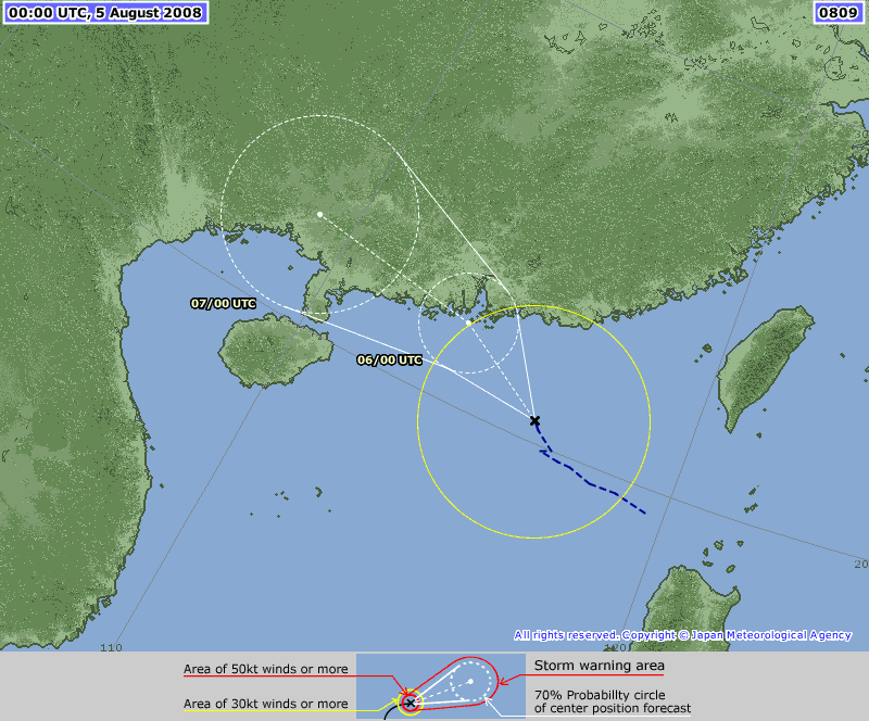
WTPQ20 RJTD 050000
RSMC TROPICAL CYCLONE ADVISORY
NAME TS 0809 KAMMURI (0809) UPGRADED FROM TD
ANALYSIS
PSTN 050000UTC 20.5N 116.2E POOR
MOVE WNW 07KT
PRES 992HPA
MXWD 035KT
GUST 050KT
30KT 160NM
FORECAST
24HF 060000UTC 21.9N 113.7E 70NM 70%
MOVE WNW 07KT
PRES 985HPA
MXWD 045KT
GUST 065KT
48HF 070000UTC 22.5N 109.0E 140NM 70% TROPICAL DEPRESSION =
0 likes
HKO:
Bulletin issued at 09:47 HKT 05/Aug/2008
Tropical Cyclone Bulletin
Here is the latest Tropical Cyclone Bulletin issued by the
Hong Kong Observatory.
The Standby Signal, No. 1 is in force.
This means that a tropical cyclone now centred within 800
kilometres of Hong Kong may affect us.
The tropical depression over the northern part of the South
China Sea has intensified into a tropical storm, and was
named Kammuri.
At 10 a.m., Kammuri was estimated to be about 300
kilometres southeast of Hong Kong (near 20.2 degrees north
116.0 degrees east) and is forecast to move west-northwest
at about 14 kilometres per hour towards the coastal areas
of Guangdong.
The tropical depression over the northern part of the South
China Sea has intensified into a tropical storm this
morning and was named Kammuri. According to the present
track, Kammuri will continue to edge towards the coast of
Guangdong and come closer to Hong Kong. Locally, winds are
expected to strengthen and Hong Kong is increasingly being
affected by the outer rainbands of Kammuri. The need for
the Strong Wind Signal No. 3 will be considered later this
afternoon or this evening.
0 likes

-
Matt-hurricanewatcher

- Category 5

- Posts: 11649
- Age: 38
- Joined: Fri Nov 26, 2004 11:09 pm
- Location: Portland,OR
- Contact:
Re: WPac: TS KAMMURI (10W/Julian) - South China Sea
Almost as good looking as the gulf storm. Lets see if this strengthens.
0 likes
-
beaufort12
- S2K Supporter
- Posts: 70
- Joined: Thu Sep 02, 2004 9:18 am
- Location: Lorton VA
Re: WPac: TS KAMMURI (10W/Julian) - South China Sea
it's been interesting to compare this storm with the gulf storm. timing, direction and intensity have been similar. looks like landfall won't be that far apart either
0 likes
Up to 40 kt but 45 kt is no longer forecast.
269
WTPQ20 RJTD 050600
RSMC TROPICAL CYCLONE ADVISORY
NAME TS 0809 KAMMURI (0809)
ANALYSIS
PSTN 050600UTC 20.6N 115.3E FAIR
MOVE WNW 08KT
PRES 985HPA
MXWD 040KT
GUST 060KT
30KT 160NM
FORECAST
24HF 060600UTC 22.5N 112.0E 70NM 70%
MOVE WNW 09KT
PRES 985HPA
MXWD 040KT
GUST 060KT
48HF 070600UTC 22.7N 107.0E 140NM 70% TROPICAL DEPRESSION =
0 likes
-
Typhoon Hunter
- WesternPacificWeather.com
- Posts: 1215
- Age: 40
- Joined: Wed Oct 11, 2006 11:37 am
- Location: Hong Kong
- Contact:
Re: WPac: TS KAMMURI (10W/Julian) - South China Sea
Edging closer to Hong Kong and Macau.
Here's the TAF for HK:
TAF VHHH 051000Z 051212 04020KT 9000 FEW015 SCT030 BKN080
BECMG 1517 06025G35KT
BECMG 2022 08035G45KT
BECMG 0103 14035G45KT
BECMG 1012 16025G35KT
TEMPO 1218 4000 SHRA
TEMPO 1812 2000 +SHRA FEW008CB SCT014 BKN080 TX28/06Z TN25/22Z
And here's the TAF for Macau:
TAF VMMC 051000Z 051212 02018KT 8000 FEW012 SCT020 OVC050
TEMPO 1221 04023G33KT 3000 SHRA
BECMG 2124 10030G45KT
TEMPO 2112 1500 +SHRA
BECMG 0406 16035G45KT
Could certainly cause a few flight delays with 35kts cross wind!
0 likes
Not all that common to see a 40-kt storm have such a low pressure, even in the WPac.
WTPQ20 RJTD 051200
RSMC TROPICAL CYCLONE ADVISORY
NAME TS 0809 KAMMURI (0809)
ANALYSIS
PSTN 051200UTC 20.7N 114.9E FAIR
MOVE W SLOWLY
PRES 985HPA
MXWD 040KT
GUST 060KT
30KT 160NM
FORECAST
24HF 061200UTC 21.9N 111.8E 70NM 70%
MOVE WNW 08KT
PRES 985HPA
MXWD 040KT
GUST 060KT
48HF 071200UTC 22.1N 107.8E 140NM 70% TROPICAL DEPRESSION =
0 likes
-
Typhoon Hunter
- WesternPacificWeather.com
- Posts: 1215
- Age: 40
- Joined: Wed Oct 11, 2006 11:37 am
- Location: Hong Kong
- Contact:
Re: WPac: TS KAMMURI (10W/Julian) - South China Sea
Yeah you're right Chacor. JMA kept dropping the pressure when it was a TD but didn't up the winds. I think it dropped at least 6hPa before being upgraded.
Winds at Waglan Island to the SE of Hong Kong Island are starting to increase. 70-75kmh sustained for the last few hours.
http://www.hko.gov.hk/wxinfo/ts/display_graph_e.htm?wgl&menu=otherwxi&rwx&addbar
Winds at Waglan Island to the SE of Hong Kong Island are starting to increase. 70-75kmh sustained for the last few hours.
http://www.hko.gov.hk/wxinfo/ts/display_graph_e.htm?wgl&menu=otherwxi&rwx&addbar
0 likes
Bulletin issued at 22:46 HKT 05/Aug/2008
Tropical Cyclone Bulletin
Here is the latest Tropical Cyclone Bulletin issued by the
Hong Kong Observatory.
The Strong Wind Signal, No. 3 is in force.
This means that winds with mean speeds of 41 to 62
kilometres per hour are expected.
At 11 p.m., Tropical Storm Kammuri was estimated to be
about 210 kilometres south-southeast of Hong Kong (near
20.5 degrees north 114.8 degrees east) and is forecast to
move northwest or west-northwest at about 14 kilometres per
hour edging towards the coastal areas of western Guangdong.
Local winds have been gradually strengthening after
nightfall, becoming generally strong with occasional gales
offshore and on high grounds.
According to the present track, Tropical Storm Kammuri is
expected to be closest to Hong Kong tomorrow morning (6
August), passing within 150 km of Hong Kong. The chance of
issuing the Gale or Storm Signal No.8 cannot be ruled out.
In the past hour, the maximum sustained winds recorded at
Cheung Chau and Waglan Island were 44 and 75 kilometres per
hour respectively.
0 likes

Who is online
Users browsing this forum: No registered users and 68 guests