RattleMan wrote:HURAKAN wrote:852
WTPA41 PHFO 070228
TCDCP1
TROPICAL DEPRESSION ONE-C DISCUSSION NUMBER 1
NWS CENTRAL PACIFIC HURRICANE CENTER HONOLULU HI CP012008
500 PM HST WED AUG 06 2008
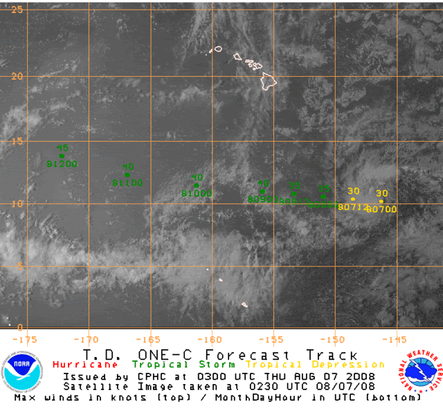
THE SMALL LOW PRESSURE SYSTEM TRACKED AS INVEST 92C FAR SOUTHEAST OF
HAWAII HAS BECOME MORE ORGANIZED OVER THE PAST SIX HOURS...AND
THOUGH STILL SMALL CAN NOW BE CALLED TD ONE-C. SATELLITE IMAGERY
HAS SHOWN THAT A WELL-DEFINED SURFACE CENTER HAS FORMED DURING THE
COURSE OF THE DAY...WITH PERSISTENT DEEP CONVECTION NEAR THE LOW
LEVEL CIRCULATION CENTER. DVORAK CLASSIFICATION FROM PHFO AND JTWC
WERE 2.0 WITH SAB COMING IN AT 2.5. HAVE GONE WITH THE FIRST TWO...
PLACING MAXIMUM WINDS AT 30 KT.
...
Interesting that they mentioned the invest number. I've never seen that done before.
Didn't see that. That's quite remarkable, first time I see that. They usually never mention that it was "invest x" before becoming a cyclone