CPac: 93C.INVEST west of TS Kika
Moderator: S2k Moderators


CPac: 93C.INVEST west of TS Kika
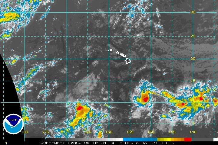
New INVEST 93C located at 9.0N 166.3W according to ATCF. West of Kika.
0 likes


Re: CPac: 93C.INVEST west of TS Kika
We rarely get 3 storms in a year here, let alone in one week. Kind of reminds me of 1994 when Hurricanes Emilia, Gilma and Li within a few weeks of each other. Plus that year Emilia, Gilma and John all reached Category 5 strength within the Central Pacific Basin
0 likes

Re: CPac: 93C.INVEST west of TS Kika
CPHC TWO wrote:400 PM HST THU AUG 7 2008
FOR THE CENTRAL NORTH PACIFIC...BETWEEN 140W AND 180
1. Tropical Storm Kika centered near 11N 151W, or about 650 miles south southeast of Hilo, continues to slowly develop and move west at 10 to 15 mph.
2. An area of disturbed weather associated with a surface trough is located about 1050 miles southwest of Honolulu. Development of this system, if any, is expected to be slow to occur as it moves westward at about 15 mph.
3. Another area of disturbed weather has formed about 1400 miles east southeast of Hilo. Slow development of this system is possible during the next couple of days as it moves west northwestward at 10 to 15 mph.
Otherwise, no tropical cyclones are expected through Saturday afternoon.
Public advisories on Tropical Storm Kika are issued under WMO header WTPA31 and under AWIPS header HFOTCPCP1. Forecast/advisories on Tropical Storm Kika are issued under WMO header WTPA21 and under AWIPS header HFOTCMCP1.
This is the busiest Tropical Weather Outlook I have ever seen from the CPHC. This is incredible for a Neutral year.
I had a feeling this could also be watched when I was looking at the large image of the Pacific. I didn't know if I should have circled this area as well or not. Maybe I should update the image...
If the Cpac does get 3 storms in one week, my jaw will fall with enough velocity to break through the floor beneath me. I don't even know if an El Nino has ever featured that. This would definitely count as an explosion in activity for the Pacific.
0 likes

-
Typhoon Hunter
- WesternPacificWeather.com

- Posts: 1215
- Age: 40
- Joined: Wed Oct 11, 2006 11:37 am
- Location: Hong Kong
- Contact:
Re: CPac: 93C.INVEST west of TS Kika
What a wonderful image Cyclenall, especially since non of them are really threatening land (except a few rocky outcrops home to some seagulls!)
0 likes
ACPN50 PHFO 080800
TWOCP
TROPICAL WEATHER OUTLOOK
NWS CENTRAL PACIFIC HURRICANE CENTER HONOLULU HI
1000 PM HST THU AUG 7 2008
FOR THE CENTRAL NORTH PACIFIC...BETWEEN 140W AND 180
1. THE CENTRAL PACIFIC HURRICANE CENTER IS ISSUING ADVISORIES ON
TROPICAL STORM KIKA....LOCATED ABOUT 610 MILES SOUTH SOUTHEAST OF
HILO.
2. AN AREA OF DISTURBED WEATHER ASSOCIATED WITH A SURFACE TROUGH IS
LOCATED ABOUT 1100 MILES SOUTHWEST OF HONOLULU. DEVELOPMENT OF THIS
SYSTEM...IF ANY...IS EXPECTED TO BE SLOW TO OCCUR AS IT MOVES
WESTWARD AT ABOUT 20 MPH.
3. ANOTHER AREA OF DISTURBED WEATHER CENTERED ABOUT 1300 MILES
EAST-SOUTHEAST OF THE HAWAIIAN ISLANDS IS POORLY ORGANIZED. SLOW
DEVELOPMENT OF THIS SYSTEM IS POSSIBLE DURING THE NEXT COUPLE OF
DAYS AS IT MOVED WEST-NORTHWESTWARD AT 10 TO 15 MPH.
OTHERWISE...NO TROPICAL CYCLONES ARE EXPECTED THROUGH SATURDAY
AFTERNOON.
PUBLIC ADVISORIES ON TROPICAL STORM KIKA ARE ISSUED UNDER WMO HEADER
WTPA31 PHFO AND UNDER AWIPS HEADER HFOTCPCP1. FORECAST/ADVISORIES ON
TROPICAL STORM KIKA ARE ISSUED UNDER WMO HEADER WTPA21 PHFO AND
UNDER AWIPS HEADER HFOTCMCP1.
$$
MORRISON
0 likes
-
Ad Novoxium
- Category 1

- Posts: 348
- Age: 33
- Joined: Sat May 03, 2008 2:12 am
Re: CPac: 93C.INVEST west of TS Kika
Just to keep as a reminder, the current record for most tropical storm formations in the CPac in one year is four (1982, the first year of Hawaiian naming, saw the formations of Akoni, Ema, Hana, and the devastating Iwa).
0 likes


Who is online
Users browsing this forum: No registered users and 73 guests