Ex Invest 93L in Central Atlantic

Moderator: S2k Moderators

Message
Author
User avatar
cycloneye
Admin
Admin
Posts: 139086
Age: 67
Joined: Thu Oct 10, 2002 10:54 am
Location: San Juan, Puerto Rico

Re:

#181 Postby cycloneye » Fri Aug 15, 2008 8:10 am

HURAKAN wrote:Today we may see some mention of possible RECON for tomorrow or the next day. The system is already very close to 50W and still a bit south of 15N. Lesser Antilles need to keep an eye on it.


Agree about that.After 92L passed the Eastern Caribbean islands without big fanfare,all eyes have to turn east and watch this.
0 likes   

User avatar
canegrl04
Category 5
Category 5
Posts: 2486
Joined: Thu Aug 26, 2004 5:37 pm
Location: Texas

Re: ATL: Invest 93L in Central Atlantic

#182 Postby canegrl04 » Fri Aug 15, 2008 8:23 am

I'm beginning to think 93L has better potential than good looking wave 92L.Besides,92L will probably get chewed up and spit out over DR
0 likes   

User avatar
HURAKAN
Professional-Met
Professional-Met
Posts: 46086
Age: 37
Joined: Thu May 20, 2004 4:34 pm
Location: Key West, FL
Contact:

#183 Postby HURAKAN » Fri Aug 15, 2008 8:41 am

Elsewhere in the tropics
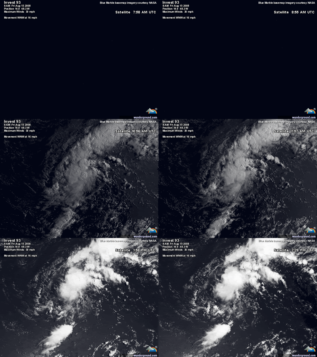
A tropical wave (93L), near 14N 49W, about 700 miles east of the Lesser Antilles Islands, has gotten better organized this morning. Wind shear has fallen to 10 knots, and is expected to remain below 10 knots the next two days. The system does have a closed circulation at the surface, as seen on last night's QuikSCAT pass. The surface circulation is also apparent on visible satellite loops, as well as a slow increase in heavy thunderstorm activity. NHC has given the reasonable forecast that there is a medium (20-50%) chance that this system will be a tropical depression by Sunday morning. Most of the computer models track this storm well north of the Lesser Antilles Islands, recurving out to sea.

Link: http://www.wunderground.com/blog/JeffMa ... amp=200808
0 likes   

User avatar
KWT
Category 5
Category 5
Posts: 31390
Joined: Tue Aug 17, 2004 11:02 am
Location: UK!!!

#184 Postby KWT » Fri Aug 15, 2008 9:11 am

It probably will be the case that this gets more impressive then 92L does, its typical on this board that there are some that everyone watches whilst the actual one that goes onto do something major sneaks on by and only when it blows people suddenly notice it.

Interesting right now its right on the same path as 92L as well, maybe a touch north of it, will be interesting to see if it takes a similar path as 92L as well despite what some of the models suggest.
0 likes   

User avatar
HURAKAN
Professional-Met
Professional-Met
Posts: 46086
Age: 37
Joined: Thu May 20, 2004 4:34 pm
Location: Key West, FL
Contact:

#185 Postby HURAKAN » Fri Aug 15, 2008 9:14 am

Image

A question to AccuWeather, if 92L has a tropical low and 93L has a low, is the low of 93L not tropical or are them both tropical???

:eek: :lol: WE MAY NEVER KNOW THE ANSWER :eek: :lol:
0 likes   

User avatar
gatorcane
S2K Supporter
S2K Supporter
Posts: 23499
Age: 46
Joined: Sun Mar 13, 2005 3:54 pm
Location: Boca Raton, FL

#186 Postby gatorcane » Fri Aug 15, 2008 9:48 am

so is 93L the real one to be concerned about? Seems to be tracking right behind 92L and may have a ridge over the Western Atlantic to work with in the 5-7 day timeframe?
0 likes   

User avatar
HURAKAN
Professional-Met
Professional-Met
Posts: 46086
Age: 37
Joined: Thu May 20, 2004 4:34 pm
Location: Key West, FL
Contact:

#187 Postby HURAKAN » Fri Aug 15, 2008 9:49 am

Image

Convection may be weakening but banding is developing to the north and south and it was a really good spin.
0 likes   

User avatar
gatorcane
S2K Supporter
S2K Supporter
Posts: 23499
Age: 46
Joined: Sun Mar 13, 2005 3:54 pm
Location: Boca Raton, FL

#188 Postby gatorcane » Fri Aug 15, 2008 10:03 am

could 93L become Fay before 92L? Looking at 93L I think the chances have increased :uarrow:
0 likes   

OuterBanker
S2K Supporter
S2K Supporter
Posts: 1704
Joined: Wed Feb 26, 2003 10:53 am
Location: Nags Head, NC
Contact:

#189 Postby OuterBanker » Fri Aug 15, 2008 11:11 am

180 pages vs 10, poor 93L. No attention paid. Just being ignored poor thing. BTW, any models run on this?
0 likes   

User avatar
HURAKAN
Professional-Met
Professional-Met
Posts: 46086
Age: 37
Joined: Thu May 20, 2004 4:34 pm
Location: Key West, FL
Contact:

Re:

#190 Postby HURAKAN » Fri Aug 15, 2008 11:13 am

OuterBanker wrote:180 pages vs 10, poor 93L. No attention paid. Just being ignored poor thing. BTW, any models run on this?


Go to the models thread!

viewtopic.php?f=59&t=102447&p=1769931#p1769931
0 likes   

User avatar
Hyperstorm
Category 5
Category 5
Posts: 1500
Joined: Sun Sep 07, 2003 3:48 am
Location: Ocala, FL

Re: ATL: Invest 93L in Central Atlantic

#191 Postby Hyperstorm » Fri Aug 15, 2008 11:31 am

Against what the NHC has stated, I don't think this system has any chance of doing anything anytime soon. See that upper level low NE of the 92L? That system will be a big inhibitor during the next few days.
0 likes   

User avatar
cycloneye
Admin
Admin
Posts: 139086
Age: 67
Joined: Thu Oct 10, 2002 10:54 am
Location: San Juan, Puerto Rico

Re: ATL: Invest 93L in Central Atlantic

#192 Postby cycloneye » Fri Aug 15, 2008 1:23 pm

SSD dvorak:

15/1745 UTC 15.1N 49.5W T1.0/1.0 93L -- Atlantic Ocean
0 likes   

Praxus
Category 1
Category 1
Posts: 473
Joined: Tue Aug 31, 2004 3:19 pm

Re: ATL: Invest 93L in Central Atlantic

#193 Postby Praxus » Fri Aug 15, 2008 5:22 pm

Humming along

Image
0 likes   

User avatar
HURAKAN
Professional-Met
Professional-Met
Posts: 46086
Age: 37
Joined: Thu May 20, 2004 4:34 pm
Location: Key West, FL
Contact:

#194 Postby HURAKAN » Fri Aug 15, 2008 7:58 pm

15/2345 UTC 15.1N 50.7W TOO WEAK 93L

A lot of wind shear affecting this system.
0 likes   

User avatar
deltadog03
Professional-Met
Professional-Met
Posts: 3580
Joined: Tue Jul 05, 2005 6:16 pm
Location: Macon, GA

#195 Postby deltadog03 » Fri Aug 15, 2008 8:50 pm

The new tutt/ULL is kicking 93L's butt.
0 likes   

User avatar
HURAKAN
Professional-Met
Professional-Met
Posts: 46086
Age: 37
Joined: Thu May 20, 2004 4:34 pm
Location: Key West, FL
Contact:

#196 Postby HURAKAN » Sat Aug 16, 2008 7:18 am

Image

Image

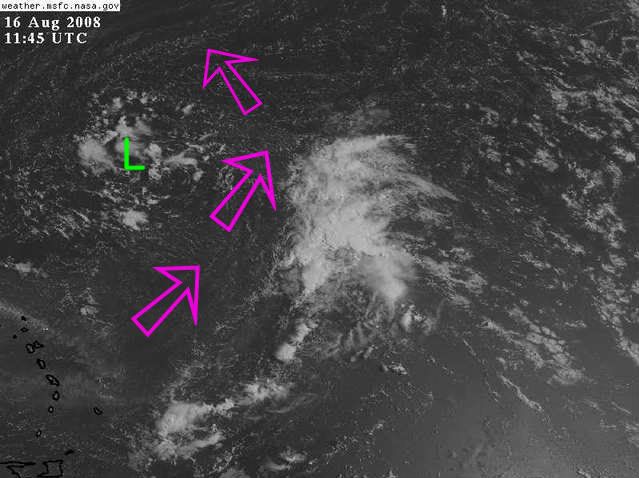
Shear forecast to be mostly favorable for development by 48 hrs.
0 likes   

fasterdisaster
Category 5
Category 5
Posts: 1868
Joined: Mon Sep 19, 2005 4:41 pm
Location: Miami, Florida

#197 Postby fasterdisaster » Sat Aug 16, 2008 8:56 pm

Does this look to be a fish?
0 likes   

Ed Mahmoud

Re:

#198 Postby Ed Mahmoud » Sat Aug 16, 2008 10:18 pm

fasterdisaster wrote:Does this look to be a fish?


Models seem to suggest 93L, if it even develops, sleeps with Lucca Brazzi.
0 likes   

User avatar
cycloneye
Admin
Admin
Posts: 139086
Age: 67
Joined: Thu Oct 10, 2002 10:54 am
Location: San Juan, Puerto Rico

Re: Ex Invest 93L in Central Atlantic

#199 Postby cycloneye » Sun Aug 17, 2008 6:00 am

Once again 93L is deactivated:

BEGIN
NHC
invest_DEACTIVATE_al932008.ren
FSTDA
R
U
040
010
0000
200808170951
NONE
NOTIFY=ATRP
END
0 likes   

User avatar
HURAKAN
Professional-Met
Professional-Met
Posts: 46086
Age: 37
Joined: Thu May 20, 2004 4:34 pm
Location: Key West, FL
Contact:

#200 Postby HURAKAN » Sun Aug 17, 2008 10:19 am

Image

Image

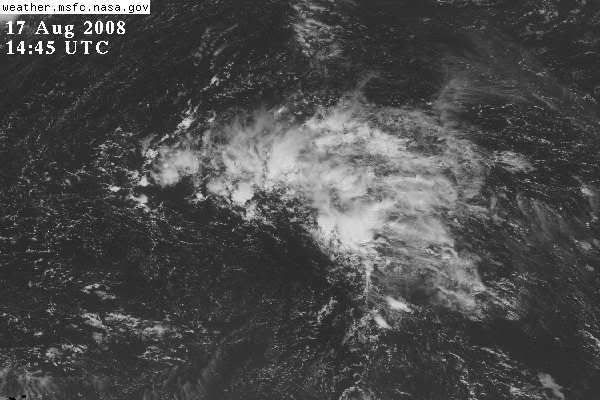
Convection appears to be shear induced.
0 likes   


Return to “2008”

Who is online

Users browsing this forum: No registered users and 108 guests