BEGIN
NHC
invest_al942008.invest
FSTDA
R
U
040
010
0000
200808181207
NONE
NOTIFY=ATRP
END
INVEST, AL, L, , , , , 94, 2008, DB, O, 2008081812, 9999999999, , , , , , METWATCH, , AL942008
AL, 94, 2008081812, , BEST, 0, 127N, 344W, 25, 0, DB, 0, , 0, 0, 0, 0,
ftp://ftp.tpc.ncep.noaa.gov/atcf/tcweb/
Thread at Talking Tropics:
viewtopic.php?f=31&t=102579&p=1777150#p1777150
ATL GUSTAV: Tropical Depression - Discussion
Moderator: S2k Moderators
-
Canelaw99

- S2K Supporter

- Posts: 2112
- Age: 47
- Joined: Tue Aug 31, 2004 8:27 am
- Location: Homestead, FL
Re: ATL: Invest 94L WSW of Cape Verde Islands

At least it'll be a while before it gets over this way, if at all....
0 likes
-
Matt-hurricanewatcher

- Category 5

- Posts: 11649
- Age: 38
- Joined: Fri Nov 26, 2004 11:09 pm
- Location: Portland,OR
- Contact:
Re: ATL: Invest 94L WSW of Cape Verde Islands
Only 7 post for this in the other forum before it was upgraded to a invest. WOW.
This thing looks pretty good overall. In has model support, at least from the Gfs. We will see.
This thing looks pretty good overall. In has model support, at least from the Gfs. We will see.
0 likes

-
DESTRUCTION5

- Category 5
- Posts: 4391
- Age: 42
- Joined: Wed Sep 03, 2003 11:25 am
- Location: Stuart, FL
-
DESTRUCTION5
- Category 5
- Posts: 4391
- Age: 42
- Joined: Wed Sep 03, 2003 11:25 am
- Location: Stuart, FL
-
cycloneye

- Admin

- Posts: 139052
- Age: 67
- Joined: Thu Oct 10, 2002 10:54 am
- Location: San Juan, Puerto Rico
Re: ATL: Invest 94L WSW of Cape Verde Islands
In case members didnt see the 8 AM Tropical Weather Outlook making reference to this new system,here it is:
927
ABNT20 KNHC 181154
TWOAT
TROPICAL WEATHER OUTLOOK
NWS TPC/NATIONAL HURRICANE CENTER MIAMI FL
800 AM EDT MON AUG 18 2008
FOR THE NORTH ATLANTIC...CARIBBEAN SEA AND THE GULF OF MEXICO...
THE NATIONAL HURRICANE CENTER IS ISSUING ADVISORIES ON TROPICAL
STORM FAY...CENTERED ABOUT 80 MILES EAST-NORTHEAST OF HAVANA CUBA.
 AN AREA OF DISTURBED WEATHER HAS FORMED ABOUT 600 MILES
WEST-SOUTHWEST OF THE CAPE VERDE ISLANDS. SLOW DEVELOPMENT OF THIS
SYSTEM IS POSSIBLE OVER THE NEXT COUPLE OF DAYS AS IT MOVES
WESTWARD ABOUT 15 MPH.
ELSEWHERE...TROPICAL CYCLONE FORMATION IS NOT EXPECTED DURING THE
NEXT 48 HOURS.
$$
FORECASTER BEVEN
927
ABNT20 KNHC 181154
TWOAT
TROPICAL WEATHER OUTLOOK
NWS TPC/NATIONAL HURRICANE CENTER MIAMI FL
800 AM EDT MON AUG 18 2008
FOR THE NORTH ATLANTIC...CARIBBEAN SEA AND THE GULF OF MEXICO...
THE NATIONAL HURRICANE CENTER IS ISSUING ADVISORIES ON TROPICAL
STORM FAY...CENTERED ABOUT 80 MILES EAST-NORTHEAST OF HAVANA CUBA.
WEST-SOUTHWEST OF THE CAPE VERDE ISLANDS. SLOW DEVELOPMENT OF THIS
SYSTEM IS POSSIBLE OVER THE NEXT COUPLE OF DAYS AS IT MOVES
WESTWARD ABOUT 15 MPH.
ELSEWHERE...TROPICAL CYCLONE FORMATION IS NOT EXPECTED DURING THE
NEXT 48 HOURS.
$$
FORECASTER BEVEN
0 likes
-
Matt-hurricanewatcher
- Category 5
- Posts: 11649
- Age: 38
- Joined: Fri Nov 26, 2004 11:09 pm
- Location: Portland,OR
- Contact:

-
Gustywind

- Category 5
- Posts: 12334
- Joined: Mon Sep 03, 2007 7:29 am
- Location: Baie-Mahault, GUADELOUPE
http://cimss.ssec.wisc.edu/tropic/real- ... g8sht.html
Low shear should provide surprises in store, very low givent its location and during its probable trip....
Low shear should provide surprises in store, very low givent its location and during its probable trip....
0 likes
-
Matt-hurricanewatcher
- Category 5
- Posts: 11649
- Age: 38
- Joined: Fri Nov 26, 2004 11:09 pm
- Location: Portland,OR
- Contact:
Re: ATL: Invest 94L WSW of Cape Verde Islands
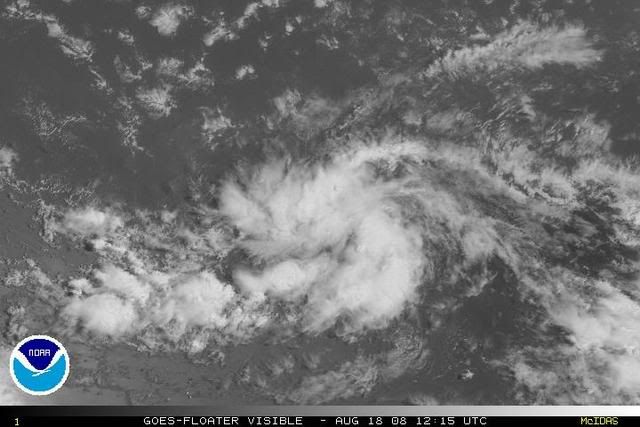
Looks like a depression. You have convection trying to also form over it with good banding trying to get going. It should not be long before t numbers come out.
Almost looks better then fay. Hell if you trended places with Fay. I bet there would be little difference still in what is what.
Almost looks better then fay. Hell if you trended places with Fay. I bet there would be little difference still in what is what.
Last edited by Matt-hurricanewatcher on Mon Aug 18, 2008 8:07 am, edited 1 time in total.
0 likes
-
HURAKAN

- Professional-Met

- Posts: 46086
- Age: 37
- Joined: Thu May 20, 2004 4:34 pm
- Location: Key West, FL
- Contact:
Code: Select all
 *   ATLANTIC SHIPS INTENSITY FORECAST       *
                    *        GOES/OHC INPUT INCLUDED            *
                    *      INVEST  AL942008  08/18/08  12 UTC   *

TIME (HR)          0     6    12    18    24    36    48    60
SHEAR (KTS)        9    10     9     3     3    14    17    15    16    13    15    11    12
SST (C)         28.2  28.1  28.0  27.9  27.8  27.3  26.8  26.9  27.2  27.3  27.9  28.4  28.5
0 likes
-
carolina_73

- Tropical Storm

- Posts: 148
- Joined: Wed Jul 23, 2008 1:30 am
Re: ATL: Invest 94L WSW of Cape Verde Islands
Looks VERY GOOD!!! This one is quite a low tracker. It is still a long ways out ...but the setup looks as if this could be a serious player down the road.
0 likes
-
Gustywind
- Category 5
- Posts: 12334
- Joined: Mon Sep 03, 2007 7:29 am
- Location: Baie-Mahault, GUADELOUPE
Latest from NRL site 12,7 N 34,4W 25 kts 1009 hpa
http://www.nrlmry.navy.mil/tc-bin/tc_ho ... &TYPE=ssmi
Healthy Invest 94L the next 12h should be pretty interressing given the current conditions ahead of this feature...
http://cimss.ssec.wisc.edu/tropic/real- ... 8split.jpg
Weak SAL is doting the area only small pockets can be seen....
http://www.nrlmry.navy.mil/tc-bin/tc_ho ... &TYPE=ssmi
Healthy Invest 94L the next 12h should be pretty interressing given the current conditions ahead of this feature...
http://cimss.ssec.wisc.edu/tropic/real- ... 8split.jpg
Weak SAL is doting the area only small pockets can be seen....
0 likes
Who is online
Users browsing this forum: No registered users and 45 guests